Saturday, December 14, 2013

Reading Between the Lines

From Stephen Smith:
The Guadalupe-Lamar corridor was, Project Connect conceded, by far the most popular option at the three public information sessions held throughout the city. Still, the team contended that based on the crowds’ preferences for priorities — congestion and development potential, for example — the Highland and East Riverside routes were actually better fits.
What does this quote mean? Well, the context is that we are discussing Austin's light rail proposal. Unfortunately, this quote cuts to the quick of everything that's wrong with our mass transit engineering process today:
The Guadalupe-Lamar corridor was, Project Connect conceded, by far the most popular option at the three public information sessions held throughout the city.
There's a reason for this: this is the highest-ridership route in Austin. In European mass transit planning, the rule is: reinvestments get priority. If you have sardine-can packed buses and empty light rail, you're doing something wrong. Light rail, as a mode, has higher capacity than buses and so is best used alleviating pressure on high-demand corridors. That is, a busy bus route is a demonstration of the need for light rail.

So what's going wrong? The statement
...the team contended that based on the crowds’ preferences for priorities — congestion and development potential...
suggests an intrinsic failure of the planning process. While I agree that we the professionals need to listen to members of the community, I fear this is the point when things start to go to far. If we tried to give the public their every demand, we'd wind up with a fat, blatantly self-contradictory, service-intensive set of asks and not a single new penny to pay for it (indeed, our coffers would likely be lighter). Part of the point of being a professional, of actually spending the time and energy learning the discipline, is to be able to winnow what the public actually needs out from what it thinks it needs. Of course, as Jane Jacobs helpfully pointed out in Death and Life, and Chuck Marohn points out on Strong Towns today, bad professional priorities cause their own problems, so this drives a professional ask: accountability that our priorities and standards are current and reflective of reality.

Seemingly in the (misguided) belief that the first half of the 20th century was a golden age in the development of architecture, urban planning, and transportation engineering, however, our professional priorities skew towards prescribing the ideals of Ebenezer Howard, Le Corbusier, etc., and proscribing the traditional development pattern that they rejected. These ideals have, over the past fifty years, proven to be remarkably far from reality.

But of course the final statement (there is some overlap)
...priorities — congestion and [economic] development potential, for example — the Highland and East Riverside routes were actually better fits
is where the hammer really hits. The Boomer buzzwords "congestion" and "economic development" were never the crowds' priorties--they're the engineers'. In fact, the crowd has made it clear what their priority is: better transit down the busiest route in the city. The problem is that this priority doesn't jive with the consultants' priorities--the Suburban Growth Experiment build-it-and-they-will-come idea instead of maintenance and intensification of a proven success; it doesn't jive with the City's priority, as they wish to service a new-build district; and it doesn't jive with U. of Texas' administration's priority, which for some asinine reason wants to keep the light rail away from the campus's west side--exactly where the greatest student concentration (and hence ridership) is. These all converge in the northeast corridor.

And the futon

So you're consultants with years of experience developing in suburbia caught in pitched battle. On one side you've got proven ridership and public desire for light rail in Corridor A; on the other administrators galore breathing down your necks for Corridor B. So what do you do? Why, you split the difference, of course, and roll out a compromise Corridor C!

...Except that this corridor is like the stroad of transit investments. It's too far from the ridership core that gives Corridor A its strength; it's too far from the underutilized infrastructure that gives Corridor B its strength. What it is, instead, is a corridor that is of use to the people living along it, but fails to capitalize on either of the (opposing) corridors being advanced. It is, in every objective sense, a failure, a futon.

Austin already has one mass-transit futon. Does it need another one?

Tuesday, December 10, 2013

Land use is the derivative of the transportation system

Something I've been mulling over:

Land use is the derivative of the transportation system. What I mean by this is that the nature of the land use system is wholly dependent on the local dominant transportation system. Hence a rail-oriented transportation system sees incredible centralization, pedestrian- and bike-oriented ones a dense spread, and automobile-oriented ones...sprawl.

Perhaps "derivative" isn't the right word in a technical sense, but it certainly sounds sexier than "dependent variable". And we want mantra here. We need mantra, because we need to focus on the problem at its core, because the reality is--there's a reason why planners are so often hamstrung, and it's because they're fighting a system dictated by the engineers. So while Euclidean planning standards don't help--parking requirements especially--the place to focus action would be with the engineers, to make it possible to engineer real streets, real platforms for value creation, again.

Repeat after me: Land use is the derivative of the transportation system. Land use is the derivative of the transportation system. Land use is the derivative of the transportation system.

Sunday, November 24, 2013

Energy Thoughts

Two thoughts:

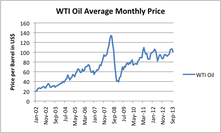
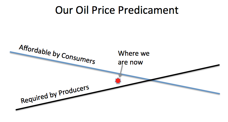
1. I would like to call attention to two images in this post.
While the author does not flat-out say it, if you take a look at the oil price trajectory since roughly the beginning of 2011, you will notice that it is periodic, and that it appears to be defined by upper and lower bounds. In mathematics, these would be called the superior and inferior limits (limsup and liminf, respectively). These limits are converging, and models defined by these qualities yield functions such as

y(t)=[Ae^(bt/2m)^2][cos(ωt+φ)].

(This model is based on the damped periodic motion model, but with the hyperbolic limit converted to a parabolic one. A result of this is that the limsup and liminf are not linear the way they are in Gale the Actuary's visual model, but rather quadratic, with shared minima at the origins. Such a model is not as exact as I would like, but I have not yet been successful at specifying a periodic function with linear limits whose slope is nonzero. Of course, other possible permutations exist; for example, what we are treating as the origin may be more like a wave node.)*

In the math, there is a symmetry about the origin. But in reality, the problem is that the secondary feedbacks break this symmetry; the model after the origin would be dramatically different than prior to it. It does not matter what the space between the "Affordable by Consumers" function and "Required by Producers" one is, as long as what is "Required By Producers" is in overshoot of what's "Affordable by Consumers". In reality--and this is likely what Gail the Actuary's article is getting at--once the crossover is passed, producers will be forced to sell product at a price in line with the liminf; the instability of this model would, at first, be hidden via leveraging, consolidation, and conglomeration, but would ultimately exert itself through a breaking point--most likely systemic insolvency.

2. One of the commentators on the late site The Oil Drum held a certain optimist viewpoint. Energy was more expensive in the past, during the coal era, while society and the economy were vibrant; why, then, he argued, should more expensive energy cause economic contraction?

The problem is that he was right and wrong at the same time. I would like to propose a hypothesis: that the story of the Industrial Revolution was a reduction in the overall net cost of energy. However, this cost bottomed out in the era 1945-1970, the era of cheap American oil; the oil embargo and its aftereffects allowed us to leverage this cost into the future, but what I propose is that a model of the real cost of energy would show that that it has behaved like a Gaussian function--an inverted bell curve, in fact--and that we are now far enough beyond the point of local minimum to see this and not mistake it for a logistic curve or decaying exponential function. Something like

y(x)=-ae^(((x-b)/2c)^2)+d,

where d is the "normal" cost of energy the curve is asymptotic to, e is the transcendental number, and a, b, and c are other parameters.

For the argument I wish to make, however, we can approximate the curved element of the function as a simple quadratic, say

y(x)=x^2/4-x+3

The reason we'll do this is because the problem with this commentator's argument is that it ignores the change in the cost of energy over time: that is, it treats this cost as a static element. If one derives this function, dy/dx=x/2-1 via the power rule, to obtain the slope of the tangent line, and utilize this to find its behavior at, say, y(0), one will quickly see that such a line is negative. That is, prior to the minimum, the net cost of energy is decreasing. And of course, after it, it is increasing.

As much of the current economic system is predicated on the assumption that said cost is always decreasing (assuming it can be modeled by y=-x^3, whose derivative, -3x^2, always yields a negative tangent line, maybe?), creation of, and access to, flows of capital would have been significantly easier even when the net cost of energy was higher if its change over time was a decrease. In a post-Peak Oil era, that net cost is always increasing--if we are lucky, we might be able to apply enough renewables to the overall mix for it to balance at a level lower than its c. 1600 cost--but, because of this fact of elementary calculus, dependent secondary systems with flawed assumptions about the nature of the primary system will be unable to adapt to the new status quo.

This does not, of course, translate into a "doomer" argument, such as the ones Mr. Kunstler is fond of. Instead, it merely states that dependent secondary systems on the cost of fuel must adapt to changes in the trajectory of the primary system, or fail. The issue at hand is, what are the necessary adaptations? Doomers are fond of pointing out the structural weaknesses that they believe end in failure; they are much less fond of considering the consequences of this change in trajectory, and the adaptations needed for the dependent systems to continue working. It's this latter line of inquiry I find much more interesting.

*NOTE: One of the effects, the asymmetry about the origin, becomes clearer if one cubes the squared exponential parameter of e, i.e. y(t)=[Ae^(-(bt/2m)^3][cos(ωt+φ)], with the core remaining the damped periodic motion model. Cubed limsup and liminf also do cross over, an issue inherent in the squared ones. This model, however, flatlines after the origin, such that it becomes effectively impossible to use it to tell anything about what happens after the crossing point.

Tuesday, September 3, 2013

Width, and the Perception of Width

This has also run on Strong Towns and This Old City; these are the permalinks for both.

Looking at these two links--Hector Street, Conshohocken, and 6th St., Bella Vista--which is wider?
Looking at these two links--Broad Street, Philadelphia, and Avenue Kléber, Paris--which is wider?
Looking at these two pictures--
--which is wider?

The answer is neither. In each example, both streets are the same width, but the way the width is expressed is different. The middle example is, of course, familiar to Stroad to Boulevard readers; let us concentrate on the bottom example.

The top photo is of a complete street in the Netherlands. It has two travel lanes of 10 feet, a parking lane with tree bumpouts of eight feet, and ample bike and sidewalk facilities. Its Streetmix profile is thus
where the planter+tree on one side represents the bumpout, and the parked car on the other the parking lane. Visualize the tree above the car, and the car below the tree, to get a better idea of how it looks in reality.

By contrast, the US complete street's Streetmix profile is
Notice how scrunched up the sidewalk is, and how vulnerable the cyclists.

Both examples have nine-foot sidewalks and eight-foot parking lanes. In the Netherlands, the travel lanes are only ten feet wide, and the cycle path looks to be eight feet; in the US, the travel lanes are 12 ft. each, and the cycle path is six feet. Both add up to 70.

But also notice how the placement of each use in the street communicates information about it. In the US example, cars are clearly given priority, not just by being given wider travel lanes, but also because the bike lanes are placed in such a manner as to expand the travel lanes' clear zone. There are no bumpouts, and so the trees are scrunched along the curb, and pedestrians forced onto the sidewalk. Of the seventy feet, a whopping 52 is part of the car realm, just shy of 75%. This means that for every unit of pedestrian space, there are four of auto space, a ratio of 1:4.

By contrast, in the Dutch example, cars are clearly subsumed. The travel lanes are narrowed, and the parking lane is interspersed with bumpouts; the parking lanes now become the edge space. The bike lanes have been pulled away from potential conflicts, and widened slightly. The sidewalks remain the same width, but there are no trees to present barriers. In this example, a mere 36 feet of seventy is part of the auto realm, if you count the bumpouts as also part of it, giving a ratio very nearly 1:1.

Just as the optimal building height/street width ratio is 1:1, so too is the pedestrian realm/auto realm on a street. This ratio seems to be paramount in the psychological assessment of street width. Hence we can do the analysis we just did for a typical Dutch arterial vs. a typical US Main Street, and still get questions like

Why streets in the US are so wide?

There is space for two row of parked car on both sides and about three times the width of a vehicle in the middle. But technicaly there is no need to park on the road because most house have one or two garages and a lot of space in front of them. I think that`s a waste of space and structure.
and answers like
Because until a few years ago, people looked at safety data from rural roads, and found that roads with 12 ft lanes and wide shoulders had fewer crashes. So, they applied this to residential streets, and guess what? It hasn't worked. Instead of being safer, people drive down these streets as if they were on rural highways, at speed much too fast for neighborhoods.

In the future, you'll see roadways designed more closely for the functions they play in the overall road network, with narrower city and neighborhood streets.
The psychological assessment of width the commentator exhibited is what I am calling perceived width, or alternately the perception of width. Unlike absolute width, which is determined by the lot lines, perceived width is determined by the modulation of the street--how much is given over to cars and pedestrians (and whether bikes are treated as cars or pedestrians)--as well as setback depth (if any). Optimal modulation has the two major users evenly split the street, and setbacks, if they exist at all, be purely ceremonial (no more than 15 ft. or so), or be shielded by an edge along the lot line, created by trees or bushes. We'll assume no setback, since that kind of space is usually (a) green and (b) in the public way of neither. That is, it is neither of the auto realm nor of the pedestrian realm.

Cars need a spatial minimum. The absolute minimum is often thought of as ten feet a travel lane, and eight feet a parking lane; parking lane accesses can, however, be nine feet. Give-way streets need slightly wider travel lanes, so that the car giving way can pull into a space without having to go through a full parallel-parking maneuver. Let's say 14-18 feet for them.

Let us now turn to our first example. Both streets are fifty feet, with ten-foot sidewalks. This implies that both can support give-way traffic; neither does. The Conshy example, however, hosts a bus and thus cannot be pedestrian-prioritized space--that is, a home zone. The design given to it is therefore nearly optimal. This is what it looks like on Streetmix:
The bumpout is irregular, with four parking spaces between each one (on each side of the street). In this, it's like a slightly less verdant example of the Dutch complete street. This design offers a wider walking area than the Philadelphia example:
Both designs, while good, are, however, inferior to
which uses the bumpout/parking strategy to increase available space without losing trees, but in addition narrows the travel lane and adds a cycle path. In this design, 26 feet are part of the auto realm, and 24 the pedestrian--as close to a 1:1 ratio as a 50' street is likely to get.

The second example contrasts Philadelphia's Broad Street--a classic example of a grand avenue converted into a traffic sewer arterial, with Paris' Av. Kléber. The former looks like
this on Streetmix
and the latter, this.

I find myself going into Stroad to Boulevard territory here: notice that there is 30' of pedestrian realm on either side of the street, versus 16' on Broad Street. The bike and parking functions are both elements of a single shared service street, which the sidewalk spills onto; transit islands can also be installed on the green medians separating the two realms from one another. The bottom line isn't just that there is more people space--and less car space--on the Av. Kléber; it's also that one perceives of the Av. Kléber as being more humanized, and narrow, than one does of Broad, which feels more autocentric, and wide.

The perception of width is the psychological element of street design. Psychologically more humane streets tend to attract more pedestrian activity, and more small-scale, innovative, and experimental economic uses catering to pedestrians. It is, at engineering scale, the same thing a parklet signals: the idea that people care about the street as a street, and not just a place for automobile movement and storage.

Saturday, July 6, 2013

More Cogent than I

While still an undercurrent in urbanist media, people are starting to take note of our fundamentally broken approach to passenger rail safety. This item from the usually-libertarian Competitive Enterprise Institute, for example, hits the nail on the head. It's extremely short, only seven pages, and describes more cogently and Steve Smith, or Alon Levy, or I, the challenges facing American rail transportation professionals.

The problem remains that this remains an issue that is unknown, and hence unremarked-on, by most people outside the profession and geeks whose interests tend that way. It also doesn't help that, as Business Insider points out, politics get in the way. This is an ongoing problem with land-use issues: it is very difficult for technocrats to reevaluate and rebuild fundamentally broken regulations when they are opposed by people who know those regulations are broken, and fundamentally just don't care, who would rather leave them in place to laugh at them and say they should be repealed outright* and say "this is why government is broken" rather than pitching in, lending a hand, and fixing them.

All that said, I find myself nodding in agreement with Edmonson and Scribner in their recommendation that
[i]f the FRA insists that the operational environment of the Untied States is uniquely dangerous, it should overhaul its regulatory mandates and take a step back from the prescriptive rules currently in place. Instead, it should create a series of performance metrics that would allow train designers to innovate. It now asks, “Does this train fit our rules?” It should ask, “Is this train survivable in a crash?”
 
This would allow U.S. transit authorities to purchase not only European trains, but also Japanese trains, which are designed to different effective standards. The United States could be a melting pot of train designs from around the world.
It can be done. But do we have the political will to do it?
______________
* Although, with the current FRA regulations, and the (nonexistent) state of our domestic passenger railcar industry, one can actually argue for its dissolution (as Alon Levy has in the past); European and Japanese products, the bulk of the market, have proven safety records our lemons don't.

Wednesday, April 10, 2013

NPT Card Accessibility

Short and sweet.

Make sure there are facilities to dispense and charge NPT cards at every single subway, El, Regional Rail, NHSL, and 101/102 stop.

Make sure there are facilities to dispense and charge NPT cards at every single Subway-Surface stop in the tunnel.

Make sure there are facilities to dispense and charge NPT cards at every single Subway-Surface loop.

Make sure there are facilities to dispense and charge NPT cards at principal bus nodes--anywhere, except for Center City or on the Frankford Terminal approaches, where three or more bus routes come together. This includes Wissahickon Transfer, the Ogontz Loop, Franklin Mills, King of Prussia, Penn's Landing, Front & Market, Whitman Plaza, Andorra, Plymouth Meeting, Willow Grove, and so forth. Additionally, ensure that NPT dispensaries are available at principal jobs hubs, such as HUP.

The goal is to maximize user accessibility, maximize ease of use, maximize user confidence.

Tuesday, April 9, 2013

What Oyster Teaches Us About Fare Collection

How it's done:
SEPTA's NPT wants to act like London's Oyster Card, but with an open platform. Many Oyster best practices are thus best practices SEPTA needs to implement.

1. Tap in, tap out. SEPTA's current NPT Regional Rail policy is extremely convoluted and commuter-optimized, essentially giving free fare one way in exchange for double fare the other. Anywhere where there's a viable workaround, this will ensure overloaded trains on the free side and empty trains on the double-fare side.

Instead, Oyster uses a validator system, which is just an electronic update of a proof-of-payment system. Proof-of-payment systems are tried and tested, and are in use on the River Line and throughout the MBTA and most newer commuter-rail and light-rail networks. And best of all, they can be policed in the same manner as other proof-of-payment systems--just check and see if the card is indeed showing an active trip  being taken, and fine the holder if not--like a transit traffic ticket.

2. Guide to workarounds. Another issue NPT has is zone implementation. Annoying, but the only alternative is a per-mile fee. Instead, use an Oyster-style intrazone transfer system. On the Oyster, where route transfers can avoid zone surcharges, pink transfer gates are installed, allowing for free transfers and cheaper routes. Think like at 69th St. or Fern Rock, here.
3. Fare cap. Right now, SEPTA wants NPT to have a trip cap--200 a month. Asides from "unlimited" cards getting in trouble with laws and stuff about false advertising, this is rather the wrong way to go about capping. Instead, cap fares. Oyster caps fares at a peak (or off-peak) (round-trip?) ticket of the highest fare used during that day. Since most London transfers are free, this (incidentally) caps Michael Noda's Upper Darby trip at $5.00 (assuming NHSL round trip, $0.50 "premium", and round trip fare capping) or $7.00 (assuming 123 round trip, $1.50 "premium", and round trip fare capping). His hypothetical fare peak at $11.50 would cease to exist.

Keep in mind the fare capping system I am proposing caps fares at the most expensive single round trip fare used. So if Mr. Noda went to Upper Darby but caught the 104, the fare cap would remain at $4.00 (since both the El and 104 within Upper Darby Township charge a $2.00 cash fare).

Of course, the problem of excessive "premium service" cost for the 123 remains, but a fare capping system makes it more bearable.

4. Make it easy, make it easy, make it easy. This needs to become a mantra. Make it easier on the user, make the system more transparent, and don't unfairly penalize folks who don't have a card. On the other hand, make it easy and natural for everyone to have a card--much like the average New Yorker's wallet has an MTA card, and the average Londoner's an Oyster Card.

Monday, April 8, 2013

A Tempest in a Teapot

I must admit, I was wrong. Full of sound and fury, signifying nothing.

Some time ago I went on a rant about how SEPTA and PATCO need to coordinate fare media. They do; so do SEPTA and DART, SEPTA and NJT, and NJT and PATCO (I do not think any NJT route goes over the Delaware Memorial Bridge).

My mistake is that I had assumed--based on very old information--that the Freedom Card had been built on an open platform. It is not. It is built on the same closed-source platform e.g. London's Oyster Card is.

By contrast, SEPTA's NPT is to be built on an open platform--and this, incidentally, will make it first in the nation to be--and so requiring it to be compatible with a closed system is significantly more technically difficult than the examples I've given previously, both here and on Michael Noda's blog. This does not absolve SEPTA completely--you can totally run (closed source) Microsoft Office on (open source) Linux running Wine, for example--but there's a second development that makes me wonder.

PATCO is jonesing about replacing its existing Freedom Card architecture. That makes me wonder: 1. Freedom Card, as it is, is all of five years old, hardly enough time to become technically obsolete (unless, you know, you're Microsoft or Nintendo), and 2. a fairly straight port of Oyster Card technology--you know, the same Oyster Card that is the model of how to do (nearly) everything right. But the news that PATCO is jonesing to replace Freedom, coming out as it has in the thick of NPT, strongly suggests to me that that move isn't meant so much to replace Freedom per se as it is migrating the Freedom architecture onto something compatible with NPT's open-platform architecture.

I'll repeat: the mistake I made was assuming Freedom was open-platform. If it was, that would put compatibility onus on SEPTA. But it isn't, and since SEPTA's NPT is to be open, that puts compatibility onus on PATCO. And from what I've heard, PATCO is being proactive about it. Thankfully.

Monday, March 18, 2013

The Outsize Value of Fare Coordination

or, why NPT and the Freedom Card need to be compatible

a working paper à la Nate Hood

"Organization before electronics before concrete" is an important German concept that refers to both a means of subdividing solutions and a philosophy for applying those subdivisions. The best solutions have the most impact for the money, after all, and the ones that have the most impact are generally those that cost the least to implement properly. Note adverb: Cheapskate "solutions" generally tend to fail. Since we are looking at proper solutions, and it follows that those with the highest cost-benefit ratios tend to be optimal in any circumstance, this means that "organizational" solutions, with an extremely low capital cost* relative to benefits. Because of this, fare coordination is an essential organizational problem, and one which, when implemented properly, contributes massively to systemwide user-friendliness.

This can be directly applied to SEPTA's NPT travails. User desires for NPT are fairly simple--one card to get where you're going, no matter on what or when. One card for any train to Trenton, Wilmington, Downingtown. One card that connects to PATCO and the River Line. One card that does it all. London's Oyster system is a template.

Why is it so hard to just follow a goddamn template?

SEPTA's working protocol for NPT is generally commendable: contactless, open-loop, easily integrated with next-gen credit and debit cards^ like Tokyo's Suica as well as other next-gen fare systems. But that's where its technical edge comes to an end: NPT is attempting an (untested) rollout of Regional Rail fare payment that is not at all in accord with the best templates (e.g. Oyster, which uses a modified proof-of-payment system)--something which I'm sure Sic Transit Philadelphia will give more info on in the near future--and a total failure to integrate the Freedom Card. To hell with fare coordination! sayeth 1234 Market. We want to protect our agency turf at all costs!

Integrating the Freedom Card is basic fare coordination. While it may be more limited than what SEPTA has in mind with NPT, it is not so limited as needing to be back-compatible with tokens. Like what NPT will be, the Freedom Card is also contactless, chip card-based, credit- and debit-card-integrated. It already has features SEPTA has in mind, and was designed to be open-ended enough to be compatible with NPT, predictable since NPT itself is something that has been kicked around for the better part of a decade now. It is Universal Gravitation to NPT's General Relativity. Any implementation of NPT in a fixed-fare environment (buses, trolleys, the subway, el, and NHSL) is going to act, technically, in the same manner as the Freedom Card. So take it as the technical base, and build a variable-fare system on top that works like the Oyster Card! Or, at the very least, make sure it has basic back-compatibility--something that all software developers know full well. It is not hard.

And the users will thank SEPTA. Suddenly, instead of having several agencies at cross-purposes with one another, and discrete fare payment media to match, a single card becomes a gateway to the region. Want to visit the Mercer Museum? No problem! Want to visit a friend in Burlington? No problem! Want to check out that trendy place that just opened in Haddonfield? No problem! It is because, once implemented, fare coordination provides these real, tangible user benefits that even the handful of primitive fare coordination systems in use in the U.S. are expansionary--the Clipper Card, growing at a rate of two agencies a year, for example, or the SmarTrip/CharmCard nexus, which has effectively tied together a fare-coordination network spanning two major cities (Baltimore and D.C.) and the better part of two states. It is because of this that there is only one fare media--the OV-Chipkaart--in use anywhere in the Netherlands. Build a core and other agencies (especially smaller ones which see more significant boosts) will want to climb on.

The point is that while more advanced fare payment systems are more advantageous to the transit agency, fare coordination is more advantageous to the user. And user advantageousness is what, frankly, makes or breaks borderline users, what drives ridership up--or down. SEPTA is not so large as to serve the entire Philadelphia region the way the MBTA is to Boston. If SEPTA truly wishes to make getting around the region using its services advantageous, it must make sure its connections with the regions' other agencies are also advantageous to the user. It must invest in fare coordination.

Unfortunately, it says a great deal about American mass transit that agencies here are obsessed not with implementing proven, and working, templates, but rather with inventing new "standards" that are optimized for themselves and themselves alone (and thus not really standards). All SEPTA has to do with NPT is implement an Oyster Card clone**. Alas, if they keep on the course they're going, they're going to botch it.
____________
* Organizational solutions usually also have relatively high human cost, because the nature of such solutions is that they require agency cooperation and/or integration, a difficult proposition in the U.S. environment where agency turf issues rule the roost. Regulation--requiring all agencies serving a particular metropolitan area to be fare-coordinated--may be a useful workaround, but on the other hand the integration of fare payment media with credit cards (already happening in Europe and Japan^) may well render the whole fare-coordination issue obsolete.
^ For example, D.C., where the SmarTrip system (itself compatible with MTA's CharmCard) is about to be phased out for a credit card-based payment system.
** See e.g. the YouTube link above for why.

Thursday, March 14, 2013

Setting the Record Straight

Somehow it's unsurprising that, in our state's game of political brinkmanship between PennDOT and Amtrak, the right wing supports killing the daily Pennsylvanian. The right wing's op-eds are fact-free tiresome rehashes. So fact-free, in fact, that in an amusing inversion of the norm, the comments are more educated than the articles themselves.

It is interesting that both rags appear to hail from the Pittsburgh area, and of course one--the Tribune-Review--makes the leap that Pittsburgh's ridership situation was symptomatic of the line as a whole:
Total Pittsburgh station passenger counts are falling, and The Pennsylvanian — with just one morning departure and one evening arrival there daily — “almost certainly” is serving “fewer than 100,000 per year or 270 people per day” and losing riders, which means even higher future subsidies, he writes.
Nothing could be further from the truth. Only one Pennsylvanian station suffered from declining ridership last year; as I've already explained, Pittsburgh suffers from a scheduling quirk that necessarily undermines its boarding counts (that is, departures are either too early or too late).
And in direct contradiction to the article's claims,  the Pennsylvanian's total ridership rose last year, as it had the year before and the year before that. The most recent figure I know of is a ridership of 207,016, a 2.2% increase over the prior year. This is not the Fort Pitt, whose ridership was 30 a day when it was discontinued. Rising ridership means more demand for the train--implying the most harmful possible move is to cut it.

Third--again, as I've already explained--the Pennsylvanian is price-competitive to the Turnpike for cross-state trips. It's not I-80 it's competing against. At any given time the effective cost for traversing the state on the Turnpike is a $30 toll plus approximately $30 in gas--that is, $60 total. Yes, the Turnpike is faster to Harrisburg--but the Pennsylvanian clearly supports other niches.
Riding The Pennsylvanian to Harrisburg costs $40 and takes 51⁄2 hours with stops. Dr. Haulk notes that Megabus has three daily nonstop Pittsburgh-Harrisburg trips that cost $14 or $16 and take 31⁄2 to 4 hours.
Dr. Haulk misses the point. It's not Pittsburgh that is fueling the Pennsylvanian in its current iteration--it's Altoona, Lewistown, Huntingdon--places where Megabus doesn't stop. And guess what? Altoona, Tyrone, Lewistown, Huntingdon--all have mid-morning or midday departures! Again, Pittsburgh's ridership isn't suffering because the train is a bad train, per se--it is because the train's schedule is built around convenience for the other side of Horseshoe Curve. Or, to put it bluntly, Pittsburgh's Pennsylvanian ridership is so low because there's only one Pennsylvanian--and it's oriented to Philadelphia.

Don't agitate to cut a useful service for Altoonans, Tyronians, Lewistowners, and Huntingdonians, friend Pittsburghers. Agitate instead to add a train useful to you.

But it's the Sentinel that commits the most grievous sins. When it says
If the state’s going to spend money on rail transportation, it should do so where money would be better spent. Continuing to upgrade the Harrisburg-to-Philadelphia line, or investing with NJ Transit on plans to bring commuter rail to the Scranton area, seem more palpable than maintaining money-losing service to Pittsburgh,
it is comparing apples and oranges (at the very least). The Keystones are (supposed to be) hourly service; naturally, when the train comes once an hour instead of once a day, it is significantly easier to take it. Lancaster demonstrates this. The still-a-long-ways-away NJ Transit Scranton proposal would probably not even be hourly past East Stroudsburg. But these trains run as corridor commuter trains. The Pennsylvanian is, at its heart, an intercity train linking Pennsylvania's two great urban heartbeats.

The sad thing is that the Sentinel bulldozed through the truth on its way to its fatuous conclusion.
Rail experts say that the line could prove profitable and popular one day, but getting there would require tens or hundreds of millions of dollars — some subsidized at the federal level, to be sure, but some on the backs of Pennsylvania taxpayers — to realign and straighten the route to allow for high-speed access.
Probably Almost certainly not the best quote, given that running speed can be brought up quite a bit in the current infrastructural envelope--but this, at least, hints at where we can start. It is not eliminating what is very much a useful service; it is not by investing the many billions of capital needed to make it full-fat HSR into the line whole. It is by incremental additions, incremental improvements. You can't justify infrastructural investment by divesting the infrastructure you already have.

And the first of these improvements is a second daily train, oriented to Pittsburgh rather than Philadelphia. Do that, and be surprised by how suddenly useful the train becomes.

Monday, February 18, 2013

Putting Pieces Together

This emerged as a comment to this Old Urbanist post, but was rejected because of its length:
So the conventional theory is dead wrong; the data show the actual catalyst occurred during WWII. (Interestingly, there seems to be a strong correlation with home ownership and car ownership between the 1920s and 1950s; secondly, car ownership rises abruptly after WWII and surpasses the home-ownership rate.)

This, of course, begs the second question which the automotive theory "solved": the postwar collapse of the American city. My guess is that it was a combination of factors--some still at work--including a desire to emulate lifestyles portrayed in entertainment media, race, inefficient/incompetent/oversized city government, and even the ability to "cash out".

Think about it for a moment: the initial homeownership boom occurred BEFORE the Levitt brothers started their tract community, BEFORE detached housing became regulated as the dominant and standard housing type in zoning codes. If the initial catalyst for the homeownership surge was owners taking their properties off the rental market to avoid wartime rent controls, then it also stands to reason that the following sequence of events could have taken place:

1. Some owners, owning a property that was converted from apartments to a family property, would add supplementary income by renting out unused portions of the property.

2. For other reasons, some of them related to the ease of acquiring FHA mortgages, households engaged in this activity would buy a new (suburban) property, while continuing to rent out the existing property for supplementary income.

3. The Great Migration's second wave began in force after WWII. While urban families were enjoying unprecedented prosperity, the Migration would begin to control the demographics of the rental market.

(By the way, the first major wave of the Great Migration, in the 1920s, was probably catalytic in the imposition of zoning codes in the first place.)

4. Urban neighborhoods at this stage are composed of an even interspersion of homeowned and rental properties. However, a knock-on effect of the Great Migration is an intense demographic change in the rental market. Demographic mixing begins to take place, due to the ownership matrix, in a wide variety of neighborhoods.

5. Sociological norms take over. This was the nadir of American race relations, after all. Owners who had previously primarily invested in the city purchase elsewhere; some may convert their existing property to rentals; others panic-sell, driving the total stock into the hands of a few larger landlords aiming to make money off of the rental market.

6. The Great Migration creates an intense rental demand. Sociologists analyze the patterns occurring in existing neighborhoods as another example of invasion and succession (which it is.)

At this point, we can see why the demographic changeover occurred, but not the urban collapse. But the major collapse didn't happen until twenty years after WWII, which implies a delayed effect. It also happened concomitant with an (generally unremarked) failure in the financial system at large--the stagflationary period--which was remedied not by any great change in structure, but by increasing leverage (i.e. debt). This, in turn, would be the ultimate causor of the 2007-8 meltdown, as the scope of leverage grew to a level too great to bear.

This financial system was rearranged, by the way, beginning in the late 1920s. It shifted from a bipolar system that largely existed in the form of B&Ls and other small institutions that funded small-scale improvements in local neighborhoods, with a handful of large investment banks whose financial structures had been built to proffer vast streams of capital to the likes of the Goulds, Rockefellers, Vanderbilts, at the other end...The Great Depression was catastrophic on the smaller end of this market, and eventually produced regional- and national-tier institutions. Neighborhood finance had died by the end of the Great Depression. These new regional investors (a combination of larger neighborhood banks, smaller investment banks, and a few regional banks which had existed before), out for profit, in turn practiced a targeted investment strategy (which we today know as redlining).

The targeted investment strategy targeted investments which were focused around certain types of investments the Federal government heavily favored--FHA mortgages and the ancillary infrastructure--to the exclusion of all others. The system became efficient but fragile. The system failed--stagflation occurred--when Mother Nature presented Uncle Sam with the bill for maintaining that ancillary infrastructure (per Strong Towns).

But, because there were no local investment vehicles--the role traditionally performed by neighborhood banks, B&Ls, small-scale S&Ls, etc.--there was no capital available for areas disfavored by banks' targeted investment strategies. What had happened, if you think about Jane Jacobs' The Economy of Cities\, was that capital had become amazingly efficient, but it had ceased to be productive at developing a new middle class. With a dearth of capital, and an inability (due to Federal regulations) to develop neighborhood capital vehicles, the middle class that should have developed under traditional invasion and succession theory did not; urban tax bases began to erode, and cities found themselves in financial crisis. Collapse happened.

To recap: American race relations had created a demographic turnover structure called "invasion and succession" by sociologists. Like lived with like. Invasion and succession, by itself, explains why American cities became majority African-American during the Second Great Migration.

The Economy of Cities takes it from there, both by explaining how productive economic development happens within and without the invasion & succession framework, and how finance can be productive OR efficient (but not both): an economy can develop, adding new goods and new work, or it can stagnate, replicating existing work unendingly. After the Crash of 1929, the financial system shifted in favor of efficiency over productivity, which over time deprived the African American community of the ability to develop an internal middle class, which, by the 1970s, undermined cities' tax systems to the point of collapse. It is no accident that the highest level of population flight from cities was during those decades.

Wednesday, February 13, 2013

Quick Note about the Daily Pennsylvanian

So PennDOT and Amtrak are engaged in a chicken game for the question: Whose responsibility is it to fund the Daily Pennsylvanian? Neither side is stepping up; each is looking for the other to take on the responsibility of funding it. In all this, naturally, the train--and the service it provides--loses; the worst-case scenario is the loss of a daily train between Philadelphia and Pittsburgh.

Think about that for a second. No train around Horseshoe Curve. No service to Altoona or Lewistown, Johnstown or Tyrone, Greensburg or Latrobe. Several of these towns--principally east of Horseshoe Curve--have growing ridership. Yet ridership in Pittsburgh is flat, even declining.

Why is this? It's a matter of convenience. The train leaves Philly around noon and reaches Pittsburgh in the evening; it leaves Pittsburgh early in the morning and reaches Philly in the early afternoon. It takes 5.5 hours to traverse the Appalachians, from Harrisburg to Pittsburgh. The Turnpike takes the same time to get you all the way there.

So--inconvenient arrivals and departures from Pittsburgh, coupled with a convenient alternative; convenient arrivals and departures from Altoona, Tyrone, and Huntingdon, with a relatively inconvenient alternative. That explains the odd ridership pattern we see on the train.

Now, the next element is something lots of people tend to forget: the Turnpike ain't free. In fact, although it's a five-hour trip from Philly to Pittsburgh, it's also $26.50, usually plus overpriced gas at Sideling Hill. Try it for yourself. It's not like the Turnpike has a lock on the market purely because we're subsidizing the road, the way it is for, say, the Buffalo-Pittsburgh market. In fact, the Amtrak fare, $54.00, is price-competitive with the Turnpike. (Think about it: a $30 Turnpike toll plus $30 for gas at Sideling Hill is about the same as a one-way Amtrak fare.) It's not time-competitive, but it doesn't really need to be to begin building ridership; it can appeal to time-rich demographics, like students and weekenders, and start worrying about time-sensitive travelers later. In fact, this is the very way its ridership is growing where the service is convenient.

What it needs to be is as convenient out of Pittsburgh as it is out of Philadelphia and central Applachia. In other words, what it needs is another daily service that leaves and arrives in Pittsburgh around noon, to complement the section that leaves and arrives in Philadelphia around noon. This would better tap the Pittsburgh element of the market, and build a ridership base to make improvements like, say, hourly service to Johnstown or line improvements to 110 mph running speed.

There's a market there. The will to tap it is what's lacking.


Thursday, December 13, 2012

Multiway Boulevards, Transit Avenues

Stroad to Boulevard is a blog dedicated to a single policy recommendation: the replacement of American-style arterial avenues (aka stroads aka wide boulevards) with multi-way boulevards, with examples mainly drawn from the French style. This is justified primarily by economic gardening: stroads fail, according to Strong Towns' Charles Marohn, to create places of value (i.e. offering a public environment nurturing of true value-creating enterprise over life cycles). In addition, the benefits of urban greenery are obvious, and (as Stroad to Boulevard's author points out) benefit congestion by decoupling through traffic from causes of friction, after Jarrett Walker.

Multi-way boulevards appear endemic to places of value in Europe, and rudimentary versions even occur in places of high value in the United States--see, for example, Commonwealth Avenue, Park Avenue, and K Street--but they have yet to be accepted here. Part of this is due to different focuses in transportation planning, engineering, and design: in Europe, a more multi-modal approach became more accepted and, yes, welcomed after the Dutch bike revolution, whereas in the United States the moving-cars-around orthodoxy continued to prevail. In essence, this means American transportation engineering is now a generation behind Europe's.

What I want to explore now are two things: firstly, the variety of configurations available for such boulevards, and secondly, ways to implement transit in the scheme.

What is the Minimum Width?
Stroad to Boulevard carries, essentially, a single cross-section, seen above, for a typical boulevard--100 feet. Of this, two access ways (curbside woonerven) flank a four-lane central artery. Each access way is 28 feet, and the central artery 44 feet, which implies that each driving lane is 11 feet. It is possible to tweak some of the design features--for instance, dropping a foot off each of the central passing lanes (not meant for trucks anyway) and adding it to the access lanes. As woonerven, the access area fulfills primary pedestrian and cyclist needs and secondary auto ones (primarily loading and parking)--to function, in other words, as a street--while the central artery is able to function as a road.

We'll call this full profile--bidirectional, with twin woonerven. It is intuitive that this would be optimal for 100-foot arteries, such as Broad and Market streets.
Ignore the school bus. There would be no bus lanes at this standard.
The narrowest a full-profile multi-way boulevard could be would have two driving lanes in the center, flanked by woonerven on either side; this is created by removing the 100-footer's inner passing lanes. Taking 28 foot as the standard woonerf width, this implies that the narrowest full-profile multi-way boulevard must be 76 feet--that is, (28*2)+(10*2). Since few (if any) American streets are exactly 76 feet wide, this implies that 80 feet is the smallest practicable limit, which we would fill out by adding a foot to both driving lanes and each access lane--(29*2)+(11*2).

If you split this in two, you would get a half-profile boulevard. The narrowest this could be would be 38 feet (or a more comfortable 40 feet)--assuming no pedestrian realm at all to one side. Add a sidewalk and you've got 50 feet.
The problem with this, however, is that most nearly every 50-ft street is a street, and thus not compatible with the MWB treatment. Even Paris' Boulevard Haussmann is a street. In fact, I do not believe there are any half-profile boulevards in existence--they gobble too much space with their access woonerven, provide inadequate parking relative to their full-street counterparts, and most 50-ft streets offer ample natural pedestrian realms--almost a 1:1 sidewalk/street ratio as long as the carriageway is held to reasonable widths (that is a ten-foot driving lane plus two eight-foot parking lanes, for 26 feet total).

So we can say the narrowest useful multi-way boulevard is 80 feet. This actually works well for most American cities, which tend to have wider streets that can better support this treatment.

Adding Transit to the Scheme
Most European multi-way boulevards have buses running in the outer through lanes, and some have  light rail in the median--see this example from Rotterdam. Such boulevards can have truly tremendous widths--Rotterdam's Schiekade looks to be, for example, some 160 feet wide--but we are focused on developing light rail along boulevards of more manageable width.
Girard Avenue is a good example: The 15 trolley runs in the median of what is here a 120-foot street. This represents an easy insertion into the 100-foot multi-way boulevard standard--see above. Likewise, a transit median on a 100-foot multiway boulevard, like would be a relatively simple insertion into the 80-foot standard--see below. Washington Ave. would be a good possibility for this treatment--see below.
The problem comes when you need to put a transit median into an 80-foot way, like Baltimore Avenue. Without the trolley median, it would be equivalent to 60 feet, too narrow for a full boulevard. Could a sacrifice need be made? Just the woonerven--Stroad to Boulevard shows us the way. While that post is about 66-foot streets, a crop of three feet on both sides brings us down to 60 feet, enough to insert the 20-foot transit median in between. This is, again, perfectly encapsulated in Rotterdam, on the Middellandstraat:

 Even where the street is too narrow to support full access woonerven, it's still possible to support a transit median. But what about 60-foot streets, like Germantown Avenue? This final class does require a sacrifice--Do you give mass transit a dedicated right-of-way and cut parking? Or do you mix traffic in two travel lanes and provide it? Both solutions require a tradeoff: with the former you have better throughput on all modes, but most constituencies demand parking and reject any proposal reducing it, Shoup be damned.

So in conclusion, we can say that, firstly, the nature of a multi-way boulevard makes 76 ft. its absolute minimum, as that width has two driving lanes coupled with mirrored woonerven; this can be retranslated into an 80-foot standard for most American municipalities; secondly, that the addition of transit lanes blows the width out a bit, and that a 100-foot transit boulevard is analogous to an 80-foot multi-way boulevard, 120 to 100, and so forth; thirdly, that transit provision on sub-100-foot streets requires a transit avenue, built like a Dutch complete street; and fourthly, that at 60 feet a tradeoff must be made between throughput and parking.

While this post is by no means perfect, consider it a framework for applying transportation engineering and urban design to the streetscape; consider it a framework for implementing European design standards in American situations.

Friday, December 7, 2012

Treasure Hunt

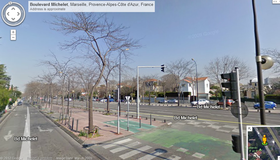
One of the blogs I follow is "Stroad to Boulevard", run by a Vancouverite. It documents how the difference between what Strong Towns' Charles Marohn calls stroads (and Pedestrian Observations' Alon Levy wide boulevards) and traditional European boulevards is merely one of priorities. Looking through recent posts, I noticed something interesting about where he chose to plant his link to Marseille's Bvld. Michelet here.

Can you find it?

If you can, and you comment, you, good sir, win One Free Internets! Huzzah!

Tuesday, November 6, 2012

A Pocket Park on Market East?

The St. Stephen's Square proposal for 10th and Market
Market East is at a crossroads.

PREIT has bought out the former Gimbels at 901 Market--the one that's now a Kmart; the original Gimbels, where the Disney Hole now sits, was torn down some 30 years ago--from Vornado, and is rumored to be planning on a $300 million renovation--though investor documents make one worry they're going to beg for government handouts first (for whatever reason). Meanwhile, the 1000 block of Market offers two distinct, and opposing, directions for the area to take.

The first is the the new Marshall's, whose design makes it feel a tad smaller than it really is, but which has a wide array of merchandise in stock. Marshall's tends to be something of a fixture in stronger downtowns. The other is a new Lot Stores in the old Valu-Plus; Lot Stores are notoriously ultra-low-end, and represent the continuing inertia of the area as hands wring, companies beg for money, and bloggers and people in general complain about how the retail there really should be an order of magnitude better.

The hope is, with the Girard Square proposal and Gallery redevelopment, Market East will begin to firmly improve itself. With oodles of retail space available, it can successfully cater to the Great Middle--the big boxes, mall chains, and so on--but to do that, it needs to have people dedicated to that vision constantly working on it.

Anyway, now that I've written myself into a corner, I'm segueing (somehow) to an idea I've been kicking around for the commercial part of the 900 block of Market: a pocket park, a public gathering space at the corner of 10th and Market, where "Center City's Main Street" and the City's Main Street meet. The idea is like Toronto's Dundas Square at the corner of Yonge and Dundas: a small public space as a gateway, and a more formal and gracious addressing of one of eastern Center City's main intersections.

Aside from Dundas Square, inspirations are: Herald Square, New York; Union Square, San Francisco; Pioneer Square, Portland; Westlake Park, Seattle; and Phillips Square, Montréal. All of these are retail areas defined by a public park, which has a varying degree of "green-ness" as well as average market affluence: a J.C. Penney prominently heralds Herald Square along with Macy's, and Dundas Square's main anchor is a Sears (of all things), but Nordstrom is a major anchor of Pioneer Place (the square, not the mall) and Saks sits prominently along Union Square. Also note that, on occasion, a church has pride of place--St. Phillips is one of Phillips Square's major landmarks, for instance.

In fact, St. Stephen's Church provides a high-quality side façade which helps mark a square at 10th and Market as a place, and offers it an intuitive name: St. Stephen's Square. It also gives the Lantern Theater Company a welcome front door (so to speak).

And it also offers a platform for redevelopment on two adjacent parcels: 920 Market is currently a sorry two-story structure, but the lot is large enough, and the site prominent enough, for something far denser; the same can be said for 1000 Market. It also affects both halves of the Gallery as well as 901 Market, helping to make the corridor a little more desirable.

And, like it or not, 10th and Market is a far more effective corner for such a space than 8th and Market, surprisingly out of the way.

Monday, November 5, 2012

Pursuing BRT in the City Branch

The Planning Commission has decided to pursue BRT in the City Branch. The importance of this route as a transit linkage was identified in the Philadelphia2035 Comprehensive Plan; its implementation is a natural element of the Center City regional plan.

The decision to pursue BRT is being said to be due to cost: the claim is that light rail would cost some 3x more than the BRT (which is being priced at $75 million). That this is debatable is already well-known here, especially since the BRT proposal being floated in this plan involves buying special equipment, one of the primary cost drivers of the light rail proposal.

Remember, the engineering and the subroadbed are already sunk costs in the City Branch. This means that the primary costs for light rail are (a) rails, (b) trains, and (c) electrification (if desired). (See update below.) If the City Branch LRT purchase were to be rolled into SEPTA's inevitable replacement of the Subway-Surface Kawasakis in the near future, cost (b) would be eliminated from the current proposal, but at the price of needing to wait until the new equipment order for the, well, equipment. The costs for BRT, by contrast, are (a) pavement, and (in the City's proposal) (b) buses. This means that the primary cost difference is the cost of electrification, and that, therefore, the City's implied claim that light rail would cost $225 million is fallacious.

That said, BRT has two clear advantages, at least in the near term, over any rail proposal.

The first is obvious. Both the light rail and the light metro proposal were greatly handicapped by length. The "natural" light rail alignment is from 40th and Girard to 11th and Bainbridge via Girard, the City Branch, and 11th/12th; the light metro ran in the branch from Girard to 13th, where it segued into a new cutoff tunnel linking it with the existing Ridge Spur at Noble. Neither would have been longer than three or four miles--nowhere near enough to develop a full line's worth of ridership.

The second is a little less intuitive, particularly with the masking effects the specialized equipment provides: this is that the City Branch can act as a funnel for routes to the north and northwest, much as Woodland Ave. and the trolley tunnel that subsequently replaced it act as a funnel for routes to the south and southwest; the Branch's outlet is also such that routes can subsequently fan out to cover a broader swath of Center City destinations than any rail proposal.

To that end, I propose a 2.5 route system maximized for frequency, and thus ridership.

The first route is the 32, routed into the City Branch instead of the circuitous alignment it has through Fairmount, improving travel time by 5 or 10 minutes. It would run on a 15 (preferably) or 20 minute headway throughout the day, and degrade to 30 minutes after 9:00 or so.

The second route, which I am calling the x40, is a heavy modification of the current Cultural Corridor BRT proposal: Where the current proposal is merely planned to pass by cultural destinations, to the detriment of ridership, I extend it to St. Joe's to tap the Main Line's ridership potential, and twist it down to a Chestnut/Walnut alignment to Penn's Landing to hit eastern Center City's main employment centers: Penn and Jeff Hospitals and the offices around Independence Mall. (Penn's Landing, by the way, is little more than a convenient bus terminus.) Like the 32, this route would run 15- or 20-minute frequencies.

This ensures that a bus passes along the Branch every 7.5-10 minutes, frequent enough to say one will be along shortly.

Finally, the half-route would be the 27, which would be routed off the Schuylkill at Girard and onto this route at peak periods, when the Vine is a zoo. It would run express through this alignment, the shaved minutes more than enough to pay off waiting at the lights as it traverses Girard between the Branch's terminus and the Schuylkill Expressway.

A last element: at my table somebody suggested moving the Phlash to the Branch, which was echoed and supported by the planner at the table--indeed, it appears to be a major reason the City is pursuing the project. The way I understand it, the Cultural Corridor proposal (my emended x40) is proposed to supplant the Phlash, not supplement it; part of the idea is that the City Branch offers a convenient replacement to Parkway bus routes. This presents a problem w/r/t the 38, whose Mantua coverage element would be eliminated by a Branch move, but not for the other routes. It may be better to pursue a surface Pennsylvania Ave. alignment instead for this route instead, as its main ridership base resides in Mantua.

UPDATE: Since several people seem confused by my line of reasoning involving equipment procurement, let me explain it this way. (1) The City's current City Branch proposal involves procuring equipment specific to it. (2) Costs for buses and light railcars in this situation are relatively equivalent (buses cost less, but for the type being proposed, not by an order of magnitude). (3) The City claims the BRT proposal is 1/3 the cost of light rail. (4) (Assuming the light rail would be electrified) this implies the primary cost difference between the two is electrification. (5) The City's BRT price quote is $75 million. (6) That implies the cost of electrification, according to the City, is $150 million. (7) I find that doubtful; the needed electrification would be able to piggyback off of the (active) 15 and (dormant) 23 networks, largely, if not completely, already in place.

So the problem I'm having is that the City is trying to have its cake and eat it too. For the City to believably claim that BRT is 1/3 less than light rail, the BRT cost would have to be limited to just the busway. In the current proposal, it's not.

I think I attempted the original (and yes, tortured) line of reasoning to approach this issue another way--by finding a way to equivocate equipment purchases--in that attempt, by tying equipment purchases for this project to SEPTA's impending trolleycar replacement.

By the way, if it's not already obvious, my major reasons for support of the BRT proposal here are because of the brevity of the ROW being discussed, and because BRT does offer superior alignment and routing options per x unit of capital (not operating) cost.

Wednesday, October 31, 2012

An Emergent Main Street?

Something interesting is happening in the village of Lafayette Hill. A Main Street is coming to be.

This, despite the majority of this Main Street consists of mid-century strip malls and commercial pads. It's a Main Street in use, though decidedly not form. Take a look.
It runs like this from Joshua Road to Church Lane.

But, since the buildings are aging, the majority of chains have moved out, to newer, shinier digs around the Plymouth Meeting Mall. In their place are more locally-owned stores, more boutiques, more inns, and what are generally considered the two best Persian cuisine joints in the region.
Lafayette Hill is the overgrown agglomeration of two older villages: Barren Hill and Marble Hall, which has led to its bipolar development and a small gap in the middle. But the density, the connectivity, the ingredients are all there--and, as the buildings age and rents come down, the more interesting uses, too.
Which leads to the greatest problem in front of Lafayette Hill: its very autocentrism. Strip malls don't create a pedestrian atmosphere, and despite the fact that it's the same size as e.g. Lansdale, walking rates are much, much lower. So what's to be done?

Brand it. Give it a "Main Street Lafayette Hill" identity; play upon its existing strengths. Have a citizens' day; take over a parking lot and use it for a farmer's market; install sidewalks all the way up and down. Make de jure the de facto parallel parking already in front of the Wawa and extend it all the way up and down Germantown.

And in the long term, change the zoning code to remove setbacks and favor rear parking*. Curb minimums, and encourage walking plans for the bars. Preserve the Manayunk vernacular and Victorian buildings already here, of which there are a few. And allow structures to grow to 3-5 stories.
___________
* Transit access is relatively poor, unlike Conshy or Paoli or Lansdale.

Tuesday, October 30, 2012

A Provincial "Provence"

The North Broad casino proposal, the "Provence".
Late last week, just before Sandy's wrath broke over the Northeast, Bart Blatstein unveiled his proposed North Broad mega-casino and resort, the Provence, to local politicos, powerbrokers, and the press. Ambitious in scale, it is nonetheless relatively unambitious in amenity, seeking to replicate a Vegas Strip-type development on North Broad. And as such, an introverted design seeking to lure customers in and up, rather than one seeking to connect what is currently a relatively empty area between Center City and several major neighborhoods, it falls prey to significant urban design and architectural failings.

In the past, Blatstein has shown he does not truly grok urbanism, but that he can be coached by those who do to produce intensely-urban designs; the Piazza, generally considered his greatest success, began life as a strip mall design like his movie theaters on the Waterfront and in Manayunk: it was gradually coached into its final form as a collaboration between he, the developer; Scott Erdy, lead architect of Erdy-McHenry; and Matt Rubin et al. of the Northern Liberties Neighbors Association. As neither Blatstein nor Erdy are natural urbanists*, we can safely say the Piazza's urban design is largely the NLNA's work.
Blatstein did not produce this by himself.
The fact that Blatstein has learned more a facsimile than a reality of the Piazza's lessons shows in the Provence. It has not one, but several notable urban design issues, which, taken together, fail to capitalize on the site's existing assets, and worse, fail to ensure strength beyond a single life-cycle.

Where to begin...? Let's head west, beginning with the Inquirer building, the structure that dominates the 1400 block of Callowhill. Considering only the 1920s structure**, the section Blatstein owns, it has two wings: the office tower, facing Broad, and the printing house, slung long along Callowhill. Blatstein proposes turning the office tower into a hotel and the printing house into a parking garage.

Were this the lone element of the project, or a phased approach, fine. But it's neither, it isolates the hotel from the entertainment center proper on the 1500 block of Callowhill, and it's a poor use of the second-most-valuable historic resource on the site...
Instead of "rooftop retail", why not repurpose the printing house into a shopping center, like the Stary Browar?
 If Blatstein wants retail, why not put the retail in the printing house? It's already long, low-slung, and marked by a natural concourse, for such are the demands of printing machines; it connects North Broad with the entertainment complex, rather than separating them like the garage does; it would be a truly unique and unusual retail amenity--the only comparison I can think of is Poznan, Poland's Old Brewery.

This allows, secondly, the jettisoning of the "rooftop retail", the proposal's current attempt to be new, and unique, and different. It instead looks trite, clichéd, exurban. It reminds me less of Aix-en-Bains and more of Exton. The rooftop can then become a green roof and a place to put entertainment functions, particularly the mainstream bookings that more natural for a proposal of this nature.

This proposal also needs to compromise between casino operators' demand for windowless main gaming floors and neighbors' reasonable demand for an active streetscape. To do this, the casino's two main restaurants (casinos of this size always have at least two restaurants) are stacked above and below the main gaming floor(s), giving one restaurant killer skyline views, and the other, a killer streetscape to lure patrons in. In this way, the lower restaurant itself becomes a casino entrance.

The skybridge is, unfortunately, in many ways inevitable. However, it is entirely possible to design to blend it in, unlike the current proposal, which would essentially turn it into a barrier overpowering 15th: Seattle's Convention Trade Center shows us how. The Provence's current skybridge design fails in all respects: instead of making the bridge as transparent as possible, it instead turns it into a giant billboard advertising its presence all the way from City Hall, and the resultant stretch of 15th underneath is lined with blank walls: a commandeering, demeaning streetscape, and a natural bum bathroom. Instead, the skybridge can function as a glassy, light-infused critical linkage between the casino, retail atrium, and entertainment-focused rooftop.

The proposal also seeks to convert the underutilized 1500 block of Vine--a block quadrifurcated by the Vine Street Expressway on- and off-ramps into a large park. This is folly: the block would not be one square, but four disassembled parks. Logan Square already suffers from this problem, and it takes a high degree of passive and active programming to keep its Sister Cities Park wedge from ending up like its Shakespeare Park wedge--a bum magnet. With all its functions introverted, can we really expect the casino to program to the degree needed to ensure activity? No: better to allow the undevelopable northern sliver, along Callowhill, to pass into passive use, and the three remaining sections to become developable sites as Franklin Town slowly fills in.

The majority of the site's parking is to be structured, and fronting 16th; shifting the spaces the Inky printing house garage to this side is the next major element. To do this, why not sink some parking under the casino? More expensive, yes, but as Blatstein has already proved, expense is no object. Some more spaces could then be placed to the side of the casino proper.

And, of course, to ensure the pedestrian usability of 16th, active street uses are still needed. Lying between the Community College and the casino, this would be a great place for support retail functions: lunch counters, noodle houses, diners, used book, vinyl, and photography stores, a branch of Zavelle's, and so on. It would also be wise to repurpose the first floor of the 1601 Callowhill garage into at least two retail spaces (one at the 16th and Callowhill corner and the other at 17th and Callowhill), for larger convenience stores and pharmacies, such as Wawa and Walgreen's. Again, this is the support area; the carriage retail area is the section in the Inky printing house.

...This brings up another important retail issue. For this proposal to be successful without being detrimental to the city at large, it cannot suck from Walnut, or Chestnut, or Market East. It must offer something different, but something that complements these places. It would need to be able to compete successfully with Cherry Hill and King of Prussia, particularly for traders who tend to favor mall environments anyway. Again, it cannot merely achieve success by downgrading Walnut--that would be bad for the city at large.

The ninth, and final, issue is with the casino itself. I'm ambivalent about casinos in general, more swayed by CasiNo than FACT, but for the complex to succeed, the casino has to be a destination, and not just feed off the lowest common denominator. It is very easy for a complex of this nature to devolve into a tired Trump Taj Mahal whose retail's dominated by parasitic "internet cafés", gambling dens whose entire business model is predicated upon regulatory loophole abuse. Maintaining a high quality at this complex requires time, energy, dedication, and good urbanism to ensure easy retention and recruiting.

This final thought is necessary even without the casino element; a strong, well-designed center can thrive without it, converting the casino space into something different (like a movie theater); poorly designed, the complex begins to totter and fail.

Should Blatstein listen to coaching and advice, we can jettison the "Provence" name, and instead adopt a grittier, more industrial-chic name. The Old Printing House comes to mind.

EDIT: Find updates in comments below!
_______________
* An inveterate Corbusierian, Erdy's attempts at urban planning are some forty years obsolete. He is at his best designing for an individual site (cf. the Radian) rather than an agglomeration of sites, the scale urban design works at.
** The later, northern wing, often called the Daily News Building, is home to the School District's offices.