Showing posts with label engineering. Show all posts

Monday, September 29, 2014

Kansas City Can Do It Better

(This post started as a fork from the previous post, The Streetcar Fiasco.)

Let us recall, for reference,  Width, and the Perception of Width and Multiway Boulevards, Transit Avenues.

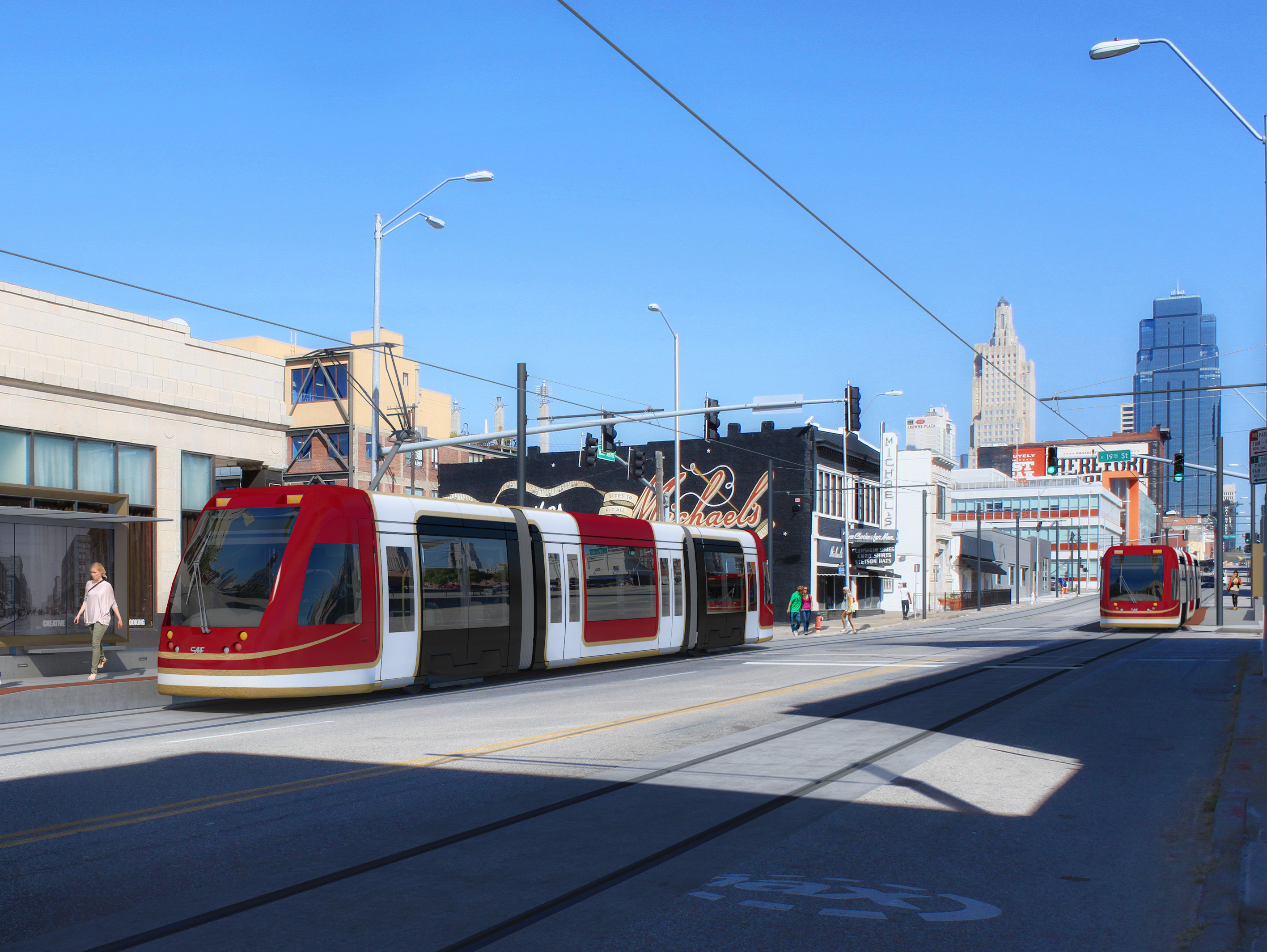
Kansas City Streetcar render
Kansas City's Main Street is only 80 feet wide -- 10 feet narrower than H Street -- but has nothing like the latter's congestion. Yet there are two southbound lanes and one northbound lane, and during "peak" periods the parking lanes turn into bus lanes. The streetcar is a mere drag-and-drop effort into the existing system.
The narrowest a street can be and still have full light rail is a mere 70 feet. At this width, several compromises have to be made, sure -- in particular, on blocks hosting stops, parking lanes need to be removed -- but they are as nothing compared to the scale of the compromises that need to be made on
60-foot streets. And remember, Kansas City's Main Street is a -- measured -- 80 feet wide.
Sample (pre-Streetmix) sections
In fact, we can have our cake here and eat it too. The nature of Kansas City's layout allows us to route core bike infrastructure on Broadway Boulevard and Grand Boulevard, which gives Main Street plenty of room to handle all of light rail's needs. Like so (with a parking space where the stop isn't).
A second option would be to kill parking spaces on one side of the street. It may be preferable to construct a street layout like this between stops. (Note that, in this layout, the parking space may also be claimed as a parklet where sufficient pedestrian energy to do so exists.)
In both, however, it becomes evident there is plenty of space for proper light rail, instead of copying a failed experiment from elsewhere in the country. More creative thinking's all that's needed.

Well, that, and a willingness to give up traffic lanes.

Friday, September 26, 2014

The Streetcar Fiasco

Streetcars have become a major fad over the past few years, ever since Portland put in theirs.
Portland Streetcar
In Portland's case, the streetcar is a pretty decent investment: it acts as a circulator overlay on a high-quality light rail system. But after they put theirs in a bunch of other cities began to construct streetcars for themselves.
H Street Line, Washington, DC
DC's H Street line was the second major streetcar; it is also the first that suggested an underlying problem. You see, H Street is supposed to be a spine corridor, linking the city's east side with its west. It thus needs to be built to a higher standard capacity than ... that.
This particular design -- at the time, novel* -- contains two catastrophic mistakes that permanently mar this line's capacity:
  1. The line has been built in a mixed traffic lane rather than be given its own dedicated lane. This reduces the streetcar's speed and makes it no better than a bigger bus on rails. Part of what makes light rail successful** is the dedicated lane. Without this lane the line is unable to bypass car congestion and thus provide the positive time differential that helped justify e.g. Salt Lake's investment.
  2. The line has been built in the outer lane. This second point makes it own strange kind of sense -- once you've decided not to build a dedicated ROW, there's something vaguely suicidal about asking passengers to run across a traffic lane unless you're willing to put carstops in, and if you're doing curb bumpouts as well, then why not put those there? However -- by putting the streetcar track in the outer lane you create conflicts between the streetcar and parallel parkers, delaying the transit vehicle for a single driver. These kinds of conflicts slow down vehicles on our country's remaining historic streetcar lines all the time -- one of the reasons Boston's Green Line is one of the most reliable is because (unlike the examples in Philly, Toronto, and San Francisco) the vast majority of the surface system lies in dedicated medians.
H Street was a difficult design challenge. The street is, surprisingly, 90 feet wide, and it is fairly congested -- its AADT hovers a little above the max capacity of a two-lane street -- and a full light-rail buildout would have likely required (among other things) taking of a parking lane significant street reconfiguration, much like 1st Street in San José, a bright spot in the VTA system.
1st Street, San José
Indeed, it is arguable that the H Street Line's optimal placement would have been for the light rail to lie between the sidewalk and the parking lanes, with a road diet reducing auto capacity just enough to convince (some) drivers to Take Other Routes. This arrangement, however, remains problematic in its own right, and is not the thrust of this post -- and I have talked about these kinds of things before.
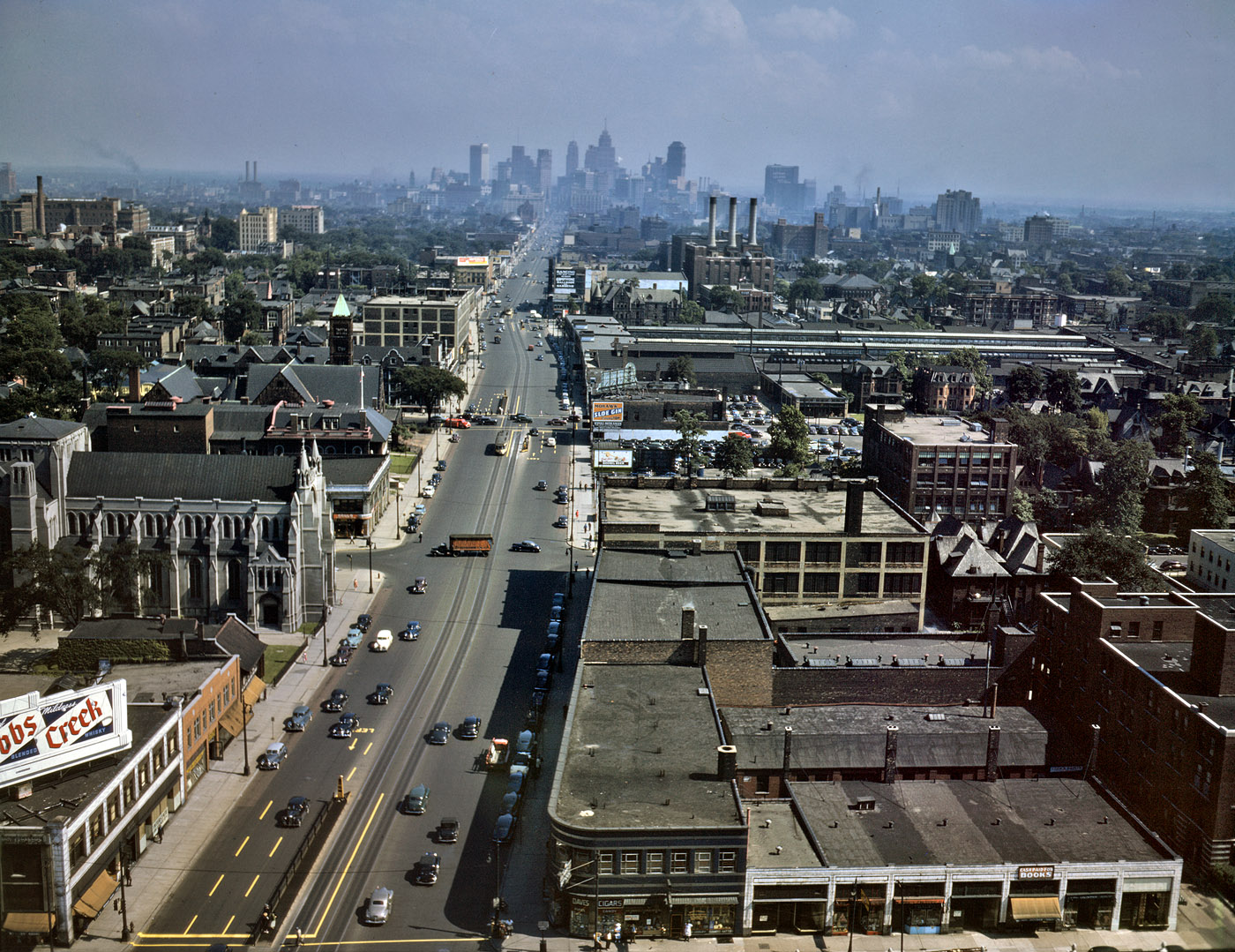
Woodward Avenue, ca. 1942. Note that even then there was little real congestion.
M-1 Streetcar plan reveals same engineering failures as H Street -- this time, with even less excuse.
At least two Midwestern cities have taken the (failed) H Street approach and applied it to themselves: Detroit and Kansas City. I haven't been to Detroit, but I will note that Woodward Avenue, which is eye-poppingly wide relative to traffic, can easily accommodate every single mode, if the designers chose to.
Kansas City Streetcar render
What is perhaps most shameful is that within these ... things ... lies the fact that the powers-that-be continue to refuse to give up any street space for cars, no matter how ridiculous the car gluttony may be *cough cough Detroit, Kansas City cough cough*, and are packaging it as a political sop to Millennials.

No. The transportation investment that would please us the most is in quality bike infrastructure. We want to ride around everywhere. Bike-friendly cities are Millennials' cities.
____________
* Portland's downtown streets are only 40 feet wide; historic streetcars ran in the middle of the street. (See, for example, Philly's trolleys.)
** And good BRT -- Cleveland's Euclid Avenue being the only such example in the United States today.

Wednesday, March 19, 2014

That Eureka Moment

One of my long-term projects has been developing a mathematical model for scheduling in Jarrett Walker-type transit systems. Today, I made a breakthrough--

I had previously realized that a model of such a system would yield two intersecting planes in my defined 3-space, and that desired overall frequencies could be model by stacking instances of these planes atop each other. But I'd been at a loss as to how to model the routes within the planes (other than the fact that they were vectors).

What I realized today, however, is that the planes are actually a set of null space vectors; this means that a prescribed eigenvalue in the null space will seed an eigenvector that corresponds to that value. What that means is that the entire system can be modeled with nothing more than the equations of the two intersecting planes, and the set of eigenvalues that yield the eigenvectors corresponding to the known bus routes.

Fortunately, we remain in vector space so far, but it appears the apparatus I'm constructing will wind up generalizing into a differential equation, to accommodate "gridlike" systems which attempt to install a mass transit grid even over non-grid street networks.

Wednesday, December 18, 2013

The Forgiving Design Hierarchy

While this post started as a fork from Compromises on North Broad, it is really a topic unto itself, and a core post of my thinking on how design affects safety. I am calling it (in draft) the forgiving design hierarchy concept of street design workflow. I hope that, as you read, the reasons will become clear.

Hierarchy

The key is attaining a tradeoff--a balance of priorities. To do this we need some sort of hierarchical modal evaluation criteria. This could be easily abused and turned into a checklist by the same kinds of numbnuts who eviscerated any pretense of urbanism in Syracuse, but having such a checklist exist, and be public knowledge, would be an invaluable tool in project evaluation and project criticism. For a street--a value-creation platform--modal consideration would progress
  • Pedestrians
  • Cyclists
  • Dedicated Mass Transit (if applicable)
  • Motorized Transport
in that order. This is tied to an underlying principle that design consideration scales with modal vulnerability--that is, the more vulnerable a given user is, the greater the design consideration for them should be. This, of course, does not preclude high-quality facilities for the dominant (and in road situations, usually the only) mode of travel; rather, it merely states that first attention should be given to a facility's most vulnerable users. This does not really affect the layout of true roads at all; indeed, it subtly enforces the road/street division in transport hierarchy.

The Role of Forgiving Design
What we call "forgiving design" is the set of auto-oriented transportation engineering design guidelines that first emerged with the initial construction of the Interstates. It is an extension of rural design standards, applied with the idea that such standards would improve speed and flow in urban areas. That it is should surprise no one: as I have just pointed out, even in my revised system, most rural byways would stand unaltered. Unfortunately, urban areas, busier and more congested (both good and bad), are hence more incident-prone. The problem is, of course, that current forgiving design principles have proven to be a failure at increasing safety in urban areas--and, even worse, have proven to be a disaster from a safety standpoint in suburban areas (cf. Dumbaugh and Li).

Subjective Safety

Key to the performance of the Dutch cycling network is a concept called subjective safety, the realization that, when it comes to driving usership, the perception of safety is just as important as what is, statistically, "safe". So the optimal approach to generating the prioritization hierarchy above would seem to be to implement subjective safety principles across the more vulnerable modes, fitting forgiving design for automobiles in where it can fit (precisely the opposite of our current approach, which fits in infrastructure where it can fit after the cars are designed in). But--at least in London--subjective safety and forgiving design appear locked in battle, with TfL's flow needs trumping subjective safety needs, despite the lobbying of numerous cycling-advocacy organizations.

Two Sides of the Same Coin

But the principles of subjective safety are the principles of forgiving design--just applied to a different mode. The whole point of subjective safety, the perception of safety, is achieved by creating an environment forgiving of error; the whole point of forgiving design is an environment forgiving of driver error. This intermodal mesh drives the British conflict: on London's limited road space, who gets the space allocation they need for their approach? Who "wins"? Are they the drivers, accommodated by forgiving design, or the cyclists, accommodated by subjective safety? But it doesn't have to be this way: understanding that they are one and the same allows us to integrate the two elements--forgiving design and prioritization hierarchy--into a single model.

Upshot

Subjective safety and forgiving design, now revealed to be one and the same thing, merely tell us how to design safe* infrastructure for a particular mode. But our world is multimodal. To answer the question of which mode gets priority, the hierarchy, increasing attention for increasing vulnerability, yields the answer. Hence the framework which I am proposing, and wish to investigate further, is one where we
  1. Consider a given route. Consider factors such as existing usership(s), current population density, planned population density, distance/mode optimization, origin/destination proximity, etc., to model usership. For roads, none of this matters. But roads also cannot have curb cuts.
  2. Design for each user in turn of vulnerability.
  3. For each mode, apply forgiving design concepts. For places with low pedestrian volume, but increasing bike volume, for example, a multi-use trail will work.
  4. Evaluate whether or not the tax base can support the design. If not, reduce until within this "solvency envelope".
which is, of course, largely alien to current transportation engineering workflows.

Further Questions

This is just a framework. Many unanswered questions within this framework remain, such as what minimum adequate forgiving design for each mode would be, what optimal infrastructure in several contexts would look like, and even the whole question of designing for enduring financial solvency. In fact, this framework is the core of the research I wish to pursue, largely because I find myself convinced this is the right approach and would like to see it applied and further refined--but as it stands, it is hardly ready-to-go as a framework, and is rather much more conceptual.
_________________
* With certain exceptions, e.g. suburban arterials, where forgiving design appears powerless against an even more foundational foe, the curb cut.

Tuesday, December 17, 2013

Compromises on North Broad

Jon Geeting recently picked up on an implicit idea in my Width, and the Perception of Width article: giving Broad Street the same design standard as e.g. Paris' Ave. Kléber. He has also run further with this idea than I ever conceived, including the idea of putting a BRT lane down Broad. While these are all good ideas in their own right, however, at a certain point Broad Street--especially North Broad--will demand, at a certain level, compromise.

The reason for this is a legacy of highway projects that never got built, particularly in the northern suburbs. While this is, as Alon Levy pointed out, good for mass transit (and a major reason why reactivations of the Newtown Branch and Bethlehem Branch (at least as far as Quakertown) are good ideas), it does impose a certain stark reality on Broad Street.
The 309 (blue) and 611 (red) corridors both feed into North Broad.
Both of the major highways serving the northern suburbs--PA-611 and PA-309--drain onto North Broad. Because of this, much of the traffic into Center City from central Bucks and Montgomery Counties comes down North Broad: while the Northeast Corridor May function as an escape valve, it only serves a small portion of the northwest corner of this area; commuters from Ambler, Doylestown, Flowertown, Glenside, Hatboro, Jenkintown, Warminster, or Willow Grove have little choice other than SEPTA or North Broad. And of course, commuters from (especially) Churchville and Richboro have none. This makes North Broad's demand far higher than South Broad's, one of the reasons why the current traffic pattern involves converting a parking lane into a through lane at peak.

This raises the difficulty that, while an MWB would be easy to implement on South Broad, it is somewhat more difficult on North Broad. While it certainly offers significant traffic calming and safety improvements, it doesn't really address flow interruption congestion (congestion caused by traffic lights), which the peak fifth lane functions as a band-aid for; implementing it as a reversible lane would  (a) make it quite difficult to fit everything else onto the street, in addition to being (b) quite ugly. And of course, the real solution to the flow problem--eliminating traffic lights--would be catastrophic for all other users. All of this implies that North Broad requires, at minimum, four through lanes with good light timing minimizing stops, which, of course, dashes any hope of BRT on the corridor. (Not that the 4 or 16, with the subway underneath, really need it.) That said, BRT would be useful on several other corridors, such as Erie, Allegheny, Lehigh, and Washington Aves. BRT could be run down the less busy South Broad corridor, but it is, if anything, even less useful there (cf. Reading Between the Lines).

So the key is attaining a tradeoff--a balance of priorities. To do this we need some sort of hierarchical modal evaluation criteria. This could be easily abused and turned into a checklist by the same kinds of numbnuts who eviscerated any pretense of urbanism in Syracuse, but having such a checklist exist, and be public knowledge, would be an invaluable tool in project evaluation and project criticism. But what would this entail? To see my answer, partitioned from this post due to increasing lengthiness (not that that's stopped me before) and as subject matter deserving its own post--stay tuned.

Thursday, December 13, 2012

Multiway Boulevards, Transit Avenues

Stroad to Boulevard is a blog dedicated to a single policy recommendation: the replacement of American-style arterial avenues (aka stroads aka wide boulevards) with multi-way boulevards, with examples mainly drawn from the French style. This is justified primarily by economic gardening: stroads fail, according to Strong Towns' Charles Marohn, to create places of value (i.e. offering a public environment nurturing of true value-creating enterprise over life cycles). In addition, the benefits of urban greenery are obvious, and (as Stroad to Boulevard's author points out) benefit congestion by decoupling through traffic from causes of friction, after Jarrett Walker.

Multi-way boulevards appear endemic to places of value in Europe, and rudimentary versions even occur in places of high value in the United States--see, for example, Commonwealth Avenue, Park Avenue, and K Street--but they have yet to be accepted here. Part of this is due to different focuses in transportation planning, engineering, and design: in Europe, a more multi-modal approach became more accepted and, yes, welcomed after the Dutch bike revolution, whereas in the United States the moving-cars-around orthodoxy continued to prevail. In essence, this means American transportation engineering is now a generation behind Europe's.

What I want to explore now are two things: firstly, the variety of configurations available for such boulevards, and secondly, ways to implement transit in the scheme.

What is the Minimum Width?
Stroad to Boulevard carries, essentially, a single cross-section, seen above, for a typical boulevard--100 feet. Of this, two access ways (curbside woonerven) flank a four-lane central artery. Each access way is 28 feet, and the central artery 44 feet, which implies that each driving lane is 11 feet. It is possible to tweak some of the design features--for instance, dropping a foot off each of the central passing lanes (not meant for trucks anyway) and adding it to the access lanes. As woonerven, the access area fulfills primary pedestrian and cyclist needs and secondary auto ones (primarily loading and parking)--to function, in other words, as a street--while the central artery is able to function as a road.

We'll call this full profile--bidirectional, with twin woonerven. It is intuitive that this would be optimal for 100-foot arteries, such as Broad and Market streets.
Ignore the school bus. There would be no bus lanes at this standard.
The narrowest a full-profile multi-way boulevard could be would have two driving lanes in the center, flanked by woonerven on either side; this is created by removing the 100-footer's inner passing lanes. Taking 28 foot as the standard woonerf width, this implies that the narrowest full-profile multi-way boulevard must be 76 feet--that is, (28*2)+(10*2). Since few (if any) American streets are exactly 76 feet wide, this implies that 80 feet is the smallest practicable limit, which we would fill out by adding a foot to both driving lanes and each access lane--(29*2)+(11*2).

If you split this in two, you would get a half-profile boulevard. The narrowest this could be would be 38 feet (or a more comfortable 40 feet)--assuming no pedestrian realm at all to one side. Add a sidewalk and you've got 50 feet.
The problem with this, however, is that most nearly every 50-ft street is a street, and thus not compatible with the MWB treatment. Even Paris' Boulevard Haussmann is a street. In fact, I do not believe there are any half-profile boulevards in existence--they gobble too much space with their access woonerven, provide inadequate parking relative to their full-street counterparts, and most 50-ft streets offer ample natural pedestrian realms--almost a 1:1 sidewalk/street ratio as long as the carriageway is held to reasonable widths (that is a ten-foot driving lane plus two eight-foot parking lanes, for 26 feet total).

So we can say the narrowest useful multi-way boulevard is 80 feet. This actually works well for most American cities, which tend to have wider streets that can better support this treatment.

Adding Transit to the Scheme
Most European multi-way boulevards have buses running in the outer through lanes, and some have  light rail in the median--see this example from Rotterdam. Such boulevards can have truly tremendous widths--Rotterdam's Schiekade looks to be, for example, some 160 feet wide--but we are focused on developing light rail along boulevards of more manageable width.
Girard Avenue is a good example: The 15 trolley runs in the median of what is here a 120-foot street. This represents an easy insertion into the 100-foot multi-way boulevard standard--see above. Likewise, a transit median on a 100-foot multiway boulevard, like would be a relatively simple insertion into the 80-foot standard--see below. Washington Ave. would be a good possibility for this treatment--see below.
The problem comes when you need to put a transit median into an 80-foot way, like Baltimore Avenue. Without the trolley median, it would be equivalent to 60 feet, too narrow for a full boulevard. Could a sacrifice need be made? Just the woonerven--Stroad to Boulevard shows us the way. While that post is about 66-foot streets, a crop of three feet on both sides brings us down to 60 feet, enough to insert the 20-foot transit median in between. This is, again, perfectly encapsulated in Rotterdam, on the Middellandstraat:

 Even where the street is too narrow to support full access woonerven, it's still possible to support a transit median. But what about 60-foot streets, like Germantown Avenue? This final class does require a sacrifice--Do you give mass transit a dedicated right-of-way and cut parking? Or do you mix traffic in two travel lanes and provide it? Both solutions require a tradeoff: with the former you have better throughput on all modes, but most constituencies demand parking and reject any proposal reducing it, Shoup be damned.

So in conclusion, we can say that, firstly, the nature of a multi-way boulevard makes 76 ft. its absolute minimum, as that width has two driving lanes coupled with mirrored woonerven; this can be retranslated into an 80-foot standard for most American municipalities; secondly, that the addition of transit lanes blows the width out a bit, and that a 100-foot transit boulevard is analogous to an 80-foot multi-way boulevard, 120 to 100, and so forth; thirdly, that transit provision on sub-100-foot streets requires a transit avenue, built like a Dutch complete street; and fourthly, that at 60 feet a tradeoff must be made between throughput and parking.

While this post is by no means perfect, consider it a framework for applying transportation engineering and urban design to the streetscape; consider it a framework for implementing European design standards in American situations.

Monday, September 24, 2012

Easy, Medium, Hard

Flourtown. Jenkintown. Ardmore. What do all these places have in common?

They're all four-lane Main Streets in rights-of-way really too narrow to handle them. Too much of the right-of-way is dedicated to making through traffic move fast; too little to ensuring good pedestrian movement. Each of these Main Streets is a historic Main Street with average or above-average place intensity; in each, there is no good reason to sacrifice parking and sidewalk for traffic lanes.

Let's start with Flourtown. Built as a linear village sprawling along Bethlehem Pike, it stretches (and has stretched for at least 150 years) through Springfield Township--its primarily population concentration--from Chestnut Hill to Whitemarsh. It is subdivided into three sections: Erdenheim and Valley Green bookend Flourtown proper.

Now, tell me why on earth is this stretch of Bethlehem Pike four lanes? Certainly, it used to be the south end of the main trade route from Philadelphia to the Lehigh Valley--which is why Flourtown grew in the first place--but that function has since been bypassed by the Fort Washington Expressway, which connects rather into Cheltenham and Ogontz some miles off. A suburban extension of Chestnut Hill, Bethlehem Pike in Flourtown functions as a natural Main Street, albeit one cut in several places by strip malls, and never gets the kind of traffic four lanes should demand. Indeed, in a spontaneous experiment, Aqua has been repairing water pipes under the street, which has halved effective capacity, without inducing onerous traffic conditions.

Its through-road capabilities diminished, it is apparent this stretch of Bethlehem Pike needs instead to capitalize on placemaking to help further develop Flourtown. This can be done by simply getting rid of the two extraneous lanes, narrowing them to parking lanes, and in the four-feet-a-side of added space run either (a) a bike lane, or (better) (b) expand the sidewalk.

If Flourtown was easy, Jenkintown is harder. PA-611 runs along its Main Street, Old York Road, which (due to the region's underbuilt highway system) is the main artery from Philadelphia to points north. Old York Road links Broad Street with Easton Road, the long-distance pike, and is as such still very much a key trade route.

But it is not an insurmountable problem. Like Ambler, Jenkintown is enough a place to hold its own without through traffic--traffic that usually stops not on Main Street, but rather in strip malls beyond (in this case, primarily Willow Grove to Noble). And Easton Road is reasonably straight and meets the city at Cheltenham-Ogontz, allowing 611 traffic use of (very) wide Cheltenham Ave. to Broad St.

...Unfortunately, this passes through downtown Glenside and Roslyn. If the point is to bypass downtown, what use is it to simply bypass one downtown for another? A better route between the two would be Rices Mill Road-Highland Avenue, which would thread between Wyncote and Glenside.

The hardest is dealing with Lancaster Pike, Ardmore's Main Street, in a situation like 611, but with more downtowns still--this would also involve a bypass of Bryn Mawr.

The reason this is more difficult is because of the nature of the Main Line, and because no useful bypass exists for Wayne or Paoli further up. Regardless, a feasible bypass begins at Villanova, and follows Spring Mill Rd. to Montgomery Ave. This route follows Old Lancaster Pike to 54th St., a better one would follow Wynnewood Ave./Rd. back to Lancaster Pike by Lankenau, sucessfully bypassing the heart of the Main Line but leaving the through route intact.

All of these solutions are inexpensive. I am not talking about building new freeways here; rather, I am simply talking about re-signing numbered highways along different routes to allow strong Main Streets better placemaking. Keep in mind that Ardmore, in particular, is a major transit village and a development model for much of the Philadelphia metro.

Wednesday, September 19, 2012

Dealing with Zoo

In the comments on the last post, the conversation--inevitably--turned back to Zoo, and I pointed out in the comments that
...Zoo does have a very real time cost, and the only way to ameliorate it is to, well, bypass it. And the only way to bypass Zoo is to build a new Schuylkill crossing.
So, now that we have established how to provide high-speed Airport service and augment the 30th Street approaches; so, now that we have established that the existing alignment is operationally superior and that neither speed nor capacity is an issue south of 30th Street, we must take a look at what is the real crux of Philadelphia's rail transportation problems: Zoo.

Before we begin this discussion, keep in mind that (a) Zoo has unused capacity and (b) of all the speed restrictions to address between New York and Philadelphia, Zoo has, or should have, the lowest priority. What this means is that we can compromise on Zoo and still get good or very good service before needing to actually address it as a problem. There is no way to solve Zoo as a speed problem without concrete, and organization and electronics need to be optimized before concrete goes in. What this means is that rebuilding Zoo is a project with a long-term outlook: 2045 or later. It is also the final element of my program of improvements for HSR in Philadelphia (see here).

The least expensive feasible HSR bypass of Zoo is this one: all bypasses will necessarily involve a new Schuylkill crossing, as the existing interlocking is optimized to provide the fastest north-south path from 30th St. onto the bridge. And due to all paths across the river needing to pass through the park, we can assume that all new sections of the alignment will be wholly underground (else we risk regulatory wrath).

The other--straighter--option would be a tunnel under Lemon Hill and Boathouse Row. Such a tunnel would, however, cancel out many of the savings achieved by abandoning Market East for a time gain of mere seconds, and would necessarily involve disturbing Boathouse Row, which lies on top of where the bored tunnel would meet the immersed-tube one. So we will not pursue this option, and instead pursue the option with the least amount of tunneling. Hence the one I provided.

This tunnel has (hopefully) a geometry offering 150 mph service, significantly faster than the 60 mph service we can optimize Zoo proper for; however, if the curvature requires a 120 mph speed limit, that would be acceptable, as the time difference would be infinitesimal. It also maximizes utilization of existing easements, beginning its approach alongside, and then under, the Schuylkill Expressway, and then curving back under the NEC ROW via an immersed tube crossing the Schuylkill under Girard Ave. It would then have to clear under Fairmount Jct.'s approach before returning to the NEC main in the Strawberry Mansion area. Designed for Velaro-, Zefiro-, AGV-, and N700-type equipment (i.e. HSR EMU trainsets) to the exclusion of all else*, this tunnel would allow for significantly steeper max gradients than elsewhere on the NEC as it is strictly a speed bypass of a complex interlocking.

Its expense--though a fraction of the total Market East tunnel's--combined with the relatively marginal improvements it offers is what cements its low priority; as I have mentioned before, upgrading the intercity network to 25kV 60Hz (with the possible exception of bypassable individual terminal systems, if clearance is an issue in urban cores) will single-handedly generate the most time savings, and be the primary mover chopping PHL-NYP time to an hour. The most expensive PHL-NYP improvement needed is, of course, Gateway, which would double the available Hudson tubes and address the choke points on the New York approach. All other projects on the line, such as what Alon Levy suggested, see time improvements of only a few seconds, which, while important, do not get the bang for the buck that addressing the archaic overhead system and the Hudson capacity issue do.

That said, this is my cost breakdown of my program of improvements, in terms of priority:
1. Zoo Interlocking Improvements
has the highest priority, as it costs the least and offers the most significant immediate speed improvement. Let's peg it at $100 million, tied up mainly in incremental track upgrades and path-sorting improvements.

It's followed by the 
2. Chester Branch HSR Line, including
2a. Hospital Interlocking,
2b. Grays Ferry Interlocking,
2c. Double-Decked Chester Branch Grays Ferry-Bartram's Gardens,
2d. PHL AirTrain**,
2e. Darby Creek Viaduct (Essington Aerial), and
2f. Eddy Interlocking, along with
2g. Local Stations (a) Bartram's Gardens, (b) 63rd St., (c) 70th St., (d) Eastwick, (e) Airport, (f) Tinicum, (g) Essington, and (h) Industrial Hwy., combined with freight improvements
3. 52nd St. Branch Reactivation, including
3a. Brill Interlocking, and
3b. Baldwin Interlocking,
that is, the integrated and interrelated complex associated with bringing HSR to the Airport via the Chester Branch. This would be the most expensive element of the whole package, as the relatively simple and low-cost interlockings are dependent on the higher-cost line optimizations and reactivations. Of particular note is the Darby Creek Viaduct, extending all the way from proposed Eddy interlocking to Tinicum, essentially a second deck over the freight Chester Branch. The cost of this complex would be in the neighborhood of $2 billion, most of which--that is, all of it railroad south of the Airport--would have to be borne by the Market East Tunnel as well (see why I say Amtrak is dangerously lowballing Market East's costs?).

Finally, the lowest-priority element of my program is
4. New Zoo Bypass,
which, as has been detailed earlier in this post, offers a minute or two time savings, but at a cost of around $1b. The Northeast Corridor is neither congested nor time-optimized enough for this cost to make sense at this time, which is why I stress incrementally improving the rest of the corridor in order to make it viable, if it must be done.

Let me repeat myself. The Northeast Corridor is currently neither congested nor time-optimized enough for a Zoo bypass to be economically feasible.
_________________
* Push-pull equipment and motor-based HSR trainsets (like the Acela, KTX-II, and Duck), none of which can achieve the maximum speed EMU-based ones can, would still be routed via the existing Zoo interlocking.
** An automated train along the Airport Line's current fishhook. The Airport Line would be extended to Chester/Wilmington via Tinicum and Essington stations.

Tuesday, September 18, 2012

30th St. Footnote: Hospital Interlocking

In the main post on this matter, I mentioned that the actual pinch point on 30th St.'s southern approach occurs where it passes under the High Line, as what were clearly the SB approach tracks (let's call them 3 and 4) pinch down from two to one to accommodate a large bridge pier where Track 4 should nominally go. I mentioned that I did not believe this pinch point was an issue, since it was clearly in place during the 1930s and '40s, when more passenger rail was operated than any other time in our history, and does not appear to have ever negatively impacted 30th Street Station operations. So creative dispatching can deal with a three-track approach.

The footnote is that if the inclination to apply concrete to simplify dispatching is pursued, then there is a simple way to ensure a four-track approach at all times into the station: duck Track 4 under Track 3. As (what was) the interlocking between the SEPTA and Amtrak 30th St. approaches is immediately west, or railroad south, of the High Line pinch point (see here), Track 3 can sort at the east end, and Track 4 at the west end, of this area^.

University Ave. is where it gets complicated. As it turns out, there are only four available passenger tracks across it, and split onto two different girder structures to boot. It's fairly apparent the PRR originally had at least an at-grade interlocking to sort here (a tower is still in place), but Amtrak and SEPTA, through agency fiefdom, have completely disassembled it, each crossing University Ave. on its own girder.

Fixing this so that Tracks 1-2-3-4 are N-N-S-S at University Ave.--important for implementing the proposed Chester Branch interlocking, not far to the west--will require agency cooperation as well as figuring out how the SEPTA NB track can fly over Amtrak's and still wind up at ground level to service University City station. This will be easier if we can replace the girder so that it has five tracks of space to work with, but let us try to deal with current site congestion to create "Hospital" interlocking.

This map shows how Hospital works assuming a Track 4 duckunder: Track 3 NB of Hospital becomes Track 4 SB of it, and the station throat interlocking would need to take it into account. Accepting the pinch point makes it far easier, as Track 4 can simply diverge railroad south of the Track 5 flyover (West Chester Branch EB). In either case, however, the need to end the incline at University City's railroad-west end will likely require the 30th St. approach tracks to depress slightly to make clearance; this depression will translate into a lengthening of the Track 3/4 incline between South and Walnut, with its technical limit station throat limits^.

Hospital Interlocking is the east half of a pair of interlockings intended to sort between the NEC, Chester Branch, and West Chester Branch railroad south, and 30th St.'s two approaches railroad north. The freight High Line/Chester Branch interlocking does not interact with these two in any way, and so will not be considered aside from noting that Chester Branch tracks 1 and 2 are 20 feet directly beneath two* CSX tracks.

Edited to add: One of my concerns about the Track 5 flyover was the lack of distance between the end of the University City station and the NEC main (Tracks 2 and 3). A quick check revealed, however, that there is 500 feet distance between those two points, which allows a flyover to just make an 18-foot girder clearance, 20 ft track clearance, at a 4% grade.
____________________
^ Addendum 9/20: Another possibility that occurred to me after I completed this post is to simply run Track 4 on the surface and Track 3 underneath it. That does away with the excessively complicated wayfinding necessary in what I had first described.
* The High Line has the capacity to be a two-track main; the second track is disused. This exercise assumes that freight traffic growth allows NS and CSX to rebuild the second track and CSX to run a two-track line from its main to it.

Monday, September 17, 2012

30th St. Approach Capacity?

Professional transportation engineer Liam left me this comment on my previous post, The Alternative to the Market East Tunnel:
What would be your response to criticisms that you're overlooking capacity issues at 30th Street? There are only two tracks headed south from the station, after all; the line doesn't open up to 4 until the Regional Rail tracks come in from University City.

I think it's a manageable constraint, but there's definitely more going on here than just Zoo.
This is true. Agency turf wars are a continuing problem, and have resulted, more than once, in extraneous concrete dedicated to eliminating versatility and redundancy previously built into the system--Zoo is a good example of this, where no fewer than half of the paths through the interlocking have been removed. And when the Market East tunnel was first proposed, a popular theory was that Amtrak didn't want to to have to share space with SEPTA anymore (never mind the fact they have different concourses, and different platforms with different approaches)...To put it another way, the Market East tunnel, like lobotomizing Zoo, is a concrete solution to an organizational problem.


Now we move to the real meat of Liam's specific question. There are two questions embedded within this query: (1) how do we increase the capacity of 30th St.'s south approach, and (2) (what he assumes the answer to is yes) does the 30th St. approach present a capacity problem?


The answer to (1) is that only 2/3rds of the approach's capacity, at its narrowest point, is currently in use. The ROW pinch occurs under the High Line overpass right before the Amtrak and SEPTA approaches meet; under this overpass there is room for three tracks, two of which are currently in use. Those two were originally the northbound approach; the southbound approaches have been converted into two spur tracks. Originally, they merged just before the High Line underpass and would have merged again where the upper- and lower-level approaches met, resulting in four passenger-dedicated tracks at the University Ave. overpass, tracks which would then sort into NEC tracks 1-4 and the two West Chester Branch ones.


So we can assume that--if full capacity can be reactivated--30th St.'s south lower-level approach is (technically) three tracks at its greatest pinch, and with smart dispatching (effectively) four tracks. Plenty of capacity, especially since through trains really only need four or six tracks (three platforms), half the station's current capacity (five platforms, ten tracks).


Of greater concern is the north approach, which runs straight into one of the most complex pieces of rail infrastructure in the United States: Zoo Interlocking. Remember in this discussion that the historical owner of this infrastructure, the Pennsylvania Railroad, maintained two different paths for any possible movement through the interlocking, and that there are six feeds into it (Main Line, Northeast Corridor, Reading interchange, High Line, Upper Station Approach, Lower Station Approach). For our purposes, that means the PRR maintained a four-track north lower approach, only half of which is now in use*--this is what I mean when I say Zoo has been lobotomized.

The simple solution of reconnecting several switches, and putting the Schuylkill River bridge's fifth track back in, grows the capacity of this, the busier side of the station.

Now we can address the second question. Passenger rail growth will demand capacity improvements, indubitably, but 30th Street Station was one of the last prewar passenger rail termini built in the United States, and as such, was engineered with a far greater capacity than e.g. the original layouts of any of the stations Broad Street Station was built to replace. Its approaches were state-of-the-art and able to handle 1940s-scale rail traffic without a hitch; it's very unlikely that the approach tracks within the existing PRR footprint (not all of which, remember, are currently in use) will hit "concrete" capacity limits even in the most optimistic future traffic projections (such as those Corey Best produces).


That said, as with any finite structure, there certainly is a capacity ceiling--but the traffic scale one would expect near it, which we are currently far from--would be able to justify even the most futuristic infrastructure improvements--much as the Chuo Shinkansen has become viable largely because traffic demand between Osaka and Tokyo has surpassed every capacity ceiling the Tokaido Shinkansen has to offer. Then, and only then, would a Market East tunnel become feasible.

____________
* The current situation offers two possible southbound approach tracks, but only one northbound one, through the interlocking. Only one of the southbound approaches, however, shows high-grade maintenance.

Wednesday, September 12, 2012

The Alternative to the Market East Tunnel

I have already spoken about my criticism of Amtrak's proposed Market East tunnel, a cogent enough piece Alon Levy relies on it and The Economist has quoted from it--but I have yet cogently articulated what the alternative is.

Part of it is, it's simple. Really simple. But it's complex. It's not complex in the way the Market East tunnel proposal is--that is, as an engineering challenge--but rather as an organizational one--that is, getting the right players at the table talking the right tones.

There are two, and exactly two, transportation elements to the Market East tunnel proposal; everything else is highly speculative land-use development claims. These are to (1) connect regional/high-speed service to Philadelphia International Airport, and (2) bypass Zoo Interlocking, which, for this proposal, is seen as one of the corridor's major pinch points.

My response to Zoo to begin with. It is true it is a pinch point, but a necessary one. There is no better way to provide a wye junction between the Northeast and Keystone Corridors, two high-speed lines, without egregious tunneling and investment. Much better, then, to simply optimize Zoo for 100 kph (~60 mph) traversal, particularly since one goes directly from it into the 30th St. yards and station throat.

Certain transit proponents claim Zoo traversal takes 45 minutes; this is demonstrably false: a much more accurate time penalty can be ascertained by comparing the commuter rail times from North Philadelphia to 30th Street and North Broad to Market East, respectively, to one another. This is approximately four minutes, and for local services; express trains can run the same route more quickly. The reality is that, for the fastest services (the Acela and Northeast Regionals), the time penalty is more like 45 seconds, and can be reduced to 30 with an optimized interlocking. Besides, there are improvements elsewhere on the corridors that can ameliorate Zoo's impact--switching to modern 25kV 60MHz constant-tension catenary (the most advanced currently available), for example, will effectively double speed limits throughout the corridor.

So, because (a) it's a junction between two high-speed lines, (b) no form of restructuring is economically feasible, and (c) far greater speed (and thus time) gains are available through a far less expensive project, I urge ignoring the, er, urge to bypass Zoo. Keeping structures like Zoo in place are one of the major compromises one has to make when implementing a high-speed system on top of an existing medium-speed one, as the Italians, French, Germans, Belgians, Dutch, Koreans, Russians, and (soon) British have all found out*.

The second problem this proposal purports to solve is bringing intercity rail to the Airport. The proposed route would break off the existing NEC in the Eddystone area, follow I-95 or the Chester Branch into the Airport area, provide a new station, and then delve under the Schuylkill and the tunnel, coming back out around Frankford Junction--but this is not really the most optimum way to bring passenger rail there.

The Chester Branch is arrow-straight. Don't be fooled by the SEPTA line, which comes off the NEC following the 52nd St. Branch and then curves onto the Chester Branch; look on Google Maps. It diverges from the NEC right under the Grays Ferry bridge and extends past the Airport with no noticeable curvature whatsoever. It continues this pattern, though now with minimal curvature to avoid geographic obstacles, all the way to Eddystone. SEPTA's line makes use of a part of this alignment, but to put it bluntly, it is about as tailored to high-speed rail as you're going to get. Ignoring it is thus foolhardy.

The big issue the Chester Branch has is its mixed traffic. This comes in two flavors: local traffic to Chester (well, duh) and through traffic using its uppermost mile as a cutoff linking the CSX (ex-B&O) main with the (ex-PRR) High Line; this latter section is pretty important for double-stacks originating from the Ports of Baltimore and Wilmington, particularly as the Charles Street Tunnel down in Baltimore and Fairmount Tunnel up here are too squat for them.

This is, however, mostly an organizational issue that can be solved with limited, but judicious, application of concrete (and concrete needed to provide grade separations, anyway). In this case, this involves (a) grade-separating the line through Essington and Tinicum--this will involve an aerial due to the shallow water table and Darby Creek crossing--as well as flying over Industrial Highway to meet the NEC (the existing freight line would be retained underneath this aerial), (b) re-activating the rather more circuitous 52nd St. Branch for freight traffic with a new junction with CSX about a football field north of the apex of the existing SEPTA flyover, a reactivation which would service industrial development along Essington Ave. and parts of the Industrial Hwy. near the Penrose Ave. bridge, and any potential Port expansion around the mouth of the Schuylkill, and (c) a double-deck railroad between the CSX line and the High Line, with the passenger section underneath and the freight section on top. At the NEC, the freight line would veer onto the High Line right-of-way and the passenger one would integrate with the NEC main via either flyovers or duckunders.

While this slate of improvements is not insignificant, keep in mind that the Essington/Tinicum aerial would be necessary anyway, due to the Darby Creek crossing, and that each improvement utilizes existing rights-of-way with technically minimalist solutions for handling passenger/freight traffic separation and the grade separation necessary for true high-speed rail. Costing isn't too hard: I do not believe double-stacks move along the Chester Branch and so undercutting shouldn't be necessary, and the two-level box structure between the NEC and CSX puts Plate K clearance (the double-stacks) up on the highest level. Total costs shouldn't be more than $100 million to $250 million.

There are significant operational advantages to this alignment. Firstly, trains not calling at the Airport can use the existing NEC alignment to bypass it completely, which means that the line can be (re)built to handle lower capacity than the tunnel proposal (which would shove all trains through the Airport station, whether they stopped there or not).

It also offers a new local alignment to Chester, allowing for stops at Tinicum and/or Essington, as well as 70th, 63rd, and Bartram's Gardens in the city. The Airport fishhook can then be repurposed into an AirTrain-type setup.

And finally, there are concrete land-development advantages.

Biggest of these is that the 52nd St. Branch alignment offers freight access to a large swampy area across the Schuylkill from the Navy Yard--an area which, with the completion of the current Port expansion (called Southport, I believe), will become the next logical place for a new Port terminal to handle growing Northeast port traffic. A natural terminus, it lies between a large industrial area and the Airport, and would make the Navy Yard a natural place to handle the Port's administrative (office) functions, lying, as it would, between two of Port's three largest termini.

More importantly for passengers, local stops can be leveraged for transit-oriented development. This is particularly useful around 63rd and 70th Sts. and Bartram's Garden.

Finally, with the speed boost from catenary modernization, PHL would lie about an hour from Midtown--the same time, coincidentally, that JFK is on the subway. Instead of attempting to use less and less tenable suburban airports to handle NYC's congestion, PHL's roomy international terminus can provide necessary space.

This is the alternative vision I have: Airport service provided along a natural corridor, Zoo improved inasmuch as is geometrically feasible, and none of that asinine Market East tunnel proposal--which, I may remind you, would be a bored tunnel through alluvial soil under the water table in a heavily-urbanized area, which can be read as f(x) = Extreme Cost Overruns. There is no way on this earth, or any other, that that project will cost "merely" $3 billion, as Amtrak is attempting to sell us on; peg it more between $10 and $15 billion, and that is at its technical cheapest: a 300%-500% cost increase.

By contrast, my proposal will add in reasonable intercity PHL service for $250 million (note m) on top of the flat cost of modernizing the NEC--that is, catenary conversion plus the costs of Gateway and the Great Circle tunnels under the Hudson and in Baltimore, respectively.
_______________
* The Japanese, Taiwanese, and Spanish high-speed networks are all of a completely different gauge standard than the existing systems, and so don't run into this issue. China, meanwhile, has the resources and attitude to ignore this issue.

Friday, July 20, 2012

Putting Henry on a Diet

Henry Avenue is too wide. Drivers treat it like a speedway with traffic lights, and people keep getting run over and killed along it.

I've never seen it congested. Traffic flows along it, barely any stacking, and speed is a problem.

There's a bridge being renovated between Monastery and Dupont; half the driving lanes have been taken out of service. The verdict? The merge movement's confusing, speed's gone down while throughput remains the same.

It's like one of Marohn's spontaneous experiments. Henry's functioning less like a mini-Schuylkill and more like a street between Monastery and Dupont. More than anything else, it proves that Henry only needs two lanes.

So what to do with the rest of the space?

My suggestion: turn it into a busway, like the one in Ardmore. Integrate a bikeway into it as well; it'll offer a very bike-friendly resource to match the one at the bottom of the hill. Put a median between the two, and fill it with some nice tall trees. Put some proper bus stops in--more than just signposts.

Make the only intersections on the busway the ones at Dupont and Leverington--that would be where the 32 exits it, and the 27 enters it.

There. Now we'd have a much slower, saner, safer street; some proper bike infrastructure; and a good separated busway. And all in the footprint of today's Henry Ave.

Not bad, eh?

Tuesday, September 6, 2011

Costing the City Branch Line

Long ago, I suggested the possibility of a long-term subway line running from 8th/Oregon (Pennsport) to Ridge/Henry (Andorra), the first phase of which would run between 8th/Market and Girard via the City Branch cut and part of the Ridge Avenue Spur. It looks like this.
A very old map. For one thing, my station naming principles have changed since.
The next obvious question is, how much does it cost? Actually, answering this question is substantially more advantageous than other potential heavy rail lines (or even Phase Is of lines), as the routing proposed runs along a former (abandoned?) freight right-of-way in heavily redeveloped (or redeveloping) areas where industrial uses are obsolescent: Franklin Town* and Callowhill. People live--not work--in these areas today.

This routing has four key components:
-The Philadelphia Branch from Girard to Noble. This follows the last mile or so of what was once the B&O's Philadelphia mainline, and is parallel to the single-track CSX main on what is at least a four-track (possibly six-track) right-of-way. It also includes a 1/3-mile section in the Fairmount tunnel, between Noble and Park portals.
-The City Branch, along the former course of Noble St. between Broad and the Noble portal, just west of 22nd. Like the ex-B&O ROW, this is a very wide route that is in disuse due to the postindustrial evaporation of its customer base. East of Broad, the City Branch continues on an elevated structure to connect into the 9th St. Branch and the approach to the former Reading Terminal. This elevated structure network (extant from Vine to Fairmount, and from 9th to 13th) is now known as the Reading Viaduct.
-A new tunnel from Broad, along Noble, to an at-grade (no flyunder) junction with the Ridge Avenue spur between 10th and 11th Sts. This tunnel would include a new Callowhill station between 11th and 12th Sts. and a short stretch of 4% grade in order to clear under 13th and between Broad and the existing subway tunnel and portal onto the City Branch's former elevation.
-The Ridge Spur from Noble south to 8th and Market.

Acquisition of the existing parts of this right-of-way is the initial hurdle: CSX is infamously recalcitrant when it comes to giving away parts of its right-of-way. However, there is little economic justification for holding onto this stretch, as the Fairmount Tunnel has been single-tracked to maximize clearance**, particularly due to the ancient (and constraining) south portal, just under the proposed Paine Park site, the duplication with the double-stack clearing ex-PRR High Line trestle across the river, and the single-track bottleneck of a concrete-lined cut by Wayne Jct.; the lack of any active customer in the immediate area; and finally the slow speed limit of this stretch caused not by engineering so much as the sheer congestion encountered in an urban area--particularly the approaches to the Schuylkill Banks. However, as the Banks themselves have proven, CSX is willing to let go of obsolescent stretches of its right-of-way***, and a good deal of the right-of-way width between Fairmount Tunnel and Fairmount Jct. is nothing if not obsolescent.

Procurement of (portions of) the existing railroad easement, wherever not already in the public realm, is thus the first major expense this project encounters. Mercifully, however, it is short: one mile along an obsolescent section of an active right-of-way, and two-thirds of one along an inactive one. $30 million for acquisition costs seems like a reasonable estimate.

Since the meat of the project is basically the linking two separate railroad rights-of-way together, the greatest cost would be expected to be in the actual interlinking itself, especially one that (a) is underground and (b) requires engineering with finesse. While tunnel construction should be (for the most part) cheaply done via cut-and-cover, due in part to the lack of major commercial or residential uses along the vast majority of the 3.5-block-long section, it would also have to be built under 13th, into the Branch between Broad's street grade and its subway grade, and with a gallery area for the Callowhill subway stop between 11th and 12th^, would be done for close to the minimum possible cost of a true subway under U.S. labor conditions--but it is still a subway, and may well breach the water table when it passes under 13th, and thus will be expensive. $50 million sounds like a reasonable cost estimate^^.

The final major expense is what could be best called "installation of railroad technology", namely, the rails and ties, equipment, third rail, platforms, platform access, and turnstiles. Since I'm attempting to utilize the most cost-effective possible alignment, most further savings (howsoever incremental on an individual basis) can be made in this arena. For instance, the cars currently in use on the Broad-Ridge Spur would be re-assigned for this line. No new equipment = $40 million cost savings. Platforms would be 100 feet long, or just about the length of two BSL subway cars (why would they need to be longer?) and built out of wood, wherever feasible (Broad, Franklin Town Park, Rodin Museum, Lemon Hill, Girard), offering a cost savings of a few million. Instead of needing to install an expensive new ventilation system in the Fairmount tunnel in order to deal with the diesel fumes, the CSX section would be simply walled off from the rapid transit section, and the two tunnel sections would alternate between the existing ventilation shafts (which were originally engineered for the significantly greater emissions of steam traction). Few barriers are as effective as physical barriers, anyway. Cost savings: Quite a lot.

While an elevator (or two) would have to be installed at Callowhill, Fairmount, and Art Museum each--due to these stations' being underground--at all of the other stations, a pedestrian ramp (also made of wood) would be able to satisfy ADA requirements.

So there are essentially three elements that spending actually has to be done on to finish this project: (1) extending the track down our fresh new ROW, along with the third rail needed to power our equipment, (2) building a cinder block wall down the middle of Fairmount Tunnel to divide diesel and metro ventilation districts (and the masons would be used to build the Fairmount and Art Museum station platforms too)--the tunnel being shallow enough that approximately 1/2 of the current ventilation shafts should allow acceptable air exchange--and (3) installing wood platforms at all of the other stations. Where the ROW parallels the CSX line, a chain-link fence is also a must-install, but that should frankly be about the same as what an exurban homeowner would expect to spend at the Home Depot to completely fence a two-acre lot in. Perimeters rake up mileage real quick. I recall that laying track costs about a million per mile, so we'll cost this at about $10 million and give the masons and carpenters $4.5 million each to play with.

The final cost is a contingency fund, a hedge or allotment set aside to deal with unexpected expenses. This is usually about 10% of the project's total projected cost, which at this point would be $9 million ((50+30+10)/10); since we are already costing out with a tight cost ceiling, we'll give this contingency fund an extra mil, and make the total cost projection $100 million even.

$100 million is borderline for Small Starts (unusual for heavy rail projects; Small Starts as a grant mechanism favors light rail and commuter rail), and since we're aiming for about 10,000 daily riders (~1,111 riders/station)--not too bad considering that the combined population of the Census tracts immediately abutting this proposed line is 27,344, and thus fully in line with relative ridership on heavy rail lines in similarly dense areas in New York, Boston, Chicago, and Washington, D.C. At these (optimistic) projections, the cost per mile is $33 million, and per passenger, $10,000. Even if half the proposed ridership is actually attained, the cost per rider would be $20,000, still extremely low by heavy rail standards and well in line with light rail standards.

Sometime in the near future I hope to dwell on non-financial justifications for this line's existence and programs that SEPTA can run in concert with lineside destinations to increase usage.
_________
* Fun fact: The Baldwin Locomotive Works, the biggest American steam locomotive builder, was once located in Franklin Town, running between Callowhill and Spring Garden and Broad and ca. 20th. This helps explain the paucity of historical rowhomes in the area.
** Like the Howard Street Tunnel in Baltimore.
*** To my knowledge, the B&O easement originally extended to the river. Part of the Banks is, for example, built over 24th St. Sta.'s coach yard.
^ With the expectation of, if not a wholesale plan for, redevelopment of what is currently a transformer array in the station's immediate area--an array that is supposedly being replaced by a new one along the former Viaduct; such station-side development tends to greatly improve ridership.
^^ Based on the assumption that a mile of subway costs $100 million (a number I've heard thrown around for the Navy Yard extension) and considering that the actual tunnel length will be just shy of half a mile, with a bit extra thrown in for a cost cushion; an electrical substation, for example, may need to be built out by Girard somewhere.

Monday, June 20, 2011

Idle Thoughts

Idle Thought #1: In Alon Levy's latest post, he argues that international intercity links of all stripes underperform their domestic counterparts. Hence a Seattle-Vancouver link would underperform relative a Seattle-Portland one, even though Vancouver's closer. The argument is convincing.

However, he makes a point he doesn't really take up again, namely that "Eurostar’s mode share is quite normal by the standards of other HSR lines of comparable travel time". Since the market's undersized, the total ridership on the high-speed line will likewise be undersized...but the fact that London-Paris Eurostar commands an equivalent mode share (as measured by percentage of trips taken per mode used) in its market as, say, the Paris-Brussels Thalys does in its market, offers a key into how we want to do ridership projection modeling for intercity high-speed service--namely, we want to create a model which prioritizes mode-share rather than just an absolute count of riders. Knowing the size of the current travel market (in terms of total trips taken), the size of the mode share being aimed for, and the average ridership per trip, we can actually create an extremely simple and effective model for figuring out whether a particular market is profitable for high-speed rail relative to ridership. Secondly, since most rail lines are actually linked corridors, finding the mode share for each significant intercity pair, extrapolating ridership, and then adding it all up into a combined ridership (for example, the mode share of D.C.-N.Y. = mode share of D.C.-N.Y. + D.C.-Philly + D.C.-Baltimore + N.Y.-Philly + N.Y.-Baltimore + Philly-Baltimore) should create a powerful, effective mechanism for ascertaining projected ridership.

For example, let us assume the travel markets between Cities A, B, and C are all 10 million, and the mode shares for City A-City B and City B-City C are 70% rail, 20% air, and 10% road (relatively common for intra-megalopolis travel), while City A-City C is 50% rail, 40% air, and 10% road (think Tokyo-Hiroshima). 70% of 10 million is 7 million, and 50% 5 million. Hence total ridership on the line connecting Cities A and C via City B will be 7m + 7m + 5m = 19m, which, if I remember correctly, should be a rough estimate of the total ridership of the Tokyo-Osaka-Hiroshima shinkansen, or perhaps the TAV between Milan and Naples via Rome.

Idle Thought #2: In today's Sunday Train, Bruce McF mentions that "whenever a Republican passes over the opportunity to propose regulatory reform, it seems worthwhile to look at what regulatory reform might have to offer". This falls squarely into my overarching narrative of how modern Republicans (most lately under the guise of the Tea Party) are using populist-libertarian ideology to shroud and advance corporatist interests, and furthermore that the Tea Party ideology is in fact only made possible due to a now-generation-long collusion between corporate conservatives and televangelists, and that elements of televangelical* culture, such as those which create the whole astroturfed "controversy" between evolutionary theory and creationism intelligent design, demonstrate clear cultural values in anti-intellectualism and dogma acceptance...or, to put it another way, their "real world" is quite different from ours.

Anyway, sidetrack aside, "whenever a Republican passes over the opportunity to propose regulatory reform," considering that true libertarianism is always anti-regulatory in nature, this offers a clue into real motives. While the libertarian argument is that regulation is always bad, due to it detracting from the ability to do business, the progressive counterargument is that regulation, when properly done, is a sort of legal referee making sure the public get what they think they're getting when they get something. After all, we'd rather not buy a burger full of shit or poisoned rat carcasses. So, when an ostensibly anti-regulation politician passes on the chance to tackle regulatory reform head-on--and on regulation that is widely considered, across the political spectrum, to be broken, at that--to score political points in a vainglorious attempt to undermine Amtrak's political coalition, we can be sure something's going on, and the public's best interests are not being properly represented. Even the Department of Transportation's own recent FRA reform was exceedingly tepid, especially for a regulatory framework so baldly, badly broken by international standards. Someone wants the current regime to stay in place--who? A special-interest coalition, I bet, of (a) the freight railroads, (b) AASHTO, and (c) unions (who see "Buy America" as ensuring work)**. The result? A promulgation of the broken status quo.

One thing we can be rest assured of, however, is that the Tea Party and our politicians are making such a mockery out of libertarian thinking it's damaging real libertarianism (of the Market Urbanism kind) and progressivism alike.
____________
* That is, the culture of Billy Graham-style evangelists.
** In direct contravention to the let-it-go-it'll-work style of libertarian thinking. Actually, bringing American rail regulation in line with UIC standards and eliminating Buy America will almost certainly create more jobs than it eliminates--because it allows the tools to start creating more passenger rail in a country where so much of it has been lost, and once enough potential buyers are in place, the domestic industry will follow. The current regulatory environment is very much putting the cart before the horse--no wonder it fails so hard!

Monday, June 6, 2011

Complete Streets and Naked Streets

A naked street in Britain
 Two major new approaches to street designing are being tested in Europe and the Americas: complete streets and naked streets. These approaches emphasize completely different aspects of the street: by separating every conceivable use into its own carriageway, complete streets emphasize the transportation use of the road, while by designing the whole road at a pedestrian scale, naked streets emphasize its public-room aspect. Local street space, whether a grid byway or suburban cul-de-sac, is an ad hoc shared space, if not de facto, which is why I prefer the earlier term "naked street"--a street space designed to be shared by motorists and pedestrians.
A complete "road" in Minnesota. Courtesy Strong Towns.
Because of complete streets' transportation aspects, they can range in width all the way from fifty feet (Philadelphia's historic street width) on up; it is difficult to downscale them any further. Complete streets usually have, at the very least, two ten-foot sidewalks and a bike lane in addition to traffic lanes; worse, the traffic engineers have a predilection to design the traffic lanes first, creating "complete" roads--still designed for cars first and foremost, with non-motorist design features added at the end of the process to placate NIMBYs and such. Essentially, the added carriageways (two sidewalks and bikeway) become expensive and nigh-useless ornamentation.
Spruce-Pine complete street design. Note that the total width must be 50 ft., and everything else flows from that.
However, complete streets on a small scale, such as Center City's Spruce-Pine bike lanes, with two 10 ft. sidewalks, a 10 ft. traffic lane, 10 ft. parking lane, and 10 ft. separated bike lane, can make sense in the broader urban context, as a way of deploying velocentric arterials into the street grid. Larger complete streets at boulevard scale, such as the Wynnefield Heights plan's proposal to widen City Line Avenue, in order to incorporate a dedicated 30 ft. transit right-of-way, four 12 ft. traffic lanes (six southeast of Monument), and two 11 ft. sidewalks, for a grand total width of 100 ft, similarly, only work in an arterial context with abundant crossing possibilities and superlative transit access. The fact that complete streets only work on arterials makes it temptingly easy, especially when the arterial is a highway arterial, to overengineer it into a complete "road" instead. For engineers, who seem to be trained to put as much concrete into something as the budget will bear rather than optimizing the mix of uses, this temptation is overbearingly powerful.

Naked streets are primarily European, and emphasize narrow streets lined with pedestrian uses and amenities, no signage whatsoever, no barrier between pedestrian and motorist whatsoever, and very subtle (texture changes are popular) differentiation between vehicular and non-vehicular "zones" on the street. Since scale and detailing prioritizes the pedestrian, a naked street is in essence a pedestrian zone the motorist "borrows" for the duration of his trip. Since this is not the motorist's element, the perception of a lack of safety, on his part, is greater, and thus (ironically enough) the street is safer*. They are clearly rooted in traditional urban paradigms, and are thus of great interest to Old Urbanism, as a nascent movement of sorts. Unlike complete streets, narrow streets can fit in far narrower rights-of-way--even as narrow as the 12 ft. Nathan Lewis likes, or, in the American landscape, probably more commonly the standard width of the city's streets, as determined by prewar building tradition (50 feet in Philadelphia, for example).

Since complete streets' and naked streets' optimal widths are so different, with only the teensiest overlap at 50 ft., a scalar system immediately suggests itself...a scalar system which looks, remarkably enough, quite like Philadelphia's grid, with 75 ft. complete-street arterials, 20 ft. naked-streets, and finally sub-20 ft. mews running through the blocks defined by the naked streets (Philadelphia's grid is historically 50 ft., with the exceptions of Market and Broad, at 100 ft., all of which was considered generously wide in 1700). The end result is a street paradigm which promotes a built form extremely close to the older parts of Philadelphia and Boston, such as can be seen below.

North End, Boston, top, and Washington Square West, Philadelphia, bottom. Both are taken at 500 ft. scale on Google Maps. Both neighborhoods are excellent surviving examples of traditional urbanism in American cities--indeed, this is what makes the North End such a tourist attraction!
_________
* Which says a lot about human nature, really.