Showing posts with label Charlie Gardner. Show all posts

Monday, June 15, 2015

Zoning, the Static City, The Dynamic City

At the beginning of the year, Charlie Gardner at Old Urbanist offered an academic's findings on zoning, especially where American practice is in conflict with European practice. Perhaps the most important part, however, is a paragraph buried deep in the piece:
How this exceptionally American land-use system came into being during the late 1800s and through to the 1930s is the primary focus of Hirt's book.  In chronicling this period, many apparent paradoxes present themselves: for instance, although the United States of the late 19th century prided itself on being the most democratic nation in the world, its citizens had a low level of trust in their elected municipal officials.  The progressive municipal reformers of the time might therefore have campaigned for planning to be guided by state or federal governments, but instead pushed for non-discretionary municipal-level zoning.  As Hirt observes, zoning reformers such as Lawrence Veiller argued that "zoning rules should vary as little as possible in districts that were as large as possible and that zoning relief should be granted only under a very limited set of circumstances, if at all." 
But if the planning powers were delegated from state to city, and the city was to have little power to alter the apparently infallible choices of the initial zoning commissions, who was left to actually engage in city planning?  No one, as it turns out.  Planning commissioners were seemingly intended to be little more than curators of the city zoning map, and Hirt finds, as I have also noted, that zoning maps have changed relatively little in their basic allocation of space since the 1920s.  As I've written about before, the actual policy that zoning was intended to serve was almost an afterthought, and was primarily concerned with protecting the investments of wealthy homeowners.  By default, and perhaps unintentionally, city planning (to the extent it existed at all) was turned over to the emerging highway engineering profession. 
American zoning policy, in sum, was a negative and reactive vision -- through its implementation, it viewed cities as incapable of honest and effective self-government, and by its actual regulations, it viewed urbanization as a threat to not only investments but to civic spirit and even the American way of life itself. As Hirt writes, "[t]he single-family home had the right to the city: it was always seen as being there first. It was the gracious host, the delicate victim, and the original citizen that was always haunted, followed, invaded, and taken advantage of by other housing types." In this sense, Hirt's book echoes the conclusions of Steven Conn's recent Americans Against the City: Anti-Urbanism in the Twentieth Century.
The key takeaway of this is fairly simple: American zoning was already being used as a tool to prevent redevelopment as early as the 1920s. Zoning theory, while it grew out of nuisance law and European (especially German) practice, was already being adapted to exclude rather than include -- zoning, by design, is a hyperlocally-devolved tool. Indeed, the basic idea seems to have been to zone land such that intensification of existing development was made impossible, a practice which inevitably would concentrate redevelopment in the most intensively-used areas -- and on the greenbelt edges. 

And because there was no systemic planning practice designed to rezone, it has been left to politicians' whims, which often result in downzonings once communities realize that existing zones allow more intensive land use than what currently exists, and state DOTs -- whose highway extensions (and not mass transit extensions) have been, since midcentury, what has opened new land up to development.

What is curious to note, then, is that American sprawl is driven by what is essentially a units problem. In the hard sciences, units problems rise when units are misapplied, or when they're inadvertently mixed. For example, while a velocity calculation might be mathematically simple under constant acceleration, the result has to be in the same units as the inputs (e.g. m/s, cm/s, mi/h, etc.). Mix up the units -- say, by measuring an object's weight when what you want is its mass -- and you throw your calculations off. Similarly, inappropriate aggregation can often hide more than it illuminates: this is one of Jane Jacobs' key critiques of mainstream macroeconomics, that the sovereign nation is fundamentally an inappropriate unit for economic measurements, as it almost always represents an aggregation of very much economically disparate regions. 

By over-empowering land use planning at the hyperlocal scale, we inadvertently disempower reasonable land-use planning at the scale where it matters most, as far as optimizing spatial efficiency relative to amenitization is concerned: the greater conurbation. Static land use paradigms undercut the efficacy of mass transit (as has often been pointed out at Urban Kchose); because zoning law is not designed with spatial efficiency in mind -- and, indeed, almost every solution to any given land-use problem increases spatial inefficiency -- we find ourselves unable to respond save by sprawling more ... and more ... and more.

Sometimes small-scale intensification is not aesthetically pleasing: witness D.C.'s pop-up house, which, now that one has been built, has been banned. Indeed, this has generally been zoning's modus operandi -- regulate nonconformity into nonexistence. The problem with this is, however, that at a certain level, small-scale intensification requires aesthetic flexibility. Indeed, this may be old urbanists' strongest criticism of New Urbanism: that it overfocuses on form, while underfocusing on the land-use development process -- the true locus of the sprawl process. This is perhaps where Strong Towns has come into play: it has gained traction and has been growing, as a grassroots movement, precisely because it has correctly identified the core problem: a broken process: a process that enshrines a static, rather than dynamic, vision of the city.

But here is an interesting issue, and once where there might actually be natural friction between Strong Towns and old urbanists: short of total curtailment of land use regulation (an extremely libertarian solution), while the issues in transportation engineering are clearly defined by its excessively top-down paradigm, the problems with spatial planning are caused by it being excessively bottom-up. That is, resistance to change is driven not by new inhabitants but by the ones who already live there, and have the time and energy to mount opposition (which, due to the way the playing field is skewed, is almost always effective opposition). Even very simple changes -- for example, liquidation of excessive parking regulation, making small multiunit structures legal, moderate height increases, and other examples of incremental redevelopment -- are opposed so fiercely that, outside of large urban cores where an effective development counterpresence can be built, they are unlikely to get any traction.

The long and the short of this can be summed up by saying: The current land-use planning paradigm is fundamentally broken. Moreso, it is fundamentally broken because current American regulation creates a static vision of the city, rather than a dynamic one; this fundamentally empowers interests that favor their static vision (NIMBYs) while disempowering ones whose vision is dynamic (developers). And, despite many planners' attempts to make dynamic redevelopment easier, the truth is that the discipline's entire toolkit, over-oriented towards a static vision, greatly inhibits what can be done, and yields marginal results of even the most sweeping efforts.

Wednesday, February 19, 2014

Three Links

Apex Urbanism is another excellent blog in the old urbanist vein, heavily influenced by Nathan Lewis and Charlie Gardner. Still fresh, it's worth checking out.

A local blogger puts out Munson's City--lots of excellent and interesting ideas, critiques, etc.

Finally, check out the Allure of By-Lanes and Cobbled Streets Pinterest page. Beautiful photos of great urban places. This latter reminds us, especially in old urbanist contexts, how much modern regulation has actively hindered, not helped, placemaking.

Monday, February 18, 2013

Putting Pieces Together

This emerged as a comment to this Old Urbanist post, but was rejected because of its length:
So the conventional theory is dead wrong; the data show the actual catalyst occurred during WWII. (Interestingly, there seems to be a strong correlation with home ownership and car ownership between the 1920s and 1950s; secondly, car ownership rises abruptly after WWII and surpasses the home-ownership rate.)

This, of course, begs the second question which the automotive theory "solved": the postwar collapse of the American city. My guess is that it was a combination of factors--some still at work--including a desire to emulate lifestyles portrayed in entertainment media, race, inefficient/incompetent/oversized city government, and even the ability to "cash out".

Think about it for a moment: the initial homeownership boom occurred BEFORE the Levitt brothers started their tract community, BEFORE detached housing became regulated as the dominant and standard housing type in zoning codes. If the initial catalyst for the homeownership surge was owners taking their properties off the rental market to avoid wartime rent controls, then it also stands to reason that the following sequence of events could have taken place:

1. Some owners, owning a property that was converted from apartments to a family property, would add supplementary income by renting out unused portions of the property.

2. For other reasons, some of them related to the ease of acquiring FHA mortgages, households engaged in this activity would buy a new (suburban) property, while continuing to rent out the existing property for supplementary income.

3. The Great Migration's second wave began in force after WWII. While urban families were enjoying unprecedented prosperity, the Migration would begin to control the demographics of the rental market.

(By the way, the first major wave of the Great Migration, in the 1920s, was probably catalytic in the imposition of zoning codes in the first place.)

4. Urban neighborhoods at this stage are composed of an even interspersion of homeowned and rental properties. However, a knock-on effect of the Great Migration is an intense demographic change in the rental market. Demographic mixing begins to take place, due to the ownership matrix, in a wide variety of neighborhoods.

5. Sociological norms take over. This was the nadir of American race relations, after all. Owners who had previously primarily invested in the city purchase elsewhere; some may convert their existing property to rentals; others panic-sell, driving the total stock into the hands of a few larger landlords aiming to make money off of the rental market.

6. The Great Migration creates an intense rental demand. Sociologists analyze the patterns occurring in existing neighborhoods as another example of invasion and succession (which it is.)

At this point, we can see why the demographic changeover occurred, but not the urban collapse. But the major collapse didn't happen until twenty years after WWII, which implies a delayed effect. It also happened concomitant with an (generally unremarked) failure in the financial system at large--the stagflationary period--which was remedied not by any great change in structure, but by increasing leverage (i.e. debt). This, in turn, would be the ultimate causor of the 2007-8 meltdown, as the scope of leverage grew to a level too great to bear.

This financial system was rearranged, by the way, beginning in the late 1920s. It shifted from a bipolar system that largely existed in the form of B&Ls and other small institutions that funded small-scale improvements in local neighborhoods, with a handful of large investment banks whose financial structures had been built to proffer vast streams of capital to the likes of the Goulds, Rockefellers, Vanderbilts, at the other end...The Great Depression was catastrophic on the smaller end of this market, and eventually produced regional- and national-tier institutions. Neighborhood finance had died by the end of the Great Depression. These new regional investors (a combination of larger neighborhood banks, smaller investment banks, and a few regional banks which had existed before), out for profit, in turn practiced a targeted investment strategy (which we today know as redlining).

The targeted investment strategy targeted investments which were focused around certain types of investments the Federal government heavily favored--FHA mortgages and the ancillary infrastructure--to the exclusion of all others. The system became efficient but fragile. The system failed--stagflation occurred--when Mother Nature presented Uncle Sam with the bill for maintaining that ancillary infrastructure (per Strong Towns).

But, because there were no local investment vehicles--the role traditionally performed by neighborhood banks, B&Ls, small-scale S&Ls, etc.--there was no capital available for areas disfavored by banks' targeted investment strategies. What had happened, if you think about Jane Jacobs' The Economy of Cities\, was that capital had become amazingly efficient, but it had ceased to be productive at developing a new middle class. With a dearth of capital, and an inability (due to Federal regulations) to develop neighborhood capital vehicles, the middle class that should have developed under traditional invasion and succession theory did not; urban tax bases began to erode, and cities found themselves in financial crisis. Collapse happened.

To recap: American race relations had created a demographic turnover structure called "invasion and succession" by sociologists. Like lived with like. Invasion and succession, by itself, explains why American cities became majority African-American during the Second Great Migration.

The Economy of Cities takes it from there, both by explaining how productive economic development happens within and without the invasion & succession framework, and how finance can be productive OR efficient (but not both): an economy can develop, adding new goods and new work, or it can stagnate, replicating existing work unendingly. After the Crash of 1929, the financial system shifted in favor of efficiency over productivity, which over time deprived the African American community of the ability to develop an internal middle class, which, by the 1970s, undermined cities' tax systems to the point of collapse. It is no accident that the highest level of population flight from cities was during those decades.

Friday, October 28, 2011

Why Land Use Zoning Is a Problem

Archive trawling Nathaniel Hood's blog, I found this post with this interesting argument:
To really understand the problem in 2011, you need to rewind to 2003 / 2004. St. Thomas had just spent a decade expanding its student population to around 4,500 plus, and despite new on-campus residential buildings, student populations started to creep further and further into the neighborhood.
Well-intentioned members of the City Council decided to increase restrictions on rental properties and limiting each rental home to include only up to four (4) unrelated people per household. Meaning, large 5, 6 or 7 bedroom houses could only house 4 students.
St. Paul tried to defy the laws of supply and demand. Now, this is where the law of unintended consequences kicks in. They restricted the supply of student housing while the demand remained the same. The market reacted and two things happened as a result:
  • 1. Property owners did what was reasonable and responded by splitting large homes into duplexes so they could fill up the empty space. The market had an increase in duplexes, and often times, landlords took the time to add extra attic studio apartments. This lead to the situation to actually become worse. Now, instead of 5 people in a 5 bedroom house, you now have 6 or 7 people in a recently split duplex or triplex.
  • 2. By limiting supply, the ordinance increased overall rents; thus making it more appealing to convert a single-family home into a rental unit. In a way, the 2003/2004 zoning restrictions actually motivated more homeowners to convert smaller homes into rental properties.
Now, the City Council’s next step is …
The latest moratorium would prohibit conversion of one-family homes into two- or three-family homes and two-family homes into three-family homes. The resolution also would bar one-, two- and three-family homes that are owner-occupied from being exclusively occupied by students unless a student owns the home [Link].
The problem isn’t zoning. The problem is demand.
...Except , um, your conclusion's not what your argument's telling you, bub. The natural conclusion of this argument is the problem is (land use) zoning because zoning artificially constricts supply relative to demand. (Remember that we do have to separate out zoning classification: land use and form-based zoning are two different things.) To put it another way, land use zoning is an attempt to manipulate the market--and market manipulation has some rather nasty unintended consequences. For one thing, demand doesn't go away. When supply is constricted--particularly artificially constricted--this forces the price per unit product (in this case, a student apartment) up. Which, in turn, forces a roundabout way of meeting demand. In the St. Paul case, this involved subdividing the structures in a particular way to meet demand: a particular way that actually increased the student population in the neighborhood--which has, again, become a problem, forcing more draconian supply controls. Which, in their turn, will also force developers into increasingly roundabout and circuitous ways of meeting demand. (By the way the law is worded, boarding houses  or "extended-stay hotels" are possible next steps.)

This is similar to how land-use zoning was first used to enforce segregation (by both race and class), as Charlie Gardner has shown. The difference being that then zoning restricted supply to the point that the price per unit of supply cost more than the customers' willingness to pay (no wonder poorer households flooded into the urban cores where land use was a lot less restrictive! You've gotta live somewhere.) whereas here we're dealing with a relatively monied population--or, more accurately, a population whose parents are well-monied--which, in turn, induces developers to circumvent the increasingly draconian attempts at limiting supply, which in its turn is simply making things more problematic for the surrounding neighborhood.

This St. Paul example is also an example of the natural tendency for politicians to favor (usually organized, wealthier, voting) homeowners over (usually disorganized, poorer, nonvoting) renters. It's playing a constituency game, but such games are almost never what's best for the neighborhood as a whole, since the attempt at promulgation of the status quo leads to serious market imbalances, which in turn produce deeply adverse consequences. In the hands of very competent planners, land use zoning can be made to work to promote a better city (but relatively few planners are competent enough to make it work); in the hands of politicians, it becomes akin to playing with fire: you'll get burned.

The bottom line is: Land use zoning is the problem. It's clunky, inefficient, and oftentimes subverts its own goals (unless your goal is disurbanization). Form-based zoning is much more flexible (keeping in mind Paris' zoning is essentially form-based).

There is also a jurisprudence angle to this. Our land use zoning was legally rooted in nuisance law (in essence, land use zoning is nuisance law on steroids, an attempt to zone away anything that might become a nuisance). It has deep court precedent. Because of this, the need to come up with an effective legal argument against this type of land use abuse is pressing: this zoning is an over-distortion of the market that has become its own nuisance. I would suggest that Friedrich Hayek's key observation--that the government only has access to the same amount of information as the market--would be a place to start*. But I'm not a lawyer...
__________
* Whatever else one may think of Hayek, and the Austrian school he was the grand doyen of. I'm a fan of neither: Hayek mainly winds up arguing that something is complex because it is complex (...uhhh duh?), which misses the point of complexity theory entirely, which is that complexity is a mode of explanation--a place you have to get through from here to there. In this regard, Hayek, like Smith and Keynes, is great precisely because he had one good idea, which is a lot more than most economists can claim. (In case you haven't noticed, I think economics as a discipline has gone completely off the rails. My forays into economics journals, like Urban Economics, don't help things much either. Like sociology, it has devolved to being basically formalist philosophy with kinky numbers attached.)

Monday, October 3, 2011

The City As Ideal

This image was taken from local blog Naked Philly, and is of über-narrow Kenilworth St. The houses are modernist in style--yet the charm is Old World. This is the type of street and community Nathan Lewis talks about...

Which brings us to traditional urbanism's preeminent problem. It's an ideal. Nathan Lewis treats the city as Form. He prescribes and dictates. While his ideas are good, his style of presentation is harshly Mumfordian. The problem is still the idea of "the city as problem" (rooted in the unlivability of the Victorian industrial city), only this time transposed to suburbia (where social isolation and transportation inefficiencies become driving problems) and a critique of New Urbanism based on its practice. But New Urbanism itself is rooted in a like critique; the whole history of the problem of the city is a succession of like critiques. Could it be that the so-called problem of the city is rooted in a discontinuity between the way the city is and the perception of what it ought to be? that the problem of the city is one of ideal vs. reality? In other words: that when urban theorists have gotten to work on the problem of the city, the solutions are prescriptive rather than descriptive? It occurs to me that such an impulse behind urban theory, the formulation of idealization as solution, leads inevitably to the utopian dream, the idea that we can create a perfect society. But the critique is obvious: one man's utopia is another man's dystopia. All utopias are also dystopias--yes, even More's--because this pursuit of perfection always impinges upon freedom; and conversely, all lived dystopias must also be utopias--yes, even Zamyatin's, Orwell's, and Huxley's--because the utopian impulse is a desire for perfection, and someone must have thought that such a situation would be the ideal situation of humanity.

Where am I going with this? That suburbia as we know it is a dystopia precisely because it is a utopia. It is a problem precisely because it is a solution (to the urban problems of the early 20th century)...but a solution to the problem of suburbia rooted in the same framework that gave rise to suburbia as a solution to the problem of the city will inevitably lead to a new problem of the city and another solution. In fact, so long as this neoplatonic essence rules theory, the problem becomes endless: the solution, once fait accompli, gives rise to its own undoing. So too the "traditional city" of Lewis' terms. There are multiple ways to build for people, and although the traditional city is one of them, it is hardly the only one. Let me demonstrate what I mean:
This image looks like suburbia, no? Long, meandering curvilinear roads, surfeit of green space, shot internal connectivity. Let me let you in on a great secret: this is Bath, England, and it was built in the mid-1800s, long before the introduction of the automobile. When you zoom into street level what you see are scenes such as this:
Terraced housing (British rowhomes), narrow streets, terminated vistas, and when you turn around, jaw-dropping vistas of the surrounding Somerset downs. From the street, it looks like city; the sky, suburbia. In Bath one sees the culmination of British Georgian taste and some of the earliest representatives of later elaborations--leading eventually to the ones seeking to do away with the city altogether. In one lens, Bath is a city; in another, a suburb. In one lens, Bath is even a traditional city!

While we can all agree that the intense autocentrism of the built form present in modern suburbia is a bad thing for a variety of reasons, we have to also recognize that there is no single perfect way to house humanity, but rather a variety of good ways. The urbanism of Bath is comparable, for example, with the prewar airlite in its effort to meld urban and rural and attempt to accommodate new technologies. To claim there is one perfect way (as Mr. Lewis does, or seems to), is frankly a fallacy of the very worst sort. To attempt to promote one's
"perfect" way in the face of a policy régime geared towards its antithesis while at the same time failing to ask how that régime is to be changed to allow different building traditions--questions Mr. Lewis has never asked--has little chance to be successfully emplaced. In this regard, Charlie Gardner is asking the right questions, because he is asking after a solution rather than just selling an idea.

Friday, September 23, 2011

Quick Note on the History of Urban Planning

Nostalgia* has been behind almost every movement in urban planning.

1. City Beautiful. Nostalgia for the imperial center, as established in Mesopotamian, Greek, and Roman precedent, and retranslated in the Baroque period.
2. Decongestion (for lack of a better word). Nostalgia for the idealized medieval free city. We can see this in Ebenezer Howard's Garden Cities of Tomorrow and especially in Lewis Mumford's The Culture of Cities.
3. New Urbanism. Nostalgia for the settlement pattern nebulously called "Small Town America". Resultant reduplication of features common to this settlement pattern, with the sole exception of abandonment of the strong grid. Outgrowth of urban theory of Andrés Duany and James Howard Kunstler; informed greatly by Christopher Alexander's A Pattern Language.
4. Landscape Urbanism. Nostalgia for Modernism, primarily as an interbellum movement. Led by Charles Waldheim and James Corner. Nostalgia for Frederick Law Olmsted and Le Corbusier.
5. Traditional Urbanism. (Why is it even on here? Because it's the most cogent response to New Urbanism there is, despite its lack of attention in intellectual circles.) Nostalgia for castle towns (for lack of a better term). Nostalgia for density. Articulated best by Charles Gardner and Nathan Lewis. Informed by Jane Jacobs. Desire to harness urban forces operative in e.g. informal settlements.

There are only three major urban theorists who I can think of who are members of no movement--two of whom are Jane Jacobs and Christopher Alexander--and it's precisely their work that has stayed most relevant through the years. This is frankly because both of their work starts by correctly identifying the problem of the city (a precious rarity in urban theory) and works from there. The third theorist is, of course, Le Corbusier, whose ideas (the Radiant City) have been, by and large, discredited.
_____________
* By nostalgia I mean the idea of a historical urban form as the ideal urban form. There's nothing wrong with that--humanity has experimented with a variety of urbanisms throughout its history, and relatively few have failed. Charlie Gardner pointed out that he's trying not to romanticize, and a laissez-faire approach to urbanism should theoretically lead to a variety of urbanisms; one of my larger points, both in agreement and in contrast with him, is that there are a variety of good urbanisms. Of the schools I pointed out, traditional urbanism comes closest to reflecting this--possibly due to its youth.

Tuesday, August 16, 2011

Neighborhood Mystique: Belmont Village

Neighborhood Mystique is a semi-regular series on unheralded yet handsome neighborhoods in Philadelphia.
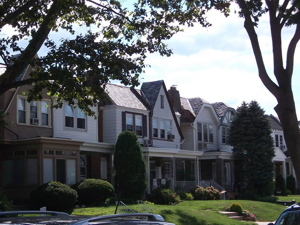
Typical Belmont Village airlites
Bounded by Belmont Avenue, City Line Avenue, and the Bala Country Club golf course, Belmont Heights is one of the City Line's smallest neighborhoods. Across from Bala-Cynwyd and close to Center City, this neighborhood has always been within easy walking or transit distance of the region's major shopping and jobs centers.
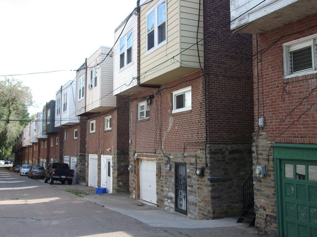
Airlite rears. Notice alleyway and ground-floor garages
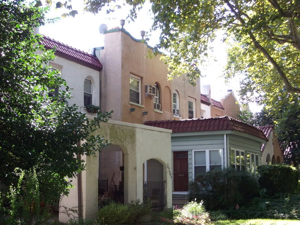
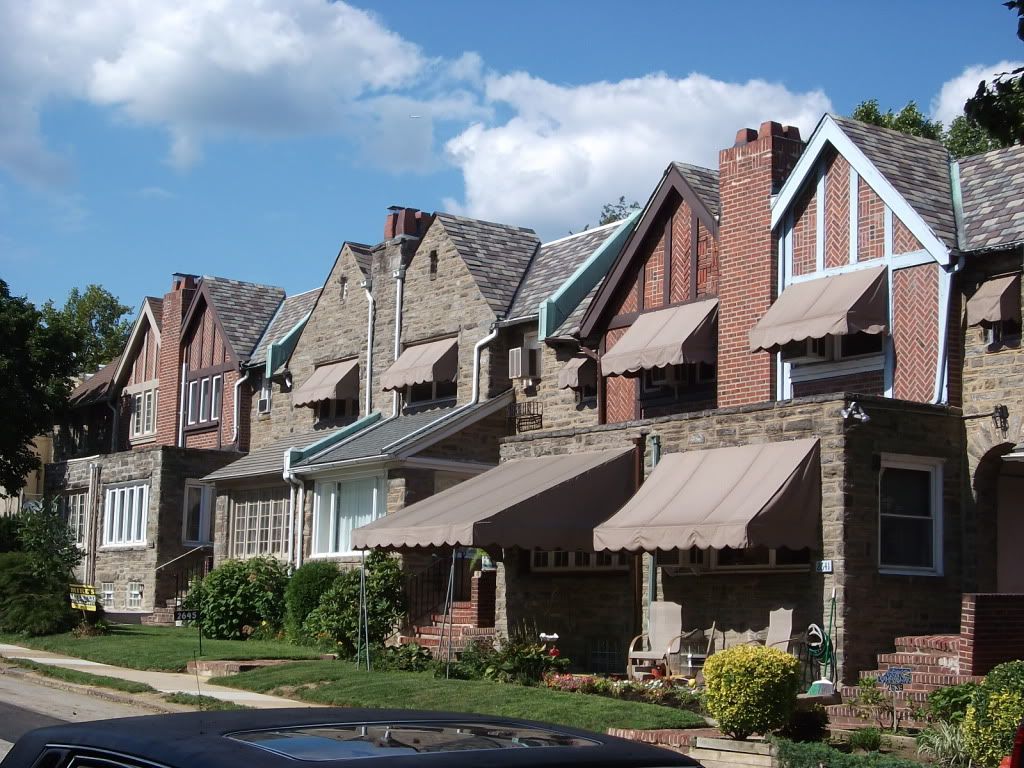
Built almost all in one go in the 1920s, Belmont Village's primary housing stock is the ubiquitous (for that time) airlite, primarily Tudor, although more Deco and Modernist looks creep in amongst newer airlites. Along Conshohocken Avenue, the Mission style, however, holds sway.
Mission-style airlites along Conshohocken Avenue
Larger apartment complexes abut interior Belmont Village's airlites along Belmont and City Line Avenues; shopping lies across the street and at the corner of Monument, Ford, and Conshohocken in nearby Wynnefield Heights. As with all City Line neighborhoods, however, the retail corridor is autocentric; redevelopment into something more pedestrian-friendly would go far in shoring this area up.
A more Colonial style of airlite
Historically, Belmont Heights is more an urban Main Line neighborhood than a suburban Philadelphia (County) neighborhood. The airlite pattern of development, like garden apartments, rose in the 1920s as a way to accommodate that new necessity, the automobile, and bring "light and air" into urban environments via the use of a deeply set-back front yard (which replaced rowhomes' rear yards) and garage-fronted alleys. It is a style that is being adapted in modern suburbia...poorly. This early attempt to accommodate the auto without having it take over a fundamentally pedestrian environment is light-years better than what we see today. As is the building quality.
An alleyway integrates into the local environment. Automotive, but not autocentric, space
Like Wynnefield, Belmont Village is today a mainly African-American middle-class enclave. Like all the City Line neighborhoods, however, there is a growing influx of young professionals moving in and maintaining stability, even as African-American populations continue to suburbanize.

Friday, August 5, 2011

Thoughts on Old Urbanism

The first thought I have on Old Urbanism is about street width. Old Urbanists--particularly Nathan Lewis and Charlie Gardner--argue that our streets should be narrower. A lot narrower.

I have no quarrel with this, in principle. There really can't be much of an argument that postwar streets are excessively wide. When I learned in Land Use Planning 101 that the 1960 Philadelphia Subdivision Code mandated streets of at least fifty feet wide, I was shocked; in the lived environment of urban Philadelphia, 50 feet (three traffic lanes and two sidewalks) is the widest a street feels comfortable at.With the exception of the grand boulevards or proto-grand-boulevards (for example, Broad, Market, JFK, Washington, Spring Garden, Girard, Delaware, the Ben Franklin Parkway), no street in Philadelphia's urban core is ever historically* more than 50 feet wide, and the traditional driving of alleyways through the middle of blocks results in a network of ever-narrower streets and mews. Even so, since Philadelphia's primary grid is built up of 50-foot-wide streets (arterial streets, to the Old Urbanists), the mix here is closer to 49-49-2, in terms of narrow streets, arterial streets, and grand boulevards. This hasn't impinged Philadelphia's urbanism a bit.

Secondly, traffic density can also be a determinant of walkability or human-centrism. The primary Chestnut and Walnut Street shopping core is aligned along a pair of 50-foot-wide streets with two ten-foot sidewalks, two traffic lanes, and a parking lane**, but pedestrians and automobiles are segregated due to no more than the sheer force of traffic. Midcentury planners attempted to pedestrianize such streets--Chestnut was pedestrianized for a while--to disastrous results.

That said, I think that no more than the barest handful of streets need be more than 50 (or at the very outside, a very dense 60, like Ridge Avenue here) feet in width. Beyond this, they split rather than knit. Different neighborhoods also require different street widths to feel comfortable. Neighborhoods built on the picturesque-suburban model*** (such as Wynnefield) feel most comfortable with 50-foot roads; more urban neighborhoods are more comfortable with roads that run between 15-20 ft. and 50 ft., with each city having its own idiosyncratic alchemy of the two: this subtle alchemy helps creates a sense of macro-place: we are here and nowhere else.

The second thought I have--since streets are so wide and setbacks so deep--is that we can narrow our streets, and cities with excessively wide streets can make a pile of money by literally selling off excessive street width, in addition to other densification strategies--granny flats along the alley, carving excessively-deep front yards into new buildable parcels, and flat-out per-parcel redevelopment. In places like Detroit, where, for example, the widest streets can reach 200 ft., you can get whole new blocks.****

There are other ways to ameliorate excessively wide streets. Transforming their centers into various types of green space (hedges, swales, and even alamedas) is a good way to make them less excessively autocentric; an alameda is--additionally--a good way to provide bike facilities in underutilized street space. In a handful of instances, going farther is also an option: a trolleyway down the center of this greened space in the center of the street, maybe?
____________
* Some streets have been widened since. Some the numbered streets accessing the postwar office core of Market West have been widened to 60 or as much as 80(!) feet.
** I do dispute on-street parking a bit...although not by much. The occasional on-street parked car helps control speeding and defines the carriageway, for autos, and effectively becomes a piece of street furniture presenting a lived feeling in the neighborhood for pedestrians: good examples are this narrow (30 ft., I think) street in Manayunk and this street in Wynnefield.
*** Picturesque suburbia is heavenly. Post-picturesque-suburbia becomes ever more hellish.
**** This is not to say that Detroit has a market that can take this additional density, however.

Monday, June 27, 2011

Triangle City

In the comments to my post on grids, Charlie over at Old Urbanist suggested that I create a physical representation of my ideal city from scratch.
Protip: Click on it to make it bigger.
Well, here it is. Carved out of the South Jersey backwoods, Triangle City is the hypothetical conversion of a bunch of farms into a small city of about 30,000. It is done via several design techniques:

1. Street hierarchy. ...Wait? Yep, street hierarchy. Yes, that bane of the suburbs makes an appearance here. The reason is that it's not the hierarchy that makes suburban streets so darn wide, it's the prescribed width of the streets. Here, the hierarchy is:
(a) Intercity highways. Complete streets about 75 feet wide. These are the roads which connect Triangle City to other towns and cities.
(b) Through-roads. Complete streets, or bike-sharrowed streets, about 30 feet wide. These are the arteries of the city.
(c) Local streets. Naked streets, 15 to 20 feet wide.These are the streets that actually go past most addresses.
Unlike autocentric suburban hierarchies, however, this one assumes connectivity. The reason why residential streets stay quiet is because they're so narrow hardly anyone'd think to use them. Pedestrian connectivity, however, is quite strong, since these roads normally interconnect between various parcels.

2. Reserved park and civic space. Three major reserved spaces show on the plan. The central one is Center Park (duh), a large reserved centerpiece civic park, of the type most communities this size lack. The funky-shaped one southeast of it is Civic Square, reserved for governmental buildings (think City Hall). Finally, the long linear park along the northern edge is the nature preserve, Forest Park. Within each neighborhood in this city, however, at least one (1) public park about a block in size and one (1) public playground, same size, is required in the development plan.

3. Reserved space for prime properties. Prior to releasing the land for development, the City will also reserve chief parcels (wonky corners, hilltops, etc.) for prime civic buildings--schools and libraries--and a plot, pursuant to a prior location plan, for combined police and fire stations. Three civic health centers would also be placed.

4. Gridlike Grid. As I noted in my previous post on the topic, the best way to design a grid is to modify it. By using laneways and a few other tricks, the otherwise-strong grid of the city is modified enough to create place and interest.

5. Urban Density. The average density would be about that shown in this post, where wealthier neighborhoods would use this model as single-family detached and less wealthy ones twins or four- to six-unit apartments. This is a density similar to suburbia most everywhere else in the world (Europe, Japan, South America), and is an ideal density for a place that exists at the fringe of the Northeastern megalopolis.

6. Connectivity. (Not shown). A light rail line would connect to the nearest transportation hub, Vineland.
Triangle City lot density
These are traditional techniques laid over a substrate of Pennsylvania pragmatism. The primary failure of Victorian grid was the lack of provisioning adequate public green space; this issue is retained even in sprawl. It is an issue some people just don't get. By utilizing an overarching plan for prime structures and amenities, and enforcing provisioning of secondary ones in land-use covenants, this issue would hopefully be curtailed.

Saturday, June 11, 2011

Garages and Backyards

Expanding on a comment I made on this Old Urbanist post, I have provided a site design for four blocks offering a reasonable house for the money, a spacious backyard, and a small carport with storage area at the rear.
It's how they did it in the 1920s and earlier...with a few tweaks. The houses are 45x45' American Foursquares with five-foot-deep front porches (making them deeper makes them shadier at the expense of backyard space) set on a 50x100' lot. They have been placed asymmetrically, in order to provide side access on one side. A tiny amount of green space on the other side of the lot detaches the structures, since detached structures still have a price premium.

The alleyway is 10 feet wide, and the streets 30. This 30 feet is here translated into two 8' auto lanes (either both for travel or one for travel and one for parking) and two 7' sidewalks. You can go up to 50' in this design and use three 10' auto lanes (travel and parking) and two 10' sidewalks, or you could go narrower still and utilize naked streets.

This site design is easily adaptable, too. By switching out what we think of as proper "streets" with Radburn-style greenways, with the frontage side facing a 9' footpath with 7' access sidewalks, the rest of the former street space is converted into some small front (or side) yards. Thus, depending on frontage type and street width, this type of neighborhood can be optimized for (a) New Urbanism in a lower-density transect, (b) Landscape Urbanism (the Garden City), (c) streetcar suburbia, or even (d) autocentric suburbia. And since it's a '20s-type product, the results are already a pleasant known.
Notice how small the amount of auto facilities is needed for adequate service--just 250 square feet of alleyway and 400 square feet of carport.
But narrow streets are a key feature of the design. A 50-foot street width is barely tenable for a neighborhood street, and if the primary artery has a parking lane on each side, 60 feet would be the maximum allowable. Notice, too, how the way the houses are sited divides the site into a hierarchy of rooms: the street "room", the indoors "room", and the backyard "room". If the houses were sited any further back, the backyard would cease to be spacious and thus an amenity.

Finally, some population statistics. Each block (500x210') has 20 single-family detached houses. With the average family size of 4.3 (2 adults and 2.3 kids), this means the average block population is 46; since each block is (roughly) two acres, this gives a per-acre population of 32, which thence gives a per-mile population of 20,480 with 4,050 square feet a house*...in much of the U.S., an urban population with a large house size, and a population density more than enough to support transit.

How was this done? By narrowing streets and removing ornamental lawns. In a Radburn-like situation, where streets are only needed for vehicular access, even the ornamental lawns are restored while the mean density remains extremely urban.

So bad zoning and bad subdivision regulation is the problem. To put it bluntly: setbacks destroy backyards just as overly wide streets and overly restrictive single-use zoning** destroys place.
_________
* 45 x 45 = 2,025 x 2 = 4,050. This includes neither basement nor attic. Foursquare assumes four 20 x 20 rooms per floor, linked together by 5-foot-wide hallways and closet areas. Eight 20 x 20 rooms is quite spacious for most families.

Secondly, consider if this setup were twins instead. Per-family living area decreases to 2,025 sf plus half a cellar and half an attic (gross 2,025 sf), but the per-block, per-acre, and hence per-mile population densities would all double, now to 40,960 per square mile. Storage shed space would need to double, thus reducing one twin's backyard space, but this would be by a mere 100 sf.
** Notice not Euclidean zoning. A lot of people confuse the two, but when done correctly, Euclidean zoning is extremely flexible and can even include some form-based elements. It can, in other words, be inclusive. By contrast, ORSUZ is inherently exclusive, and when combined with a subdivision code which mandates hierarchical street patterns and excessive street width, functions like place-destroying dynamite. It is a pity traffic engineers know so little about cities since they have unwittingly designed or redesigned so many of them over the past half-century.