Monday, January 27, 2014

Regional Rail from Providence, East

Providence Union Station--back in the day
Alon Levy has kindly pointed out to me that none of the bypasses of the Providence curve really make sense for the stated purpose in the last post; time savings are minimal relative to expense for all of them. (That said, I maintain that the New Haven freight bypass alignment would be an all-around superior route had Union Station trackwork not been removed and erased in the 1970s. It is true, however, that there were excellent urban planning reasons to do something with the existing alignment--it's just that rail access was not considered a a high planning priority.)
New Haven in eastern MA and RI
Even so, the East Side Tunnel continues to have regional use. It is by far the best access alignment from Providence to cities to the southeast--Newport, Bristol, Fall River, and New Bedford. Indeed, it was historically used to provide commuter service from Providence to those latter two cities.
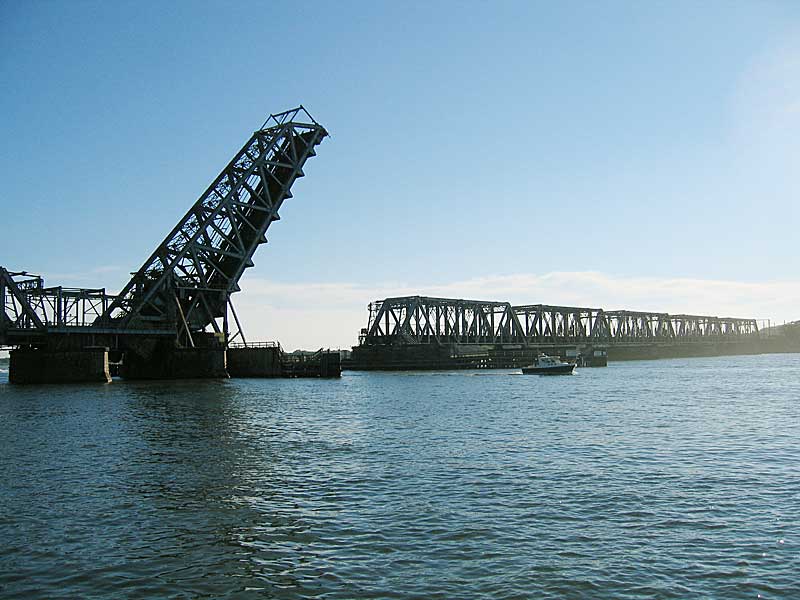
Slade's Ferry Bridge--a lost asset
While the closure and demolition of the Slade's Ferry Bridge severed the link between Providence and Fall River and thence Newport, it does not appear that the New Haven ever actually linked the route from Fall River to New Bedford with its line from Myricks to Newport. Figure 1 shows commuter rail to southeastern Rhode Island using only former New Haven lines.
Fig. 1. Historical NH alignments from Providence SE.
A Circular Argument

Follow the alignments, however, and you'll notice a pattern. Two major alignments historically linked Providence and Newport; they diverged at Fall River. One route linked to the Bristol branch at Warren; the other route ran up to Taunton and around via Attleboro back to Providence. Both are highly inferior alignments today. The implication is that any workable commuter rail from Providence southeast, which hits the four natural termini, must of necessity deal with the region's challenging topography--specifically its strewn-about fjordlike bays.
Mount Hope Bay
Of particular interest is the Mount Hope Bay, whose head is the Taunton River estuary up by Fall River, and mouth flows into the Narragansett Bay just south of Bristol, at the conveniently-named Bristol Point. New Haven easements are available all around Mount Hope Bay, but none provide a good crossing of Mount Hope Bay.
Fig. 2. Hypothetical single crossing of Mt. Hope Bay, superimposed on existing or available rail easements in the area. Reasons against further pursuit--long high bridge requiring access lines to New Bedford (right), Newport (bottom), and Fall River, as well as an excessive greenfield alignment cf. a two-crossing approach--are self-evident. Nearly every other potential single crossing of the bay yields the same, inferior, results.
The bay also demands two crossings. While a single crossing through its middle would theoretically be superior, such a crossing would (a) happen at its widest extent, requiring more than double the superstructure required by crossings at its head and mouth, (b) demand construction of lengthy new alignments to the crossing, and (c) induce excessive branching, needing no less than four different lines to reach each terminus. By contrast, the two-crossing approach allows for two lines--Bristol and Newport would be served by the same line, and Fall River and New Bedford the other.

Across the Taunton

Let us first turn our attention to the Fall River-New Bedford line (FRNB for short). This route is the unification of three discrete routes:
  1. The Somerset Branch, a trace alignment the New Haven abandoned at least prior to 1948. This alignment is salvageable from the junction with the Bristol Branch east to the Lee River crossing, just beyond which the Brayton Point power plant has obliterated the ROW*. This route used to extend across Slade's Ferry Bridge into Fall River.
  2. A Taunton River crossing.
  3. The Watuppa Branch, a good-quality easement from the former mills at the head of the Quequechan to New Bedford.
As good easements are available both east and west of the crossing, most of the time needs to be focused on the crossing itself. As it stands, there are two possible crossing routes:
  • The I-195 alignment across the Braga Bridge and under Falls River
  • The Slade's Ferry alignment with a new alignment built up the Quequechan's remnants to the Watuppa Branch.
These are shown in Figure 3, below. Note that the I-195 alignment, in green, is a good mile less than the Slade's Ferry alignment--thereby optimizing the former.
Fig. 3. Links across the Taunton. In red: the Slade's Ferry alignment that "more-or-less" shadows what's left of the NH alignment; in green, a more direct alignment up the I-195 corridor. Notice how green is dramatically shorter.
Over Bristol Point

The other connection needing to be made is the on the Bristol-Newport line (BN for short, heh). This line has been assembled together for the following three reasons:
  1. Remember what we said about a single-bridge alignment and excessive branching?
  2. A Taunton crossing following the I-195 alignment will by necessity make a cutoff down to the old NH alignment extremely difficult, and furthermore, impinge on potential station sites. No, it is better here to have the station to Boston riverside, and the one to Providence downtown.
  3. As previously stated, a Providence-Fall River-Newport alignment is relatively circuitous. If we want to optimize for straightness (and stay of out Massachusetts), we want a Providence-Bristol-Newport alignment.
Such a line demands a crossing of the Mount Hope Bay by Bristol Point.

On the Aquidneck Island (Newport) side of the bay, this is easy. The NH alignment closely parallels the shore, and the geography allows for a gentle turn onto a bay crossing. Any ramp up can be built alongside the existing alignment.

Far harder is the Bristol Peninsula. The former NH alignment there ran water level as well, but ended in downtown Bristol. Extending from it would require carving out a new waterfront easement, as well as raising track level to the clearance required across Mount Hope Bay.

Far better is a power alignment heading straight down the center of the peninsula. This alignment only extends as far south as Gooding Avenue, however. Extending it further requires cutting through a smallish park and following metes-and-bounds boundaries to minimize takings; it is possible to continue the alignment without significant disruption until between State and Franklin Streets.

At State, entering into a section of town becomes unavoidable; even with an alignment designed to run behind street lots, properties will have to be taken at the cross streets. At Mount Hope Avenue, the optimal easement course curves across Dewolf Avenue through a couple of largish empty lots to run behind Antony Avenue. This, among other things, brings it across the buildup border at Woodlawn Avenue in the woods south of Wolf Cemetery. The proposed route then curves along Metacom Avenue and Ferry Road, alongside Roger Williams University, as it prepares to cross Mount Hope Bay.

Finally, a note: Accessing the power line easement from the Somerset branch in Warren will almost certainly require construction over a fairly large cemetery.

The new Bristol train station would be sited at Franklin Street, where some light industry would be redeveloped into TOD. Indeed, this whole route parallels an extended section of light industry on the east side of Bristol. This may be of use in developing lineside customers.
Mount Hope Bridge
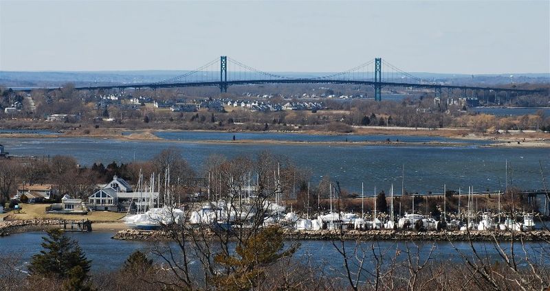
Crossing the bay itself could be done with either (a) a new crossing, or (b) a retrofit of the Mount Hope bridge. For (b) to happen, minor takings of curvature in Bristol Ferry would have to occur, but far more significant would be essentially rebuilding the entire span to significantly heavier loads (not freight-heavy, though) and to have two decks. The current bridge's approach viaducts are rather...spindly...as it is.

Actually, due to the relative age of the current bridge (while the structure is pretty, several obvious deficiencies make it a poster child for functional obsolescence), a multimodal reconstruction may well be called for. Figure 4 below shows how a new alignment through Bristol would work with the existing ones.
Fig. 4. Mount Hope Bay crossing and a new alignment through Bristol, up to Warren.
Into Providence

Two potential alignments could be made into central Providence from the East Side Railroad Tunnel. The first is Option D, as I described the other day as
...link[ing] Providence Station with the old East Side line. Unlike Option C, it does so far closer to the city, linking a short bore tunnel under the Moshassuck and part of College Hill with the existing East Side Railroad Tunnel and running across the Crook Point Bridge.
and the second is Alon Levy's countersuggestion that
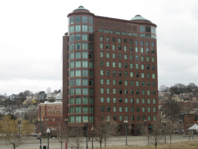
for Providence-centric regional rail, it would be interesting to demolish either One Citizens Plaza or the buildings at the northeast corner of Steeple and Canal and go elevated over either Memorial or Kennedy Plaza).
One Citizens Plaza
(I would note that we may not necessarily need to demolish One Citizens Plaza so much as reorient it to Moshassuck Place; the small plaza between the building and the street appears to be sufficient to hold a two-track elevated facility. It's pretty much built over the old NH alignment as it is.)

While either way works, I am of the opinion that the short (~4400 feet or 1.4 km) cutoff tunnel to the existing station works better in a larger picture. S-Bahn networks, in particular, like to cluster at the core. That said, since Alon's alignment is a reflection of the NH one, and the railroad also had an alignment up the Seekonk--one still in use today--a network built around a new station over Memorial Drive at Union Station is very much practicable as well. Figure 5 shows how the bored (red) and elevated (black) alignments interact with the existing one (blue).
Fig. 5. Tunneled (red) and elevated (black) approaches to DT Providence from the East Side Tunnel (blue).
The Whole Picture 

Having found the existing easements out of Providence southeast, and analyzed the infrastructural challenges required in turning them into a line (or two), we now have the beginnings of a high-quality statewide network centered in Providence. These southeastern routes are infrastructurally the most challenging; we'll look at other routes later. For now, our final result is Figure 6.
Fig. 6. Regional rail from Providence southeast
___________________
*Note that, with Brayton Point's planned 2017 shutdown, opportunity may be had to re-establish the ROW. This would greatly ease curvature from the Somerset Branch onto the I-195 alignment.

Friday, January 24, 2014

Providence Alignments

Of all the cities served by the Northeast Corridor (NEC), Providence has the most severe alignment problem.
Providence Station: Inadequate for the purpose
Providence's current alignment is relatively new. It was installed in the 1980s, to reach a new train station replacing one being decommissioned. It is also, in every way, objectively inferior to the alignment it replaced. There are two major deficiencies associated with this alignment: (1) excessively sharp curvature in the station approach, and (2) undersized station facilities. Figure 1 shows the current alignment (in red) and the old New Haven (NH) alignment, where divergent from the modern one (in purple).
Figure 1: NEC and NH legacy alignment
Figure 2 shows the difference in curvature between the modern and historical alignments.
Figure 2: NEC and NH alignments in DT Providence
From these figures we can ascertain characteristics of the two alignments. The original NH alignment bypassed Providence city--still in use--to reach its main train station, along Exchange Terrace. There, it crossed the Woonasquatucket and Moshassuck Rivers just above their confluence into the Providence River, and diverged. One route headed north to Pawtucket, where it split into routes to Woonsocket and Attleboro. The other crossed Main and Canal streets, and ran through the East Side railroad tunnel, across the Crook Point bridge, and through Rumford and North Seekonk, returning to the NH mainline south of Attleboro. This latter route was built as a freight bypass, but it also proved an important commuter connection from Providence to Bristol and Fall River. The NEC, meanwhile, follows the old NH (originally: Boston & Providence) mainline north to Pawtucket and then east to Attleboro.
Providence Union Station: Adequately sized, unusable
Providence Station, meanwhile, was built to replace Union Station in the mid-1980s. While it improves on the curvature characteristics viz. the old NH mainline, it appears that planners never considered the superior track geometry the old freight bypass offers. Furthermore, the station was built to handle rail traffic at its nadir, and as traffic is increasing, the station is reaching capacity. Indeed, were Providence to have a fully built-out commuter rail network--one possibility is shown as Figure 3--the station would be utterly incapable of handling the demand load. Worse, its predecessor--although still in place--has seen irreparable damage against any possible return of the railroad. The ROW is unusable between I-95 and Canal Street.
Figure 3. Providence commuter rail possibility.
So we now turn our attention to what it would take to actually introduce heavy infrastructure so as to solve these stated problems. Looking to implement low-curvature routes, three options present themselves--each would have its own station facilities. None are cheap.
The waiting room is a bit...small...for a major NEC station
To see the maps I generated for this post, see linked here and here.

The Options
Figure 4. Option A: Providence-state line tunnel
Figure 4 shows Option A. This option parallels the existing NEC, but eases curvature through the construction of a cut-and-cover tunnel under US 1 to Pawtucket, and along Cottage Ave. thence to the state line. Almost incidentally, it eases the moderate curvature around Pawtucket. The diagram shows some curvature around the Blackstone crossing, as it's assumed to follow existing easements wherever available; a deep bore nullifies that.

However, this is a lengthy tunnel--the distance from downtown Providence to the state line is about the same as the length of the Philadelphia tunnel proposal I demolished at length some time ago. And while Providence's infrastructural need is greater than Philadelphia's, one look at the old NH freight bypass suggests it's not that much greater.
Figure 5. Option B: Providence River tunnel
Figure 5 shows Option B. This was the first option that drew my eye on the map--the idea is to eliminate the station curve entirely, something none of the other options do. Unlike Option A, the tunnel is of moderate length.

But also unlike any other option, this one suffers from multiple shortfalls. First, it's the only option with extensive sub-water-table tunneling. The alignment is quite literally waterside. Unlike any other alignment, an entirely new intercity station site must be built--and the best place looks to be quite literally under the confluence of the Woonasquatucket and Moshassuck rivers into the Providence. Part of this alignment lies under semi-active port facilities. And finally, this alignment has a sharp curve that just will not go away. It offers no time savings over the existing Providence bypass.
Figure 6. Option C: New East Side tunnel
Figure 6 shows Option C. This alignment would run a new deep-bore tunnel under the East Side and link up with the old NH freight bypass--with excellent track geometry--in East Providence. Its curvature, while constant, is also gentle, and it has far less length, and hence cost, associated with it than Option A.

It is still, however, a deep bore tunnel.
Figure 7. Option D: "Option-C-cheap"
Figure 7 shows Option D, or perhaps "Option-C-cheap". Like Option C, it links Providence Station with the old East Side line. Unlike Option C, it does so far closer to the city, linking a short bore tunnel under the Moshassuck and part of College Hill with the existing East Side Railroad Tunnel and running across the Crook Point Bridge.

However, in some ways this proposal reeks of a penny-wise, pound-foolish attitude. Not only does it itself have the sharpest curve of all the proposals, despite its brevity, it also fails to ameliorate the lone sharp curve on the NH alignment--at Crook Point. It is perhaps better suited to regional rail than true HSR.
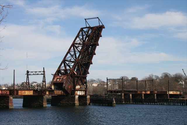
Crook Point bascule bridge, abandoned 1976
Finally, please note Figure 8 below, with all four options superimposed on the legacy alignments, to give one a sense of how each of these stack up against each other.
Figure 8. All four proposals to the same scale.
Ranking the Options

Ranking is somewhat subjective, but my primary criteria, in order of importance, are
  • Cost
  • Length
  • Curvature
As all of these proposals involve a new platform level (at the very least), we can assume that cost is fixed. What we are therefore looking at is thus cost per unit length of tunnel. Of these, Option A is (probably) the least expensive, and Option B (definitely) the most expensive. But looking at the criteria, we find
  • Option A. Cost: -. Length: -. Curvature: +
  • Option B. Cost: -. Length: +. Curvature: -
  • Option C. Cost: +. Length: +. Curvature: +
  • Option D. Cost: +. Length: +. Curvature: -
Option C clearly wins out--but it is not quite the most incrementalist approach available.  
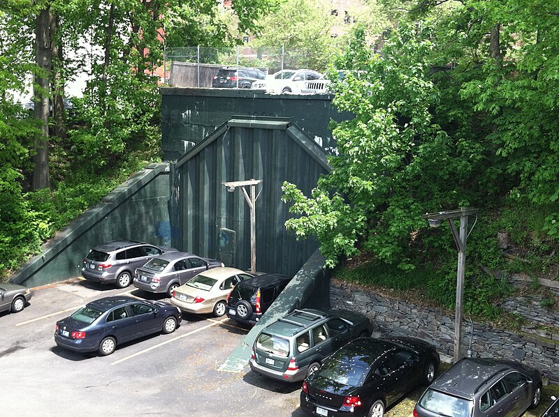
East Side Railroad Tunnel--West Portal
That would be to start with Option D, implementing Option C as and when further funds become available--perhaps as part of a package dedicated to fixing Along the Shore's significant curvature issues in Connecticut. In the meantime, Option D offers expanded station facilities, a better Amtrak alignment, and a platform to develop better--and perhaps, eventually, comprehensive--Rhode Island rail service.
New Haven operations in MA and RI
A look at the core of Figure 3's schematic--Figure 9--displays this, with the East Side line and Option D linked up to create an S-Bahn-esque core.
Figure 9. Figure 3's core network
Conclusion

Ultimately, while Providence's future is its own, what the New Haven left behind was a framework of easements that can provide it with excellent commuter rail. And what the Northeast Corridor needs today is HSR geometry. Hopefully we can do the right, the incremental thing--reactivating the substantial underutilized/disused infrastructure, while judiciously inserting HSR infrastructure where needed. This needs Organisation vor Elektronik vor Beton to happen, though--not the Beton-first mindset our transit agencies always seem to have.

Thursday, January 23, 2014

An Along the Shore HSR Program

Yesterday, Alon Levy offered a critique of the Regional Plan Association's Metro-North critique. As this post is framed in the context of his Northeast Corridor--and especially his Connecticut--recommendations, it aims to do two things: clarify visually his ideas, and offer my own.

The Along the Shore Line
Figure 1. The NEC from New York to Providence, with incremental improvements
The "Along the Shore" Line is the name I have heard given to the New Haven's (NH) principal mainline through Connecticut, running, well, along the shore. In Figure 1, above, Along the Shore is the thin red line; the blue blisters are various HSR bypasses of curvature or clearance issues; and the placemarks are important standalone features. See the map here.
Figure 2. Shell Interlocking. Flat junction; reverse curvature
Working from west to east, the first major feature is Shell Interlocking, where the Hell Gate line--the NH's connection to the former Pennsylvania Railroad--meets the NH mainline, which connects to the former New York Central Railroad in nearby Mount Vernon. Shell (Fig. 2) is a flat junction in a reverse curve; to ensure good performance, track straightening is needed, as is a flyover or duckunder for conflicting moves.
Figure 3. Port Chester bypass alignment. Cos Cob is dot upper right
North of Shell is the first major bypass of NH curves, at Port Chester. This bypass begins just east of Rye Station (new interlocking RYE) and follows I-95 as a bypass of three major curves and a moderate one through Port Chester and Greenwich before returning to the mainline just west of Cos Cob station (new interlocking COB) (Fig. 3).
Figure 4. Cos Cob Bridge
The Cos Cob bridge over the Mianus River is the next placemark (Fig. 4). This bridge is an aging bascule bridge; as HSR cannot afford delays due to lift bridges, this needs to be replaced, and raised to allow marina traffic to clear the span.

Figure 5. Noroton bypass
East of Stamford is the second major bypass, at Noroton (Fig. 5). This begins just east of Stamford yard (at new interlocking NOROTON) and bypasses the flat junction Glenbrook Interlocking and curvature associated with it (Fig. 6, below).
Figure 6. Glenbrook Interlocking
This bypass terminates just east of Darien (at new interlocking DARIEN), where it connects to the mainline and also to Norwalk bypass (sub.). This is because Noroton bypass is meant to be used not just by nonstops, but also by limited-stops that stop at Norwalk and Stamford, but none of the intervening stops, thereby relegating the flat junction to locals.
Figure 7. Norwalk bypass
From Darien Interlocking, the Norwalk bypass extends along I-95 through Norwalk (Fig. 7). This bypass eases some sharp curvature just west of town.
Figure 8. Walk Bridge
But more importantly, it bypasses Walk (Fig. 8) and Saga (Fig. 9) bridges across the Norwalk and Saugatuck rivers, respectively.
Figure 9. Saga Bridge
That it does the latter is a quirk of geometry--but it also means that neither bridge will carry HSR.
Figure 10. Bridgeport bypass
Bridgeport has a pair of severe curves on either side of its station. I-95 also has a moderate curve here; mitigating this will require a new easement (Fig. 10) from just prior of the south curve (new interlocking BRIDGE*) to just west of Stratford station (new interlocking PORT).
Figure 11. Peck Bridge
Incidentally, this will require a fixed-link bypass of Peck bridge across the Pequonnock river (Fig. 11).
Figure 12. Devon Bridge
Northeast of here is Devon bridge across the Housatonic (Fig. 12). This bridge, like the Cos Cob bridge, needs replacing and raising, in order to be a fixed link.
Figure 13. Ferry Street junction
While New Haven is all-stops, and this observation is relatively minor, it is worth noting that the junction under Ferry Street (Fig. 13) is, unsurprisingly, flat.
Figure 14. East Haven easement issue
A new easement is needed just east of New Haven, due to two other reasons: (a) the curve from New Haven to East Haven needs bypassing, and (b) the I-95 alignment does not offer a viable substitution. Fig. 14 shows a the tangent such an easement would roughly need to follow.
Figure 15. Long bypass
The Long Bypass is the longest of the major bypasses (Fig. 15). Its length is due to two facts: (a) the Along the Shore east of Old Saybrook is marked by a combination of lift bridges and sharp curvature, and (b) the replacement alignment, I-95, follows a markedly inland course. An issue of note is the "hump" above the Niantic river, where 95 converges with 395. A virgin easement may be required across the Niantic's top--fingers crossed, I hope not.
Figure 16. Connecticut River Bridge
Figure 17. Niantic River Bridge
Figure 18. Mystic River Bridge
Three of these bridges (Figs. 16, 17, and 18) cross the Connecticut, Niantic, and Mystic rivers, respectively.
Of particular interest is the fourth crossing (Fig. 19) of the Thames River.
Figure 19. Thames crossing alignments
Figure 20. Thames Bridge
This is because of two reasons: (a) the Long Bypass and Along the Shore at at their closest here, and (b) the old bridge (Fig. 20) can be replaced with a high-span fixed link that accommodates both expresses (utilizing the Long Bypass) and regionals (utilizing Along the Shore). Space is available for bridge spirals, thereby reducing the amount of times the old bridge--now utilized by freight--needs to be opened.
Figure 21. Rhode Island easement concern?
A final note (Fig. 21) pertains to a couple of moderate curves in rural Rhode Island, north of Charlestown. While replacement is not necessarily a priority, takings are inexpensive here, and a straighter easement (such as along my tangent line) could be developed.

Past this point, the line has excellent track geometry--the Acela hits its full speed here--north to Providence. Providence has some curvature issues of its own, but we'll talk more about those later.
___________________
*Which would also replace current Port Interlocking in functionality, incidentally.

Tuesday, January 21, 2014

On Retail

Saw this at Zero Hedge.

Keep in mind the deep structural fragilities of the average four-anchor regional mall. There's the fragility resulting from the slow decline of the middle class, and this is what blogs like Zero Hedge focus on.

Then there's also a management fragility, a fragility that stems from the very design of the mall: To be healthy, it is dependent on the health of all four anchors. Mall dead zones are intensely correlated with closed (or "dead") anchors. Since the beginning of the '90s, there were basically five different entities that would anchor a mall:
  • Sears
  • J.C. Penney
  • Federated (Macy's)
  • May (Strawbridge's, Hecht's, Filene's, Kaufmann's, Marshall Field, etc.)
  • Regional chains (Boscov's, Dillard's, Belk, Northern {Bon-Ton, Carson Pirie Scott, etc.})
Sector consolidation has been in full force since the '70s, when Macy's was semi-national and most regional malls had two regional chain options, with the loss of chains as large as Wanamaker's, Gimbels, Stern's, Hudson's, the Emporium, and Woodward & Lothrop, and as small as Hess Brothers, Lit Brothers, Bamberger's, Abraham & Straus, and countless other minor metro and secondary major metro chains.

The problem is that the four-anchor model matured just before this contraction: When malls such as Montgomery Mall, Neshaminy Mall, Oxford Valley Mall, Christiana Mall etc. were designed, REITs (mall developers) usually had a buffet of six or more potential anchors to court. A four-anchor mall was a nice tradeoff between mall developers and the anchors themselves, none of which would need to be in every mall to achieve market saturation. Failures such as Dixie Square in this environment were rare and more linked to demographic misprediction.

But the so-far culmination of the contraction in the 2005-6 Federated-May merger resulted in further anchor erosion, such that four-anchor malls could court only four anchors:
  • Sears
  • J.C. Penney
  • Macy's
  • Regionals
And since Federated (Macy's) and May duplicated each other in many, many malls, these malls were left with just three anchors. The growth of Target as a mall anchor has helped somewhat, but Target is independent in a sense that the older anchors just aren't. It isn't a coincidence that the inventory of dead malls began growing more quickly after 2006, as many malls with a merger-lost anchor saw themselves go obsolete, and lose more and more stores.

Either the collapse of Sears or J.C. Penney would catalyze the exponential growth of dead malls, a point Zero Hedge makes, largely because it would collapse the available anchor list for most malls from four to three (and keep in mind that hypermarkets e.g. Target generally make poor anchor candidates, as they're usually co-located in the same strip, just down the road), thereby creating large dead sections in most malls--and exacerbating dead sections of malls that still have dead sections left over from 2006. In fact, for the latter case, such a collapse spells a death knell, as, once a mall drops below a certain occupancy threshold, it generates inadequate rents to be self-sustaining.

A further issue is that more profitable malls currently cross-subsidize less profitable ones. This is why malls that obviously take massive hits on facilities maintenance, such as many of those featured on Dead Malls, can afford to stay open until Claire's, Gamestop, and Radio Shack are the only tenants left. Just the collapse of Sears or J.C. Penney harms the mall model overall, because the cross-subsidizer loses one of its major income centers (the wing it anchored), in turn reducing the internal cash flow to the subsidized dying/dead mall, forcing more dead malls to close etc.

Just the collapse of Sears or J.C. Penney makes the mall financially fragile.

The collapse of both wipes out whole wings, or halves, or--for malls still dealing with a 2006 anchor loss--more, of leased leasable space in 99% of all malls. Even the most financially robust malls see their balance sheets shrink to breakeven. Already dying malls are discharged. And for the typical challenged, already breakeven anchor mall, there is no white knight, no cross-subsidizer left. Only a truly slim subclass of malls--those with carriage trade anchors*--could possibly emerge from this for the better.

The net result would be a ripple contraction throughout the retail sector, as REITs merge to survive; inline stores contract locations and staff as they clear out of dying malls; and who-knows-what other consequences fall out of the vicious cycle.

Why does this matter? Aren't malls obsolete anyway?

To answer the second question first: Yes and no. Yes, the regional mall is an obsolete business model, but no, it's not online retail or lifestyle centers driving them out of business. For the former, I like to say that  Amazon is to us what the Sears catalog was to people living in the 1900s: that is, remarkably convenient, but not convenient enough to trump the bricks-and-mortar shopping experience. The numbers bear this out (Zero Hedge ibid.). And for the latter, lifestyle centers are just newer shinier malls, very occasionally with a prototype infrastructure of resiliency in them.

The thing that is really killing the mall is the return to relevancy of the very thing it displaced.

For the former question, this matters because--nearly all job growth in the last decade (or more) in any sector that doesn't require mastery of calculus has been in retail sales. And in most suburban markets, the highest job densities in this sector, after revitalizing Main Streets, are--in regional shopping malls. Just as the traditional setup cross-fertilized sales, so too did it jobs. Lifestyle centers replicate this to some extent, and hypermarket-driven power centers don't hold a candle. Of course, nearly all non-Main Street retail offers little more than servitor jobs, but even so...

The implication is clear. Concomitant collapse of Sears and J.C. Penney brings the mall to its knees. In doing so, it catalyzes the downsizing of almost every inline chain, as they scramble to locate or relocate to the remaining profitable malls. And in doing so, it catalyzes a major percentage cut in the retail jobs numbers. This, in turn, negatively affects mall patronization**, further weakening the remaining malls, further catalyzing consolidation, causing yet more cuts etc. in a vicious cycle. And of course, since retail jobs have been the only positive fudge for economists, a sector collapse would lead to significant wider economic implications.

The large-scale arc appears to be: The return of the (antifragile) entrepreneur, the Main Street retailer, and the failure of the (fragile) nationalized franchised chains. Bricks-and-mortar is resetting. But the path there will be ugly.
_____________
* I.e. Barney's, Bloomingdales, Lord & Taylor, Neiman Marcus, Nordstrom, Saks Fifth Avenue, and a handful of regionals or one-offs such as Von Maur.
** Among other things, such as further stressing a stressed welfare state.

Sunday, January 5, 2014

Decline and Fall

I am continuing to think about Tverberg, the strengths and weaknesses of her work. Today, I want to focus on what I think is her greatest weakness--her doomerist belief, not well backed by the evidence, that a collapse of civilization means a collapse back to a hunter-gatherer lifestyle, or worse, hominid extinction.

Why is this a problem? First off, it ignores the archaeological evidence regarding the collapse of civilizations. The vast majority of all human civilizations have collapsed, and only a tiny minority of these collapses have ever resulted in pre-agricultural regression. A tinier--to the point of statistical insignificance--minority resulted in local extinction. In fact, in the known record of hundreds and hundreds of civilizations, only two resulted in self-caused* extinction--Easter Island and Viking Greenland. Indeed, of all known literate civilizations, just two--Harappa and Minos/Mycene--clearly succumbed to pre-literate regression**, and there is no known example whatsoever of either a literate civilization with an alphabet, abugida, abjad, or syllabary regressing to a pre-literate state***, or a literate civilization regressing to a pre-agricultural state.

To me, these statistics suggest that there is a negative feedback cycle in place that arrests further decline after a civilization's fall. Recall that a feedback cycle is two of four things: either positive--that is, amplifying--or negative--that is, canceling--and either virtuous--working properly--or vicious--out-of-control. Hence this hypothesis does not imply "negative" connotations, but rather simply states that the positive (amplifying) feedback cycle associated with the decline and fall of civilizations is arrested, braked by a negative (canceling) cycle at a certain point.

It is likely that this latter cycle is linked to easily-transmitted information--consider that all alphabets, abugidas, abjads, and syllabaries are orders of magnitude easier to master than ideographic systems, regardless of phonetic (mis)match; or that e.g. basic agricultural information is easy to understand and disseminate--and it also implies that the bare handful of instances of total regression, either to extinction (as in Easter Island and Greenland) or to pre-literacy (as in Harappa and the Minoan Aegean) were caused not only by the decline and fall cycle, but also by the failure of its stabilizing countercycle to kick in.

The easiest to understand in this regard is Easter Island. Its inhabitants stripped the land bare of its already-meager resources, and its total isolation prevented meaningful contact with neighboring civilizations of any kind. That is, they removed the necessary conditions for their own survival. The failure of the stabilizing cycle to kick in was almost undoubtedly caused by the lack of catalyst for it to get going in the first place. Similar holds true for Greenland, although here the Vikings chose not to tap the last two resources they had had left by the onset of the Little Ice Age: the island's fjords' wealth of fish, and their contact with the "skraeling" Inuit.

So a resource meagerness comes into play here--and it implies that an exceptional resource constraint is a necessary condition for the failure of the stabilizing cycle as well. Normal agrarian resources--a nutritionally complete suite of food crops and the arable land to plant them in, a reasonable fuel source for heating (where necessary) and cookery, raw material for simple tools, and neighbors to trade and war with--are almost ubiquitous on the continental landmasses, which explains why (a) there is but one example of pre-agrarian regression archaeological record (Australian Aborigines), and (b) paradoxically, why gatherer societies have persisted in the most resource-rich regions on Earth^: agrarian societies are solutions to the problem of not being able to gather enough caloric content in one's territory for a burgeoning population; so long as they are able to, agrarian impulses are weak. So long as the fundamental resources for maintaining an agrarian society have remained in place, no society has ever collapsed beyond that baseline.

So what exactly is the arresting mechanism? I do not know, but I do know some catalyst events and some historical stages that imply catalyst events:
  • For medieval Europe, two arresting mechanisms seem to have kicked in. First, the stabilization of social order under the feudal hierarchy. Second, the retranslation of the Hellenic library from Arabic into Latin (yes, all knowledge of Greek was lost, despite the proximity of a major Greek-speaking state), which halted its intellectual free-fall.
  • For the Greek dark age, the principal catalyst seems to have been the refashioning of the Phoenician abjad into the world's first true alphabet; it is probable that their city-states also emerged around the same time. This dark age also appears to be part of a broader cultural discontinuity associated with the end of the Bronze Age and the beginning of the Iron Age throughout the Levant.
  • The creation and codification of Vedic liturgy, as well as the expansion of the culture associated with it, appears to have marked the end of the post-Harappan dark age.
  • The rise of the Hohokam, Navajo, and Pueblo cultures appears to mark an end to the post-Anasazi dark age.
  • The Andean Late Intermediate period effectively represents a dark age from the fall of the Tiwanaku and Wari cultures (states?) and the rise of the Inca state, Tawantinsuyu.
The normal course of a dark age appears to be marked first by the fall of the preceding civilization(s) until a nadir is reached--this is when the stabilization feedback fully cancels out the decline and fall feedback--after which the positive feedbacks associated with civilization-building reengage, until finally a "new" civilization emerges in its own right. Renaissance periods mark the clearest demarcation of this final stage, though not the only one; the civilization continues from there to maturity, at which point a negative feedback loop cancels the civilization-building cycle and triggers the decline and fall one.

Perhaps these are intertwined cycles. That is, the stabilizing cycle that arrests decline and fall and the civilization-building cycle are one and the same thing, just looked at from different points of view; so too the decline and fall cycle begins life as the negative feedback cycle that arrests the civilization-building one. Feedbacks linked in such a manner are not a new phenomenon: ecologies and economies are chock-full of them. And in the end, as itself a complex adaptive system, isn't it meet that civilization should as well?

Let us end with the two key takeaways. First, cultural knowledge of agriculture, once gained, is not easily lost--at least, as long as the conditions for supporting an agrarian lifestyle--and there are not many--are met. And second, that^^ the knowledge of a mass writing system has not once been lost, on a cultural level, in any decline and fall. I suspect that, in the event of collapse, we would never fall beyond the level of post-Roman Europe; even more likely is that we never fall below the level of the early Renaissance (mass literacy being a new benchmark in the history of civilizations). Even in general collapse, stabilizing and growth forces are still at work.
___________________
* Obviously, local extinctions caused by unpredictable natural events (e.g. volcanic eruptions) are not counted. This is because what we are looking at is the decline, not just the fall. Extinctions caused by catastrophic natural events represent an interruption in the course of civilization.

** 1. While Minoan Crete and Mycenean Greece are clearly separate civilizations, they were also deeply interrelated, and had, for the purposes of this discussion, essentially the same writing system (Linear A and Linear B). We could also call the Minoan/Mycenae complex the "Minoan Aegean".

2. One would then suggest that the loss of knowledge of the Maya and Egyptian hieroglyphs is evidence of pre-literate regression. This is not the case. Egyptian hieroglyphs were supplanted, first by demotic scripts and then by Coptic; knowledge of their decipherment was lost until translation materials (the Rosetta Stone) and linguistic reconstruction techniques became available in the early 19th century. Mayan hieroglyphs were one iteration of a broader ideographic writing tradition throughout Mesoamerica--the Aztecs were in the process of developing one for Nahuatl when Cortés landed--and the Spaniards had, and destroyed, an extensive Maya library.

*** Indeed, the Amharic abugida is still in use, despite the fact that Ethiopia is clearly in a dark age relative to its late-medieval period status. Nor did the Roman alphabet ever fall out of use after the fall of its formative culture, despite the fact that very nearly every other trapping of civilization was lost in Western Europe in the period 500-1000 CE.

^ Australian Aborigines stand out as the biggest exception. But Aborigine societies had the benefit of neither contact with neighboring agrarian societies, nor suitable arable land, nor local potential domesticables that could provide for a nutritionally complete diet^*.

^* Incidentally, the presence of the dingo does indicate that the proto-Aborigines did undergo pre-agrarian regression (dogs were among the first thing domesticated, and dingoes are very feral dogs); but as has been outlined above, much of Australia--due, probably, to the continent's extreme geological age--lacks many of the basic resources agrarian societies need. Is it really all that fair to expect an agrarian society to persist when, in the fortuitous circumstance that one actually has land fit for growing things in, one doesn't have anything to grow in it?

^^ This is less of a sure thing, considering the fact that all civilizations that have used either (a) an alphabet, (b) an abjad, (c) an abugida, or (d) a syllabary are only a very minor subset of all civilizations; they are, however, a much larger subset of known civilizations.

Thursday, January 2, 2014

Complexification

One of my favorite blogs for thinkers is Gail Tverberg's Our Finite World--she is perhaps among the most perceptive people on the blogosphere for recognizing that peak oil's effects are economic, not geographic, and that they have far-ranging realizations, due to the nature of economies as complex adaptive systems.

Even so, her prediction that, if things continue as they're going, we will soon hit a state of collapse worries me. Part of it is something that the Germans call vorsicht--a sort of Malthusian prediction that one should be aware of, wary of, and work to avoid--and part of it is that her claim that the nature of economies--complex adaptive systems--is the problem, is bad metaphysics. Causation is, after all, an action--it is what Thing A does that causes Thing B; the nature of Thing A has no bearing on Thing B (although that nature makes certain suites of actions more appealing and others less appealing).

Think here on Jane Jacobs' The Economy of Cities. A trite summary of the work is that a city is a complexification machine. But, as she pointed out, certain elements within the machinery of a city work to make it more efficient--that is, less complex--and when this becomes the dominant factor in a city's economy, the city stagnates, then fails. The classic examples are Detroit and Manchester--actually, most examples have faded altogether from history, and are remembered only by the name applied to the product their economies centered around.

Something similar seems to have happened to the global economy. Complexification has broken down; seeds of decline marked city after city after city by the 1950s; work creation* has stalled and wages have remained (inflation-adjusted) stagnant since the 1970s. Jacobs herself called attention to this in Cities and the Wealth of Nations, published just when these trends were becoming apparent (c. 1980). The root problem that we face then isn't that the economy is a complex adaptive system--indeed, if it weren't, it wouldn't be the ecology of human enterprise--but rather that, in our efforts to understand and manipulate it, we have introduced an excessive amount of efficiency--the tendency towards simplification, don't forget--into the works. In other words, we are stripping the gears of their lube. Again, Jacobs realized this; her last title was the ominously-named Dark Age Ahead.

One of the reasons I like Tverberg is that she thinks along similar lines as Jacobs; often she realizes or brushes against one of the latter's points (though I doubt she's read her), but I suspect her misdiagnosis of the root problem is rooted in thinking about systems as things in themselves, rather than considering their elements...But then, this issue is partly due to the general failures of macroeconomics.
_______________
* Not to be confused with "jobs creation", which is nothing more than a political talking point. What I'm talking about is the creation of new types of work. In a complexification machine operating full-bore, new types of work are being constantly phased in, and old ones phased out (for various reasons). What happens is that the new types of work are so much in excess of the loss of old types of work that the city becomes a magnet for the ambitious; this differential increases through iterations. By definition, stalling work creation doesn't mean that new types of work aren't being created; rather, it means that the difference between new types of work being phased in, and old types phased out, is close to zero, or worse, negative. Economies where this is the case are not healthy economies. (Of course, quantification of this is difficult, which is why it hasn't been pursued in lieu of easier monetized measurements.)

Wednesday, December 18, 2013

The Forgiving Design Hierarchy

While this post started as a fork from Compromises on North Broad, it is really a topic unto itself, and a core post of my thinking on how design affects safety. I am calling it (in draft) the forgiving design hierarchy concept of street design workflow. I hope that, as you read, the reasons will become clear.

Hierarchy

The key is attaining a tradeoff--a balance of priorities. To do this we need some sort of hierarchical modal evaluation criteria. This could be easily abused and turned into a checklist by the same kinds of numbnuts who eviscerated any pretense of urbanism in Syracuse, but having such a checklist exist, and be public knowledge, would be an invaluable tool in project evaluation and project criticism. For a street--a value-creation platform--modal consideration would progress
  • Pedestrians
  • Cyclists
  • Dedicated Mass Transit (if applicable)
  • Motorized Transport
in that order. This is tied to an underlying principle that design consideration scales with modal vulnerability--that is, the more vulnerable a given user is, the greater the design consideration for them should be. This, of course, does not preclude high-quality facilities for the dominant (and in road situations, usually the only) mode of travel; rather, it merely states that first attention should be given to a facility's most vulnerable users. This does not really affect the layout of true roads at all; indeed, it subtly enforces the road/street division in transport hierarchy.

The Role of Forgiving Design
What we call "forgiving design" is the set of auto-oriented transportation engineering design guidelines that first emerged with the initial construction of the Interstates. It is an extension of rural design standards, applied with the idea that such standards would improve speed and flow in urban areas. That it is should surprise no one: as I have just pointed out, even in my revised system, most rural byways would stand unaltered. Unfortunately, urban areas, busier and more congested (both good and bad), are hence more incident-prone. The problem is, of course, that current forgiving design principles have proven to be a failure at increasing safety in urban areas--and, even worse, have proven to be a disaster from a safety standpoint in suburban areas (cf. Dumbaugh and Li).

Subjective Safety

Key to the performance of the Dutch cycling network is a concept called subjective safety, the realization that, when it comes to driving usership, the perception of safety is just as important as what is, statistically, "safe". So the optimal approach to generating the prioritization hierarchy above would seem to be to implement subjective safety principles across the more vulnerable modes, fitting forgiving design for automobiles in where it can fit (precisely the opposite of our current approach, which fits in infrastructure where it can fit after the cars are designed in). But--at least in London--subjective safety and forgiving design appear locked in battle, with TfL's flow needs trumping subjective safety needs, despite the lobbying of numerous cycling-advocacy organizations.

Two Sides of the Same Coin

But the principles of subjective safety are the principles of forgiving design--just applied to a different mode. The whole point of subjective safety, the perception of safety, is achieved by creating an environment forgiving of error; the whole point of forgiving design is an environment forgiving of driver error. This intermodal mesh drives the British conflict: on London's limited road space, who gets the space allocation they need for their approach? Who "wins"? Are they the drivers, accommodated by forgiving design, or the cyclists, accommodated by subjective safety? But it doesn't have to be this way: understanding that they are one and the same allows us to integrate the two elements--forgiving design and prioritization hierarchy--into a single model.

Upshot

Subjective safety and forgiving design, now revealed to be one and the same thing, merely tell us how to design safe* infrastructure for a particular mode. But our world is multimodal. To answer the question of which mode gets priority, the hierarchy, increasing attention for increasing vulnerability, yields the answer. Hence the framework which I am proposing, and wish to investigate further, is one where we
  1. Consider a given route. Consider factors such as existing usership(s), current population density, planned population density, distance/mode optimization, origin/destination proximity, etc., to model usership. For roads, none of this matters. But roads also cannot have curb cuts.
  2. Design for each user in turn of vulnerability.
  3. For each mode, apply forgiving design concepts. For places with low pedestrian volume, but increasing bike volume, for example, a multi-use trail will work.
  4. Evaluate whether or not the tax base can support the design. If not, reduce until within this "solvency envelope".
which is, of course, largely alien to current transportation engineering workflows.

Further Questions

This is just a framework. Many unanswered questions within this framework remain, such as what minimum adequate forgiving design for each mode would be, what optimal infrastructure in several contexts would look like, and even the whole question of designing for enduring financial solvency. In fact, this framework is the core of the research I wish to pursue, largely because I find myself convinced this is the right approach and would like to see it applied and further refined--but as it stands, it is hardly ready-to-go as a framework, and is rather much more conceptual.
_________________
* With certain exceptions, e.g. suburban arterials, where forgiving design appears powerless against an even more foundational foe, the curb cut.

Tuesday, December 17, 2013

Compromises on North Broad

Jon Geeting recently picked up on an implicit idea in my Width, and the Perception of Width article: giving Broad Street the same design standard as e.g. Paris' Ave. Kléber. He has also run further with this idea than I ever conceived, including the idea of putting a BRT lane down Broad. While these are all good ideas in their own right, however, at a certain point Broad Street--especially North Broad--will demand, at a certain level, compromise.

The reason for this is a legacy of highway projects that never got built, particularly in the northern suburbs. While this is, as Alon Levy pointed out, good for mass transit (and a major reason why reactivations of the Newtown Branch and Bethlehem Branch (at least as far as Quakertown) are good ideas), it does impose a certain stark reality on Broad Street.
The 309 (blue) and 611 (red) corridors both feed into North Broad.
Both of the major highways serving the northern suburbs--PA-611 and PA-309--drain onto North Broad. Because of this, much of the traffic into Center City from central Bucks and Montgomery Counties comes down North Broad: while the Northeast Corridor May function as an escape valve, it only serves a small portion of the northwest corner of this area; commuters from Ambler, Doylestown, Flowertown, Glenside, Hatboro, Jenkintown, Warminster, or Willow Grove have little choice other than SEPTA or North Broad. And of course, commuters from (especially) Churchville and Richboro have none. This makes North Broad's demand far higher than South Broad's, one of the reasons why the current traffic pattern involves converting a parking lane into a through lane at peak.

This raises the difficulty that, while an MWB would be easy to implement on South Broad, it is somewhat more difficult on North Broad. While it certainly offers significant traffic calming and safety improvements, it doesn't really address flow interruption congestion (congestion caused by traffic lights), which the peak fifth lane functions as a band-aid for; implementing it as a reversible lane would  (a) make it quite difficult to fit everything else onto the street, in addition to being (b) quite ugly. And of course, the real solution to the flow problem--eliminating traffic lights--would be catastrophic for all other users. All of this implies that North Broad requires, at minimum, four through lanes with good light timing minimizing stops, which, of course, dashes any hope of BRT on the corridor. (Not that the 4 or 16, with the subway underneath, really need it.) That said, BRT would be useful on several other corridors, such as Erie, Allegheny, Lehigh, and Washington Aves. BRT could be run down the less busy South Broad corridor, but it is, if anything, even less useful there (cf. Reading Between the Lines).

So the key is attaining a tradeoff--a balance of priorities. To do this we need some sort of hierarchical modal evaluation criteria. This could be easily abused and turned into a checklist by the same kinds of numbnuts who eviscerated any pretense of urbanism in Syracuse, but having such a checklist exist, and be public knowledge, would be an invaluable tool in project evaluation and project criticism. But what would this entail? To see my answer, partitioned from this post due to increasing lengthiness (not that that's stopped me before) and as subject matter deserving its own post--stay tuned.

Saturday, December 14, 2013

Franklin Flea

Franklin Flea
I checked out Franklin Flea this morning, and found out something surprising about Strawbridge's.
The elevator hall
A lot of people--especially people who were never in it before it closed (like me)--assume (like me) that its ground floor was a single large sales hall. This is not--nor was it ever--true.
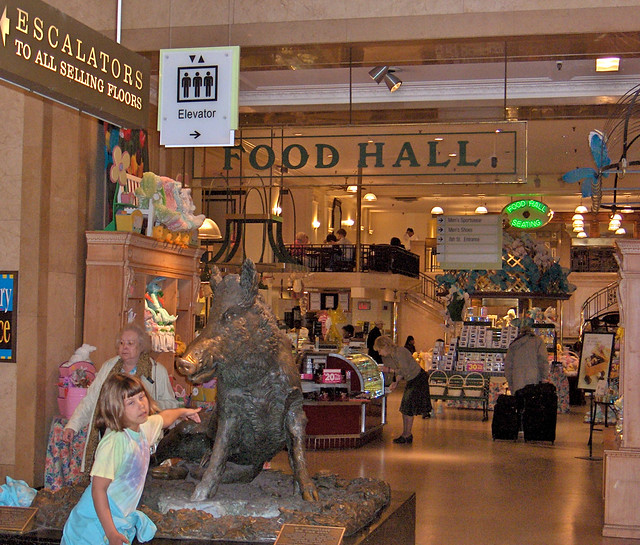
The Food Hall, with purdy fixtures
In reality, Strawbridge's ground floor has several discrete parts: the 1928 structure is bisected on its latitudinal axis by its elevator core; the boar sits where the hallway that serviced this core crosses the one linking the entrance (cosmetics and accessories?) hall with the Food Hall. A secondary hallway runs between the end of the elevator core and the wall between the 1928 structure and the late 1800s-one on the west side. I am unsure, but I think the jewelry department may have run the length of that section's ground floor. (The Department Store Museum directory implies that part of the Men's Store was on the ground floor as well.) Compared to the open, warehouse-like layouts we expect at hypermarkets and yes, even mall department stores, nowadays, Strawbridge's layout is very difficult to work, and insisting that a single entity take over what remains of the ground floor selling space now that two office lobbies have been carved out of it surely ranks as an endeavor in fruitlessness. Indeed, it is hardly meet to insist that the Food Hall--reportedly being considered for an Eataly--be leased to whatever other entity/ies lease(s) the remainder of the ground floor*.
The Food Hall in Strawbridge's' last days
Leasing solutions?

So it appears that the there are three remaining halls and change off the store's central hallway (leading through the elevator lobby). If we assume that Eataly will get the Food Hall, as seems increasingly likely, this means that the rear portion of the 1800s structure, whatever remains of its forward part, and the entrance hall would be in play. The size of the older halls makes them ideal for inline stores, so let us focus on the entrance hall.
Scope of the entrance hall
There are no fewer than three entrances to this hall from Market Street, which implies that it could be split three ways. Two, if hall to Eataly via the boar were to be kept open. Or even four--it's that large. But of course, doing so would undermine, perhaps ruin the ground floor's grandeur. And to make things more difficult, the Food Hall does not have its own street entrance. But only a very large presence could fill up the Main Hall.
Seeking an anchor

Perhaps the trickiest part of this endeavor is engineering ways to ensure that the entrance hall remains internally linked to the basement and second floor. My position is that until and unless we have a clear tenancy plan that would fill both parts, we should not--cannot--sacrifice these internal linkages. This implies that if (when) Eataly fills the Food Hall, we should seek a plan that links the entrance hall and the elevator hall together. But of course such a plan would cut the Food Hall off from its historical main entrance, in front of the boar. And it's entirely possible the Food Hall isn't as large as I think it is.
Another look at the entrance hall, from its SW corner.
But--the final note--with the persistent Gallery Bloomingdale's rumor**--and my own Circuitous and Serpentine post of a year ago--whose original concept now bears updating (though it is still valid)--the Gallery has space for three anchors, and if one of them is Bloomie's, that means that the other two just became that much more valuable. Could we be looking, in the near future, at a Gallery anchored by three of the following--?
  • Barney's New York
  • Bloomingdale's
  • Lord & Taylor
  • Neiman Marcus
  • Nordstrom
  • Saks Fifth Avenue
  • Von Maur
A Gallery able to compete with King of Prussia for high-end inline retailers? Ah well, one can only wish.
___________________________
* BTW if anybody knows whatever happened to the original Food Hall fixtures, could there be any way of bringing them back for Eataly? 'Cause those look pretty darned cool.
** The fact that Bloomie's passed up on the Daffy's space (1700 Chestnut) because it's "too small" does not sound like an outlet concept to me. Outlets, like Saks Off 5th, Last Call Neiman Marcus, and eventual Daffy's lessee Nordstrom Rack are typically ~30k sf.