Tuesday, May 31, 2011

Tea Party Urban Planning? Bad for America!

Found this article on the intertubez (thanks Urban Planning Blog). Here's a choice excerpt:

When planners asked audience members to rank the importance of open space like parks, Gass exploded. “Open space also includes people’s private property,” she said. “You cannot ask people to vote on something that violates others’ private property.”

Lou Hexter, who was leading the exercise, tried to placate her, saying quietly, “It’s good to hear everyone’s opinion, but we need to ——.”

“Back off!” Gass yelled.

To the Tea Party, a lawn counts as open space? I smell something rotten.

Lawns in the United States come about as a result of setback requirements. That is, the zoning code mandates that a structure on a property be set so-and-so feet from the street, from the sides, and from the rear. Philadelphia's R1 zone, for example, requires 65% "open space" on the lot via these setbacks. That is, the lawns are regulated in.

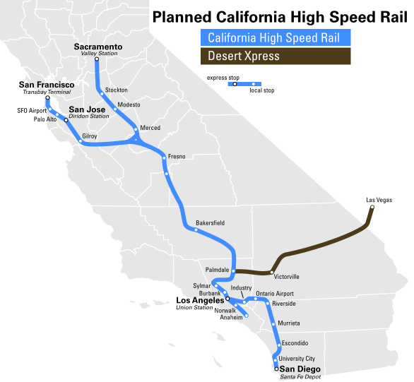
This is manifestly at odds with the Tea Party's self-proclaimed less-regulation ethos. But it is in keeping with Tea Partiers' actions. This "movement" is really a hypocrisy on a grand scale: it uses far-rightist ideology to promulgate the current status quo--at all costs. Scott Walker, despite the truth of rising gas prices, elects to spend money on idiotic and shakily justified road-widening projects while rejecting guaranteed monies for improved rail service--remembering that what passes for rail service in most of the U.S. would be considered barely rudimentary anywhere else in the developed world. Christie axes ARC (a political decision whose legal ramifications will haunt him the rest of his career) in favor of bailing out troubled and ever-incomplete Meadowlands Xanadu, or whatever they're calling it now--a shopping mall whose success in an era when shopping malls are seen as passé is dubious at best. Florida nixes high-speed rail (again). And these ideological vultures are circling Calfornia's incipient system.

Tea Partiers see driving as "freedom" and trains as "socialism". But I have news for them: the Interstates are socialist! They are a public commons in this country, but elsewhere in the world (France) they are privately tolled and operated. They are private. And how much public transportation money do we spend on them? The system is 99.9% complete (there is a section in Mississippi which was never finished) and so any road widenings or new proposals on the Interstates are done for one reason and one reason only: to promote sprawl, as defined by the overly-restrictive, overly-regulated land-use planning of most suburban municipalities. But demand for this sprawl died in 2007 and it ain't coming back.

It is an irony that California Tea Partiers are, instead of de-regulating our built environment, thereby making development more flexible, implicitly assuming our over-regulation status quo as an ultimate good, and continuing this over-regulation, due to their own narrow view of what a home should be. But the market is fighting this regulation--and so the Tea Partiers are fighting the market. Libertarian ethos elevates the market to apotheosis: to libertarians, the market is sacred, and must not be fought. So the Californian Tea Partiers have discarded libertarianism: through their actions, they prove they are not libertarian.

It is unsurprising, however, when one considers the cultural underpinnings of the Tea Party. Narrowness and dogma in thought produce narrowness and dogma in politics and policy. Intellectual justifications, to this anti-intellectual subculture, are just a game of smoke and mirrors. But the Tea Party's influence far exceeds their actual numbers, and in any event, its message is antithetical to Generation Y. It's at its obstinate, obstructionist apogee, and as it becomes forced to define itself by actions and not just words--we see these actions and we don't like what we see.

Which is why the end of this article brings me such a nod of grim relief:
Even with the group of vocal critics, when the audience voted on priorities for the Bay Area, the top five were: daily needs close to home, clean air, convenient access to jobs, water conservation and lower carbon emissions. “Large homes with big yards” was near the bottom.
The words flash onto a black screen: “The ‘New World Order’ is here.” Dramatic music swells as the message continues: “One Global Vision, Designed by the United Nations, To Strip you of Your Freedom.”
What could be so sinister? According to the video posted on the East Bay Tea Party’s website, it’s the Sustainable Communities Strategy being developed by two of the wonkiest governmental bodies in the Bay Area: the Metropolitan Transportation Commission and the Association of Bay Area Governments.

Society Hill-Mt. Airy Line

Along with Pennsport-Andorra, the Society Hill-Mt. Airy Line forms the second half of the Loop backbone. This line is the Germantown Avenue backbone, connecting the sections of this area where transit access currently is relatively poor. Additionally, it stretches east, servicing Society Hill and Penns Landing.

This line would lie between the two major spines of North Philadelphia, the Broad Street Line and the Pennsport-Andorra Line. Its major purposes would be to (a) serve Mount Airy and central Germantown, (b) serve lower and central North Philadelphia, (c) to serve western and southern sections of Center City, and (d) to serve several institutions along the way, primarily the Eastern State Penitentiary and Girard College.

Another feature of this line is its expandability: this line can easily be extended along Front or the Delaware, should demand permit. Combined with the Pennsport-Andorra line's first phase, the first phase of this line, along with the Lindenwold Line, is envisioned as the 2025 system core, the Loop skeleton these lines sprout from.

Monday, May 30, 2011

Basics: Enclosure and How to House People

Enclosure, in urban design terms, is an assessment of bounding. There's a way of talking about it architectural terms, using "forms" and "voids", and in planning terms, using "active areas" and "passive areas", but either way it becomes way too technical way too fast: the language being used is a language of exclusion rather than inclusion, and when we talk about enclosure, we're talking about one of the most inclusive things humanly possible. That's why instead of using words, I'm using a series of three pictures to show the way enclosed space evolved during the half-century from 1900 to 1950.

I'm going to focus on enclosure within a block. There's another form of enclosure, the street, which is generally governed by the same rules, but the issue of frontage (which direction the façade faces) is a good deal more important when considering street enclosure than intra-block enclosure. In any event, the Old Urbanist had a good post which--while it talks about something else--viscerally demonstrates the poor level of street enclosure we endure in North America. Notice how well enclosed European streets are viz. American ones.
Intra-block, enclosure tends to be used as yard or garden space. This rear space nearly always exists; before being required by zoning, it was an amenity used by speculative rowhome developers to sell their product. The diagram shows the minimum level of open space guaranteed by the Philadelphia Zoning Code: rowhome residential (R10 and R10a) zones have requirements of 10% open space, 5% for corner properties (as a nod to the greater access to "light" and "air" available on those properties). Philadelphia rowhomes generally sit on 16'x90' lots and are 20' to 40' high*, and this diagram is a representation of the zoning envelope. Small developers in R10/a today, much as they did even before that zoning description was invented, build to the street line, eliminating any need for a front yard (although some occasionally appear, especially when the neighborhood went through a mail-order house round of development), and park all the usable yard space at the rear. This space was supplemented by the "public yard" function of the neighborhood square**, although it was relatively uncommon in Philadelphia for speculative developers to provide one.
One of the major changes in urban housing was the development of the garden apartment in 1920. While after WWII, the meaning of the garden apartment morphed into something suburb-friendly, 1920s-era garden apartments can be said to be something of an optimum in terms of multi-unit urban housing. Setbacks were minor and usually enhanced the street, while the large interior courts, usually maintained as gardens, provided well-enclosed green space. Garden apartments of the period were normally five stories tall. Because the courts were surrounded by living units, the whole complex had a high degree of "eyes on the street", both inside and out, and just via changing the height, the concept could be scaled from downtown densities all the way down to suburban.
If, however, the market had found an optimal way to house people, both in single-family and multi-family formats, new Modernist architectural and planning theories, primarily Le Corbusier's Radiant City, and the growing predominance of the automobile and rise of autocentric planning and autocentric mindset, worked to extinguish these optimums nearly as soon as they took hold. Development of airlites (rowhomes' lookalike successors) and garden apartments had nearly ceased by the 1960s, save in bastardized versions amenable to autocentric-scale suburban development.*** In the city, the tower-in-a-park model came to attract American planners wielding the blunt-force tools of land clearance and redevelopment, even as European planners were developing a range of finer-grain tools. Perhaps the ultimate tower-in-a-park is I.M. Pei's Society Hill Towers, three towers on the hilltop overlooking the neighborhood and a wide swath of the river wards.

But the great failure of the tower-in-a-park is its lack of enclosure. Enclosure is built by defining space into a series of public or semi-public rooms, whether via streets or courtyards or quadrangles or neighborhood squares. By contrast, the tower-in-a-park model came out of an ethos of flowing parkland, a mindset which pictured habitation as a space within parkland rather than parkland as a space defined by habitation. But parkland is passive by default; without a clear definition of space and usage a park fails. Even large urban parks, such as Central Park, Prospect Park, Fairmount Park, or Golden Gate Park, parks which function as centerpieces, crown jewels in their cities' (or boroughs') park systems, also have other functionality which is, again, defined and contextualized by the city--by the park being the city's great enclosed space, rather than the other way around, the interspersion of city and passive park until the park becomes a barrier passable only by car. Corbusier foresaw this consequence and welcomed it; we today, however, have discovered how burdensome such a setup is, and so we rebel.

This fundamental difference between the way passive space is seen is a dichotomy that today finds new champions on different sides of the debate: New Urbanism, led by Andrés Duany, and Landscape Urbanism, led by Charles Waldheim. While we see this as just an academic dispute, the difference in the ways Duany and Waldheim see the city must give us pause--and we must reflect on both the good of Landscape Urbanism (James Corner Field Operations is behind some of the best, most spectacular public spaces in America today), the bad (Frederick Law Olmsted was behind the rise of the picturesque suburb, the form which every postwar suburb has sought to mimic), and the ugly (Landscape Urbanism is just a new enabler for towers-in-a-park, a development model which, in 99.9% of all cases, failed, but is still routinely envisioned by Corbusier dogmatists unwilling to let their master's bad ideas go).

James Corner is today's Olmsted, and just as good, but he is still a parks designer, not a cities designer. Cities enclose and define the types of spaces people like Corner design, but people like Waldheim would have you believe that parkland is the be-all-end-all of the urban space. It is not: there is more than one type of enclosed space, and when enclosed space loses its enclosure--its definition--it can very well morph into a barrier prohibiting urbanization and densification.
____________
*The height limit in R10/a is 35'; however, even Victorian mansards routinely exceed that height. Developers want the height limit raised to 42', something I agree with.
**When it existed. If one looks through old WPA maps, one will be struck by how few neighborhood squares there were--and still are--in large parts of Philadelphia. Paucity of neighborhood squares was one of the major (valid) criticisms Lewis Mumford leveled at cities, particularly in his Culture of Cities.
***I grew up in an airlite in an airlite-and-garden-apartment community likely built in the 1970s at the edge of the urban area. These housing optimums had, by this time, been bastardized all the way into suburban rental "community" design--an ultimate indignity.

Drop DROP

I'm sleepy now, but here's an excellent summation of the DROP controversy.
Despite months of controversy, Council President Anna C. Verna - who at least bowed to political reality by scrapping her own reelection as she prepares to collect a $585,000 DROP check - put off grappling with the program until after the decisive May primary. During the campaign, unions representing police, firefighters, and other city workers demanded candidates pledge fealty to DROP, as most Council hopefuls did.

Now that the dust has settled, with Democratic nominees confident of reelection, Council could do the responsible thing and scuttle the retirement program. Voters made clear their disgust by spurning reelection bids by two political stalwarts enrolled in DROP: Councilman Frank Rizzo and City Commissioner Marge Tartaglione.

DROP serves no legitimate management purpose. More important, a city facing one budget nightmare after another - with schools being the crisis du jour - simply cannot afford to sweeten the regular pensions due to retiring city employees. Finally, there is no scenario under which incumbent elected officials should be able to take advantage of such a perk. 

Council members who really want to move the city forward need to face up to the fact that it's time for a clean break. Drop DROP.
 Today's Philadelphia City Council: A body of contentedly corrupt politicians who don't even recognize their corruption. No DROP-enrolled politician in any competitive race stands a chance of winning. Just by making some noncompetitive races competitive, we can further get rid of this cancer on our city's finances.

Soon to be written: a discussion of what demographic shifts mean for Council districts and what each district will likely do to maximize incumbent strength.

Friday, May 27, 2011

FRA Is The Problem With American Railroading

I'd just like to permalink to Alon Levy's latest post. He hits the nail right on the head as regards American railroading and the woeful state of regulation this side of the Atlantic. In particular two passages stand out to me:
Under present FRA regulations, not much more than NEC service levels can be done: rolling stock would have to meet guidelines developed for the steam era, curve speeds would be limited, and the signaling would not provide enough capacity for adequate service levels on shared track. This is independent of the incompetence of every FRA-compliant railroad; in fact part of the incompetence is manifested in unwillingness to try to get waivers, even though Caltrain, a small operator, applied for a partial waiver and got it.
 and:
In contrast, no reform of the FRA is possible short of a complete overhaul. The appropriate passenger rail regulation in the US is that everything that’s legal in Japan or Europe is legal in the US, and the only local task should be a skeletal staff reconciling European and Japanese rules where necessary. A piecemeal approach leads to partial and suboptimal reforms, requiring additional testing of already extensively used trains.
Quoted for truth.

Dropsie College

 Here is an interesting find.

There's a small collection of old buildings on North Broad, just north of Temple University, at York Street. When I first saw them I assumed it was a bank on the corner, and the building recessed from the street was some Gilded Age nouveau riche's manse.

Ah! It turns out not. This small complex was actually, at the turn of the century, the location of Congregation Mikveh Israel, and the building set back from the street--the one that looks like a manse--a college founded by the synagogue's Gilded Age leaders. This college, Dropsie College for Hebrew and Cognate Studies, was actually, at one time, one of the premier centers for Jewish and antiquities studies in the United States. People such as Noam Chomsky's father taught there. Founded in 1907, it was, throughout its 79-year history, closely interlinked with Penn, and during the 1980s, after an arson attack, moved out of this handsome North Broad edifice to Lower Merion, and eventually merged with Penn, becoming the Center for Advanced Judaic Studies (CAJS). The Dropsie library is now a key part of Penn's Semitic studies library.

Below is an image of what it looks like today, from Google Street Maps, and here is also what Penn's librarians have to say about it (warning: PDF). Note that according to the 1942 WPA maps on PhilaGeoHistory, Dropsie College's address was 2321 North Broad, and the synagogue, 2359. A small institution, Gratz College, which may or may not have been attached to Dropsie, but was certainly attached to the synagogue, is also marked at 1340 W. York.

Thursday, May 26, 2011

Zoning

Philadelphia's Planning Commission is rewriting its zoning code. It's been a long time coming--the Code was last completely revamped back in 1960, and has accreted so many amendments that it's exceedingly difficult, in some situations, to even determine what exactly the Code says about a parcel--and will largely be either no change or a positive change, in terms of what somebody can do on a parcel. (The new 25% deviation rule, for example, will help cut variance requests, especially on grandfathered buildings, such as mansards, too tall under the 1960 code, by quite a lot.)

But the strangest discussion about the Code, to me, has always been about the densest districts.

Philadelphia's maximally dense zone is C5, which would become RC5 under the new Code, the zone of the core of Center City, among other places. Areas zoned C5 (RC5) look, in the main, like the cap over I-90 in Boston's Back Bay, or Chicago's Loop, or downtown San Francisco, and especially like Midtown Manhattan. (The grid precludes Lower Manhattan.) Average height in Center City's urban core is 20 floors, with some exceptional structures, such as the Comcast Center, BNY Mellon Center, or Liberty Place, marking the skyline from afar.
C5 (RC5)-zoned area

Which is why I find it so odd that C5 (RC5)'s base zoning is for 1200 FAR.

FAR is an acronym for Floor Area Ratio, and describes the maximal height (by stories) on a maximally-covered lot. A FAR of 1 would allow a one-story building to completely cover the lot; 1200 FAR therefore allows for maximal lot coverage of 12 stories. The Wanamaker Building, which is actually 11 stories but completely covers its lot, is usually used as an exemplar of a 1200 FAR structure. Other rules, relating to Philadelphia's height-bonus system, also describe what kinds of uses are included and excluded in FAR description (retail podiums are excluded according to current bonus standards, while public space (outside) and public rooms (inside) both qualify as open space, for example.)

Even with this considerable leeway, however, something is rotten in the state of Denmark, and the 1900 Arch apartment proposal tells us what.

1900 Arch is a proposal for a 19-story apartment building with two ground-floor restaurant pads and underground parking: a proposal that makes intuitive sense. The layout is essentially a latter-day interpretation of a classic garden apartment, with wings along Arch and Cuthbert streets enclosing a pocket park space in the middle, which would be used for (among other purposes) outdoor seating for the two restaurant pads. Some people think it's ugly, but de gustibus non disputandem and à chacun son goût and all that. So far, so good.
1900 Arch

What is mysterious is why this project has to get a variance at all*. The site is a lot in the densest part of Center City, a mere two blocks from the Comcast Center, BNY Mellon Center, 2 Logan Square, and the Bell Atlantic tower, among others; it would be a dense building among other dense buildings. And it--surprise surprise--is being opposed by a group of NIMBYs from a nearby condo, complaining about things such as "air" and "light", which is, let's be honest, just cover for "I don't wanna hear construction noise for a year".

1900 Arch should be regarded as the typical Center City project. Its density is context-reasonable**, it offers ground-floor retail and some green space, and it hides its parking--the bottom line, it behaves well. This is exactly the type of building we should be fostering, by making construction of it and others of its ilk as streamlined as possible. It should not need to get a variance. Why, then, does it have to?

Even at 1200 FAR, Philadelphia's densest zoning is not dense enough to adequately describe Center City's densest areas. While yes, there is a need for variances and bonuses and all that usual horseplay when something that impacts the skyline is proposed, for a project like this, with (among other things) minimal skyline impact, there should not be a need to go through ZBA and the Planning Commission. Rather, C5's maximal FAR should be 2000 (20 stories), which would permit as of right more infill apartment projects of this type, which, in its turn, will eat more of those pesky Center City parking lots*** that just seem to always stick around.

Assuming (R)C1 and 2 stay constant, I would suggest that the (R)C section of the Code be revised as such: RC3, 500 FAR; RC4, 1000 FAR; RC5, 1500 FAR; and RC6, 2000 FAR. This way, once FAR kicks in, increasing structural density is a given. The kind of thinking that gave us a C5 with 1200 FAR is exactly the kind of 1960s thinking we want to be rid of--not promulgate.
_________
* Well, okay, technically the site's zoned C4, the penultimately maximally dense district in the City of Philadelphia, but with a FAR of 500, the dropoff sure is quick. This also serves to demonstrate the antiquity of the zoning map as a whole, since the site hasn't called for a C4 zoning since 1970 or so, certainly not with the Sterling and Kennedy House right next door.
** As opposed to, say, Northern Liberties' American Loft, a maximally-dense type building in a neighborhood characterized by rowhomes and industrial-scale lofts.
*** Such as (in no particular order) 1450 Chestnut, 1301 Market, 800 Market, 900 Chestnut, 951 Sansom, 1300 Arch, 1401 Spring Garden, 800 Race, 2201 Market, 2250 Market, 68 N. 23rd, 3000 JFK, 3001 JFK, 3001 Chestnut, and so on.

California Dreamin'

 Basically, from Fresno most of the way to Bakersfield, on this map

How the TGV start? It started back in the 1970s when the ligne à grande vitesse sud-est (French for "really fast southeast line"), or as normally abbreviated, LGV Sud-Est, was planned and built. This line ran from Paris to Lyon, and eventually would extend to Marseilles.

But it didn't start in the cities. No, the line actually started out in the country. The physical LGV Sud-Est runs between Saint-Florentin, in Yvonne départment, and Sathonay, in Rhône (formerly Ain) départment.
 TGV, in original paint scheme, running on the LGV Sud-Est 

Where?

Precisely.

The point I'm making is this is why California's LAO is dead wrong. Of course hardly anybody knows where Borden and Corcoran are, because hardly anybody needs to know. But then who knows where St. Florentin and Sathonay are? The LGV Sud-Est runs through the countryside, between what were, in 1980, Paris' and Lyon's most far-flung exurbs, and accesses the metropolitan centers via existing infrastructure*.

Likewise, even though Borden and Corcoran are the technical endpoints of the line, they're just interchange junctures. Passenger trains, such as the San Joaquins, would interchange onto the line in lieu of their current via-freight-lines routing at these places; their true origins and destinations would be well beyond Borden and Corcoran. The line is just a piece of infrastructure that operations (trains) utilize. Borden-Corcoran makes sense as a way of speeding up intercity trains' intercity travel, just as the LGV Sud-Est did. What the LAO is doing, in essence, is conflating the HSR-standard line with the equipment it's being built for.

Presumably, once the line extends past Bakersfield (Borden-Corcoran runs through Fresno and Hanford), HSR equipment would begin to be put into use, if not sooner; as the line extends, so too will the fastest trains' access area.
CAHSR Picture. Yay!

_________________
* Gare Montparnasse was rebuilt in 1969. The original station was built in 1840 as Gare de l'ouest (West Station); as a result, the infrastructure (station throat) predates the current patron experience (architecture).

Reading Viaduct, Pt. II

See it right there? It's even been highlighted.

The publicly-accessible embankment along the 1200 block of Noble? The one that's all skuzzy and filled with broken glass? Do something with it. Go ahead, Reading Viaduct Project. Go ahead, Viaduct Greene. There's your pilot. Make that a livable park and then you might see more money for your ultimate mission.

I would love to see the Viaduct turned into a park. But it won't magically appear out of nowhere. The High Line took years of blood, sweat, and tears; years of the incessant dedication of the Friends of the High Line, to happen. The Friends continue to fund a sizable chunk of the park. So, for me to believe the RVP and V. Greene are adult enough, capable enough, to handle a park of this complexity, I'll need to see more than pretty renderings. I'll need to see examples. I'll need to see them actually maintain some small chunk of this Viaduct they want to be entrusted with. There's one available. Go ahead. I'm waiting.
What it looks like on the ground.

Wednesday, May 25, 2011

Extending the Market-Frankford Line

This is another post in the Philadelphia2050 series.

The Market-Frankford Line (locally called the "el") is the busiest heavy-rail route in Philadelphia, with some 180,000 daily riders, a number that compares favorably with anything the CTA, MTA, WMATA, or MBTA could put forward. It is a broad-gauge line using under-rail contact third-rail electrification, a setup totally unique in the United States, and its dynamic envelope is somewhat narrower than the Broad Street Line's. The line doesn't have any express tracks, and in fact, its daily operation pattern is near-optimized given its constraints. Its current trains are 8 cars, the same length as the line's shortest station, 5th Street; lengthening this station might allow longer trains, certainly necessary given the line's frequent crush loads.

The line currently terminates at Frankford Transportation Center in the near Northeast; while the capacity constraints laid out above prevent it from being used as a Northeast subway, a relatively short extension may be used to help the capacity problem.

This extension would involve a connection with the proposed Roosevelt Boulevard subway at Bustleton Avenue. Since the Boulevard subway would connect into the Broad Street tunnel, which does have express tracks, and a surprisingly high proportion of el riders go from Center City to the Northeast, with a transfer at Frankford, this expansion would be integrated into the Phase I construction of the Boulevard line in order to hopefully cut the el's ridership some--as I mentioned, congestion is an issue at peak hours, when train cars are beyond SRO and simply packed to gills.

The second part of this extension is an extension to place. The corner of Cottman and Roosevelt is one of the major retail centers of the Northeast, and the el extension there simplifies access to place. With improved access, of course, densification of the heart of the corridor--the stretch of Cottman from the Boulevard through Bustleton to Castor, would be encouraged. Also of interest: the proximity of this stretch of Cottman to Pennypack Park suggests a possible sub-use as a bicycling trailhead.

The three new stops (Roosevelt Bvld., Tyson, and Roosevelt Mall) would be expected to generate some new traffic, but this is counteracted by the siphoning effect of the major junction at the Boulevard and Bustleton. A study earlier this decade suggested that a Boulevard subway would have as many as 300,000 daily riders; this extension, being limited in scope, would have far less.

Pennsport-Andorra Line

The Pennsport-Andorra Line is one of the three new lines in Philadelphia2050's Loop network. It is the backbone which connects between Andorra, Roxborough, Manayunk, East Falls, Strawberry Mansion, Brewerytown, Fairmount, Spring Garden, Callowhill, Chinatown, Wash West, Bella Vista, East Passyunk, and Pennsport; it directly serves the Italian Market, Rodin Museum, Community College, and Art Museum; it offers a development spine along Fairmount Park's eastern edge; and it's generally an all-around good guy.

This line forms the northern and eastern spine of the Loop, and interconnects with the existing Lindenwold Line and Ridge Spur, as well as the proposed Tasker Park and Society Hill-Mt. Airy Lines; it is built to the same dynamic envelope (of course) as its existing interconnections, and is planned to eventually be able run ten-car trains. Its Phase 1 is also the easiest to implement.

This ease of implementation comes from the fact that it utilizes existing easements and rights-of-way wherever possible. Phase 1 replaces the Spur, for the time being, with a train that follows the current Spur line from 8th and Market to Ridge and Noble, and then follows a subway under Noble Avenue to about Broad, where it emerges into the City Branch Cut. It then follows the Cut through to its connection with the Pennsylvania Avenue tunnel, which has one in-use track in a space built for six; it runs along this tunnel's eastern half and into the cut north to Girard Avenue. The only new tunnel to construct on this line is, in fact, along Noble between Ridge and Broad--only about half a mile. Current Spur trains would be transferred to this line, eliminating the need for new equipment; the only remaining expenses are the installation of the trackwork, the third rail, and stations. Phase 1 would run two-car trains, Phase 2 five-car trains, and Phase 3 the full ten-car sets eventually envisioned.

The extreme lack of expense relative to the solution it offers: connection of Center City's northern sector into the heavy rail network, and the expandability of the plan, suggests merit for immediate implementation. More than almost any other Philadelphia2050 proposal, this one would solve a lot of problems right away.

Tuesday, May 24, 2011

Planning the Park West Area

Fixing wasted potential west of Fairmount Park

The Park West area is special in my heart because it's where I live. It consists of three Philadelphia neighborhoods--Wynnefield, Wynnefield Heights, and Belmont Village--west of Fairmount Park and east of the Main Line (you can see it passing Overbrook Station), as well as Bala and Cynwyd* villages in Montgomery County. It's home to St. Joseph's University, the Philadelphia College of Osteopathic Medicine, two more seminaries, and about 30,000 jobs clustered between City Line and St. Alsaph's east of Belmont Avenue. It even boasts a minor skyline accentuated by its hilltop locale.

But it's a weird place. The job core in Cynwyd is like Corbusier's wet dream, towers surrounded by an expanse of parking. Apartment and condo developments attempt to be towers-in-a-park while at the same time turning a blind eye to the beautiful expanse of upper Fairmount Park. So ignored, in fact, is it that what should be prime land that airlites, not towers, border the park!

Other than that, City Line from Belmont to St. Joe's is a fairly typical example of a suburban strip. Philly's Saks and a Lord and Taylor, oddly enough, reside here. St. Joe's has two residence halls (Rashford and Borgia) hugging the street--a first--but neither goes the next step and develops ground-floor retail. The fact the base is used for parking is hopeful, however; the available floorplates are large and easily enclosed, should desire merit. Finally, City Line is home to a number of 1920s-era garden apartments; these are the district's oldest buildings and are a handsome building stock.
The plan is split into three sections for convenience: the section including Wynnefield Heights and the Cynwyd office core is the picture above, and the one for the stretch of Parkside behind the Mann Center below.
The pictures are simple enough, but a word about the transportation plan: the 10 extension, 49, and 100 proposals from Philadelphia2050 are all worked in, as is (parenthetically) the Cemetery Heights line. The 10 extension is a fairly straightforward lengthening of the existing line about five blocks up 63rd from the current loop just south of Woodbine up to the Overbrook train station, low in expense and moderate in impact; the 100 (fuller post later) would be a route stretching from 69th Street Terminal up to Ivy Ridge via City Line and Main Street Manayunk; it would run predominantly on a dedicated ROW in the middle of City Line. City Line itself would be made a complete street according to best practices. In Wynnefield Heights, the 38 and 40 have been reworked slightly, and the 39 extended from its current terminus across the Strawberry Mansion Bridge, allowing for a more direct route from this jobs center to Temple U. and the nicer parts of Kensington. These routes now all service nearly all Wynnefield Heights' main byways. In the longer term, with parkside densification, a light rail extension, perhaps a conversion of the 40 into light rail and a rerouting of the bus lines, will make sense. As it is, there are too many towers-in-a-park there now, and not enough towers-by-the-park to make this section of the city seem a destination.

Two other major transportation features in this plan are (1) adding pedestrian interlinkages in the superblock between Presidential, Monument, Neill, and Conshohocken, as well as a pedestrian path along the park edge (Parkside Avenue is extended for lot access), and (2) the extension of the Cynwyd Trail from Cynwyd Station down to Bryn Mawr Avenue. This will connect the Belmont Plateau into the region bike network, and offer a new bike route between Center City and the Main Line, as well as a velocentric interconnection between Center City and Cynwyd. Eventually, this route will cross the Pencoyd Viaduct and connect with the Schuylkill Valley Trail near Shawmont.
Finally, this plan establishes a TOD area around Overbrook. Despite its regional importance, the place where City Line crosses the Main Line is underbuilt. The Executive Apartments turn a parking garage to the street; the corner of City Line and 63rd across from the station is a grassy lawn between two garden apartments. St. Charles Borromeo Seminary has a massive grassy field fronting City Line less than 500 feet from the station, and the Merion Gardens too snubs the main artery. Overbrook is where the Thorndale Line, 10, and 100 meet; it is the south anchor of City Line; densification here is most important.

So there you have it, and you also have my philosophy towards urban planning: zoning and design guidelines (face the street, numbskulls!) are my arbiters--I do not urban plan at the site level. Transportation planning, however, is one of the most importation parts of urban planning, and thus (outside of upzoning and preservation areas), most of my urban planning is actually access (transportation) planning.
_________
* Pronounce: Kin-wood.

Monday, May 23, 2011

Without a City Hall station makeover, the remake of Dilworth Plaza is a waste

Paul Levy, head of the Center City District, has done more to improve Center City in the past twenty-odd years than almost anyone else. His current project is a revitalization of Dilworth Plaza, originally built in the 1960s, Vincent Kling's multitier monument to his architecture (at one point, nearly every building flanking the plaza--City Hall excepted--was a Kling), a cold granite fortress on the former sites of the Arcade Building and Broad Street Station's headhouse.

It's a good project. But it must also depend on SEPTA's participation, since this project is being done (or is supposed to be done) hand-in-hand with a total revitalization and renovation of SEPTA's dilapidated busiest subway station, the City Hall/15th Street complex. The logistics of this renovation are challenging, in no small part due to the station's being interwoven clean around City Hall's foundations--giant pylons running the middle of the Broad Street Line's two platforms--and the incredible density of infrastructure and pedestrian passageways underground.

SEPTA, once again cash-strapped, has recently announced its plan to push back the renovation, one of the most important projects in the current system, undersized as it may be. If this plan is pushed back, though, and Dilworth Plaza goes forward, that would be a major travesty.

For when City Hall station does get revitalized, the renovation would, by necessity, need to tear up large parts of the plaza--parts which would have just been put down.

What we are seeing in action is a breakdown in communication between two entities which have been working together for years now on this plan. If the breakdown reaches its final stage, and Dilworth Plaza goes forward before the station reno, it will result in double the work on the plaza--and double the expense.

So, Paul Levy, please put Dilworth Plaza on hold until SEPTA can get the funding for its part!

Sunday, May 22, 2011

The Reading Viaduct


At top: the Reading Viaduct, and at bottom, highlighted,
the City Branch Cut

From time to time, the Reading Viaduct Project makes the blogosphere rounds. It's a beautiful-sounding idea: turn an abandoned old embankment-and-trestle system, the former station lead for the Reading Terminal, into a park-in-the-sky à la James Corner's High Line. New kids on the block Viaduct Greene even suggest extending this park into the attached City Branch Cut.

For the most part, I like this idea. Both of the Viaduct sites are on my blogroll, after all. Callowhill has a lack of usable parkland, and the trestle section, while obsolete for railroad purposes, is still usable for other forms of transportation--bike networks, say. While Viaduct Greene's sunken section is definitely overkill, in large part because Philadelphia2050 (which, remember, this blog is dedicated to) suggests that the northern side of the Center City loop should be routed through it, the historic nature of this cut as the former right-of-way of Noble Street suggests that its continued use as a transportation artery--a bikeway connecting with the Viaduct--is still a viable idea.

But there are all sorts of other givens and druthers (as the Viaduct Greene folks are keen on saying). Callowhill is still largely un-redeveloped and still feels "unsafe". There is little money for new park investment, and funding priorities should be pumped into the underfunded existing system first, especially when the site is Superfund; and finally, the Chinatown CDC is dead set on bulldozing at least a part of it (something I'm against).

All I'm saying is that it's a good idea, but I would want to see funds raised privately first, and to see a CDC or two support it. It would still take at least a decade to happen, but Callowhill needs a decade to further grow.

EDIT 5/24: Landbank it!

Skirting Light Rail around Center City

Light rail is one of the most difficult aspects of Philadelphia2050 to figure out. In my initial conception of the network, I had crammed both of planned new West Philadelphia light rail lines, the 37 from Eastwick via Lindbergh Boulevard, and the 49 from St. Joseph's University and Wynnefield via the West Park, into the existing Subway-Surface tunnel running from the corner of 40th, Woodland, and Baltimore to Juniper and Market with an additional exit at 35th and Ranstead. Since light rail is essentially a bus on rails, capacity for this tunnel is about as high as you'd expect. Even with five lines (10, 11, 13, 34, 36) accessing this tunnel, there is definitely still space for more.
But then I read this post on Human Transit, and a light bulb went on: why am I cramming everything into the tunnel? Just because I can? I had noticed some SEPTA routes which originate in Overbrook and Wynnefield running to South Philly--the 40 originates at the corner of Monument, Conshohocken, and Ford and terminates at Headhouse Square and the G originates at Lankenau Hospital and terminates at Columbus and Oregon, for example--and I wondered if there might not be some efficiency involved. Then I thought about my heavy rail network (to be explained in a later post) and how both my Ridge-8th and 19th-Society Hill lines are essentially two lines which inter-run via the Center City Loop and I realized that the 40 and G aren't one line so much as they are two lines which have been merged.
Using this, I could justify running my new routes onto Girard and Washington Avenues, thus bolstering frequency on the two east-west roads which bound Center City. The 15 doesn't come any more frequently than 15 minutes where the headway really needs to be 7 minutes, and the 64 is even worse*. As a result, crowding is a frequent issue on both routes.
The modification is thus that Girard and Washington will both get one of my two new routes (37 and 49). But which one? By running the 37 on Washington and the 49 on Girard, I would keep both routes relatively short, but that would also require relying on the 64 for the 40th Street section. So, the opposite was chosen: the 37 would run from Lindbergh up the 40th Street connection to Girard, and the 49 from Parkside down the connection to the Grays Ferry Bridge and access Washington from there**.
But this proposal also undermines the usefulness of the 64, which runs from Queen Village to Parkside via Washington and 49th. Previously under Philadelphia2050, the 64's route had been modified to make the run via the 40th Street Connection, such that it, combined with the 15 along Girard and the waterfront light rail proposal, would form an outer loop around Center City. With the 37 and 49 following 40th, this would give the west side of the loop triple service--too much service. But if the 64 were to be scrapped entirely, Washington would still only have one route servicing it (while 40th and Girard would both have two routes), thus negating the stated aim of this restructuring.
So the 64 was given a new purpose: accessing the job-rich, transit-poor University City Health Center, home to CHoP and Penn where a collector is very definitely needed between the two main points of transit access, both on the district's periphery--University City Station on the Regional Rail, and the 40th Street Portal--and the main jobs center along Civic Center Boulevard. The route shown in the diagrams is very provisional (at best) and will be expanded on in a later post.
 
The waterfront line wasn't considered in large part because it appears there may be compatibility issues between this line and the others. The waterfront proposal, due to the need to preserve a freight spur accessing the port facilities further south, will, in all likelihood, use standard gauge DMU equipment, time-separated à la the River Line, while the other lines will all use broad-gauge electrified LRV equipment, like that used on Boston's Green Line. This compatibility issue will allow for connections, but not interoperability. If, on the other hand, the waterfront line is built in such a way as to be interoperable, or able to be converted into being interoperable, with the other lines, then that opens up a raft of new possibilities for the 64, one of the most delicious being the use of American Street to reach Fairhill, a neighborhood where the addition of new rail service is at or near its most difficult.
A final note about the light-rail map: like heavy rail, Philadelphia2050's light rail system is composed of interwoven overlain networks, which are broadly classifiable as urban and suburban. Urban can be further classified into four networks: the Subway-Surface, the Loop, the Upper Network, and the Waterfront Line; suburban can be further classified into suburban light rail (concentrated at 69th Street Terminal), New Jersey light rail (concentrated at Walter Rand), and interurban lines, like the former 100***, where the lack of concentration is the establishing feature. The ideal solution with all this is to give each network in the system its own color, but the sheer amount of colors (three heavy rail networks + four urban light rail networks + three suburban light rail networks + the regional rail network = 11(!) separate networks in the system) makes this something of a Sisyphean task. Untangling this maze is one of the major cartographic challenges of the proposed system.
________________
* The 64 being a bus line which would be upgraded, under Philadelphia2050, to light rail.
** Technically, the 40th Street connection is a one-way pair: the southbound line runs along 40th from its corner with Parkside and Girard south to Spruce and thence down 42nd to Woodland; the northbound line up 42nd from Woodland to Spruce, then up 38th to Filbert, then up 41st to Ogden back to 40th and across the bridge over the Main Line just west of Zoo. In the maps, the 37 line runs the northbound section of this connection and the 49 the southbound. Additionally, since the 11 and 34 both use Woodland east of 49th, I decided to run the 37 up 49th (which has available trolley tracks) to Chester, following the 13, in order to not inordinately overload Woodland; since the Grays Ferry Bridge's optimal access follows 47th, to keep costs down, the 49 follows Woodland for a brief section from 42nd to 47th.
*** The 100 is now called the Norristown High-Speed Line, or NHSL for short; in Philadelphia2050, the 100 number is to be given to a new route extending from 69th Street Station to Ivy Ridge Transportation Center (another later post).

Saturday, May 21, 2011

Where are park-and-rides valuable and useful?

Alon Levy's criticism of the park-and-ride approach to Cemetery Heights got me to thinking. While I replied in my comments that site mechanics force the park-and-ride approach in this instance, the larger question that he asks--when are they valuable and useful--still must be addressed. The direct criticism that "[c]oncentrated parking lot stations with express service, such as Ronkonkoma and Metropark, can get relatively high ridership, and this can mislead planners into thinking this can work throughout the system" is valid and relevant--and there is too great a tendency among transportation planners to convert every commuter rail station into park-and-rides--yet I would suggest that there are places in the metropolitan network where they are useful.

My analogy with Cornwells Heights, the largest park-and-ride station on SEPTA's network, was no accident. Cornwells Heights is a large 1,600 car lot, with 1,104 daily boardings, is only accessible from I-95 and Woodhaven Road (itself a highway), and sits at the city border. Philadelphia's Planning Commission's new city plan and zoning code both codify the conversion of Eastwick station into a large park-and-ride. Like Cornwells Heights, Eastwick sits with excellent highway access (I-95 via Bartram Avenue) near the city edge. Eastwick also has a major knock against upzoning due to sitting smack dab between the airport and the largest active industrial area in the city, one of the reasons that the far end of Southwest Philadelphia remains undeveloped, even though it also sits next to one of the crown jewels of the region, Heinz Wildlife Refuge. Cemetery Heights, similarly, sits on I-76 just west of the city limits, has severe access limitations, and sits on a site which, due to its grade and its surroundings (it's halfway up a hill, bounded on two sides by cemeteries, and on the third by a highway and an active and busy freight line), makes the idea of upzoning questionable.

I would also like to suggest that, while TOD and upzoning may, in the main, be the most useful and desirable land-use plan surrounding a station (most stations are, or should be, after all, suburban centers), the twin and conflicting desire to maximize transit access while acting under the constraint that access can only be guaranteed where the line actually is, do necessitate purpose-built park-and-ride stations in some locations.

But then what, exactly, are the locations? An exurban park-and-ride terminus does little more than justify further exurban sprawl around the transit connection, just like how new highway exits at the exurban fringe justify further exurban sprawl (see Strong Towns' Rogers Interchange case study here), in a certain sense. Of course, market upheavals and the death of sprawl may render that argument moot...but the fact remains that a commuter rail system, like Rail Runner, that is designed as a park-and-ride centric system does not promote densification, as the most valuable land closest to the station is purposefully given over to parking, thereby (ironically enough) using the cars' own competition to enforce autocentrism. Yet at the same time the metropolitan framework we have now, by being so excessively suburban in scope, requires the use of park-and-rides to capture ridership outside of the rail line's own natural catchment. So, while we should not place park-and-rides at all suburban train stations--nor even at the majority of them--there are places were we can put them where they will significantly impact ridership patterns and, hopefully, driving patterns.

My suggestion is: tie park-and-rides into highway-rail junctions. Highways are already the most important arterials in the suburban system, are often crowded unto gridlock close to the key metropolitan employment centers, and often decrease local land values to a point where they make upzoning and TOD unfeasible. But it shouldn't be used at all such junctions: would one want to build a park-and ride at every time a parallel highway and rail line cross? No: it would bring about the same effect of park-and-ride exclusivity, namely, co-opting cars' own competition into reinforcing autocentrism. But at just the right places it can be used to expand a rail line's catchment far beyond pedestrian and bicycling radii.

Every urban system has its own idiosyncrasies, of course: odd places where seemingly natural park-and-rides aren't, or a seemingly odd place for a park-and-ride makes a great deal of sense on the ground, but there does seem to be a rule of thumb related to park-and-ride placement, and this rule of thumb grows out of the urban highway network. Urban highway networks are characterized by two types or roads: axials or intercity highways (i.e. I-95 and I-76 in Pennsylvania are both axial roads), and radials, roads which loop around the city, normally at a certain average distance. Philadelphia has half-radials in the Blue Route/Pennsylvania Turnpike (I-476 south of Plymouth Meeting and I-276 east) and U.S. 202; the Roosevelt Expressway and Betsy Ross Bridge represent the only built sections of a very incomplete inner radial--one about as far from the city core as Paris' Boulevard Périphérique, that city's inmost expressway.

Park-and-rides should be placed on axials just before the areas of maximum congestion--that is, right before they enter the metropole's most urban sector. (Paris continues to be urban well outside the Périphérique, as an example; the banlieues bordering the city proper are just as urban.) Congestion is a strong deterrent against further driving, and so placing park-and-rides there are a natural market tap. Nor do they justify further sprawl because these places are already so deep into the metropole--the urbanized area--that patrons of these places will have come from a wide variety of suburbs, of which both transit-accessible suburbs and super-autocentric exurbs are both minorities. In the Philadelphia area, Cornwells Heights, Eastwick, and Cemetery Heights are just these points of maximum access.

Junctions where commuter rail lines, with their naturally axial nature, cross middle radials (that is, further into the suburbs than the Boulevard Périphérique, but not primarily within the exurban fringe), are likewise natural park-and-ride locations. Just like with axials, the key is trying to extend catchment into the existing development pattern but not going so far as to justify it on the urban fringe. If there's an axial-radial junction nearby, better still. Fort Washington is an excellent example of this: a park-and-ride just off the junction between the Turnpike (I-276) and the Fort Washington Expressway (PA 309)*.

Now, by saying highway access is necessary for the consideration of park-and-rides, we are also saying where they shouldn't be built. They shouldn't be built in the middle of older towns, and they definitely shouldn't be built by displacing the station from the town center to the fringes just so a park-and-ride can be built by the bypass. Bypasses aren't very good highways for park-and-rides anyway; they are usually both minor and disconnected. Places like Ambler, Jenkintown, Lansdale, and Warminster are poor locations for park-and-rides, due to their either (a) being in the center of a built-up area or (b) having poor highway access. The single best way to ensure ridership is to place stations in such a way to best capture it; park-and-rides, like TOD and upzoning, is just a tool in the transportation planner's toolkit to maximize mode capture. Like any tool, it can be used or misused; and like any tool involving built form in the past half-century, it has been misused far more often than used.
___________
* This is not to justify Fort Washington's current built form, however. Upzoning along Bethlehem Pike and Pennsylvania Avenue, and extending a TOD heart from the village peak land-value intersection, that of Bethlehem and Pennsylvania, to the station proper would be an investment complementary to investing in park-and-ride facilities here.

Friday, May 20, 2011

Our Retail History

I was a dinner party tonight when I noticed that the silverware was made in Sheffield, England, for John Wanamaker. Sheffield is no longer a manufacturing center and John Wanamaker's ceased to exist twenty years ago. The store is now another downtown Macy's, with far too much office space and far too little retail space.

Nearly all of our most important retail history over the past century--the most iconic brand names--John Wanamaker, Gimbel Brothers, Marshall Field, Filene's, Hecht Brothers, and so forth--have been lost. So many department stores lost...

Thursday, May 19, 2011

Cemetery Heights Line

How does Yonah Freemark make his maps so sharp?
This is a no-brainer.
The Cynwyd Line is currently SEPTA's least-performing line, with 553 daily boardings, at about 184 spread over each of its three stops. This line is the black sheep of the system, being the only one serviced by a dinky, and the only one with neither off-peak nor weekend service. Politics, more than anything else, keeps the Cynwyd Line from being abandoned entirely.
This is a grand and epic waste of potential, though. The Schuylkill Expressway (I-76) is more a progression of bottlenecks than a proper Interstate, with Cemetery Heights coming in just before some of the worst jams (at City Line Avenue and the Belmont Curve). There is some space on the hill where the Pencoyd Viaduct crosses the Schuylkill Expressway for this: it is something of an engineering challenge, but it should be possible to put in a large parking garage, capable of holding about the same amount of cars as Cornwells Heights (1,600), there. This park-and-ride would be directly accessible from the Schuylkill Expressway.

Since the right-of-way is there and the catenary can easily be re-strung, the costs are primarily in laying down a mile of rail (mostly single-track), building a 240-foot-long platform, and the parking structure. Since the average above-ground parking structure costs $20,000 a space and there would be 1,600 parking spaces, this structure would cost $32 million. A million for the rail extension, five million for the platform and the slip ramp (a simple slip is all that's needed), and another ten million for budgetary padding brings the cost up to $53 million--quite large for a mile-long extension, but justified because (1) SEPTA lots are paid lots, and hence in principle profitable, and (2) the (lack of) length of this extension belies the ridership increase.

The extension would have two new stops: Belmont, a reactivation of an older stop; and Cemetery Heights, the new terminus. Belmont is projected to have 184 daily boardings--the average for the other three--but Cemetery Heights' projected daily boardings are on a par with SEPTA's largest park-and-ride, Cornwells Heights, currently at 1,104. This is a potential daily ridership increase of 1,288 to 1,841, which is 2.3 more people than currently use the line. In other words, this scheme would triple--at relatively nominal expense--the Cynwyd Line's ridership.

Per rider, the costs would break down to $41,150--high, but comparable to per-rider expenses elsewhere in the U.S. (which Alon Levy was talking about earlier today). It would have the additional benefit of incurring an addition maintenance and operating expense of essentially zero: SEPTA already has the equipment, the crew, and even the rail maintenance equipment already on its system. This expense would be one-time-only, payable by parking proceeds. The project can be completed in a single construction season--hardly enough time for delays or cost overruns. It can even in all likelihood be developed as a public-private partnership with, say, Zuritsky's Parkway Corporation: were he to pick up the garage's tab, the total per-rider cost would drop to just $8,570. And finally, it can convince a skeptical Philadelphia riding public that SEPTA is indeed serious about service expansion.

The other interesting thing about Cemetery Heights is that it lies at an important junction in Philadelphia's burgeoning bicycle network: the Pencoyd Viaduct, formerly used by the Pennsylvania Railroad to cross the Schuylkill, is being repurposed into a bikeway. It connects with the Schuylkill River Trail around Ivy Ridge and Shawmont, and it terminates into the Cynwyd Trail here. The Cynwyd Trail itself extends from Belmont Avenue in a hollow behind Westminster Cemetery to Cynwyd, and can continue to exist on the former second track of the Pennsy branch. Due to this quirk, there is a strong possibility that this station can be used as a bike-and-ride in addition to its park-and-ride capabilities. 200 spaces of bike parking at Cemetery Heights is, therefore, to be duly provided.

The Interstates

This is an unmitigated good. Limited-access roads are luxuries of transportation, much as high-speed rail is a luxury on top of highly-interconnected intercity rail. There is no reason Interstates should be free: they should have user fees levied on them. The U.S. Road network predates and shadows the Interstates and is not exclusively limited-access--they can be used to get around the country if one is unwilling to pay tolls. There is no reason a gas tax, a tax levied on all drivers, should be used to fund the Interstates, a luxury for a select few drivers, either. Interstates should do what they have never done--pay for themselves, by costing those who take advantage of the system. Europeans understand this: ever wonder why European motorways are nearly always tolled? Our Interstates are, ironically, a socialist system, a conversion of a luxury into a commons.

Better still than leasing the Interstates: why not sell them wholesale? Roads like the Schuylkill and the Blue Route must be worth a mint: we can sell this mature system and use the money to get to work building its competition. Rail and bikes are in; roads are out.

Postgreen's Mojo

First Steel, 1703 and 1705 Howard

Can Postgreen do it again?

Postgreen Home's 100k House at the corner of Susquehanna and Amber in Kensington is fueling a mini-boom around it. It recently sold for $300k and Postgreen and other builders, mainly LEED, but not all, have been infilling that stretch like crazy. Postgreen developments within three or four blocks or so of 100k include: Passive House, Skinny, and 2.5 Beta, with Passive being furtherest away.

Will Postgreen spark another renaissance? They have just unveiled two projects along the 1700 block of Howard in Old Kensington, about a mile from the Susquehanna and Amber nexus of their previous efforts. These two projects are the K'House and First Steel. K'House is designed by DIGSAU, and First Steel by Postgreen's stalwart architectural firm, Interface, the folks behind most (if not all) Postgreen designs to date, as well as other impressive infill designs, like Fishtown's Nine.

The corner of Howard and Cecil B. Moore today looks like the corner of Susquehanna and Amber two years ago, when 100k first went up. There is no question Postgreen's innovative and pioneering presence at that corner is what sparked the mad development there today--but the question still has to be asked: can they do it again? Or was that corner somehow unique? Can K'House--and K'House is really the big one--be the destination "spark" 100k was? Postgreen certainly thinks so, and I hope so. This is an area of the city ripe for reinvestment, and reinvestment has been percolating north of Girard and west of Frankford for some time now, but only recently has it been this far from either.
K'House, 1713 Howard, 1712-14 Hope

Wednesday, May 18, 2011

What should high-speed rail look like in Philadelphia County?

Amtrak's current Northeast Corridor High-Speed Rail (NECHSR) plan, while it is admirable in many respects, contains an odd flaw: once it enters Philadelphia County all reason flies out the window and a contractor's wet dream sets in.

I am talking, of course, about the proposed tunnel running approximately ten miles from Frankford Jct. to the airport. This tunnel has a certain few advantages: (1) it avoids Zoo Interlocking, one of the most complex railroad junctions in the country; (2) by bringing HSR to Market East instead of 30th Street, it returns intercity rail to the heart of Center City; and (3) it allows for a fast, direct Center City-airport connection--indeed, this airport connection would bring PHI only about 40-45 minutes from Midtown Manhattan, which is (surprisingly enough) about as close as JFK currently is via rail, due to the time it takes the E and F trains to wind to the Airtrain connection and the need for the connection itself. (LIRR is no doubt somewhat quicker but also much more expensive.) The second reason, in particular, is why the normally levelheaded Paul Levy has been fawning over this plan.

But it's a bad plan. It's a bad plan because (1) it is freaking expensive to bore a ten-mile-long tunnel through an alluvial floodplain under a highly urbanized area--and to maintain it, since it will reside below the water table--(2) it bypasses the natural junction (Zoo) between two high-speed rail corridors and makes it supremely difficult (if not prohibitively expensive) for the Keystone Corridor to meet the NECHSR in a proper manner; (3) there is little to zero chance that a Market East HSR station, in any form, would amount to little more than an unappealing warren of tunnels; (4) the Pennsylvania Railroad left behind a legacy of a highly-engineered ROW amenable to high-speed use in an urban environment; and (5) said use conforms with European best practices, whereas the current proposal does not.

How expensive is freaking expensive? The kind of bore being proposed is the single most expensive type of tunnel possible: it runs through a soft geological environment with zero tolerance for surface subsidence. It would cost more, mile by mile, than even the Gotthard Base Tunnel. The expense of this tunnel is so great that it amounts to about a tenth of the total budget of the plan (about $10 billion, or a billion a mile, out of a budget of roughly a hundred billion). When a single budgetary item commands that much expense, one must analyze and ask why: why do we need to spend a ludicrous amount of money in Philadelphia for what amounts to marginal access improvements? Knowing SEPTA, politics--and SEPTA's "get-off-my-lawn" attitude--is most likely to blame.

What really rankles is there's a better, cheaper way of doing this. (1) Treat Zoo not as an obstacle but an opportunity. The interlocking is, after all, built for high-speed sorting from two main lines (the Northeast Corridor to New York and the Main Line to Harrisburg) onto two station leads* and a freight cutoff, as well as from the freight cutoff onto an interchange track with the former Reading Railroad--the line which is now Norfolk Southern's main route into Philadelphia from Harrisburg. Zoo is thus both (a) the juncture between the NECHSR (which roughly follows the Pennsylvania's New York-D.C. main) and the Keystone Corridor (which follows the Pennsy's Philadelphia-Pittsburgh main), and (b) the northernmost limit of 30th Street's station lead. (2) Straighten out the tightest curve--Frankford Junction. It can quite easily be done. Erie Avenue, which turns into Torresdale Avenue, almost kisses the NEC both just south of the junction and just north of it--an elevated cutoff along this road will allow HSR to develop to its full speed north of Zoo Interlocking while Frankford Junction still sorts commuter and freight trains towards New York, D.C./points west, and South Jersey. South of 30th Street, SEPTA already runs a regular, reliable airport train to Center City, and if Amtrak so chose to have a direct airport train, the opportunity--following historical freight easements along the west bank of the Schuylkill--is still there. Splitting the line like this furthermore allows the fastest trains to skip Airport entirely. This can be done with around a hundred million dollars, less than even a single mile of the tunnel proposal--and this proposal can be done even with FRA regulation as stingy as it is--so wide is the NEC main line!

For my money, the best place to spend $10 billion is not in the urban places, where high-speed lines can quickly and easily be connected into the existing urban rail network (see: France, Germany, Italy, the UK), but rather between the cities, straightening out onerously curvy routes and boring fast routes through mountains. The costs of building all-new HSR ROW in urban areas are, almost without exception, far too great for the limited service improvements they offer.
____________
*30th Street Station, Philadelphia's intercity rail station, has two platform levels. The lower level, parallel to the Schuylkill River, is the NEC, while the upper level crosses the Schuylkill River towards Suburban Station, the subterranean replacement of Broad Street Station.

Tuesday, May 17, 2011

Philadelphia2050

"Make no small plans..."--Horace Trumbauer

This is it: Philadelphia's Holy Grail. Patterned on L.A.'s 30/10 effort (so called because of its attempt to get 30 years worth of work done in 10 years), Philadelphia2050 is a holistic transportation plan, and agenda, for the city and region. This plan's core attribute is a holistic plan for the three major rail classes: light rail, subways and elevated rail, and commuter rail; additionally, other public-transportation elements, such as buses at all three levels of the metropolitan hierarchy; and finally bicycle and even road plans are considered.

The light rail element consists of four sections: urban streetcar light rail, New Jersey interurban light rail (focused on Camden), Delaware County suburban light rail, and finally Pennsylvania and Delaware interurban light rail. There are three major light rail hubs: 13th and Market in Center City, 69th Street Terminal in Upper Darby, and Walter Rand Transportation Center in Camden.

The subway/elevated element consists of three overlain networks, two of which interchange with one another, and all three of which are accessible from any other network. These networks are: The Market-Frankford Network, consisting of the Market-Frankford Line; the Broad Street Network, consisting of the lines that consolidate into the trunk line under Broad; and finally the Loop Network, consisting of four lines which interchange in just such a way as to create a loop under Center City. Via the Ridge Avenue Spur, direct interchange is available from the Broad Street network to the Loop Network; free-interchange points at City Hall, 8th/Market, Locust/15th, 19th/Market, Broad/Spring Garden, Bustleton/Boulevard, 26th/Penrose, and Crescent Circle all bind the networks to one another and make it easy to get from anywhere to anywhere in the City. Additionally, this network offers connections with the urban light rail system at numerous points, and the commuter rail network at North Broad, Suburban, Market East, 30th Street Station, the Airport, Wayne Junction, Wissahickon Transportation Center, and Fern Rock Transportation Center. Market-Frankford runs broad-gauge equipment while the Broad Street and Loop networks both run IND-loading-gauge standard-gauge equipment.

The commuter rail network involves both a reconsideration of the system to function like a Subway 2.0 in those places the light and heavy rail networks are unable to reach, as well as line restarts for a variety of destinations including (but not limited to) Vineland, Cape May, Fort Dix, Bethlehem, Reading, Kennett Square, West Chester, Newtown, and New Hope.

Three tiers of bus service are envisioned. Urban bus routes would follow a major street from a transit nexus to a natural terminal; suburban bus routes would extend the urban routes' spokes from city-edge nexuses towards suburban population centers, as well as include two routes whose express purpose is to connect suburban job nodes one to another, and lastly a handful of routes will extend radially but arise and end entirely within suburban dominions; finally, exurban routes would connect suburban-edge transit nexuses with communities on the urban fringe. These routes would run express from town center to town center.

The bicycle network is also much expanded, with a metro-wide system of multi-use trails, anchored along the Delaware by the East Coast Greenway and Delaware Canal, and along the Schuylkill by the Schuylkill River Trail. Trails, such as the Perkiomen Trail, would extend from these arteries further into the region. Multi-use trails are park-oriented, and as such, aside from their use as transportation infrastructure, they are also envisioned as a green cats'-cradle binding the major parks of the city and region together.

Finally, the roads: tolls would be implemented on all limited-access highways, with taxes used to maintain local-access roads and streets. A couple of key limited-access highways need to be built; others unbuilt. The Boulevard was designed so wide that both an expressway and an elevated railroad can fit in its median: use them. The Betsy Ross Bridge is something of an expressway orphan--it needs to connect to the Boulevard and the N.J. Turnpike. The Delaware Expressway, by contrast, needs to be decommissioned between Oregon Avenue and Aramingo Avenue, where it cuts the city core off from its waterfront, and the Vine Street Expressway is just an over-elaborate approach to the Ben Franklin Bridge. Terminate it at 9th, and run the feed along the urban streets. The elimination of these blights in the urban core will also free up hundreds of acres of prime developable land and reknit split neighborhoods.

Philadelphia's transportation infrastructure today was determined by decisions made literally 50 years ago. It's time to learn from our mistakes, make new plans, and invest in our future.

Crossing the Lines

Do any of you remember the line from Ghostbusters "Never cross the beams"? Chekhov's Gun--at the end of the movie they had to. This blog is dedicated to doing just that--crossing the beams and looking for new ways of thinking about things. And since it's about transportation, and transportation is all about lines, it's "Crossing the Lines".


A large part of what drives this, too, is the pressing need for a high-quality Philadelphia-centric transportation blog, like Cap'n Transit and the Second Avenue Sagas in New York, or Greater Greater Washington down in D.C. We need to talk about issues like the underperfomance of our subway system, and the overengineering of Amtrak's current Northeast HSR proposal viz. Philadelphia County, a blog gives voice, and with a voice minds can be changed or made.