Showing posts with label Urban. Show all posts

Monday, June 15, 2015

Zoning, the Static City, The Dynamic City

At the beginning of the year, Charlie Gardner at Old Urbanist offered an academic's findings on zoning, especially where American practice is in conflict with European practice. Perhaps the most important part, however, is a paragraph buried deep in the piece:
How this exceptionally American land-use system came into being during the late 1800s and through to the 1930s is the primary focus of Hirt's book.  In chronicling this period, many apparent paradoxes present themselves: for instance, although the United States of the late 19th century prided itself on being the most democratic nation in the world, its citizens had a low level of trust in their elected municipal officials.  The progressive municipal reformers of the time might therefore have campaigned for planning to be guided by state or federal governments, but instead pushed for non-discretionary municipal-level zoning.  As Hirt observes, zoning reformers such as Lawrence Veiller argued that "zoning rules should vary as little as possible in districts that were as large as possible and that zoning relief should be granted only under a very limited set of circumstances, if at all." 
But if the planning powers were delegated from state to city, and the city was to have little power to alter the apparently infallible choices of the initial zoning commissions, who was left to actually engage in city planning?  No one, as it turns out.  Planning commissioners were seemingly intended to be little more than curators of the city zoning map, and Hirt finds, as I have also noted, that zoning maps have changed relatively little in their basic allocation of space since the 1920s.  As I've written about before, the actual policy that zoning was intended to serve was almost an afterthought, and was primarily concerned with protecting the investments of wealthy homeowners.  By default, and perhaps unintentionally, city planning (to the extent it existed at all) was turned over to the emerging highway engineering profession. 
American zoning policy, in sum, was a negative and reactive vision -- through its implementation, it viewed cities as incapable of honest and effective self-government, and by its actual regulations, it viewed urbanization as a threat to not only investments but to civic spirit and even the American way of life itself. As Hirt writes, "[t]he single-family home had the right to the city: it was always seen as being there first. It was the gracious host, the delicate victim, and the original citizen that was always haunted, followed, invaded, and taken advantage of by other housing types." In this sense, Hirt's book echoes the conclusions of Steven Conn's recent Americans Against the City: Anti-Urbanism in the Twentieth Century.
The key takeaway of this is fairly simple: American zoning was already being used as a tool to prevent redevelopment as early as the 1920s. Zoning theory, while it grew out of nuisance law and European (especially German) practice, was already being adapted to exclude rather than include -- zoning, by design, is a hyperlocally-devolved tool. Indeed, the basic idea seems to have been to zone land such that intensification of existing development was made impossible, a practice which inevitably would concentrate redevelopment in the most intensively-used areas -- and on the greenbelt edges. 

And because there was no systemic planning practice designed to rezone, it has been left to politicians' whims, which often result in downzonings once communities realize that existing zones allow more intensive land use than what currently exists, and state DOTs -- whose highway extensions (and not mass transit extensions) have been, since midcentury, what has opened new land up to development.

What is curious to note, then, is that American sprawl is driven by what is essentially a units problem. In the hard sciences, units problems rise when units are misapplied, or when they're inadvertently mixed. For example, while a velocity calculation might be mathematically simple under constant acceleration, the result has to be in the same units as the inputs (e.g. m/s, cm/s, mi/h, etc.). Mix up the units -- say, by measuring an object's weight when what you want is its mass -- and you throw your calculations off. Similarly, inappropriate aggregation can often hide more than it illuminates: this is one of Jane Jacobs' key critiques of mainstream macroeconomics, that the sovereign nation is fundamentally an inappropriate unit for economic measurements, as it almost always represents an aggregation of very much economically disparate regions. 

By over-empowering land use planning at the hyperlocal scale, we inadvertently disempower reasonable land-use planning at the scale where it matters most, as far as optimizing spatial efficiency relative to amenitization is concerned: the greater conurbation. Static land use paradigms undercut the efficacy of mass transit (as has often been pointed out at Urban Kchose); because zoning law is not designed with spatial efficiency in mind -- and, indeed, almost every solution to any given land-use problem increases spatial inefficiency -- we find ourselves unable to respond save by sprawling more ... and more ... and more.

Sometimes small-scale intensification is not aesthetically pleasing: witness D.C.'s pop-up house, which, now that one has been built, has been banned. Indeed, this has generally been zoning's modus operandi -- regulate nonconformity into nonexistence. The problem with this is, however, that at a certain level, small-scale intensification requires aesthetic flexibility. Indeed, this may be old urbanists' strongest criticism of New Urbanism: that it overfocuses on form, while underfocusing on the land-use development process -- the true locus of the sprawl process. This is perhaps where Strong Towns has come into play: it has gained traction and has been growing, as a grassroots movement, precisely because it has correctly identified the core problem: a broken process: a process that enshrines a static, rather than dynamic, vision of the city.

But here is an interesting issue, and once where there might actually be natural friction between Strong Towns and old urbanists: short of total curtailment of land use regulation (an extremely libertarian solution), while the issues in transportation engineering are clearly defined by its excessively top-down paradigm, the problems with spatial planning are caused by it being excessively bottom-up. That is, resistance to change is driven not by new inhabitants but by the ones who already live there, and have the time and energy to mount opposition (which, due to the way the playing field is skewed, is almost always effective opposition). Even very simple changes -- for example, liquidation of excessive parking regulation, making small multiunit structures legal, moderate height increases, and other examples of incremental redevelopment -- are opposed so fiercely that, outside of large urban cores where an effective development counterpresence can be built, they are unlikely to get any traction.

The long and the short of this can be summed up by saying: The current land-use planning paradigm is fundamentally broken. Moreso, it is fundamentally broken because current American regulation creates a static vision of the city, rather than a dynamic one; this fundamentally empowers interests that favor their static vision (NIMBYs) while disempowering ones whose vision is dynamic (developers). And, despite many planners' attempts to make dynamic redevelopment easier, the truth is that the discipline's entire toolkit, over-oriented towards a static vision, greatly inhibits what can be done, and yields marginal results of even the most sweeping efforts.

Thursday, March 6, 2014

Slumlords

(Please note that this post is the intellectual chassis for some other work.)

Philadelinquency recently ran an excellent piece on how Philadelphia’s very poor school performance holds it back. Setting aside the chicken-and-egg problem of schools and class, let us focus on the final element in this piece, an element that ties back into the blog’s long-standing focus:


Now, about your suburban slumlord who smells the gentrification coming towards his rental property he was renting out for $600/mo and collecting a string of code violations on for a decade who might decide to sell his house to a rehabber and cash out, leaving that rental at the sake of increasing valuations?  Nobody has come up with a solution for that yet.


While this is a tie-in to pieces such as this and this, there is a more fundamental problem it touches on that needs addressing: Our zoning policy has been an abysmal failure at regulating landlords. Worse still, in its zeal to separate out homeowner and renter communities, it has resulted in a nasty unintended consequence: Slumlords are the result of the system.


Consider it for a moment. Time and again, sociological studies have shown that a landlord’s investment in his rental properties is directly tied to his geographical proximity to them. A landlord who lives in the same city is more inclined to invest in his properties than one who does not; in the same neighborhood, even more so; on the same block, ditto; and by far the most likely on premises. Since a slumlord is a landlord who fails to invest in their property, we can extrapolate that they are inversely correlated with distance: that is, the closer to their properties landlords live, the less likely they are to be slumlords. We can thus extrapolate that landlords of city property who live in the exurbs are likely to be slumlords; those who live in a different metro area entirely even more so. And guess what--they are!


It is not by accident that Philadelinquency spends most of its time chasing paper trails on slumlords who live far from the city. And in many cities, “institutional investors” are quite clearly slumlords-in-waiting.


But our claim, that institutional slumlords are an unintended consequence of our land-use policy, goes quite a bit further. To make this argument, let us recall how modern zoning came to be (see here, here, and here); they were implemented precisely because the homeowners of an affluent Cleveland suburb sought to keep renters out. And so it is unsurprising that modern zoning policy disenfranchises renters; what is a bit more surprising is that the jurisprudence required to get around earlier rulings also disenfranchise small landlords. And much as other side effects of “sorting” by use disenfranchised small businesses--to the benefit of larger malls, hypermarkets, and big boxes--so too has it benefited property management firms, and institutional investors.


Property management firms--companies of the type that run garden apartments--have full-time maintenance staff associated with each property. (In the absence of a landlord, a caretaker is the next best thing.) But institutional investors need not; all they need to maintain is the portfolio. Part of this is the--not unreasonable--justification that since they handle smaller properties (i.e. houses) than property managers, a caretaker per property would be excessive. But another part is that these organizations usually have a strong financial focus, often to the detriment to the properties they’re supposed to be managing. And of course, you also have bona fide slumlords who hide behind “institutional investor” masks.


Indeed, the whole system of institutional investing seems set up to encourage financialization and transactions at the expense of property maintenance. Is it any surprise, then, that to many people, “rentals” has become a dogwhistle for “slums”? Or that small rental properties are reflexively opposed, for the same reason development is in general?


One could say that the irony is that the system has come to disadvantage the small landlord, the homeowner who wants to add a granny flat above his garage, the community-minded owner who wants to fix that house up down the street and rent it out to a nice family, in favor of the institutional investor with Wall Street connections and falling-down flats. But that is just one irony buried in a whole system of deeper ironies. Perhaps it’s time to stand up and take notice.

Tuesday, March 4, 2014

Urbanizing 30th St.

Back in September 2012 I wrote a post called The Space Between, in which I detailed urban design treatments linking the Penn and Drexel campuses together by extending the very successful Drexel platform a block further. I also proposed, more daringly, that the High Line be treated as the spine of a boulevard running from Penn Park up to JFK Boulevard, framing and defining a neighborhood-defining space.
The Space Between: Red is Drexel, Yellow UPenn, blue commercial, purple residential. Green is greenspace, and those two blue lines show the build-to lines framing 31st St. Boulevard.
The gist of this post is that: (1) Penn and Drexel ought to cooperate to extend the 32nd St. greenway/cap south to Walnut, (2) Penn needs to redevelop the 3201 Walnut garage, which has some cool features but is horrendous at street level, (3) it also needs to redevelop Rittenhouse Labs' Walnut streetwall, and (4) both have more to gain using the (quite active) High Line to define a 31st Street boulevard than mooning over a park proposal that ain't never gonna happen*. The Space Between also defines the key infrastructural and public-sector moves needed to fully urbanize the 30th Street area.

However, this area has two wings. Let us focus first on the south wing, defined by Penn Park.
Around Penn Park. The park is in green; blue is 100 Schuylkill; purple, proposed residential on air rights; yellow, Penn's land bank. In black note the extension of Schuylkill Boulevard atop the Schuylkill Expressway.
Fairly large chunks of the park, most famously the parking lot along Walnut, but also self-evidently the parking lot and disused greenswards anti-framing South, are land bank. The park was created in general to (1) sponge up and (2) help focus development around Penn's vast Schuylkill banks land bank.

But there is a second element, not as much considered: The park lies between the train tracks. While it is difficult to justify covering the western ones--at least until (unless) the Class of 1923 Ice Rink and Levy Tennis Pavilion plots are redeveloped--the Schuylkill's heavy traffic suggests that an extension of the surface avenue atop it to South is warranted. This is Schuylkill Boulevard.

And with the Boulevard, we create a platform for development. Now 30th St.'s south approach isn't just Penn Park's east edge, it's also very precious developable space sitting between it and Schuylkill Boulevard. This plan capitalizes on that by capping the NEC with five blocks--split by greenways--four of which would hold development, and one an extension of Penn Park to the river. A pedestrian bridge would also connect across the Schuylkill, onto the CSX crossing's west abutment, adding a valuable river link to these amenities. Finally, the 100 block of Schuylkill Ave. is highlighted (as if it couldn't be any more) as very valuable, riverfront, parkside developable space. Let's call this "Penn Park Place".
30th St. and Penn Park, with Drexel in red, Penn in yellow, commercial in blue, and residential in purple.
Between the space between and Penn Park Place, we have a relatively complete roadmap for redeveloping the 30th St. area: extend existing improvements south and east, and allow Penn (preferably in partnership) to redevelop the many banked parcels it owns; redevelop air rights on the riverside parcels.
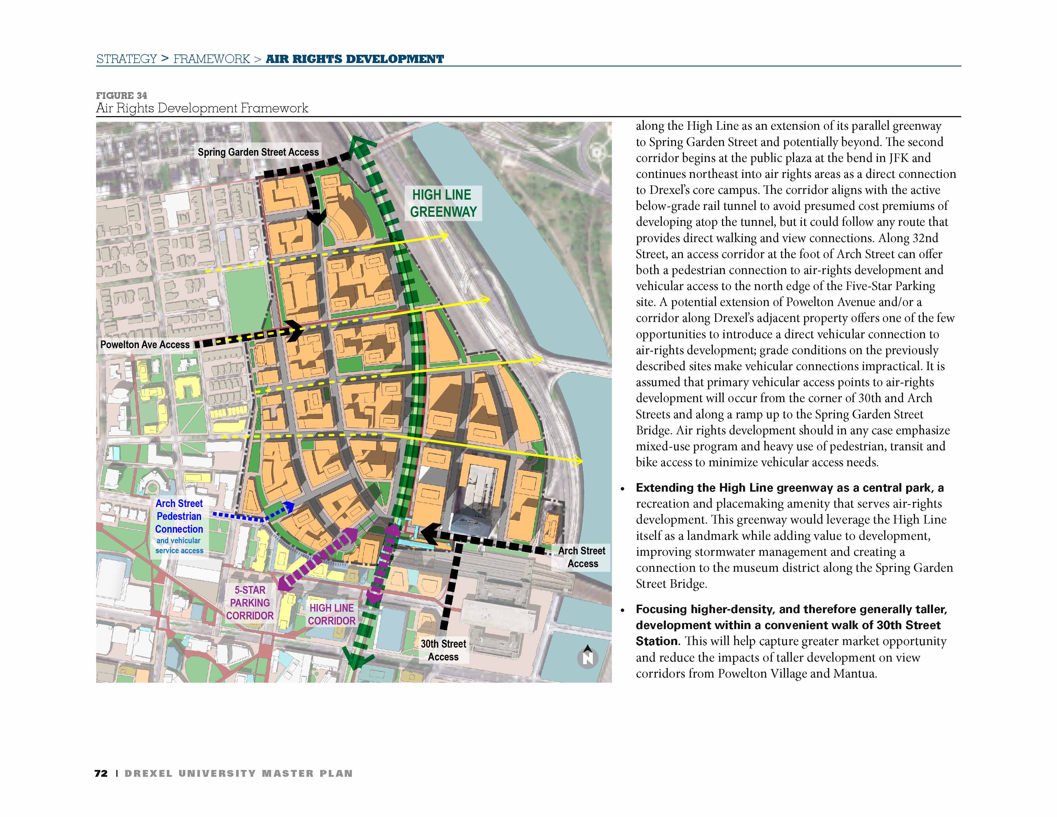
Powelton air rights, from Drexelmasterplan
Finally, let us consider Powelton Yards, the vast coach yards north of 30th St. Station. Above is the site schematic produced for Drexel's master plan; below, I translate (and expand on) the general idea in a Google Maps map. Powelton Yards is a truly vast area: capping it would yield some 30 blocks of space. The height needed to clear 30th St.'s west approach, in the southwest corner, would create an artificial hillock, hence the name I've given this area as a neighborhood: Schuylkill Hill.
Schuylkill Hill. Blue are the Drexel Master Plan parcels; yellow, my extensions; red, the DMP streets; sky blue, my extensions; and green is parks and berms.
Between the core 30th St. area (including the Innovation Neighborhood), Penn Park Place, and Schuylkill Hill, a fairly extensive gull-winged western extension of the city core is taking shape. Let us hope that we fix the mistakes of our past, and don't make new ones we'll come to regret.
_____________
*Short of sinking billions of dollars into a bypass.

Monday, March 3, 2014

Capping Vine Redux

Remember this post? Remember this picture?
Well, with the new Mormon apartment building, I thought I'd bring it back to life, and put more meat on them bones.
Here we see, in purple, the major developments near Vine between Broad and Logan Square: the Mormon Temple, their Meetinghouse, the new apartment building at 1601 Vine, the Provence, and the apartment buildings buttressing Broad and Callowhill. Under it, we see the old cap plan. Intermingled with these, we also have some additions: several mews structures to take advantage of the increased desirability, and a small park over the exit ramp at 15th and Vine.

In the cloverleaf, we build a new "Sydenham Mall" (Sydenham being the name of the interstitial street between 15th and 16th); flanking it, large buildings fronting each of the four corners. They would share mechanicals and loading docks in the cloverleaf curve; inasmuch as possible, they would cover the interchange. Retail fronting Sydenham would lead up to the Provence*; retail fronting 16th would help urbanize that street further; flex space would front 15th.

Between all of these additions, the Vine Street Expressway would be completely hidden from 12th to 21st-ish. It would become the perfect example of the proper placement of heavy transportation infrastructure in the city--grade-separated, out of mind.**
___________
*If the Provence is built. As you may recall, I noted in A Provincial "Provence" that turning the cloverleaf green is, in fact, the worst possible for it.
**Remember, in Death and Life, Jane Jacobs noted that the most marginal uses--and hence the worst land values--were (in her time) usually located next to railroad tracks; this can be expanded to include Interstates today, for various reasons. Both are heavy infrastructure. The fact of the matter is that heavy transportation infrastructure, while indubitably necessary for the city to function properly (to get imports in and exports out à la her economies trilogy), also have a depressing effect on adjacent land. My extension of this point is--one of planning's major goals should thus be minimization of this effect by making heavy transpo infra "invisible" from an urban-dynamics point of view.

Friday, February 28, 2014

My Train Of Thought Is Going Over Wind Gap, Apparently

Saw this item on Systemic Failure the other day: http://systemicfailure.wordpress.com/2014/02/24/vre-replaces-apartments-with-parking/
Progress on acquiring land in the Crossroads Business Park for the 1,500-space parking lot at the planned station is moving along more slowly. Officials had originally expected the station to be open by now, but numerous issues have popped up, with the most recent problems caused by stalled negotiations for land for the commuter parking lot.

The county had been negotiating with businessmen George Lester and Fitz Johnson, who own the property needed for VRE parking. The businessmen recently gained county approval to build 610 apartment units and commercial space next to the station site.

But the negotiations for the roughly 25 acres for the parking lot have proven fruitless. So the county recently asked the Virginia Department of Transportation to handle the property acquisition.

“They can facilitate it better,” said Spotsylvania County Administrator Doug Barnes. 
Ya think? And what's worse, there are plenty of excellent examples where it's Done Right nearby--in Arlington County, in fact.

But there is another issue buried between the lines here. 610 apartment units on a 25 acre site comes out to 24.4 units/acre. Let us simplify this to 24 u/acr, and consider that postwar "garden" apartment "barracks" are really just attached rows of duplexes or triplexes in "green" settings*. At 24 u/acr, you get (a) 12 dp/acr, or 1 duplex = 1/12 acr, and (b) 8 tp/acr, or 1 triplex = 1/8 acr. Triplexes cover less space, yielding more green space, so this complex would probably be triplexes.

Let us, by contrast, begin with the typical 25'x50' lot found in prewar suburbia, remembering of course the dictum that there is no difference between New Urbanism and prewar suburbanism. Since an acre is slightly greater than 200'x200', this implies that there are 32 lots/acre; triplexing this yields 96 u/acr, or twelve times the density of what is currently being achieved. But this is excessively dense; most railroad suburbs have emergent 50/50 homeownership/rental ratios.

Let us reserve, in line with typical consumption, 20% of our site (5 acres) for infrastructure--streets, a park, and the like. This yields 640 lots on a 25-acre site. Splitting these lots evenly, we have 320 houses and 320 plexes. Splitting the plexes evenly yields 160 duplexes and another 160 triplexes**. Summing these yields 1920 units, a whopping 315% more than the current proposal calls for. And furthermore, neighborhoods built out to this density are often just as green, and charming, as those with more green space. This implies that, past a certain amount, provision of green space is subject to diminishing returns: Just before you hit it, you get charming "green" town environments; past it, house farms.

So provision of green space is clearly not a good in and of itself. Like most anything else, it's how it's used that determines its true value. Green scraps left to fulfill zoning requirements have marginal development value and zero usage value. But modernist planning, in its flawed assertion that green space is an unmitigated good, makes no account of this. This is why house farms and towers-in-parks both tend to have the same overengineered, lawn-softened, bleakly industrial look: They are both people batteries. And because urban dynamics requires a critical mass to spark, while the lawns hide their interiors' aesthetic bleakness, they also push everything too damn far apart to spark emergent urban dynamics.

Anyway. Since the average household size today is 2.6, our 25-acre railroad suburb would yield a population of ~5000, a much fatter prize than the ~1600 the garden apartments would house, and certainly a far fatter prize than a 1500 space lot. Three other similar developments nearby would yield a nice town of 20k on 100 acres...

Modeling, the fact that, past a certain critical point, green space appears to cease to boost urbanism, and indeed, instead diminishes it needs to be considered mathematically. This critical point appears to be tied to an urbanism "critical mass". Since critical masses imply step functions, we can infer Heaviside (either it is or isn't), and can also infer that that function's discontinuity occurs at a certain percentage of green space provision. Since green space provision, by percentage, is (obviously) along the origin from (0,0) to (100,100), all we need to find is at what value green space provision, by lot, definitively hurts the formation of urban dynamics. This implies a Heaviside step from 1 (urbanism is emergent) to 0 (it is not).

Urbanism also has a clear financial buff. We need to find the nature of this buff (is it scalar? vector? etc.) and model it; knowing this information can help develop key Strong Towns tools that are not just descriptive, but predictive as well.
___________
*By stacking, not by firewalls. By firewalls, you can get du-, tri-, quad-, and hex- (6) plexes. Quadplexes by stacking (octoplexes, or 8 units, per firewall) are rare, but not unheard of; pentaplexes (5 units) by stacking and their decaplex (10 units) cousins by firewall are absent--most likely because elevator regulations start kicking in at that point.
**There are a couple of reasons for doing this. First off, different space requirements. Duplexes have more living area than triplexes in a unit shell. Secondly, this yields a Main Street of duplexes atop commercial units. But it is unreasonable to think the Main Street would consume all of the allotted duplexes.

Wednesday, February 19, 2014

Three Links

Apex Urbanism is another excellent blog in the old urbanist vein, heavily influenced by Nathan Lewis and Charlie Gardner. Still fresh, it's worth checking out.

A local blogger puts out Munson's City--lots of excellent and interesting ideas, critiques, etc.

Finally, check out the Allure of By-Lanes and Cobbled Streets Pinterest page. Beautiful photos of great urban places. This latter reminds us, especially in old urbanist contexts, how much modern regulation has actively hindered, not helped, placemaking.

Thursday, August 23, 2012

Viva la 2012 Zoning Code!

Philadelphia's new Zoning Code came into effect today.

What does that mean?

Most superficially, all of the zoning designations in the city have changed. R-10a is now RSA-5, C-2 is now CMX-2, and so forth.

But there are other important changes. The biggest of these is that the Zoning Code is now contextual.

What does that mean? Think of it as a compromise between Euclidean and form-based zoning--while the theoretical structure of the code is still Euclidean, the contextual zoning means that form-based elements are taken into consideration. RSA-5 is essentially each of the three or four different rowhouse designations under the old code mixed into a new designation; the contextual element means that new construction will ideally match existing construction elsewhere on the block (i.e. have the same setbacks, etc.). But large deviations from the norm trigger design review and (probably) rejection.

In short, the code still doesn't allow you to build a commercial addition to your residential property by right (unless your neighbors already have such additions), which is a shame, largely because while it is much less rigidly Euclidean than the old code, it still doesn't allow for the flexibility of use a fully form-based code would.

On the flip side, the new code has made densifying existing commercial corridors significantly easier. CMX-2.5, now the standard on most commercial corridors, allows for mixed-use development up to 55 feet high. 55 feet is by no means an arbitrary number: most major Philadelphia streets are either 50 or 60 feet wide, which means that CMX-2.5, when applied to its utmost, allows commercial streets to achieve a 1:1 street width-building height ratio*.

This does not bode well for midcentury commercial areas, largely because the Philadelphia variant of googie favored single-story commercial structures--essentially, strip malls even if they fronted the sidewalk. We need to undertake documentation efforts, and ensure that an outstanding handful are preserved--primarily in communities where supply and demand are already well-balanced--as well as individual examples that are exemplars of the style (such as Stein Florist at Frankford and Princeton). In this way we can retain a record of the appearance of the built environment without impeding redevelopment and densification of our commercial cores where they are most needed (e.g. along Frankford and Castor).

While the code ensures Center City can be denser and more of a skyscraper canyon than ever before with "Super" CMX-5**, it still underzones other important commercial nodes, leaving them at CMX-2.5 where a FAR-based zoning would be more appropriate. Chelten, Front and Girard, 52nd St., and Bridge-Pratt are exemplars of this issue; all are (or were) crucial commercial centers; all should (probably) be bumped up to CMX-4 (500 FAR, or five stories by right); the main difference is the lack of height limit on the latter. Germantown and Chelten is an example of a cluster of taller buildings that such an upzoning would allow emulation of. Likewise, first steps are being made towards TOD identification and implementation (although that is something that needs to be hashed out in the neighborhood plans).

With parking requirements (one of the more insidious auto subsidies), the Code, again, shows steps towards more current understandings of the role, but not a willingness to fully embrace current understanding. Rowhome parking requirements have been cut out entirely, but larger residential structures still require them, and base commercial requirements have not been changed at all (still at one spot, i.e. 250 ft2, per 1000 ft2 of commercial space). On the flipside, TOD, car sharing, bike sharing, etc., bonuses quickly, and drastically, reduce them or chop them out entirely. Good for Center City, bad for the Northeast.

I am unsure if RSA-5 is also height-contextual; I believe it partially is, due to 3rd stories on mostly 2-story blocks now needing to be stepped back. Comments have cleared this up.


...Some initial impressions on the new Zoning Code.
_______________
* Or 2:1 on Frankford and Castor Avenues in the Northeast.
** "Super" CMX-2.5 has a base FAR of 1600. For comparison, the Empire State Building has a FAR of almost exactly 3300, or double that.

Friday, August 17, 2012

"Super CMX-5"

The new Comprehensive Plan has a new subdistrict of CMX-5 (old C-5), called "Super CMX-5", which has a FAR of 1600% (allowing 16 stories with 100% lot coverage) along the Market Street corridor in Center City.

...This is around 2/3 of the existing C(MX)-5 designation, already concentrated in Center City.

It makes sense to think of it more as a new ceiling zoning designation (CMX-6?), which allows us to start thinking about expanding C(MX)-4 and -5. These significantly denser zones allow us to upzone around subway and Regional Rail stations, especially in extant commercial centers, thereby offering (obliquely) a tool to create and leverage TOD.

In other words, "Super CMX-5" (=CMX-6 for all useful intents and purposes) allows "normal" CMX-5 to be applied at e.g. Broad and Spring Garden, Broad and Washington, Broad and Girard, Broad and Lehigh, Broad and Erie, Front and Girard, and so on. It also allows CMX-4 to be applied along Chelten Ave. and 52nd St., and around Frankford, Olney, and (maybe) Wissahickon Transportation Centers.

Instead of concentrating all density in Center City, it allows us to spread it along our mass-transit system, thereby creating more use, more ridership, and (eventually) a tool for developing and re-developing along new mass-transit corridors.

(Which brings up the issue of demand- vs. development-oriented transit, but still...)

Friday, January 20, 2012

The Architecture of Wissahickon: Urban, Suburban, Midcentury, Victorian

The controversial Roxborough development proposal that caused quite a stir last week is at the edge of one of the city’s more remarkable neighborhoods. Staunchly middle-class, this neighborhood hangs tenaciously onto the slope between Ridge Avenue and the beginning of the Wissahickon Gorge, like a mining town halfway up a mountain.

It is also remarkable in that it has been continuously developed and filled out over the last century and a half, with a housing mix ranging all the way ... Continue reading at Hidden City Philadelphia.

Tuesday, January 10, 2012

Embrace and Enliven

Credit drexelmasterplan. The dream--and the reality.
The announcement last month of Drexel University’s draft master plan (by the Boston firm Goody Clancy) was a purposely subdued event, a presentation only to interested parties, with documents only later released publicly on the master plan blog.

What a treasure trove of documents they are! Three PowerPoints–a vision, a strategy, and implementation–show ... Continue reading at Hidden City Philadelphia.

Wednesday, December 14, 2011

Drexel's Master Plan Moving Forward

Drexel Master Plan "In Progress" Image: drexelmasterplan
Last Friday morning, Drexel University presented its nearly-complete master plan, developed by the Boston architecture and urban planning firm Goody Clancy, to members of the university community. We've been following the planning through the master plan's blog, which you can access HERE.

Among the first projects to break ground ... Continue reading at Hidden City Philadelphia.

Thursday, November 3, 2011

City Line Avenue, Part 1

So here we go.

Yes, I live along City Line Avenue, and like locals near and far I know there's always a Line in City Line, official designations to hell. The current state of City Line is a weird sort of urban-suburban mishmash. It's got beautiful and not-so-beautiful garden apartments, but at the same time it's got a totally autocentric assortment of '50s-'80s office parks and strip malls, the youngest of which is a power center with a Target. It's still got Philly's Saks, but the luxe quotient is going down, and has for some time: since, in fact, King of Prussia went upmarket in the late '80s and attracted Neiman Marcus and Nordstrom over a hapless center city. And with Route 1 being a primary funnel from parts Main Line way to the Schuylkill Expressway, it's a traffic nightmare.

But it could be special. It's a key link. It lies between the Ridge Avenue string of Manayunk, East Falls, and Roxborough, and the heart of the Main Line strung along Lancaster Pike, from Overbrook through Wynnewood, Ardmore, and Haverford towards Bryn Mawr (with 'Nova lying just beyond). Bala village lies just off it: an immaculately preserved commercial heart. Its communities, both urban and suburban, are exceptional in character and quality; even Wynnefield's urban heart deserves investing in. It is, in short, a perfect link for reurbanization.

City Line Avenue was never a perfect form of a suburban strip, the way e.g. Bethlehem Pike in Montgomeryville or Old Lincoln Pike in Langhorne are. Urban nodes have always existed around Overbrook and Bala stations. This offers bones for reurbanization. It has the three components of life--residents, jobs, and wares--and so offers a strong framework for densification.

How to do it? 1. It is the city line. A unified zoning code along both sides will aid efforts to reurbanize. 2. Impose a height limit--nothing too strict, but enough to ensure that megalomania for height doesn't take precedence over infill. 80 ft. (that's eight stories!) should be plenty. 3. Pay attention to the street. The avenue is the heart, and axis, of urbanization. To do it right, the avenue--on the surface--needs to provide access and movement for all forms of transportation, in a comfortable fashion. Extending a trolley line from 69th St. here (and beyond?) will help cement the district's newfound importance. And: 4. Get rid of excessive parking!

Property line to property line, the avenue varies between 80 and 130 ft. It's at its widest as it's dropping down the hill towards the Schuylkill. Normally, the width from sidewalk to sidewalk is just 85 ft. But the carriageway has four 11.25-ft through lanes and a 15-ft center turning lane, making it alone 60 ft. wide. For the carriageway, we want 4 10 ft-wide traffic lanes* and a reserved 20-ft transit median for light rail. (If the median need be wider, the through lanes can be narrowed to as little as 8.5 ft., perhaps.) Along the sides we want (a) a nice deep sidewalk (say 10 ft.), (b) a bike path on at least one side, and (c) some nice street trees, possibly in their own planting strip.


This is where the problematics come in. We can't narrow the traffic lanes any further, unless one wants to provide a completely segregated traffic or transit passage**, and so we've got to share something. We want the light rail to go fast and not be stuck idling at lights, so sharing through lanes with it is out; we've already road-dieted the through lanes as far as we can sanely go. We will thus have to integrate pedestrian and bike passage at those points of greatest compression (where the road is narrower).

We do not want any takings which involve demolition. This is wasteful. Minor takings of obsolescent setbacks, mostly in the form of small parking lots, may be useful for providing space for a full bike track. Another possibility is to create a pinch point where the road is narrowest, at 54th and City Line, which includes some preservation-worthy ca. 1920s structures as well as a large dorm (Lannon^ Hall) and some more recent rather forgettable constructions which are nevertheless part of St. Joe's campus^^.

So--where the road is narrowest, at 80 ft., we'll have 40 ft. of road lanes, a 20 ft. light rail line, and two 10 ft. sidewalks with trees in planters^^^. When we have 90 ft., we'll add at ten-ft, two lane physically separated cycle track to one side (likely the City side: the setbacks there aren't broad enough to be subdivided into building plots). And finally, at 100 ft., we can have the trees in their own green strip rather than planters. The trees, we'll assume, are London Plane or some such with nice deep root systems which will make maintenance easy.

This is, however, just the look of an urban boulevard. Next time I think about this we'll talk about urbanizing the existing built form.
________________
* What, you want to halve the lane count--are you mad? City Line already sees an AADT of, as far as I can tell, ~80k (or 20k/lane). That's a lot. Yes, the light rail should help reduce that, but we're going to still have to assume an AADT of 60k+. The narrower lanes actually slow traffic down some; this will also increase total road capacity by an incidental amount. If you still don't like it, I've got a shiny but über-expensive expressway tunnel option.
** Either a subway or an el, read. Certainly the full buildout could take one; judging by bus congestion, it could even today. But such options are very expensive, and there isn't a network to tie it into at the moment--although one would exist under Philadelphia2050.
^ Née Borgia Hall. It was renamed over the summer.
^^ A bigger administrative building holding these offices would be a wise move, as would another large dorm in the space freed up.
^^^ Since where the road is narrowest also happens to be by St. Joe's campus, we can also have the cycle path veer off into it for a while.

Friday, October 28, 2011

Why Land Use Zoning Is a Problem

Archive trawling Nathaniel Hood's blog, I found this post with this interesting argument:
To really understand the problem in 2011, you need to rewind to 2003 / 2004. St. Thomas had just spent a decade expanding its student population to around 4,500 plus, and despite new on-campus residential buildings, student populations started to creep further and further into the neighborhood.
Well-intentioned members of the City Council decided to increase restrictions on rental properties and limiting each rental home to include only up to four (4) unrelated people per household. Meaning, large 5, 6 or 7 bedroom houses could only house 4 students.
St. Paul tried to defy the laws of supply and demand. Now, this is where the law of unintended consequences kicks in. They restricted the supply of student housing while the demand remained the same. The market reacted and two things happened as a result:
  • 1. Property owners did what was reasonable and responded by splitting large homes into duplexes so they could fill up the empty space. The market had an increase in duplexes, and often times, landlords took the time to add extra attic studio apartments. This lead to the situation to actually become worse. Now, instead of 5 people in a 5 bedroom house, you now have 6 or 7 people in a recently split duplex or triplex.
  • 2. By limiting supply, the ordinance increased overall rents; thus making it more appealing to convert a single-family home into a rental unit. In a way, the 2003/2004 zoning restrictions actually motivated more homeowners to convert smaller homes into rental properties.
Now, the City Council’s next step is …
The latest moratorium would prohibit conversion of one-family homes into two- or three-family homes and two-family homes into three-family homes. The resolution also would bar one-, two- and three-family homes that are owner-occupied from being exclusively occupied by students unless a student owns the home [Link].
The problem isn’t zoning. The problem is demand.
...Except , um, your conclusion's not what your argument's telling you, bub. The natural conclusion of this argument is the problem is (land use) zoning because zoning artificially constricts supply relative to demand. (Remember that we do have to separate out zoning classification: land use and form-based zoning are two different things.) To put it another way, land use zoning is an attempt to manipulate the market--and market manipulation has some rather nasty unintended consequences. For one thing, demand doesn't go away. When supply is constricted--particularly artificially constricted--this forces the price per unit product (in this case, a student apartment) up. Which, in turn, forces a roundabout way of meeting demand. In the St. Paul case, this involved subdividing the structures in a particular way to meet demand: a particular way that actually increased the student population in the neighborhood--which has, again, become a problem, forcing more draconian supply controls. Which, in their turn, will also force developers into increasingly roundabout and circuitous ways of meeting demand. (By the way the law is worded, boarding houses  or "extended-stay hotels" are possible next steps.)

This is similar to how land-use zoning was first used to enforce segregation (by both race and class), as Charlie Gardner has shown. The difference being that then zoning restricted supply to the point that the price per unit of supply cost more than the customers' willingness to pay (no wonder poorer households flooded into the urban cores where land use was a lot less restrictive! You've gotta live somewhere.) whereas here we're dealing with a relatively monied population--or, more accurately, a population whose parents are well-monied--which, in turn, induces developers to circumvent the increasingly draconian attempts at limiting supply, which in its turn is simply making things more problematic for the surrounding neighborhood.

This St. Paul example is also an example of the natural tendency for politicians to favor (usually organized, wealthier, voting) homeowners over (usually disorganized, poorer, nonvoting) renters. It's playing a constituency game, but such games are almost never what's best for the neighborhood as a whole, since the attempt at promulgation of the status quo leads to serious market imbalances, which in turn produce deeply adverse consequences. In the hands of very competent planners, land use zoning can be made to work to promote a better city (but relatively few planners are competent enough to make it work); in the hands of politicians, it becomes akin to playing with fire: you'll get burned.

The bottom line is: Land use zoning is the problem. It's clunky, inefficient, and oftentimes subverts its own goals (unless your goal is disurbanization). Form-based zoning is much more flexible (keeping in mind Paris' zoning is essentially form-based).

There is also a jurisprudence angle to this. Our land use zoning was legally rooted in nuisance law (in essence, land use zoning is nuisance law on steroids, an attempt to zone away anything that might become a nuisance). It has deep court precedent. Because of this, the need to come up with an effective legal argument against this type of land use abuse is pressing: this zoning is an over-distortion of the market that has become its own nuisance. I would suggest that Friedrich Hayek's key observation--that the government only has access to the same amount of information as the market--would be a place to start*. But I'm not a lawyer...
__________
* Whatever else one may think of Hayek, and the Austrian school he was the grand doyen of. I'm a fan of neither: Hayek mainly winds up arguing that something is complex because it is complex (...uhhh duh?), which misses the point of complexity theory entirely, which is that complexity is a mode of explanation--a place you have to get through from here to there. In this regard, Hayek, like Smith and Keynes, is great precisely because he had one good idea, which is a lot more than most economists can claim. (In case you haven't noticed, I think economics as a discipline has gone completely off the rails. My forays into economics journals, like Urban Economics, don't help things much either. Like sociology, it has devolved to being basically formalist philosophy with kinky numbers attached.)

Friday, September 23, 2011

Quick Note on the History of Urban Planning

Nostalgia* has been behind almost every movement in urban planning.

1. City Beautiful. Nostalgia for the imperial center, as established in Mesopotamian, Greek, and Roman precedent, and retranslated in the Baroque period.
2. Decongestion (for lack of a better word). Nostalgia for the idealized medieval free city. We can see this in Ebenezer Howard's Garden Cities of Tomorrow and especially in Lewis Mumford's The Culture of Cities.
3. New Urbanism. Nostalgia for the settlement pattern nebulously called "Small Town America". Resultant reduplication of features common to this settlement pattern, with the sole exception of abandonment of the strong grid. Outgrowth of urban theory of Andrés Duany and James Howard Kunstler; informed greatly by Christopher Alexander's A Pattern Language.
4. Landscape Urbanism. Nostalgia for Modernism, primarily as an interbellum movement. Led by Charles Waldheim and James Corner. Nostalgia for Frederick Law Olmsted and Le Corbusier.
5. Traditional Urbanism. (Why is it even on here? Because it's the most cogent response to New Urbanism there is, despite its lack of attention in intellectual circles.) Nostalgia for castle towns (for lack of a better term). Nostalgia for density. Articulated best by Charles Gardner and Nathan Lewis. Informed by Jane Jacobs. Desire to harness urban forces operative in e.g. informal settlements.

There are only three major urban theorists who I can think of who are members of no movement--two of whom are Jane Jacobs and Christopher Alexander--and it's precisely their work that has stayed most relevant through the years. This is frankly because both of their work starts by correctly identifying the problem of the city (a precious rarity in urban theory) and works from there. The third theorist is, of course, Le Corbusier, whose ideas (the Radiant City) have been, by and large, discredited.
_____________
* By nostalgia I mean the idea of a historical urban form as the ideal urban form. There's nothing wrong with that--humanity has experimented with a variety of urbanisms throughout its history, and relatively few have failed. Charlie Gardner pointed out that he's trying not to romanticize, and a laissez-faire approach to urbanism should theoretically lead to a variety of urbanisms; one of my larger points, both in agreement and in contrast with him, is that there are a variety of good urbanisms. Of the schools I pointed out, traditional urbanism comes closest to reflecting this--possibly due to its youth.

Sunday, August 21, 2011

Wynnefield Heights 2: Creating Connectivity

A few days ago, I began this series with a critique of Wynnefield Heights' present conditions. The two major issues the neighborhood suffers from are a lack of interconnectivity and a poor built form. So, for this post, I am looking to make the Heights more interconnected. This is done through (a) a full streets and paths plan and (b) a transportation plan. The streets and paths ("connectivity") plan of course governs where new streets and paths need to be built, while the transportation plan governs how mass transit service runs through the Heights.

Connectivity Plan

Building Blocks
Wynnefield Heights, as it currently is, is highly disconnected, broken by arterials into a series of superblocks later split into subdivisions and towers-in-parks. From the five points at the center of Wynnefield Heights, where Monument and Ford Roads and Conshohocken Avenue all meet, no fewer than four of the radiating blocks are superblocks (see Figure A). Two of these are occupied by the mammoth Belmont Filters water plant; one is occupied by a row of towers-in-parks punctuated by a megachurch; and the last, by the Belmont Behavioral Health Center and a large Methodist facility constituting a former orphanage and a major assisted-living center.
Figure A: Current Road Network. Note disconnectedness.
Assisted-living centers, in fact, pockmark the neighborhood: besides the Methodists' Simpson House, there are also the Salvation Army's Ivy Residence, the Jews' B'rith Shalom and the more nondenominational Park Tower and Bala Nursing and Retirement Center, as well as Inglis House just across Belmont Avenue in Belmont Village. These centers have grounds of varying sizes, yet frequently have to be designed around in order to accommodate the goals of densification and urbanization here by the top of Fairmount Park.
Figure B: Road network additions (in red) help cut the superblocks down to size.
Two interventions are needed to remedy this situation: the establishment of new streets to break the walls of the superblocks down (Figure B), and the establishment of new paths to interconnect in a non-automotive capacity, particularly into Fairmount Park (Figure C). Road additions, in particular, are engineered to follow the path of least resistance: they follow alignments that either (a) remain in the public realm, (b) run along property lines, or (c) follow existing access roads (particularly in the towers-in-parks) as much as possible. By contrast, trail network additions are engineered to be more picturesque: they wind around the backs of buildings and connect disconnected fragments of the road network, and also provide pedestrian access to both the City Line and Falls bridges, neither of which currently has anything near adequate connectivity for anybody who doesn't drive, and seeks to convert a deep glen in Fairmount Park next to Neill Drive--according to a 1910 topographical map of the park, Roberts Hollow--into a hiking and picnicking area as well as restore former Fairmount Park drives Midvale and Steinberg Avenues to use.
Figure C: Multi-use trails (in yellow) to be added in and around Wynnefield Heights.
Both networks intermesh to provide a reasonably high level of neighborhood connectivity (Figure D). While certain curvilinear elements remain in this plan, pedestrian access points now come in the hundreds, rather than thousands, of feet; absurd superblocks are chopped down to size; and active park uses are bought to the section of Fairmount Park which cuts deepest into the neighborhood (i.e. Roberts Hollow).
Figure D: Streets and trails intertwine to provide greater interconnectivity.
How to Make It Happen
These extensions necessitate an expansion of the public realm in Wynnefield Heights. While there has only been one traditional way to extend the public realm--acquisition via eminent domain--in Wynnefield Heights, two other opportunities besides present themselves. These two are simply to build where the property is already public and to work out an agreement by which towers-in-parks allow public access on their already-existing streets in return for alternative compensation--such as density bonuses or a tax break. This latter method is employed as the predominant method to break up the Northern Superblock: instead of using eminent domain and transferring all the necessary private drives to the public realm, eminent domain is used only where major modifications need to be made to offer accessibility, while these public-private agreements--sort of like the City leasing rights to the existing private drive--ensure access into the heart of the superblock.

Another issue is the extreme grades from the plateau down to the Schuylkill--a drop of some 200 feet. A bridge is planned for over Roberts Hollow between tentatively-named Country Club Road and Neill Drive; this bridge allows a cutoff for people wishing to access eastern Wynnefield Heights without passing through the five points or dropping all the way down Neill Drive and winding all the way back up Conshohocken Avenue. Getting good trail access around this hollow will be tricky.

Transportation Plan

Figure E: Desire lines and proposed mass transit connections between Wynnefield Heights and the three nearest major universities. A large percentage of the occupants of multifamily housing in this neighborhood come from one of these three institutions.
Current bus transit in Wynnefield Heights is adequate for most purposes. However, it lacks a few key interconnections--particularly to nearby Philadelphia and Temple Universities. (See Figure E.) Furthermore, this lack of a natural Temple connection, coupled with the lack of a strong bypass of Roberts Hollow, forces the 38 bus to go out of its way and traverse a most circular routing of Wynnefield Heights. The long-term transportation strategy is, thus, to run an extension of either the 3 or 39 across the Strawberry Mansion Bridge and through Wynnefield Heights, improving Temple University access; and to reroute the 38 via the new cutoff around Roberts Hollow, described above; additionally, instead of heading to Wissahickon Transfer, the 38 would head up Schoolhouse Avenue past Philadelphia University and terminate instead either at Lyceum in Roxborough, Wayne and Chelten in Germantown, or at the Queen Lane Regional Rail station (see Figure F).
Figure F: First phase of a transit plan. This network uses the 38, 39, 40, and 65 to access every important Heights location.
In the long term, however, consideration must be given to the viability of a light rail line along City Line Avenue; were this to be implemented, the City Line bus patterns would be significantly altered, affecting the Heights tangentially. A bus terminal facility at the corner of Monument and St. Asaph's would replace the overlapping termini loops the 39 and 40 would have in Phase 1. The 40 would either follow Monument straight up, or run along Belmont to Ford, to make this terminus; the 39 would run up Belmont to St. Asaph's and follow that route thence. Light rail would make current 1and 65 service west of City Line and Presidential duplicative, and so the 1 would terminate at this new Cynwyd anchor, and the 65 run through it and along St. Asaph's through Bala Village and then back down towards Wynnefield. (See Figure G.) Commuter buses--currently the 44--would of course, however, continue to follow City Line; they do not have the frequency expectations of the light rail, frequent network, or crosstowns.
Figure G: A longer-term outlook for Wynnefield Heights transit. On this map, the prospective light rail line is labeled "100".
Conclusions

Wynnefield Heights, as it currently is, is a highly disconnected and suburban neighborhood. By improving street and pedestrian interconnections, and by re-examining the bus network, the Heights can be a far more interconnected--and hence urbane--place to live.

Next time I will talk about built form modifications in Wynnefield Heights.

Monday, July 11, 2011

Basics: Parking Requirements

Nearly every American zoning code takes minimum parking requirements for granted: every habitable structure has to have a minimum of so-and-so parking per unit (if residential) or square feet (if commercial or industrial). Yet this practice runs counter to international best practices. European cities, for example, are purposefully making themselves car-hostile. And changing thoughts on parking requirements are creating a patchwork in which some cities have parking minima and others parking maxima.

The major problem is that since 1950 American cities have seen auto access as a given; rather, its proper place is a luxury. Streets need to be there for service vehicles, but they don't need nearly as much space as they claim. (Japan, for example, proves that.) Automobiles are merely one mode out of many of transportation access--their usage is enforced when we create environments where there is no mass transit and other modes of personal transit (pedestrian, bike) are well-nigh suicidal, but their usage is also encouraged when we overbuild automotive infrastructure where there is great access via all other modes as well. European cities understand this. The idea of building an apartment building next to light rail, to take an example from the Times article, is reasonably urban (indeed, that is the root of transportation-oriented development), but by giving such a structure a massive parking deck for residents, you abrogate the development opportunities gained by being transit-oriented and instead merely make it transit-proximate. In an era where resources need to be shifted to better use less energy, providing a parking space per unit just doesn't make any sense.

TOD planning has helped bring about change--see places like Rosslyn, VA--but the reality is that with fewer resources we can put toward transportation better transportation planning is necessary. TOD is only an element in broader planning--and Philadelphia, and every city, for that matter, needs to start planning to ensure that every citizen has adequate transportation access to every mode, and an environment conducive to less energy-intensive modes of transportation and more gung-ho about more energy-intensive modes. In other words, the way we zone needs to make it easier to walk, ride a bike, or take the bus or train than drive.

To that end, along with the development and implementation of a 50-year transportation plan, such as Philadelphia2050, every metropolitan area in the U.S. needs to reconsider how it accommodates automobiles, through both roadway design and construction and planned transit access and network design--and through parking requirements. Parking minima should only be enacted in places where mass transit access in a 50-year timeframe is simply not a viable option, and zoning massing densities* complemented with a gradation of parking maxima relative to density, with the highest-density and closest-to-high-capacity-transit locales having no parking requirements whatsoever.** Ideally, this would be bundled with market-rate pricing of parking throughout the urban organism, such as what Market Urbanism suggests, and the complete-street/shared-space network I have previously described--a one-two punch that would effectively eliminate several hidden subsidies for cars in the urban cores and provide a long-term ridership base for mass transit and regional bike trails.
___________
* In either Euclidean or form-based frameworks.
** Philadelphia's new zoning code would have been trailblazing in enacting something not much different from this, but Center City neighborhood associations--particularly the perennial thorn-in-the-side LSNA--succeeded in having such progressive language removed from the bill, due to parking concerns. The idea that parking would be removed by removing cars from the road never seems to have been considered.