Showing posts with label Planning. Show all posts

Friday, August 7, 2015

Looking At High Speed in the Keystone Corridor

The Keystone Service is a quiet giant. A simple, more-or-less hourly regional train, it only takes an hour to get from Philadelphia to Lancaster and a bit more to Harrisburg. It also adds extra hourly trains on the most-heavily-traveled intercity railroad in North America: the Northeast Corridor between Philadelphia and New York.

It does all of this through simple, done-under-the-radar improvement of the old Pennsylvania Railroad mainline between Philadelphia and Harrisburg to 110 mph running.

Right now, Harrisburg is where improvements end, though. This is not an accident. While Norfolk Southern bypasses the former PRR mainline east of the Susquehanna, it uses it -- intensively -- to Pittsburgh. Electrification, and therefore the territory Keystone Service push-pulls can cover, also ends at Harrisburg. And finally, the terrain becomes significantly more mountainous, and the railroad more curvy, as it follows the Juniata River valley deep into core Appalachia's corduroy, up and across the Alleghenies, and back down the Conemaugh River valley.

As it stands, with more operating funds (i.e. enough to purchase a couple of trainsets, engineers, conductors, and slots) integrating a few more daily trains between Harrisburg and Pittsburgh appears perfectly viable. A push-pull setup with an electric at one end and a diesel at the other would also allow these runs to be integrated into the Keystone's existing schedule. And there is the tantalizing possibility of night trains, which Sic Transit Philadelphia discussed a couple of years ago.

And, with relatively simple improvements (bringing back the fourth track, increasing superelevation on the passenger tracks) speed can be brought up for passenger runs, making them more competitive than the Daily Pennsylvanian's current 45 mph average speed.

But that's all for regional trains using the classic track to access the hill towns, towns which have relatively high ridership due to (a) the trains arriving in the afternoon and (b) a general lack of Interstate/freeway competition in the area.* Good regional service is important, but Pittsburgh is a large city and therefore a large travel market; it sits at the crossroads of the Northeast and Midwest; if Pennsylvania wants to compete with New York's Water Level Route and get a slice of that pie for themselves, it's going to need a new passenger route built to significantly more modern standards than the old PRR line.

Through the corduroy mountains.

Keystone West

Approaching the Problem

If Keystone East is an experiment, it's one of the most successful in all of American passenger railroading. It established not only the existence of a rail travel market from a larger city to smaller ones out in its hinterland, it also established that high ridership is a function both of frequent service and a reasonable fare.

But it is also an experiment abetted by advantageous geography and the civil engineering prowess of the Pennsylvania Railroad, and when the PRR electrified their Northeast Corridor in the 1930s, the Main Line section only went to Harrisburg and Enola. Plans to electrify the Middle Division, the section through the mountains to Pittsburgh, were discussed, but came to naught with postwar dieselization.

It's also arguable Harrisburg and Lancaster play outsize cultural roles in the state. Lancaster is, after all, its eponymous county's seat and the heart and cultural center of Pennsylvania Dutch Country (there's a reason Turkey Hill's motto is "Imported from Lancaster County"!) Harrisburg is the state capital ... not much more needs to be said.

Head east down the PRR mainline from Pittsburgh and the same opportunities don't present themselves. Johnstown and Altoona are fair-sized burghs,* yes, but one data-lite argument that can be made is that the relatively greater importance of Keystone East would naturally drive a higher ridership than a similar service profile on Keystone West.

I don't buy this argument. Not because I think population doesn't matter -- it obviously does; more people means more potential riders -- but rather because it attempts to explain a particular result a particular political class doesn't like by avoiding having to deal with, you know, actual data and competent modeling. Data-lite arguments often tend to carry exceptionalist undertones, too, seeking ways any result can be construed as a "special case" instead of looking for commonalities to build generalizations. Alan Garfinkel had a thing or two to say about that kind of reasoning.

All that said, however, it is clearly not easy to get from Harrisburg west. But it may be easier than often given credit for.
The West Side

The cost of building a new line, as J. Edgar Thomson appreciated when he engineered the PRR's mainline, is a function both of its length and the relative difficulty of its construction. Length scales linearly, difficulty exponentially. This is why he decided to concentrate nearly all of the mainline's most challenging features in one spot: between Altoona and the Conemaugh River's water gaps through Laurel and Chestnut ridges to the west of Johnstown. East of Altoona, the line follows the water level route of the Juniata River; west of Chestnut Ridge, the mainline crosses the Allegheny Plateau while a low-grade freight line follows the Conemaugh down to the Kiskimentas and eventually Allegheny rivers.

Norfolk Southern currently runs heavy eastbound (uphill) trains up the Conemaugh Line and lighter eastbound and all westbound traffic along the mainline. The lines rejoin by Heinz Stadium in Pittsburgh and pretty much anything that isn't a unit train's going to originate or terminate in Conway Yard a few miles down the Ohio. This is a traffic pattern of convenience, though: were there heavier passenger service in the Pittsburgh area, the Conemaugh Line would be able (by double-tracking it again and upgrading the signaling) to bypass most of it.

What I'm getting at here is that, from Pittsburgh all the way to Conpit Jct., where the mainline and Conemaugh Line meet, it's perfectly possible to convert the mainline to a passenger line. Which is useful, seeing how it's a natural commuter and regional rail route. It also offers a useful terminus for a fast passenger route through the mountains at Latrobe, a burgh sitting snugly at the foot of Chestnut Ridge, and where the line curves from following the ridgeline and instead heads directly west.

Like Keystone East, this "Keystone West" uses the PRR's civil engineering prowess to its advantage, upgrading an existing line to high-speed standard. It also offers an easy commuter rail corridor extending from Pittsburgh either to Greensburg, Latrobe, or Johnstown, along with improved regional services along the classic corridor.

This latter is necessary because a high-speed bypass through Appalachia's Ridge and Valley province must be just that -- a bypass. Like all trellis river systems, the Juniata curves too sharply as it crosses from water gap to water gap to be useful for faster travel. Instead, the Keystone Corridor's new middle division must punch through the mountains on an extremely low-curvature corridor.
________________
* The Pennsylvania Turnpike (I-76) runs well south, along the former South Penn RR right-of-way; I-80 runs well north, and if it could avoid trees along with everything else in these parts, it probably would, too.

** The combined population of Harrisburg (49,673) and Lancaster (59,322) is 108,995; their MSA's, better for intercity planning, are 509,074 and 507,766 for 1,016,840. For Johnstown (20,978, 140,499) and Altoona (46,320, 127,089), that's 67,298 and 267,588.

Monday, June 22, 2015

A Good Problem for the El

The Market-Frankford Line has a capacity issue. It's crowded during rush hour. And its crowding isn't just in Center City, it's end-to-end. Many people use the el to connect to the NHSL, 101 and 102 trolleys, and buses points west at 69th St., and buses points northeast at Frankford and Arrot terminals transportation centers. And with a ridership of just over 190,000 ppd, it is by far SEPTA's single busiest route, one that sees a surprising 60% more riders than the Broad Street Line.

Crowding indicates the el needs more space. As heavy rail -- infrastructurally, by far the highest-capacity of all modes -- any further capacity increases must come with relatively incremental improvements to the current physical plant. Some improvements are cheaper than others. A couple can be implemented immediately; others may take a little while longer. From cheapest to most expensive, we can:

- Use longitudinal seating. This one is by far the cheapest way to increase capacity, requiring nothing more than a refurbishment of the el cars' interiors, one which (they are halfway through their design lives) they are due for soon. It's also used in several other American subways -- notably, Boston and New York. Longitudinal seating decreases seating capacity, but it makes up for it by increasing standing capacity; it's also important to notice that in the current setup, the worst crowding occurs around the doors; longitudinal seating can help alleviate that.

- Convert to automatic train control (ATC). The el, like New York's 7 and L trains, is a single line with no branching. While no US transit agency has demonstrated the expertise to more than ~25 tph with human-driven subways (the MTA tried once and it failed miserably), ATC allows trains to be programmed to run at any frequency so desired. Increasing the frequency increases the runs a given trainset can make, which in turn increases overall line capacity. Indeed, when the 7's ATC installation is finished later this year, the line's peak frequency will be 28 or 29 tph -- just shy of one every other minute.

- Use full vestibules. There's a lot of unused space between the el's train cars. Use of full vestibules -- essentially, an articulating chamber between the cars (much like the one on articulated buses) -- would add a lot of usable space within the boundaries of the train. 10% more, in fact. Fun fact: full vestibules are now found on metros in every single country that uses them ... except the US.

The problem with this is that the current equipment is halfway through its life cycle and full vestibules would have to be a design requirement for their replacements. It would also require a rethink of el trains from a triplet of married pairs back-to-back-to-back to a single six-car unit. Indeed, thinking of trains as assemblages of cars rather than unitary bodies in their own right is often cited as the main reason why the US (whose railroad engineering expertise stalled in the 1950s) doesn't use full vestibules.

One can also argue that a full-vestibuled trainset naturally locks train length in for the duration of its life cycle. But that is only an issue if we are actively pursuing infrastructure for longer trains.

- Lengthen the platforms. Another way to increase the el's train capacity is, naturally, to use longer trains! But train length is currently proscribed by the length of the system's shortest platforms: therefore, it makes sense to increase platform lengths if we want to, well, platform longer trains. This is particularly problematic on the West Philadelphia elevated, whose platforms should have been extended to handle seven- or possibly eight-car trains in the recent rebuilding; the 2nd, 5th, 8th, and 11th St el stops, which can can only platform six cars and require tunneling to increase platform lengths; and the 69th St Terminal Transportation Center, where the track design of both platform approaches may well actually preclude any lengthening. Easier are the Frankford el's shorter platforms, which are now more than 20 years old and can conceivably be rebuilt to handle longer trains during a modernization program in the not-too-distant future.

The downside of this is that, if you're already using full vestibules, the benefits of lengthening the platforms comes not when you've lengthened the shortest platform, but rather once you've replaced the trainsets with ones that take full advantage of the longer platforms. Of course, this can be spun: Great! Our new self-driving, longitudinal-seating full-vestibuled trains increase capacity by some 25%! Now we have some thirty-forty years to lengthen all the platforms so that we can run longer trains and further alleviate crowding now that the easy stuff's done!

- Build an express track. This is perhaps the most difficult of the incremental investments. While the original plan for the el was for it to run express through Center City, and the trolleys local -- the trolley tunnel from 15th to 32nd being therefore incorporatable into an express line -- PRT, the el's original builder, was never able to finish the scheme, having run out of money by the time the line reached City Hall and only able to raise enough to build half of the system for the last (and most expensive) mile. As a result, the West Philadelphia and Frankford els were never designed to incorporate an express track, and there's a fair possibility the latter may not be able to, either. (Market Street is much wider, so you've got more room to work with.)

All that said, the fact that el crowding doesn't drop off as you head further out, but is rather end-to-end, makes it useful to look at an express track (perhaps as a couple of short segments of timed overtakes?) Such a track would offer a useful second service for passengers heading to 69th St or Frankford and thereby free up local capacity for interstitial stations.

- Build an interceptor line. Not remotely incremental, this -- by far the most expensive solution of all -- builds a new line that siphons off some of the el's traffic at its source. Built as planned, a Boulevard subway would function as this: it would intercept most of the traffic on the 14 bus and near the Boulevard, as well as (assuming a convenient transfer) buses on Bustleton, Oxford, and Castor avenues, leaving primarily the 66 feeding into the el.

Interceptors would also have to function as lines in their own right. This is either a feature or a bug: by intercepting most passengers taking the train to Frankford, you've opened up a lot of capacity. Capacity that can get filled up. In fact, the Media/Elwyn and Paoli/Thorndale Lines are both arguably interceptors for the el (via the 101 and 102 for the former, and the NHSL and 105 for the latter) ... and are themselves heavily used. Essentially, patronage has expanded not just to fill the core line but the lines built to alleviate capacity by intercepting it.

The Boulevard subway was last projected to have the same passenger counts the el today "enjoys", a fair percentage being intercepted el passengers. But it's more than likely that that capacity would quickly get filled up, and the el run at capacity again.

So it's good to think of new lines, and think of new lines not just in their own right, but how they would fit into the network; but to propose a new line solely to alleviate the capacity problems of another is not so good an idea. Induced demand is just as true for mass transit as it is for cars and bikes.

Friday, June 19, 2015

A Minneapolis Councilwoman's Land-Use Masterstroke

Saw this quote in this article:
The Minneapolis policy, proposed by Council Member Lisa Bender, would eliminate all parking requirements for new residential units built within 350 feet, or about a block, of bus or rail service offering frequent, all-day service (every 15 minutes at midday). Within a quarter-mile of frequent bus service and a half-mile of frequent rail service, the policy change would eliminate all requirements for buildings with 50 or fewer housing units, and reduce them to one space per two units for projects larger than that. For developments within 350 feet of infrequent bus service—coming only 30 minutes at midday—the policy would reduce current parking requirements by 10 percent.
Mrs. Bender is truly brilliant. Not only is she proposing what is perhaps the most progressive parking reform in the country, she is doing so in such a way that ties parking to mass transit accessibility. IOW, the closer you are to mass transit, the less parking you need.

She isn't just proposing a law, she's proposing a template of a law. One that can easily be replicated anywhere with a good mass transit core.

For instance, if you applied a similar requirement here in Philadelphia, the scale of our core network is such that parking requirements would be waived entirely for the overwhelming majority of the inner city. It would look not dissimilar to Yonah Freemark's map of Chicago parking requirements.

Monday, June 15, 2015

Zoning, the Static City, The Dynamic City

At the beginning of the year, Charlie Gardner at Old Urbanist offered an academic's findings on zoning, especially where American practice is in conflict with European practice. Perhaps the most important part, however, is a paragraph buried deep in the piece:
How this exceptionally American land-use system came into being during the late 1800s and through to the 1930s is the primary focus of Hirt's book.  In chronicling this period, many apparent paradoxes present themselves: for instance, although the United States of the late 19th century prided itself on being the most democratic nation in the world, its citizens had a low level of trust in their elected municipal officials.  The progressive municipal reformers of the time might therefore have campaigned for planning to be guided by state or federal governments, but instead pushed for non-discretionary municipal-level zoning.  As Hirt observes, zoning reformers such as Lawrence Veiller argued that "zoning rules should vary as little as possible in districts that were as large as possible and that zoning relief should be granted only under a very limited set of circumstances, if at all." 
But if the planning powers were delegated from state to city, and the city was to have little power to alter the apparently infallible choices of the initial zoning commissions, who was left to actually engage in city planning?  No one, as it turns out.  Planning commissioners were seemingly intended to be little more than curators of the city zoning map, and Hirt finds, as I have also noted, that zoning maps have changed relatively little in their basic allocation of space since the 1920s.  As I've written about before, the actual policy that zoning was intended to serve was almost an afterthought, and was primarily concerned with protecting the investments of wealthy homeowners.  By default, and perhaps unintentionally, city planning (to the extent it existed at all) was turned over to the emerging highway engineering profession. 
American zoning policy, in sum, was a negative and reactive vision -- through its implementation, it viewed cities as incapable of honest and effective self-government, and by its actual regulations, it viewed urbanization as a threat to not only investments but to civic spirit and even the American way of life itself. As Hirt writes, "[t]he single-family home had the right to the city: it was always seen as being there first. It was the gracious host, the delicate victim, and the original citizen that was always haunted, followed, invaded, and taken advantage of by other housing types." In this sense, Hirt's book echoes the conclusions of Steven Conn's recent Americans Against the City: Anti-Urbanism in the Twentieth Century.
The key takeaway of this is fairly simple: American zoning was already being used as a tool to prevent redevelopment as early as the 1920s. Zoning theory, while it grew out of nuisance law and European (especially German) practice, was already being adapted to exclude rather than include -- zoning, by design, is a hyperlocally-devolved tool. Indeed, the basic idea seems to have been to zone land such that intensification of existing development was made impossible, a practice which inevitably would concentrate redevelopment in the most intensively-used areas -- and on the greenbelt edges. 

And because there was no systemic planning practice designed to rezone, it has been left to politicians' whims, which often result in downzonings once communities realize that existing zones allow more intensive land use than what currently exists, and state DOTs -- whose highway extensions (and not mass transit extensions) have been, since midcentury, what has opened new land up to development.

What is curious to note, then, is that American sprawl is driven by what is essentially a units problem. In the hard sciences, units problems rise when units are misapplied, or when they're inadvertently mixed. For example, while a velocity calculation might be mathematically simple under constant acceleration, the result has to be in the same units as the inputs (e.g. m/s, cm/s, mi/h, etc.). Mix up the units -- say, by measuring an object's weight when what you want is its mass -- and you throw your calculations off. Similarly, inappropriate aggregation can often hide more than it illuminates: this is one of Jane Jacobs' key critiques of mainstream macroeconomics, that the sovereign nation is fundamentally an inappropriate unit for economic measurements, as it almost always represents an aggregation of very much economically disparate regions. 

By over-empowering land use planning at the hyperlocal scale, we inadvertently disempower reasonable land-use planning at the scale where it matters most, as far as optimizing spatial efficiency relative to amenitization is concerned: the greater conurbation. Static land use paradigms undercut the efficacy of mass transit (as has often been pointed out at Urban Kchose); because zoning law is not designed with spatial efficiency in mind -- and, indeed, almost every solution to any given land-use problem increases spatial inefficiency -- we find ourselves unable to respond save by sprawling more ... and more ... and more.

Sometimes small-scale intensification is not aesthetically pleasing: witness D.C.'s pop-up house, which, now that one has been built, has been banned. Indeed, this has generally been zoning's modus operandi -- regulate nonconformity into nonexistence. The problem with this is, however, that at a certain level, small-scale intensification requires aesthetic flexibility. Indeed, this may be old urbanists' strongest criticism of New Urbanism: that it overfocuses on form, while underfocusing on the land-use development process -- the true locus of the sprawl process. This is perhaps where Strong Towns has come into play: it has gained traction and has been growing, as a grassroots movement, precisely because it has correctly identified the core problem: a broken process: a process that enshrines a static, rather than dynamic, vision of the city.

But here is an interesting issue, and once where there might actually be natural friction between Strong Towns and old urbanists: short of total curtailment of land use regulation (an extremely libertarian solution), while the issues in transportation engineering are clearly defined by its excessively top-down paradigm, the problems with spatial planning are caused by it being excessively bottom-up. That is, resistance to change is driven not by new inhabitants but by the ones who already live there, and have the time and energy to mount opposition (which, due to the way the playing field is skewed, is almost always effective opposition). Even very simple changes -- for example, liquidation of excessive parking regulation, making small multiunit structures legal, moderate height increases, and other examples of incremental redevelopment -- are opposed so fiercely that, outside of large urban cores where an effective development counterpresence can be built, they are unlikely to get any traction.

The long and the short of this can be summed up by saying: The current land-use planning paradigm is fundamentally broken. Moreso, it is fundamentally broken because current American regulation creates a static vision of the city, rather than a dynamic one; this fundamentally empowers interests that favor their static vision (NIMBYs) while disempowering ones whose vision is dynamic (developers). And, despite many planners' attempts to make dynamic redevelopment easier, the truth is that the discipline's entire toolkit, over-oriented towards a static vision, greatly inhibits what can be done, and yields marginal results of even the most sweeping efforts.

Monday, September 29, 2014

Kansas City Can Do It Better

(This post started as a fork from the previous post, The Streetcar Fiasco.)

Let us recall, for reference,  Width, and the Perception of Width and Multiway Boulevards, Transit Avenues.

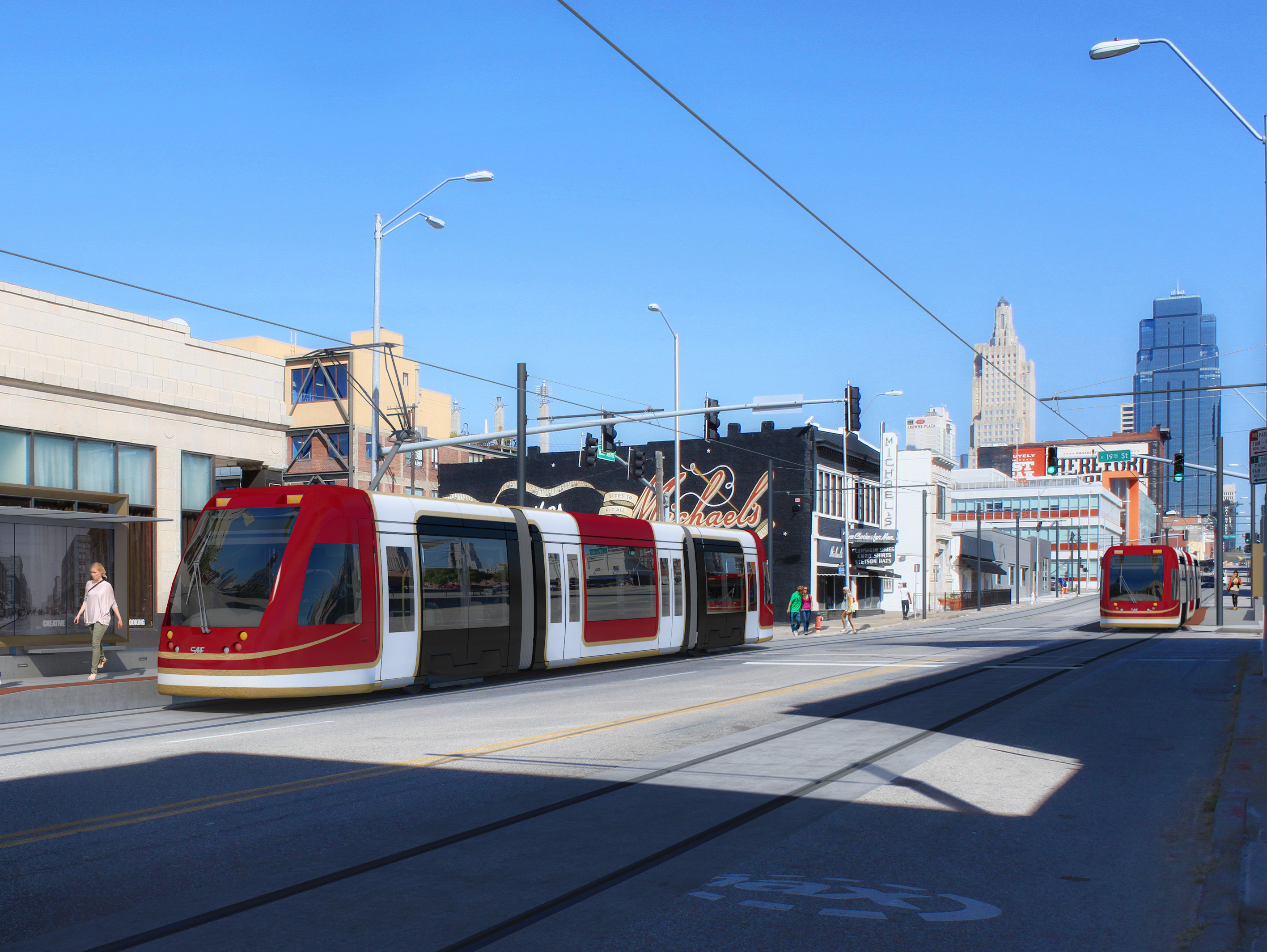
Kansas City Streetcar render
Kansas City's Main Street is only 80 feet wide -- 10 feet narrower than H Street -- but has nothing like the latter's congestion. Yet there are two southbound lanes and one northbound lane, and during "peak" periods the parking lanes turn into bus lanes. The streetcar is a mere drag-and-drop effort into the existing system.
The narrowest a street can be and still have full light rail is a mere 70 feet. At this width, several compromises have to be made, sure -- in particular, on blocks hosting stops, parking lanes need to be removed -- but they are as nothing compared to the scale of the compromises that need to be made on
60-foot streets. And remember, Kansas City's Main Street is a -- measured -- 80 feet wide.
Sample (pre-Streetmix) sections
In fact, we can have our cake here and eat it too. The nature of Kansas City's layout allows us to route core bike infrastructure on Broadway Boulevard and Grand Boulevard, which gives Main Street plenty of room to handle all of light rail's needs. Like so (with a parking space where the stop isn't).
A second option would be to kill parking spaces on one side of the street. It may be preferable to construct a street layout like this between stops. (Note that, in this layout, the parking space may also be claimed as a parklet where sufficient pedestrian energy to do so exists.)
In both, however, it becomes evident there is plenty of space for proper light rail, instead of copying a failed experiment from elsewhere in the country. More creative thinking's all that's needed.

Well, that, and a willingness to give up traffic lanes.

Friday, September 26, 2014

The Streetcar Fiasco

Streetcars have become a major fad over the past few years, ever since Portland put in theirs.
Portland Streetcar
In Portland's case, the streetcar is a pretty decent investment: it acts as a circulator overlay on a high-quality light rail system. But after they put theirs in a bunch of other cities began to construct streetcars for themselves.
H Street Line, Washington, DC
DC's H Street line was the second major streetcar; it is also the first that suggested an underlying problem. You see, H Street is supposed to be a spine corridor, linking the city's east side with its west. It thus needs to be built to a higher standard capacity than ... that.
This particular design -- at the time, novel* -- contains two catastrophic mistakes that permanently mar this line's capacity:
  1. The line has been built in a mixed traffic lane rather than be given its own dedicated lane. This reduces the streetcar's speed and makes it no better than a bigger bus on rails. Part of what makes light rail successful** is the dedicated lane. Without this lane the line is unable to bypass car congestion and thus provide the positive time differential that helped justify e.g. Salt Lake's investment.
  2. The line has been built in the outer lane. This second point makes it own strange kind of sense -- once you've decided not to build a dedicated ROW, there's something vaguely suicidal about asking passengers to run across a traffic lane unless you're willing to put carstops in, and if you're doing curb bumpouts as well, then why not put those there? However -- by putting the streetcar track in the outer lane you create conflicts between the streetcar and parallel parkers, delaying the transit vehicle for a single driver. These kinds of conflicts slow down vehicles on our country's remaining historic streetcar lines all the time -- one of the reasons Boston's Green Line is one of the most reliable is because (unlike the examples in Philly, Toronto, and San Francisco) the vast majority of the surface system lies in dedicated medians.
H Street was a difficult design challenge. The street is, surprisingly, 90 feet wide, and it is fairly congested -- its AADT hovers a little above the max capacity of a two-lane street -- and a full light-rail buildout would have likely required (among other things) taking of a parking lane significant street reconfiguration, much like 1st Street in San José, a bright spot in the VTA system.
1st Street, San José
Indeed, it is arguable that the H Street Line's optimal placement would have been for the light rail to lie between the sidewalk and the parking lanes, with a road diet reducing auto capacity just enough to convince (some) drivers to Take Other Routes. This arrangement, however, remains problematic in its own right, and is not the thrust of this post -- and I have talked about these kinds of things before.
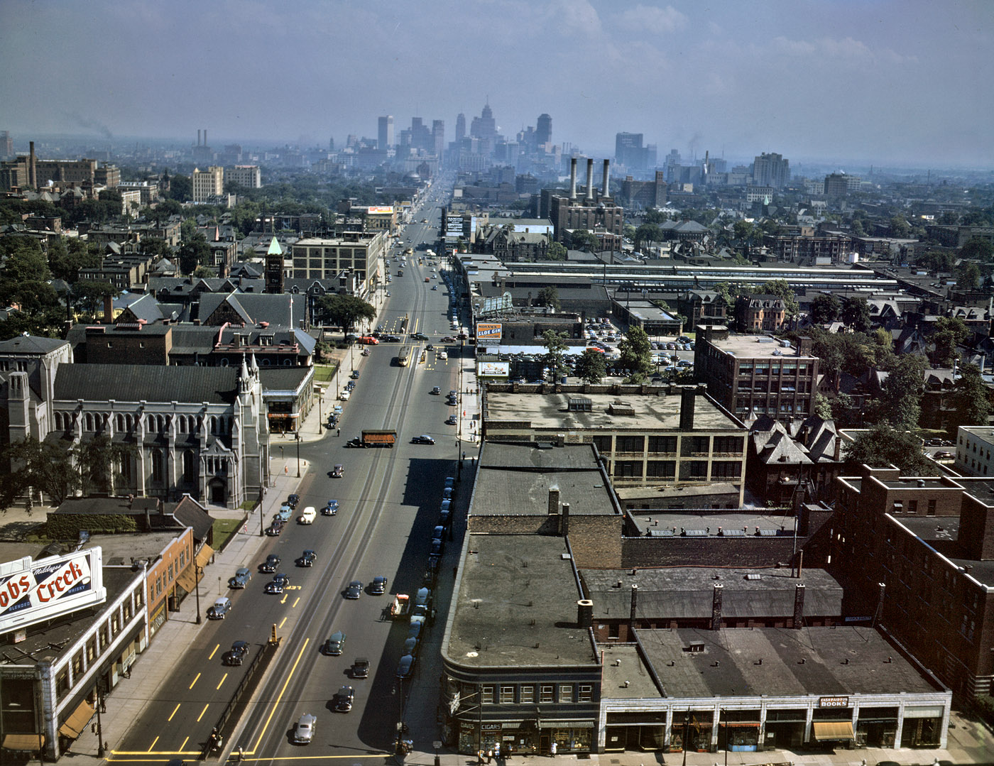
Woodward Avenue, ca. 1942. Note that even then there was little real congestion.
M-1 Streetcar plan reveals same engineering failures as H Street -- this time, with even less excuse.
At least two Midwestern cities have taken the (failed) H Street approach and applied it to themselves: Detroit and Kansas City. I haven't been to Detroit, but I will note that Woodward Avenue, which is eye-poppingly wide relative to traffic, can easily accommodate every single mode, if the designers chose to.
Kansas City Streetcar render
What is perhaps most shameful is that within these ... things ... lies the fact that the powers-that-be continue to refuse to give up any street space for cars, no matter how ridiculous the car gluttony may be *cough cough Detroit, Kansas City cough cough*, and are packaging it as a political sop to Millennials.

No. The transportation investment that would please us the most is in quality bike infrastructure. We want to ride around everywhere. Bike-friendly cities are Millennials' cities.
____________
* Portland's downtown streets are only 40 feet wide; historic streetcars ran in the middle of the street. (See, for example, Philly's trolleys.)
** And good BRT -- Cleveland's Euclid Avenue being the only such example in the United States today.

Thursday, September 25, 2014

Kansas City: Challenges

In my last post I talked about the potential Kansas City's rail alignments offer. Now I want to discuss the challenges.
Fig 1. Here we see Kansas City's essential commuter rail problem: the rail axis (red) is essentially orthogonal to the urban axis (black). The red and the black. Heh.
Locals and expatriates may have already realized the most significant challenge: namely that, unlike in e.g. Munich, Kansas City's urban core is pretty much orthogonal to the proposed regional rail core (Fig. 1). They intersect, in fact, at Union Station. This undermines the vast majority of urban-centered uses (although the Peculiar Line offers a connection to Swopes Park and hence the Zoo). To put it bluntly, Kansas City's urbanity and attractions are on a different axis entirely relative to where the trains go.

While a challenge, this is not an insurmountable problem. Union Station is adjacent to two major districts in its own right, and skillful connection-making with the Main Street corridor -- which is the urban axis, and one that desperately needs light rail -- allows for the distribution pattern, north to downtown and the River Market, and south to Westport, Country Club Plaza, and Brookside, needed to tie the regional system in with the urban system.

It is notable that the Market-Frankford Line (the El),  Broad Street Line (subway), and Subway-Surface Lines (trolleys) have similar roles in Philadelphia; our major urban playgrounds -- Fishtown/Northern Liberties, Old City, Passyunk Square, Fairmount, and University City -- are about as far afield of each other as they are of Center City proper. We often come in on Regional Rail and transfer to these other modes.*

Fig 2. Here we see the lack of routes to KCI. A potential alignment (black) is given.
A second issue (Fig. 2) is the lack of any route to Kansas City International (KCI). While several commentators point out the relative lack of cost-effectiveness of airport links in their own right, if one is "on the way" service to it is naturally justifiable. Wheeler Airport is alongside the Missouri Bluffs Line, for example; service to it is natural and intuitive. But KCI is a far larger and more important facility, and is extremely far from anything on-the-way. Reaching it would require some sort of shuttle service, if not a new alignment (redirection of the Missouri Bluffs Line? AirTrain?) of some sort.
Fig 3. Rail v. highway alignments in eastern Kansas City. Note how rail will be hard-pressed to compete on any sort of time advantage.
Finally (Fig. 3) one of the most difficult aspects of commuter rail is the fact that all the various alignments funnel into the Union Station approach in the northeast of the city proper. While not a particular issue for intercity rail, it is problematic for commuter rail -- especially the Peculiar Line -- whose run from Grandview to Union Station (Crown Center) is about 4.5 miles longer (~22 miles) than the shortest highway alignment -- US 71 to the south Loop (~17.5 miles). Assuming the train's mean velocity is 30 mph, this yields a 45 minute schedule time; contrast this with half an hour in clear traffic (50 mph average velocity**) and broadly equivalent time (42 mins) in free flow modulated by the worst stop-and-go Kansas City has to offer (average velocity: 25 mph)***.

On the coasts, we often find that riders are willing to sacrifice a certain percentage of their time for the luxury of not having to drive^. Even so, we find that commuters shy away from commutes lasting more than an hour. This leaves open the question: if the runtime into Union Station is 45 minutes, then can we ensure that the final phase of the trip (assuming it's not terminating at Crown Center) is only in the 15-minute range? This, too, can be solved by offering close connections with a light rail trunk along Main Street (as noted above)^^.

To summarize: Kansas City has significant advantages in developing a commuter rail network -- but the currently available alignments are not without their drawbacks. And since the city core was developed along streetcar trunks and grand boulevards rather than along the railroads (the paucity of railroad suburbs is notable, and is probably one of the major reasons the urban region remains relatively compact), there are going to be investment thresholds that have to be met to offer service at a quality good enough to tap the necessary markets to be justifiable.

The largest challenge is that -- in Kansas City especially -- for commuter rail to be viable, it will have to be linked into a high-quality mass transit system^^^. In much of the Midwest, here included, "quality" and "mass transit" remain a contradiction in terms.
___________
* A second aspect is that other playgrounds, further out (Mount Airy, Chestnut Hill, Manayunk, the Main Line) are well-connected with the Regional Rail system as well. Consider, then, the Turkey Creek Line, which goes to Olathe, the Independent Line to Lee's Summit, and the Lawrence Line to, well, Lawrence.
** There are random traffic lights and a not-insignificant 45 mph stretch along this route. Also people do weird things in Kansas City like follow the speed limit -- even in the 90+% of instances where it's nonsensical.
*** Maths: We are not attempting to calculate acceleration (i.e. acceleration is being considered a zero vector). Therefore the normal position equation under constant acceleration, s=vt-(at^2)/2, where s is position, v velocity, a acceleration, and t time, collapses to s=vt, which we then rebalance to t=s/v to obtain time (and convert from hours to minutes).
^ This needs to be modeled. We can see it anecdotally, and it happens often enough that it can no doubt be statistically aggregated -- but how much is it?
^^ We're going to deal with what's currently being built on Main Street soon enough.
^^^ At least in the urban core.

Wednesday, September 24, 2014

Kansas City: Potential

So for various reasons -- some of which are probably related to hormones and such -- my thoughts have taken a recent Midwestern turn. In particular, I find myself interested in the two largest cities in Missouri, a state that is essentially two Pittsburghs with a whole lot of Lancaster County in between. Being interested in commuter networks, I immediately set about applying my tried-and-true coastal methodology to these cities to see what would pop out.

Since I was there recently, my first target is Kansas City.

I found myself surprised that there was a more substantive rail network there than I'd expected; indeed, when I did some research into it I discovered that the city used to be the Midwest's second-largest rail hub (a role I had assumed fell to Omaha, the Union Pacific's historic railhead and the reason why there were once easily half a dozen mainlines traversing Iowa). Considering it, however, reveals that it makes sense: all of the four major Eastern through routes -- Pennsylvania, New York Central, Baltimore & Ohio, and Alphabet route (via the Nickel Plate) had termini in Chicago and St. Louis; while the latter's role is customarily understated, it quickly becomes evident that there were few direct linkages between it and Omaha, and four between it and Kansas City (i.e. the Burlington, Rock Island, Missouri Pacific, and Katy). Kansas City thus served as a transshipment point for freight following the transcontinental alphabet route that began with the Western Pacific and followed the Rio Grande mainline across the Rockies, spreading into a raft of competing lines from Denver east. This trade route is followed by the modern I-70 corridor. It was also a principal interchange point of the Santa Fe and a handoff point where the mainlines of the major Texas-Midwest railroads (Katy, Missouri Pacific, Frisco, and Kansas City Southern) met those of the lines following the Missouri (or heading into Iowa) heading further north, towards Omaha and Minnesota. (This trade route is followed by the I-35 corridor.) All of this made for a list of about half a dozen major railroads heading into Kansas City: the Santa Fe, Burlington Route, Rock Island, Katy, Mo-Pac, Frisco, and Kansas City Southern. Nearly all of these had lines in from multiple compass directions.
Fig 1. Major alignments into Kansas City
We can see  this in Fig. 1, which shows the identifiable freight corridors into the city. Count 'em up -- there are sixteen of them! And that doesn't count lines that were almost certainly abandoned between then and now; it is easy to forget that railroads built the Midwest, and the largest cities were -- and still are -- rail hubs.

From these we winnow out several routes. Some pass through populated areas but are too circuitous; others run out through largely rural regions. We seek out a string of populous towns en route -- town center stations generally help revitalize these places while also providing a built-in ridership base. Kansas City's metro region is relatively small -- most lines are about 30 - 40 miles long. It is also one that does not have any significant all-day congestion (indeed, it clearly has auto capacity overbuild: you're lucky to get the 8:00 AM stop-and-go on US 71 at noon out on the Schuylkill heading towards King of Prussia, and many surface streets -- especially the most heavily-engineered ones -- have desertion issues, a clear sign of excessive capacity relative to demand); we thus need seek the most direct routes to Union Station, the city's lone major rail hub. A system such as we would demand in Chicago and the large coastal cities -- frequent all-day service -- is probably beyond any reasonable resource allocation; instead, we'll have to settle for high-frequency rush-and-periphery* service on the weekdays, medium-high frequency all-day service Saturdays**, and medium-low all-day service on Sundays. Union Station is a through-station so we'll be able to immediately run regional service; this requires line balance. Finally, the station approaches -- especially immediately west -- present extremely high-grade grade-separated passenger rail alignments; we seek to make use of these.
Fig 2. Key Corridors
From this we define the eight route (plus one branch) system shown in blue on Fig. 2.
  1. Beginning along the Missouri northwest of town and moving counterclockwise, we have the Leavenworth Line, which links Kansas City, MO, with Kansas City, KS, and with Leavenworth, KS, with its prison and fort.
  2. Next we have the Lawrence Line, which runs along the Kansas River west to Lawrence, tapping KU.
  3. Down in the southwest, we have the Turkey Creek Line, which runs along the Turkey Creek corridor through the richest part of the region towards Olathe and Spring Hill. If at all possible, we would like to add a branch to Gardner to this route (however, it does not appear this is possible).
  4. Directly south of the city is the Peculiar Line, which runs along the Blue River into the city and connects with Grandview and namesake Peculiar.
  5. Southeast of that, we have the Independent Line, which connects with Independence and Lee's Summit. This route should be the most heavily-trafficked on the east side.
  6. To its northeast is the Eastside Line, which runs out to Blue Springs.
  7. Jumping across the Missouri, we have the Excelsior Line, named after its Excelsior Springs terminus. It also sports a branch north to Kearney.
  8. Finally, we have the Missouri Bluffs Line, serving an area along the Bluffs.
Projected line pairings are as follows:
  • the Turkey Springs Line is paired with the Independent Line;
  • the Leavenworth Line is paired with the Peculiar Line;
  • the Lawrence Line is paired with the Eastside Line; and
  • the Missouri Bluffs Line is paired with the Excelsior Line.
These pairings strive to match considerations of demographics and length -- that is, we're seeking a Lagrangian balance of ridership and runtime. We're also attempting to have similar runtime throughout the system -- we want no run to take more than 60 minutes. Kansas City is small enough that none should.

Next we'll talk about Kansas City's major challenges.

___________
* I.e. around "the periphery of" rush hour. We'll also need late-night service more than noontime.**
** This is because we'll be seeking to tap two markets: first, conventional commuters (particularly to Crown Center, and secondarily towards downtown via the streetcar), and second, the out-on-the-town crowd that would prefer leaving their cars at home. There's also a student market, as most of the lines have at least a midsize school along them, and the terminus of the Lawrence line is KU. Finally, in one case, there's a major prison -- Leavenworth -- and its concomitant visitors' market.

Monday, March 24, 2014

Bouncing around my mind

Pertinent to this post:

Since the PPA has no inkling of what the actual supply of any of their permit zones actually is, they routinely issue far more permits than spaces that can possibly handle those permits. Anecdotal evidence (courtesy a certain foulmouthed blogger) suggests, for example, that PPA Zone 4 currently has ~2x the permits its physical constraints can possibly handle.

Their ignorance--abetted by the fact that one has ever found a way to assess onstreet supply (until now)--is the only way they can get away with this. The implicit guarantee of a permit is that you are entitled to a place to park in the area where it's issued; if you have more outstanding residential permits than residential spaces, you've reneged on that implicit guarantee. Hint hint.

Tuesday, March 11, 2014

Rebuilding the Diesel Network

In Gunn's Great Mistake, I outlined what I believe was SEPTA's greatest failure during the Center City tunnel construction era--namely that, in the name of tunnel electrification, SEPTA eliminated all of its diesel commuter services. While it is fair to note that the tunnel construction itself consumed all of the agency's resources, and thus that staff wouldn't have wanted to touch diesel-network issues with a ten-foot pole, I am also certain that had there been a will, there would have been a way.

Now I want to concentrate, going forward, on the moves necessary to recreating this network.

1. Build the Swampoodle Connection. A Swampoodle Connection, in its strongest form, has multiple uses: Not only does it shunt the Chestnut Hill West Line down the Reading trunk, it also offers a grade-separated junction between the Northeast Corridor and the SEPTA mainline. This is because (incremental) construction of the Connection is, at each step, an order of magnitude less expensive than the expense needed to rehabilitate Pencoyd back to the standard necessary for active rail service.

Because of this, Swampoodle would naturally include another connection beyond the ones I previously noted, as it would need to provide the following paths:
  • NEC to SEPTA Mainline
  • NEC to R6 Line
  • Chestnut Hill West Branch to SEPTA Mainline
Of these, the first was never considered, but is not difficult to extend the design to add it in.

2. Work with NJ Transit for Newark Service. NJT's West Trenton proposal: After all, the combined SEPTA and NJT route reflects the Reading's Crusader alignment; a direct train would offer a secondary Philadelphia-New York commuter service to complement the very busy Keystone Service - Northeast Regional trains. With a high-quality Swampoodle Connection (and Kearny Connection at the other end), this would allow for regular Suburban Station-Newark Penn trains.

3. Integrate with Reading commuter rail. 'Nuff said.

4. Rebuild the Bethelehem Branch north of Shelly. Not only that, but extend it into Allentown. This would complement NJT's own Lehigh Valley designs. It would also help springboard work on the key (missing) regional connection from Philadelphia to Scranton and beyond.

5. Rebuild the Newtown Branch north of Fox Chase. 'Nuff said.

These projects--Swampoodle in the core supporting reconstructions and upgrading (return to service) of SEPTA's 1980 commuter rail network--would do more than just return our system (nearly) all the way to its Bicentennial extent, it would also offer a framework to hang more rail expansions from. For example:

6. Consider the Octoraro Branch. Kennett Square is a strong natural terminus, and the Brandywine Valley, while semi-rural, has centralized population centers. Reactivation of the Octoraro Branch, while requiring ROW reconstruction from Chadds Ford to Wawa, would also offer improved service to the Concordville/Painters Crossing/Brinton Lake area.

7. Consider the Perkiomen Branch. While the line up the Perkiomen has been abandoned for so long that the ROW has been severed in places, the region also holds several good conurbations crying out for better service: Collegeville, Schwenksville, and the Green Lane/Pennsburg/Red Hill complex, to name a few. Reclamation of this line would improve access to these towns.

8. Consider the New Hope Branch. While the line out of Ivyland runs through the at turns exurban and rural Buckingham Valley, New Hope, despite its size, offers strong destination value.

This list can be augmented until one runs out of historic easements. Pennsylvania has been blessed with a wealth of good, high-quality small towns--not all of them even near historic rail easements--and while their continued development is by no means tied to rail access, the access itself functions as an augment, offering improved transportation choices to these places. And the key is, a reborn diesel network functions as a framework for providing service to these awesome places. This is, more than anything, our ancestors' endowment to us: Isn't it time to make it be all it can be?

Monday, March 10, 2014

Gunn's Great Mistake

One of the major moves David Gunn made, while he was head of SEPTA back in the late '70s and early '80s, was the curtailment of its regional rail lines back into electrified territory, a move rail advocates have regretted ever since. The stated reason was that the new Center City Commuter Connection wouldn't allow scheduled diesel service, implicitly that the Reading Terminal was going to be closed down. But the problem is that this was a red herring: SEPTA's planners could have, with some clever easement tricks, retained diesel services into 30th Street or Suburban Stations. Below is one way I penciled out how.
That isn't to say there aren't structural weaknesses. Without a proper Swampoodle Connection, trains to Newtown and Newark (at minimum) are forced to use the freight alignment on the west side of the Schuylkill, for example; to avoid overloading this line, I use the Stony Creek Branch to bring trains out of Bethlehem into Philly via the R6 alignment. (A minor advantage of this setup is that it would have forced SEPTA to repair the Pencoyd Viaduct in 1986 instead of truncating the Ivy Ridge line back to Cynwyd.)

--The counter to this, though, is that the vehicles providing this service, Budd RDCs, were ending their design life at the time*, and their replacement, the SPV-2000, was so atrociously bad only the really clueless agencies ever ordered them.

--Countering that counter one would note that this was the era of the Comet I and the F40PH; again, had service retention been paramount, there would have been a way. But of course, all the political will of the era was focused on the tunnel, which leaves to us the task of picking up the pieces.

Thursday, March 6, 2014

Slumlords

(Please note that this post is the intellectual chassis for some other work.)

Philadelinquency recently ran an excellent piece on how Philadelphia’s very poor school performance holds it back. Setting aside the chicken-and-egg problem of schools and class, let us focus on the final element in this piece, an element that ties back into the blog’s long-standing focus:


Now, about your suburban slumlord who smells the gentrification coming towards his rental property he was renting out for $600/mo and collecting a string of code violations on for a decade who might decide to sell his house to a rehabber and cash out, leaving that rental at the sake of increasing valuations?  Nobody has come up with a solution for that yet.


While this is a tie-in to pieces such as this and this, there is a more fundamental problem it touches on that needs addressing: Our zoning policy has been an abysmal failure at regulating landlords. Worse still, in its zeal to separate out homeowner and renter communities, it has resulted in a nasty unintended consequence: Slumlords are the result of the system.


Consider it for a moment. Time and again, sociological studies have shown that a landlord’s investment in his rental properties is directly tied to his geographical proximity to them. A landlord who lives in the same city is more inclined to invest in his properties than one who does not; in the same neighborhood, even more so; on the same block, ditto; and by far the most likely on premises. Since a slumlord is a landlord who fails to invest in their property, we can extrapolate that they are inversely correlated with distance: that is, the closer to their properties landlords live, the less likely they are to be slumlords. We can thus extrapolate that landlords of city property who live in the exurbs are likely to be slumlords; those who live in a different metro area entirely even more so. And guess what--they are!


It is not by accident that Philadelinquency spends most of its time chasing paper trails on slumlords who live far from the city. And in many cities, “institutional investors” are quite clearly slumlords-in-waiting.


But our claim, that institutional slumlords are an unintended consequence of our land-use policy, goes quite a bit further. To make this argument, let us recall how modern zoning came to be (see here, here, and here); they were implemented precisely because the homeowners of an affluent Cleveland suburb sought to keep renters out. And so it is unsurprising that modern zoning policy disenfranchises renters; what is a bit more surprising is that the jurisprudence required to get around earlier rulings also disenfranchise small landlords. And much as other side effects of “sorting” by use disenfranchised small businesses--to the benefit of larger malls, hypermarkets, and big boxes--so too has it benefited property management firms, and institutional investors.


Property management firms--companies of the type that run garden apartments--have full-time maintenance staff associated with each property. (In the absence of a landlord, a caretaker is the next best thing.) But institutional investors need not; all they need to maintain is the portfolio. Part of this is the--not unreasonable--justification that since they handle smaller properties (i.e. houses) than property managers, a caretaker per property would be excessive. But another part is that these organizations usually have a strong financial focus, often to the detriment to the properties they’re supposed to be managing. And of course, you also have bona fide slumlords who hide behind “institutional investor” masks.


Indeed, the whole system of institutional investing seems set up to encourage financialization and transactions at the expense of property maintenance. Is it any surprise, then, that to many people, “rentals” has become a dogwhistle for “slums”? Or that small rental properties are reflexively opposed, for the same reason development is in general?


One could say that the irony is that the system has come to disadvantage the small landlord, the homeowner who wants to add a granny flat above his garage, the community-minded owner who wants to fix that house up down the street and rent it out to a nice family, in favor of the institutional investor with Wall Street connections and falling-down flats. But that is just one irony buried in a whole system of deeper ironies. Perhaps it’s time to stand up and take notice.

Tuesday, March 4, 2014

Urbanizing 30th St.

Back in September 2012 I wrote a post called The Space Between, in which I detailed urban design treatments linking the Penn and Drexel campuses together by extending the very successful Drexel platform a block further. I also proposed, more daringly, that the High Line be treated as the spine of a boulevard running from Penn Park up to JFK Boulevard, framing and defining a neighborhood-defining space.
The Space Between: Red is Drexel, Yellow UPenn, blue commercial, purple residential. Green is greenspace, and those two blue lines show the build-to lines framing 31st St. Boulevard.
The gist of this post is that: (1) Penn and Drexel ought to cooperate to extend the 32nd St. greenway/cap south to Walnut, (2) Penn needs to redevelop the 3201 Walnut garage, which has some cool features but is horrendous at street level, (3) it also needs to redevelop Rittenhouse Labs' Walnut streetwall, and (4) both have more to gain using the (quite active) High Line to define a 31st Street boulevard than mooning over a park proposal that ain't never gonna happen*. The Space Between also defines the key infrastructural and public-sector moves needed to fully urbanize the 30th Street area.

However, this area has two wings. Let us focus first on the south wing, defined by Penn Park.
Around Penn Park. The park is in green; blue is 100 Schuylkill; purple, proposed residential on air rights; yellow, Penn's land bank. In black note the extension of Schuylkill Boulevard atop the Schuylkill Expressway.
Fairly large chunks of the park, most famously the parking lot along Walnut, but also self-evidently the parking lot and disused greenswards anti-framing South, are land bank. The park was created in general to (1) sponge up and (2) help focus development around Penn's vast Schuylkill banks land bank.

But there is a second element, not as much considered: The park lies between the train tracks. While it is difficult to justify covering the western ones--at least until (unless) the Class of 1923 Ice Rink and Levy Tennis Pavilion plots are redeveloped--the Schuylkill's heavy traffic suggests that an extension of the surface avenue atop it to South is warranted. This is Schuylkill Boulevard.

And with the Boulevard, we create a platform for development. Now 30th St.'s south approach isn't just Penn Park's east edge, it's also very precious developable space sitting between it and Schuylkill Boulevard. This plan capitalizes on that by capping the NEC with five blocks--split by greenways--four of which would hold development, and one an extension of Penn Park to the river. A pedestrian bridge would also connect across the Schuylkill, onto the CSX crossing's west abutment, adding a valuable river link to these amenities. Finally, the 100 block of Schuylkill Ave. is highlighted (as if it couldn't be any more) as very valuable, riverfront, parkside developable space. Let's call this "Penn Park Place".
30th St. and Penn Park, with Drexel in red, Penn in yellow, commercial in blue, and residential in purple.
Between the space between and Penn Park Place, we have a relatively complete roadmap for redeveloping the 30th St. area: extend existing improvements south and east, and allow Penn (preferably in partnership) to redevelop the many banked parcels it owns; redevelop air rights on the riverside parcels.
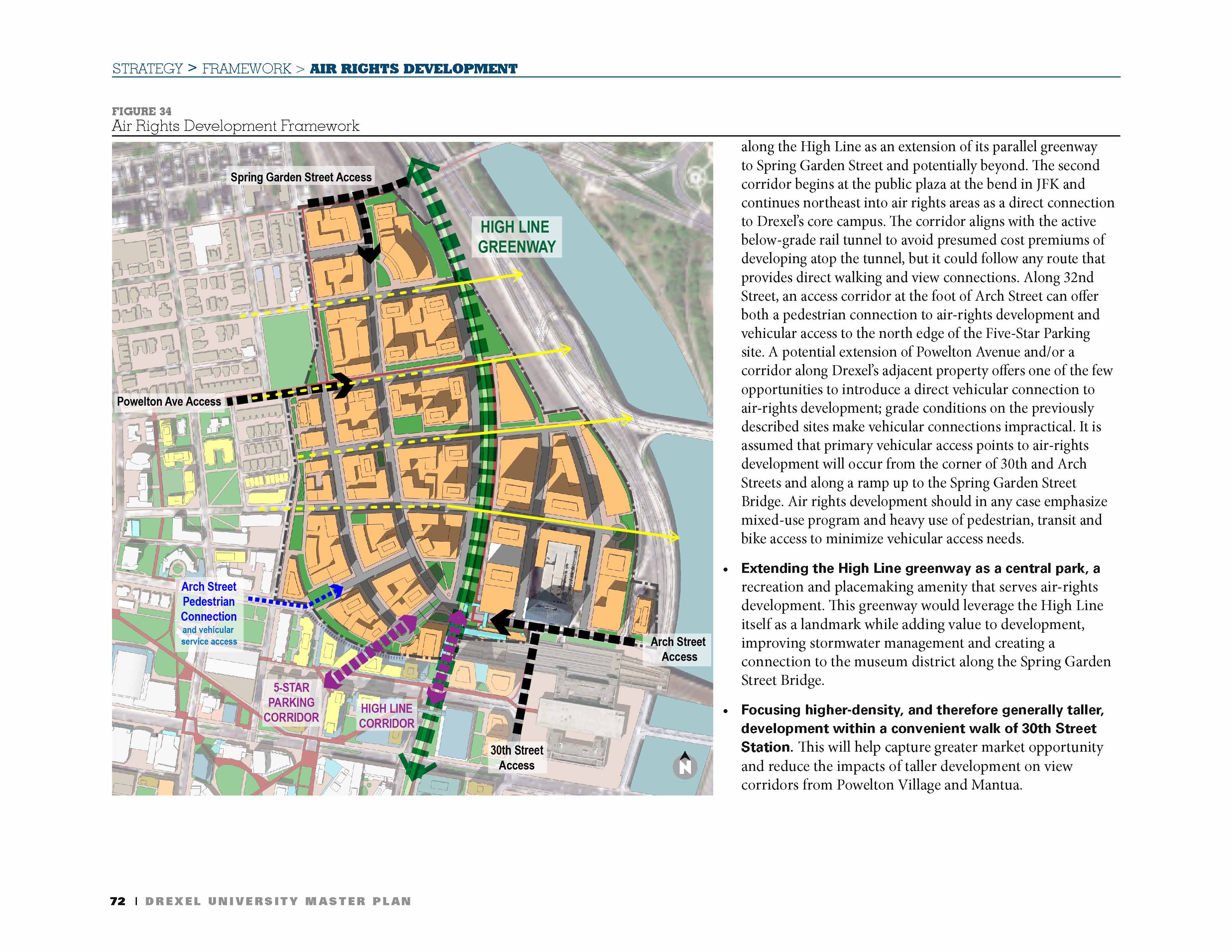
Powelton air rights, from Drexelmasterplan
Finally, let us consider Powelton Yards, the vast coach yards north of 30th St. Station. Above is the site schematic produced for Drexel's master plan; below, I translate (and expand on) the general idea in a Google Maps map. Powelton Yards is a truly vast area: capping it would yield some 30 blocks of space. The height needed to clear 30th St.'s west approach, in the southwest corner, would create an artificial hillock, hence the name I've given this area as a neighborhood: Schuylkill Hill.
Schuylkill Hill. Blue are the Drexel Master Plan parcels; yellow, my extensions; red, the DMP streets; sky blue, my extensions; and green is parks and berms.
Between the core 30th St. area (including the Innovation Neighborhood), Penn Park Place, and Schuylkill Hill, a fairly extensive gull-winged western extension of the city core is taking shape. Let us hope that we fix the mistakes of our past, and don't make new ones we'll come to regret.
_____________
*Short of sinking billions of dollars into a bypass.