So here we go.
Yes, I live along City Line Avenue, and like locals near and far I know there's always a Line in City Line, official designations to hell. The current state of City Line is a weird sort of urban-suburban mishmash. It's got beautiful and not-so-beautiful garden apartments, but at the same time it's got a totally autocentric assortment of '50s-'80s office parks and strip malls, the youngest of which is a power center with a Target. It's still got Philly's Saks, but the luxe quotient is going down, and has for some time: since, in fact, King of Prussia went upmarket in the late '80s and attracted Neiman Marcus and Nordstrom over a hapless center city. And with Route 1 being a primary funnel from parts Main Line way to the Schuylkill Expressway, it's a traffic nightmare.
But it could be special. It's a key link. It lies between the Ridge Avenue string of Manayunk, East Falls, and Roxborough, and the heart of the Main Line strung along Lancaster Pike, from Overbrook through Wynnewood, Ardmore, and Haverford towards Bryn Mawr (with 'Nova lying just beyond). Bala village lies just off it: an immaculately preserved commercial heart. Its communities, both urban and suburban, are exceptional in character and quality; even Wynnefield's urban heart deserves investing in. It is, in short, a perfect link for reurbanization.
City Line Avenue was never a perfect form of a suburban strip, the way e.g. Bethlehem Pike in Montgomeryville or Old Lincoln Pike in Langhorne are. Urban nodes have always existed around Overbrook and Bala stations. This offers bones for reurbanization. It has the three components of life--residents, jobs, and wares--and so offers a strong framework for densification.
How to do it? 1. It is the city line. A unified zoning code along both sides will aid efforts to reurbanize. 2. Impose a height limit--nothing too strict, but enough to ensure that megalomania for height doesn't take precedence over infill. 80 ft. (that's eight stories!) should be plenty. 3. Pay attention to the street. The avenue is the heart, and axis, of urbanization. To do it right, the avenue--on the surface--needs to provide access and movement for all forms of transportation, in a comfortable fashion. Extending a trolley line from 69th St. here (and beyond?) will help cement the district's newfound importance. And: 4. Get rid of excessive parking!
Property line to property line, the avenue varies between 80 and 130 ft. It's at its widest as it's dropping down the hill towards the Schuylkill. Normally, the width from sidewalk to sidewalk is just 85 ft. But the carriageway has four 11.25-ft through lanes and a 15-ft center turning lane, making it alone 60 ft. wide. For the carriageway, we want 4 10 ft-wide traffic lanes* and a reserved 20-ft transit median for light rail. (If the median need be wider, the through lanes can be narrowed to as little as 8.5 ft., perhaps.) Along the sides we want (a) a nice deep sidewalk (say 10 ft.), (b) a bike path on at least one side, and (c) some nice street trees, possibly in their own planting strip.
This is where the problematics come in. We can't narrow the traffic lanes any further, unless one wants to provide a completely segregated traffic or transit passage**, and so we've got to share something. We want the light rail to go fast and not be stuck idling at lights, so sharing through lanes with it is out; we've already road-dieted the through lanes as far as we can sanely go. We will thus have to integrate pedestrian and bike passage at those points of greatest compression (where the road is narrower).
We do not want any takings which involve demolition. This is wasteful. Minor takings of obsolescent setbacks, mostly in the form of small parking lots, may be useful for providing space for a full bike track. Another possibility is to create a pinch point where the road is narrowest, at 54th and City Line, which includes some preservation-worthy ca. 1920s structures as well as a large dorm (Lannon^ Hall) and some more recent rather forgettable constructions which are nevertheless part of St. Joe's campus^^.
So--where the road is narrowest, at 80 ft., we'll have 40 ft. of road lanes, a 20 ft. light rail line, and two 10 ft. sidewalks with trees in planters^^^. When we have 90 ft., we'll add at ten-ft, two lane physically separated cycle track to one side (likely the City side: the setbacks there aren't broad enough to be subdivided into building plots). And finally, at 100 ft., we can have the trees in their own green strip rather than planters. The trees, we'll assume, are London Plane or some such with nice deep root systems which will make maintenance easy.
This is, however, just the look of an urban boulevard. Next time I think about this we'll talk about urbanizing the existing built form.
________________
* What, you want to halve the lane count--are you mad? City Line already sees an AADT of, as far as I can tell, ~80k (or 20k/lane). That's a lot. Yes, the light rail should help reduce that, but we're going to still have to assume an AADT of 60k+. The narrower lanes actually slow traffic down some; this will also increase total road capacity by an incidental amount. If you still don't like it, I've got a shiny but über-expensive expressway tunnel option.
** Either a subway or an el, read. Certainly the full buildout could take one; judging by bus congestion, it could even today. But such options are very expensive, and there isn't a network to tie it into at the moment--although one would exist under Philadelphia2050.
^ Née Borgia Hall. It was renamed over the summer.
^^ A bigger administrative building holding these offices would be a wise move, as would another large dorm in the space freed up.
^^^ Since where the road is narrowest also happens to be by St. Joe's campus, we can also have the cycle path veer off into it for a while.

Crossing the Lines: Site, Urban, Environmental, and Transportation Planning
Showing posts with label City Line Ave.. Show all posts
Showing posts with label City Line Ave.. Show all posts
Thursday, November 3, 2011


Thursday, August 25, 2011
The Odd Situation of Bala Station
Imagine...you've got a train station right along a busy regional arterial, and clustered around that station are pre-suburban type garden apartments, along with later type office commercial and retail; behind are more single-family homes in three Census tracts with a combined population of 6,928. The station is serviced by one of the most frequent regional rail networks in the country--effectively an S-Bahn type network. You'd think that that station'd get high ridership, right? Even if mass transit ridership was a tenth of the local population, it would still be getting about 693 daily boardings. Even though later development has all been transit-proximate rather than transit-oriented? After all, even with transit-proximate development, ridership does tend to rise.
Well, meet Bala Station. All of the things I've just described...but this station has very low ridership, between 92 and 111*. It, in fact, has one of the lowest ridership counts in the system (an older ridership breakdown on Wikipedia shows Bala as having 78 boardings, while Wynnefield Avenue has 90 and Cynwyd 128**). Meanwhile, Overbrook station--also along City Line Avenue, about a mile away and nowhere near the main retail hubs, has a daily ridership of about 770.
Why does this station have such low ridership?
Two major factors converge, it seems, to undercut Bala's ridership: infrequence and invisibility. Unlike the Paoli/Thorndale Line, which has 87 daily weekday trains (along with 58 on Saturdays and 34 on Sundays), the Cynwyd Line has just 21 daily weekday trains (and none on weekends). These trains are clustered into half-hourly peak service (four trains peak with a fifth train roughly halfway between peaks and a final train an hour after the end of peak)--in short, trains for commuters without regard for any other potential wells of ridership. This infrequence is due in no small part to the brevity of the line; commuter trains once ran all the way up to Norristown along this line, but it duplicated Reading service and was thus curtailed to Ivy Ridge; in the mid-1980s it had the fourth-highest ridership of the Pennsylvania-side lines and was thus paired (as the R6) with the Norristown Reading-side line; and in late 1986 service was curtailed down to Cynwyd due to the Pencoyd Viaduct being deemed structurally unsafe.
The station's invisibility comes from it being right under the City Line Avenue bridge, with few notable walkways or driveways to the platform; even the station's lollypop*** is hard-to-see, set back a few hundred feet or so along Conshohocken State Road. People who pass by it on an irregular or semi-regular basis cannot see the platform from the road, and so it seems abandoned.
Far more damaging than its infrequency (lots of commuter rail operations realize higher per-station ridership on similar schedules) is its invisibility. It's easy to tell when a train's coming when you can see people waiting at the platform (this is pretty certainly a big boost to Cynwyd's ridership); since it appears the PRR sold the former station area a long time ago, the current platform is crowded behind garden apartments, offices, and an abandoned service station.
This abandoned service station can, however, provide the key to making Bala Station more visible once again. Being in disuse for quite some time, it might be able to be qualified as "blighted" and thus begin the process for a taking. With that property, station improvements not dissimilar to this possible site plan might be made. And with the increased ridership from better-designed stations, a case can be made for improving service frequencies--extending them longer and adding bi-hourly Saturday service, say.
And building up an improved Cynwyd Line ridership is necessary for getting more ambitious plans rolling.
______________
* The most current given ridership of the Cynwyd line is 553, and there are 5 stops on this line. 553/5 = 111. However, a ridership breakdown shows that the bulk of the boardings come from Cynwyd, so that I was moved to consider Cynwyd as offering two stations' worth of ridership (553/6 = 92). The actual ridership count for Bala Station is thus roughly 100.
** (128+90+78)*365=108,040 (annualized ridership), suggesting that these figures are a decade old. Even so, the per-station ridership breakdown is useful.
*** Name given to a distinctive type of station sign SEPTA brands its Regional Rail with.
 |
| What kind of ridership would you expect from a neighborhood like this? |
Why does this station have such low ridership?
Two major factors converge, it seems, to undercut Bala's ridership: infrequence and invisibility. Unlike the Paoli/Thorndale Line, which has 87 daily weekday trains (along with 58 on Saturdays and 34 on Sundays), the Cynwyd Line has just 21 daily weekday trains (and none on weekends). These trains are clustered into half-hourly peak service (four trains peak with a fifth train roughly halfway between peaks and a final train an hour after the end of peak)--in short, trains for commuters without regard for any other potential wells of ridership. This infrequence is due in no small part to the brevity of the line; commuter trains once ran all the way up to Norristown along this line, but it duplicated Reading service and was thus curtailed to Ivy Ridge; in the mid-1980s it had the fourth-highest ridership of the Pennsylvania-side lines and was thus paired (as the R6) with the Norristown Reading-side line; and in late 1986 service was curtailed down to Cynwyd due to the Pencoyd Viaduct being deemed structurally unsafe.
The station's invisibility comes from it being right under the City Line Avenue bridge, with few notable walkways or driveways to the platform; even the station's lollypop*** is hard-to-see, set back a few hundred feet or so along Conshohocken State Road. People who pass by it on an irregular or semi-regular basis cannot see the platform from the road, and so it seems abandoned.
Far more damaging than its infrequency (lots of commuter rail operations realize higher per-station ridership on similar schedules) is its invisibility. It's easy to tell when a train's coming when you can see people waiting at the platform (this is pretty certainly a big boost to Cynwyd's ridership); since it appears the PRR sold the former station area a long time ago, the current platform is crowded behind garden apartments, offices, and an abandoned service station.
 |
| A simple site plan for Bala Station. |
And building up an improved Cynwyd Line ridership is necessary for getting more ambitious plans rolling.
______________
* The most current given ridership of the Cynwyd line is 553, and there are 5 stops on this line. 553/5 = 111. However, a ridership breakdown shows that the bulk of the boardings come from Cynwyd, so that I was moved to consider Cynwyd as offering two stations' worth of ridership (553/6 = 92). The actual ridership count for Bala Station is thus roughly 100.
** (128+90+78)*365=108,040 (annualized ridership), suggesting that these figures are a decade old. Even so, the per-station ridership breakdown is useful.
*** Name given to a distinctive type of station sign SEPTA brands its Regional Rail with.
Tuesday, August 16, 2011
Neighborhood Mystique: Belmont Village
Neighborhood Mystique is a semi-regular series on unheralded yet handsome neighborhoods in Philadelphia.
Bounded by Belmont Avenue, City Line Avenue, and the Bala Country Club golf course, Belmont Heights is one of the City Line's smallest neighborhoods. Across from Bala-Cynwyd and close to Center City, this neighborhood has always been within easy walking or transit distance of the region's major shopping and jobs centers.
Built almost all in one go in the 1920s, Belmont Village's primary housing stock is the ubiquitous (for that time) airlite, primarily Tudor, although more Deco and Modernist looks creep in amongst newer airlites. Along Conshohocken Avenue, the Mission style, however, holds sway.
Larger apartment complexes abut interior Belmont Village's airlites along Belmont and City Line Avenues; shopping lies across the street and at the corner of Monument, Ford, and Conshohocken in nearby Wynnefield Heights. As with all City Line neighborhoods, however, the retail corridor is autocentric; redevelopment into something more pedestrian-friendly would go far in shoring this area up.
Historically, Belmont Heights is more an urban Main Line neighborhood than a suburban Philadelphia (County) neighborhood. The airlite pattern of development, like garden apartments, rose in the 1920s as a way to accommodate that new necessity, the automobile, and bring "light and air" into urban environments via the use of a deeply set-back front yard (which replaced rowhomes' rear yards) and garage-fronted alleys. It is a style that is being adapted in modern suburbia...poorly. This early attempt to accommodate the auto without having it take over a fundamentally pedestrian environment is light-years better than what we see today. As is the building quality.
Like Wynnefield, Belmont Village is today a mainly African-American middle-class enclave. Like all the City Line neighborhoods, however, there is a growing influx of young professionals moving in and maintaining stability, even as African-American populations continue to suburbanize.
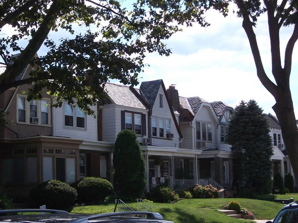 |
| Typical Belmont Village airlites |
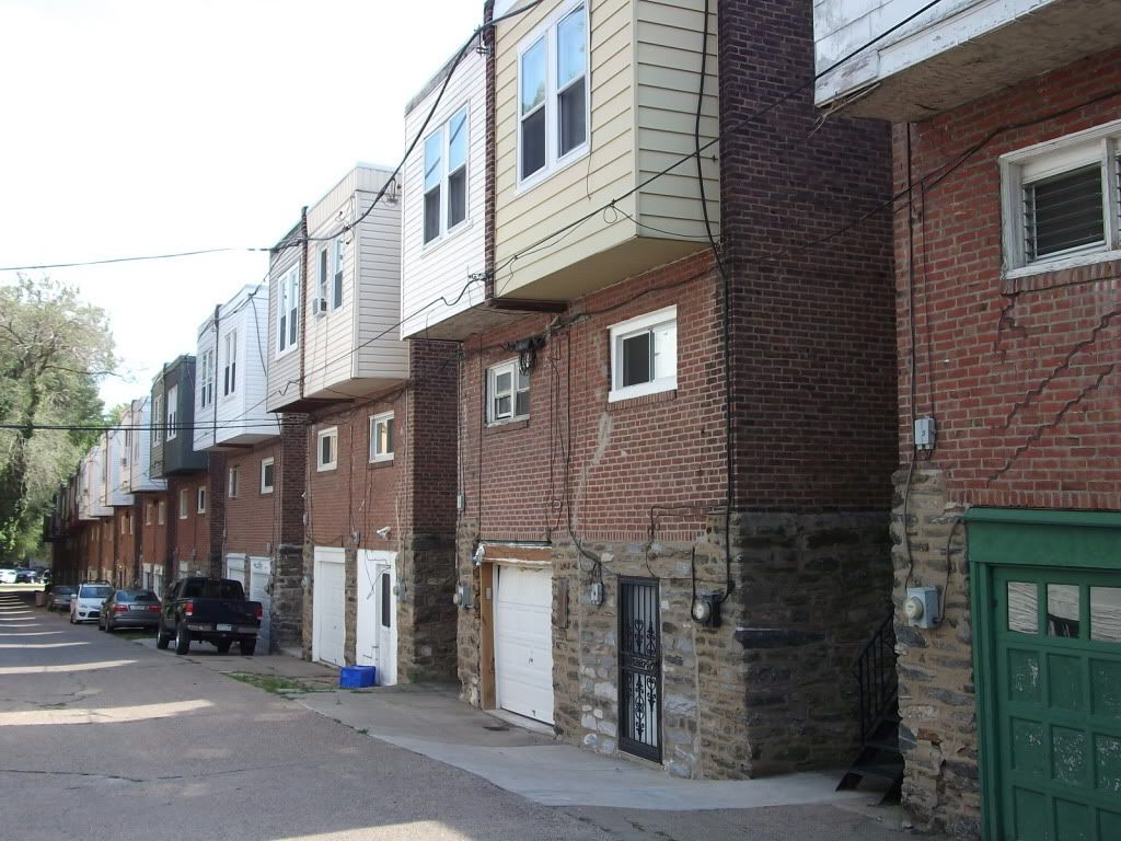 |
| Airlite rears. Notice alleyway and ground-floor garages |
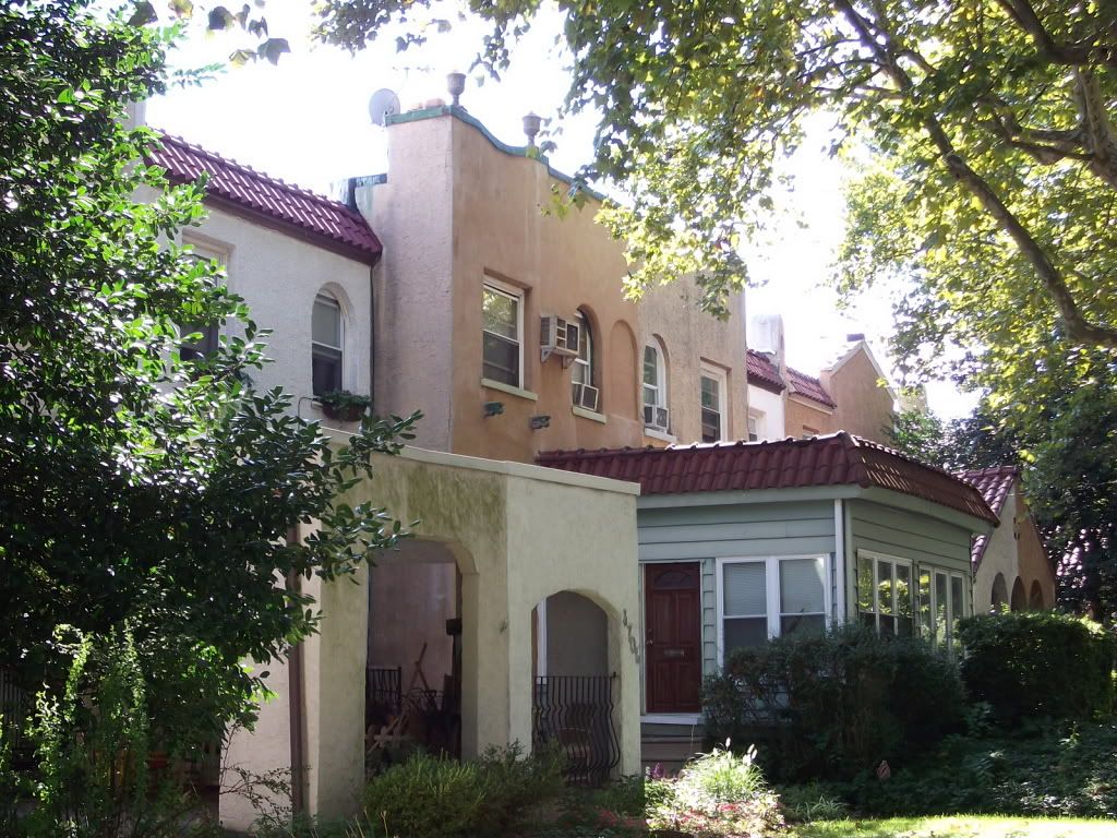 |
| Mission-style airlites along Conshohocken Avenue |
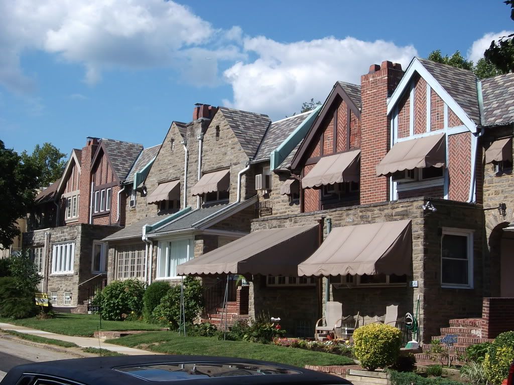 |
| A more Colonial style of airlite |
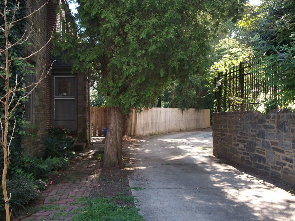 |
| An alleyway integrates into the local environment. Automotive, but not autocentric, space |
Thursday, May 19, 2011
Cemetery Heights Line

How does Yonah Freemark make his maps so sharp?
This is a no-brainer.
The Cynwyd Line is currently SEPTA's least-performing line, with 553 daily boardings, at about 184 spread over each of its three stops. This line is the black sheep of the system, being the only one serviced by a dinky, and the only one with neither off-peak nor weekend service. Politics, more than anything else, keeps the Cynwyd Line from being abandoned entirely.
This is a grand and epic waste of potential, though. The Schuylkill Expressway (I-76) is more a progression of bottlenecks than a proper Interstate, with Cemetery Heights coming in just before some of the worst jams (at City Line Avenue and the Belmont Curve). There is some space on the hill where the Pencoyd Viaduct crosses the Schuylkill Expressway for this: it is something of an engineering challenge, but it should be possible to put in a large parking garage, capable of holding about the same amount of cars as Cornwells Heights (1,600), there. This park-and-ride would be directly accessible from the Schuylkill Expressway.
Since the right-of-way is there and the catenary can easily be re-strung, the costs are primarily in laying down a mile of rail (mostly single-track), building a 240-foot-long platform, and the parking structure. Since the average above-ground parking structure costs $20,000 a space and there would be 1,600 parking spaces, this structure would cost $32 million. A million for the rail extension, five million for the platform and the slip ramp (a simple slip is all that's needed), and another ten million for budgetary padding brings the cost up to $53 million--quite large for a mile-long extension, but justified because (1) SEPTA lots are paid lots, and hence in principle profitable, and (2) the (lack of) length of this extension belies the ridership increase.
The extension would have two new stops: Belmont, a reactivation of an older stop; and Cemetery Heights, the new terminus. Belmont is projected to have 184 daily boardings--the average for the other three--but Cemetery Heights' projected daily boardings are on a par with SEPTA's largest park-and-ride, Cornwells Heights, currently at 1,104. This is a potential daily ridership increase of 1,288 to 1,841, which is 2.3 more people than currently use the line. In other words, this scheme would triple--at relatively nominal expense--the Cynwyd Line's ridership.
Per rider, the costs would break down to $41,150--high, but comparable to per-rider expenses elsewhere in the U.S. (which Alon Levy was talking about earlier today). It would have the additional benefit of incurring an addition maintenance and operating expense of essentially zero: SEPTA already has the equipment, the crew, and even the rail maintenance equipment already on its system. This expense would be one-time-only, payable by parking proceeds. The project can be completed in a single construction season--hardly enough time for delays or cost overruns. It can even in all likelihood be developed as a public-private partnership with, say, Zuritsky's Parkway Corporation: were he to pick up the garage's tab, the total per-rider cost would drop to just $8,570. And finally, it can convince a skeptical Philadelphia riding public that SEPTA is indeed serious about service expansion.
The other interesting thing about Cemetery Heights is that it lies at an important junction in Philadelphia's burgeoning bicycle network: the Pencoyd Viaduct, formerly used by the Pennsylvania Railroad to cross the Schuylkill, is being repurposed into a bikeway. It connects with the Schuylkill River Trail around Ivy Ridge and Shawmont, and it terminates into the Cynwyd Trail here. The Cynwyd Trail itself extends from Belmont Avenue in a hollow behind Westminster Cemetery to Cynwyd, and can continue to exist on the former second track of the Pennsy branch. Due to this quirk, there is a strong possibility that this station can be used as a bike-and-ride in addition to its park-and-ride capabilities. 200 spaces of bike parking at Cemetery Heights is, therefore, to be duly provided.
Subscribe to:
Posts (Atom)