Now we have two tactical urbanism tools to encourage shared streets.
1. No Parking signs. Like in Malibu, of all places. Yes, I'm serious. Wash West has the highest shared-street quotient in the city, and many of these streets have strong--signposted--No Parking regulations in place, as well as bollards preventing parallel parking on sidewalks. (In saying this, I retract my previous post on the subject: I was clearly wrong). The easiest way to make this happen, if you live on a Small Street, would be to contact your block (group) captain and request that on-street parking be removed from your block and it be turned into a shared space (a tour through Wash West may be helpful here). If that doesn't work, more...tactical solutions may be needed.
2. Pedestrian sharrows. Create a large stencil and paint it at the head of a small street.
Like so.
Friday, November 11, 2011
Thursday, November 3, 2011
City Line Avenue, Part 1
So here we go.
Yes, I live along City Line Avenue, and like locals near and far I know there's always a Line in City Line, official designations to hell. The current state of City Line is a weird sort of urban-suburban mishmash. It's got beautiful and not-so-beautiful garden apartments, but at the same time it's got a totally autocentric assortment of '50s-'80s office parks and strip malls, the youngest of which is a power center with a Target. It's still got Philly's Saks, but the luxe quotient is going down, and has for some time: since, in fact, King of Prussia went upmarket in the late '80s and attracted Neiman Marcus and Nordstrom over a hapless center city. And with Route 1 being a primary funnel from parts Main Line way to the Schuylkill Expressway, it's a traffic nightmare.
But it could be special. It's a key link. It lies between the Ridge Avenue string of Manayunk, East Falls, and Roxborough, and the heart of the Main Line strung along Lancaster Pike, from Overbrook through Wynnewood, Ardmore, and Haverford towards Bryn Mawr (with 'Nova lying just beyond). Bala village lies just off it: an immaculately preserved commercial heart. Its communities, both urban and suburban, are exceptional in character and quality; even Wynnefield's urban heart deserves investing in. It is, in short, a perfect link for reurbanization.
City Line Avenue was never a perfect form of a suburban strip, the way e.g. Bethlehem Pike in Montgomeryville or Old Lincoln Pike in Langhorne are. Urban nodes have always existed around Overbrook and Bala stations. This offers bones for reurbanization. It has the three components of life--residents, jobs, and wares--and so offers a strong framework for densification.
How to do it? 1. It is the city line. A unified zoning code along both sides will aid efforts to reurbanize. 2. Impose a height limit--nothing too strict, but enough to ensure that megalomania for height doesn't take precedence over infill. 80 ft. (that's eight stories!) should be plenty. 3. Pay attention to the street. The avenue is the heart, and axis, of urbanization. To do it right, the avenue--on the surface--needs to provide access and movement for all forms of transportation, in a comfortable fashion. Extending a trolley line from 69th St. here (and beyond?) will help cement the district's newfound importance. And: 4. Get rid of excessive parking!
Property line to property line, the avenue varies between 80 and 130 ft. It's at its widest as it's dropping down the hill towards the Schuylkill. Normally, the width from sidewalk to sidewalk is just 85 ft. But the carriageway has four 11.25-ft through lanes and a 15-ft center turning lane, making it alone 60 ft. wide. For the carriageway, we want 4 10 ft-wide traffic lanes* and a reserved 20-ft transit median for light rail. (If the median need be wider, the through lanes can be narrowed to as little as 8.5 ft., perhaps.) Along the sides we want (a) a nice deep sidewalk (say 10 ft.), (b) a bike path on at least one side, and (c) some nice street trees, possibly in their own planting strip.
This is where the problematics come in. We can't narrow the traffic lanes any further, unless one wants to provide a completely segregated traffic or transit passage**, and so we've got to share something. We want the light rail to go fast and not be stuck idling at lights, so sharing through lanes with it is out; we've already road-dieted the through lanes as far as we can sanely go. We will thus have to integrate pedestrian and bike passage at those points of greatest compression (where the road is narrower).
We do not want any takings which involve demolition. This is wasteful. Minor takings of obsolescent setbacks, mostly in the form of small parking lots, may be useful for providing space for a full bike track. Another possibility is to create a pinch point where the road is narrowest, at 54th and City Line, which includes some preservation-worthy ca. 1920s structures as well as a large dorm (Lannon^ Hall) and some more recent rather forgettable constructions which are nevertheless part of St. Joe's campus^^.
So--where the road is narrowest, at 80 ft., we'll have 40 ft. of road lanes, a 20 ft. light rail line, and two 10 ft. sidewalks with trees in planters^^^. When we have 90 ft., we'll add at ten-ft, two lane physically separated cycle track to one side (likely the City side: the setbacks there aren't broad enough to be subdivided into building plots). And finally, at 100 ft., we can have the trees in their own green strip rather than planters. The trees, we'll assume, are London Plane or some such with nice deep root systems which will make maintenance easy.
This is, however, just the look of an urban boulevard. Next time I think about this we'll talk about urbanizing the existing built form.
________________
* What, you want to halve the lane count--are you mad? City Line already sees an AADT of, as far as I can tell, ~80k (or 20k/lane). That's a lot. Yes, the light rail should help reduce that, but we're going to still have to assume an AADT of 60k+. The narrower lanes actually slow traffic down some; this will also increase total road capacity by an incidental amount. If you still don't like it, I've got a shiny but über-expensive expressway tunnel option.
** Either a subway or an el, read. Certainly the full buildout could take one; judging by bus congestion, it could even today. But such options are very expensive, and there isn't a network to tie it into at the moment--although one would exist under Philadelphia2050.
^ Née Borgia Hall. It was renamed over the summer.
^^ A bigger administrative building holding these offices would be a wise move, as would another large dorm in the space freed up.
^^^ Since where the road is narrowest also happens to be by St. Joe's campus, we can also have the cycle path veer off into it for a while.
Yes, I live along City Line Avenue, and like locals near and far I know there's always a Line in City Line, official designations to hell. The current state of City Line is a weird sort of urban-suburban mishmash. It's got beautiful and not-so-beautiful garden apartments, but at the same time it's got a totally autocentric assortment of '50s-'80s office parks and strip malls, the youngest of which is a power center with a Target. It's still got Philly's Saks, but the luxe quotient is going down, and has for some time: since, in fact, King of Prussia went upmarket in the late '80s and attracted Neiman Marcus and Nordstrom over a hapless center city. And with Route 1 being a primary funnel from parts Main Line way to the Schuylkill Expressway, it's a traffic nightmare.
But it could be special. It's a key link. It lies between the Ridge Avenue string of Manayunk, East Falls, and Roxborough, and the heart of the Main Line strung along Lancaster Pike, from Overbrook through Wynnewood, Ardmore, and Haverford towards Bryn Mawr (with 'Nova lying just beyond). Bala village lies just off it: an immaculately preserved commercial heart. Its communities, both urban and suburban, are exceptional in character and quality; even Wynnefield's urban heart deserves investing in. It is, in short, a perfect link for reurbanization.
City Line Avenue was never a perfect form of a suburban strip, the way e.g. Bethlehem Pike in Montgomeryville or Old Lincoln Pike in Langhorne are. Urban nodes have always existed around Overbrook and Bala stations. This offers bones for reurbanization. It has the three components of life--residents, jobs, and wares--and so offers a strong framework for densification.
How to do it? 1. It is the city line. A unified zoning code along both sides will aid efforts to reurbanize. 2. Impose a height limit--nothing too strict, but enough to ensure that megalomania for height doesn't take precedence over infill. 80 ft. (that's eight stories!) should be plenty. 3. Pay attention to the street. The avenue is the heart, and axis, of urbanization. To do it right, the avenue--on the surface--needs to provide access and movement for all forms of transportation, in a comfortable fashion. Extending a trolley line from 69th St. here (and beyond?) will help cement the district's newfound importance. And: 4. Get rid of excessive parking!
Property line to property line, the avenue varies between 80 and 130 ft. It's at its widest as it's dropping down the hill towards the Schuylkill. Normally, the width from sidewalk to sidewalk is just 85 ft. But the carriageway has four 11.25-ft through lanes and a 15-ft center turning lane, making it alone 60 ft. wide. For the carriageway, we want 4 10 ft-wide traffic lanes* and a reserved 20-ft transit median for light rail. (If the median need be wider, the through lanes can be narrowed to as little as 8.5 ft., perhaps.) Along the sides we want (a) a nice deep sidewalk (say 10 ft.), (b) a bike path on at least one side, and (c) some nice street trees, possibly in their own planting strip.
This is where the problematics come in. We can't narrow the traffic lanes any further, unless one wants to provide a completely segregated traffic or transit passage**, and so we've got to share something. We want the light rail to go fast and not be stuck idling at lights, so sharing through lanes with it is out; we've already road-dieted the through lanes as far as we can sanely go. We will thus have to integrate pedestrian and bike passage at those points of greatest compression (where the road is narrower).
We do not want any takings which involve demolition. This is wasteful. Minor takings of obsolescent setbacks, mostly in the form of small parking lots, may be useful for providing space for a full bike track. Another possibility is to create a pinch point where the road is narrowest, at 54th and City Line, which includes some preservation-worthy ca. 1920s structures as well as a large dorm (Lannon^ Hall) and some more recent rather forgettable constructions which are nevertheless part of St. Joe's campus^^.
So--where the road is narrowest, at 80 ft., we'll have 40 ft. of road lanes, a 20 ft. light rail line, and two 10 ft. sidewalks with trees in planters^^^. When we have 90 ft., we'll add at ten-ft, two lane physically separated cycle track to one side (likely the City side: the setbacks there aren't broad enough to be subdivided into building plots). And finally, at 100 ft., we can have the trees in their own green strip rather than planters. The trees, we'll assume, are London Plane or some such with nice deep root systems which will make maintenance easy.
This is, however, just the look of an urban boulevard. Next time I think about this we'll talk about urbanizing the existing built form.
________________
* What, you want to halve the lane count--are you mad? City Line already sees an AADT of, as far as I can tell, ~80k (or 20k/lane). That's a lot. Yes, the light rail should help reduce that, but we're going to still have to assume an AADT of 60k+. The narrower lanes actually slow traffic down some; this will also increase total road capacity by an incidental amount. If you still don't like it, I've got a shiny but über-expensive expressway tunnel option.
** Either a subway or an el, read. Certainly the full buildout could take one; judging by bus congestion, it could even today. But such options are very expensive, and there isn't a network to tie it into at the moment--although one would exist under Philadelphia2050.
^ Née Borgia Hall. It was renamed over the summer.
^^ A bigger administrative building holding these offices would be a wise move, as would another large dorm in the space freed up.
^^^ Since where the road is narrowest also happens to be by St. Joe's campus, we can also have the cycle path veer off into it for a while.
Tuesday, November 1, 2011
Expressway Caps
Columbus has an interesting expressway cap on High Street. Check it out.
While the Tribune blog bloviated over its similarities to Columbus' former (lost) Union Station--alas, poor Union Station--for planners that's not the key takeaway: instead, the key takeaway is that it is very much possible (though not cheap) to build light freeway caps. (This one cost just under $10 million.) The other takeaway is that a freeway cap need not be just for recreational land use. Boston, I'm looking at you.
Instead of a fully underground, Big Dig-type scenario, the Columbus example gives us some counter-ideas. When it is necessary--for whatever reason*--to run a sunken expressway through an urban area (usually due to the inertia of one already existing), it would be far better--and cheaper--to mitigate the impact by deploying these cap structures--or more accurately, in most cases, salable cap slabs.
In either case, the interventions are different than the major interventions that usually involve acquiring an Interstate's air rights: in those cases, space for full cores needs to be found, and anchored on solid ground. In this case, however, the structures are diminutive enough--single story commercial, townhouses, walkups, or possibly retail with a townhouse or walkups atop--that they need only basic infrastructural hookups (electricity, plumbing, and fiber)** that can be routed through the cap--no need for such expenses as elevators. Additionally, well-known green roof installation techniques can be used to add grass to whatever open space local zoning laws require in the rear of the property, please; a low wall (about 10 ft.) separates the livable space from the transportation space. With caps another possibility may be to provide a cap base along an entire city block that e.g. garden apartments can be built on. Unlike the cap concept, however, this concept would become a full tunnel and necessitate ventilation equipment somewhere on site.
This is the first of the two concepts I whipped up for this post. The Vine Street Expressway is a sunken highway dividing--despite the crossing frequency--Center City from North Philly. The sunken section runs from 10th St. to 22nd St., or 12 blocks (with 13 spans). It additionally passes by Logan Square, a pretty dismal City Beautiful mess anchored by an excessively autocentric traffic circle. This model proposes closing open caps currently situated between 18th and 21st Sts, and providing for small commercial or multipurpose salable slab space alongside each of the other bridges. As time goes on, cap additions between these caps can completely conceal the expressway's existence at street level.
This is the second. Where the Vine Street Expressway is ideal for more fly-by-night and urbanist interventions, Society Hill is ideal for something more closely approximating garden apartments, as the image explains.
____________
* And usually it's not, from a technical perspective. Big Dig-type projects should usually be opposed on principle (pork-barrel automotive spending): what I am proposing here is a mitigation strategy when expressway closure has already wormed out of the picture, or for retrofitting of existing sunken expressways.
** Electricity for climate control and cooking as well as power; plumbing means fresh water and sewer hookups; fiber allows for phone, cable, and Internet.
| High Street cap from the sky |
| High Street crossing the cap. Look, ma! No expressway! |
![]() |
| Such as these slabs in this unfinished development. |
![]() |
| Click it to see it in all its glory! |
![]() |
| Oooh shiny. Clicky. |
____________
* And usually it's not, from a technical perspective. Big Dig-type projects should usually be opposed on principle (pork-barrel automotive spending): what I am proposing here is a mitigation strategy when expressway closure has already wormed out of the picture, or for retrofitting of existing sunken expressways.
** Electricity for climate control and cooking as well as power; plumbing means fresh water and sewer hookups; fiber allows for phone, cable, and Internet.
Friday, October 28, 2011
Why Land Use Zoning Is a Problem
Archive trawling Nathaniel Hood's blog, I found this post with this interesting argument:
This is similar to how land-use zoning was first used to enforce segregation (by both race and class), as Charlie Gardner has shown. The difference being that then zoning restricted supply to the point that the price per unit of supply cost more than the customers' willingness to pay (no wonder poorer households flooded into the urban cores where land use was a lot less restrictive! You've gotta live somewhere.) whereas here we're dealing with a relatively monied population--or, more accurately, a population whose parents are well-monied--which, in turn, induces developers to circumvent the increasingly draconian attempts at limiting supply, which in its turn is simply making things more problematic for the surrounding neighborhood.
This St. Paul example is also an example of the natural tendency for politicians to favor (usually organized, wealthier, voting) homeowners over (usually disorganized, poorer, nonvoting) renters. It's playing a constituency game, but such games are almost never what's best for the neighborhood as a whole, since the attempt at promulgation of the status quo leads to serious market imbalances, which in turn produce deeply adverse consequences. In the hands of very competent planners, land use zoning can be made to work to promote a better city (but relatively few planners are competent enough to make it work); in the hands of politicians, it becomes akin to playing with fire: you'll get burned.
The bottom line is: Land use zoning is the problem. It's clunky, inefficient, and oftentimes subverts its own goals (unless your goal is disurbanization). Form-based zoning is much more flexible (keeping in mind Paris' zoning is essentially form-based).
There is also a jurisprudence angle to this. Our land use zoning was legally rooted in nuisance law (in essence, land use zoning is nuisance law on steroids, an attempt to zone away anything that might become a nuisance). It has deep court precedent. Because of this, the need to come up with an effective legal argument against this type of land use abuse is pressing: this zoning is an over-distortion of the market that has become its own nuisance. I would suggest that Friedrich Hayek's key observation--that the government only has access to the same amount of information as the market--would be a place to start*. But I'm not a lawyer...
__________
* Whatever else one may think of Hayek, and the Austrian school he was the grand doyen of. I'm a fan of neither: Hayek mainly winds up arguing that something is complex because it is complex (...uhhh duh?), which misses the point of complexity theory entirely, which is that complexity is a mode of explanation--a place you have to get through from here to there. In this regard, Hayek, like Smith and Keynes, is great precisely because he had one good idea, which is a lot more than most economists can claim. (In case you haven't noticed, I think economics as a discipline has gone completely off the rails. My forays into economics journals, like Urban Economics, don't help things much either. Like sociology, it has devolved to being basically formalist philosophy with kinky numbers attached.)
To really understand the problem in 2011, you need to rewind to 2003 / 2004. St. Thomas had just spent a decade expanding its student population to around 4,500 plus, and despite new on-campus residential buildings, student populations started to creep further and further into the neighborhood....Except , um, your conclusion's not what your argument's telling you, bub. The natural conclusion of this argument is the problem is (land use) zoning because zoning artificially constricts supply relative to demand. (Remember that we do have to separate out zoning classification: land use and form-based zoning are two different things.) To put it another way, land use zoning is an attempt to manipulate the market--and market manipulation has some rather nasty unintended consequences. For one thing, demand doesn't go away. When supply is constricted--particularly artificially constricted--this forces the price per unit product (in this case, a student apartment) up. Which, in turn, forces a roundabout way of meeting demand. In the St. Paul case, this involved subdividing the structures in a particular way to meet demand: a particular way that actually increased the student population in the neighborhood--which has, again, become a problem, forcing more draconian supply controls. Which, in their turn, will also force developers into increasingly roundabout and circuitous ways of meeting demand. (By the way the law is worded, boarding houses or "extended-stay hotels" are possible next steps.)
Well-intentioned members of the City Council decided to increase restrictions on rental properties and limiting each rental home to include only up to four (4) unrelated people per household. Meaning, large 5, 6 or 7 bedroom houses could only house 4 students.
St. Paul tried to defy the laws of supply and demand. Now, this is where the law of unintended consequences kicks in. They restricted the supply of student housing while the demand remained the same. The market reacted and two things happened as a result:
Now, the City Council’s next step is …
- 1. Property owners did what was reasonable and responded by splitting large homes into duplexes so they could fill up the empty space. The market had an increase in duplexes, and often times, landlords took the time to add extra attic studio apartments. This lead to the situation to actually become worse. Now, instead of 5 people in a 5 bedroom house, you now have 6 or 7 people in a recently split duplex or triplex.
- 2. By limiting supply, the ordinance increased overall rents; thus making it more appealing to convert a single-family home into a rental unit. In a way, the 2003/2004 zoning restrictions actually motivated more homeowners to convert smaller homes into rental properties.
The latest moratorium would prohibit conversion of one-family homes into two- or three-family homes and two-family homes into three-family homes. The resolution also would bar one-, two- and three-family homes that are owner-occupied from being exclusively occupied by students unless a student owns the home [Link].The problem isn’t zoning. The problem is demand.
This is similar to how land-use zoning was first used to enforce segregation (by both race and class), as Charlie Gardner has shown. The difference being that then zoning restricted supply to the point that the price per unit of supply cost more than the customers' willingness to pay (no wonder poorer households flooded into the urban cores where land use was a lot less restrictive! You've gotta live somewhere.) whereas here we're dealing with a relatively monied population--or, more accurately, a population whose parents are well-monied--which, in turn, induces developers to circumvent the increasingly draconian attempts at limiting supply, which in its turn is simply making things more problematic for the surrounding neighborhood.
This St. Paul example is also an example of the natural tendency for politicians to favor (usually organized, wealthier, voting) homeowners over (usually disorganized, poorer, nonvoting) renters. It's playing a constituency game, but such games are almost never what's best for the neighborhood as a whole, since the attempt at promulgation of the status quo leads to serious market imbalances, which in turn produce deeply adverse consequences. In the hands of very competent planners, land use zoning can be made to work to promote a better city (but relatively few planners are competent enough to make it work); in the hands of politicians, it becomes akin to playing with fire: you'll get burned.
The bottom line is: Land use zoning is the problem. It's clunky, inefficient, and oftentimes subverts its own goals (unless your goal is disurbanization). Form-based zoning is much more flexible (keeping in mind Paris' zoning is essentially form-based).
There is also a jurisprudence angle to this. Our land use zoning was legally rooted in nuisance law (in essence, land use zoning is nuisance law on steroids, an attempt to zone away anything that might become a nuisance). It has deep court precedent. Because of this, the need to come up with an effective legal argument against this type of land use abuse is pressing: this zoning is an over-distortion of the market that has become its own nuisance. I would suggest that Friedrich Hayek's key observation--that the government only has access to the same amount of information as the market--would be a place to start*. But I'm not a lawyer...
__________
* Whatever else one may think of Hayek, and the Austrian school he was the grand doyen of. I'm a fan of neither: Hayek mainly winds up arguing that something is complex because it is complex (...uhhh duh?), which misses the point of complexity theory entirely, which is that complexity is a mode of explanation--a place you have to get through from here to there. In this regard, Hayek, like Smith and Keynes, is great precisely because he had one good idea, which is a lot more than most economists can claim. (In case you haven't noticed, I think economics as a discipline has gone completely off the rails. My forays into economics journals, like Urban Economics, don't help things much either. Like sociology, it has devolved to being basically formalist philosophy with kinky numbers attached.)
Wednesday, October 26, 2011
PLVI Drift
PLVI stands for Peak Land Value Intersection--that is, where, in the city, the rents are costliest. It is, for all intents and purposes, the "center" of the city.
And, like the magnetic North Pole, it drifts. It can drift obliquely slightly, but this drift tends to favor the direction of the favored quarter. If the favored quarter is the west, it drifts in a westerly direction; if it's southeast, southeasterly. Sometimes accidents of geography can really nail it down, but it seems to head a couple of blocks further every generation or two.
Because High--later Market--Street was cluttered with market sheds for most of Philadelphia's early history, the PLVI, "directed" as it is by the elite in their favoritism patterns, favored Chestnut. At the time of the Revolution, the best evidence suggests it was at 2nd and Chestnut. Philadelphia's early financial district grew up along the 400 block of Chestnut, placing the PLVI there. By the fin-de-siècle, the largest department stores clustered around 8th and Market (Strawbridge & Clothier, Gimbel Brothers, and Lit Brothers), making that the PLVI, and by the 1920s it had jumped west to the corner of Broad and South Penn Square (City Hall), and thence migrated south to Broad and Chestnut, which is where Jane Jacobs found it (in her critique of it being the home of banks and not much else). It moved to 15th and Market not long after her writing, and then to 17th and JFK by the 1980s, when the postmodern skyscrapers were built--most recently the Comcast Center.
Bacon predicted it would move to 30th Street Station, which it is doing (slowly). The PLVI sat around City Hall for the first half of the 20th century in part because it was the point of maximal transportation access: the Reading Terminal and the Pennsylvania's Broad Street Station, to varying degrees of literalness, abutted the building. When Suburban replaced Broad as the Pennsy's main commuter station, and 30th Street its main intercity station, this all but guaranteed a long term westward movement of the PLVI. Something similar happened in New York, where Midtown Manhattan developed between Grand Central and Penn Station.
So what kinds of examples can you find in your city of PLVI drift? Former PLVIs are etched into the architecture. Where was the financial district located when your city was founded? A hundred years later? Two? Philadelphia, being one of the oldest major cities in the U.S., has more history to draw on than most--but that does not necessarily mean its PLVI drifted the furtherest.
And, like the magnetic North Pole, it drifts. It can drift obliquely slightly, but this drift tends to favor the direction of the favored quarter. If the favored quarter is the west, it drifts in a westerly direction; if it's southeast, southeasterly. Sometimes accidents of geography can really nail it down, but it seems to head a couple of blocks further every generation or two.
Because High--later Market--Street was cluttered with market sheds for most of Philadelphia's early history, the PLVI, "directed" as it is by the elite in their favoritism patterns, favored Chestnut. At the time of the Revolution, the best evidence suggests it was at 2nd and Chestnut. Philadelphia's early financial district grew up along the 400 block of Chestnut, placing the PLVI there. By the fin-de-siècle, the largest department stores clustered around 8th and Market (Strawbridge & Clothier, Gimbel Brothers, and Lit Brothers), making that the PLVI, and by the 1920s it had jumped west to the corner of Broad and South Penn Square (City Hall), and thence migrated south to Broad and Chestnut, which is where Jane Jacobs found it (in her critique of it being the home of banks and not much else). It moved to 15th and Market not long after her writing, and then to 17th and JFK by the 1980s, when the postmodern skyscrapers were built--most recently the Comcast Center.
Bacon predicted it would move to 30th Street Station, which it is doing (slowly). The PLVI sat around City Hall for the first half of the 20th century in part because it was the point of maximal transportation access: the Reading Terminal and the Pennsylvania's Broad Street Station, to varying degrees of literalness, abutted the building. When Suburban replaced Broad as the Pennsy's main commuter station, and 30th Street its main intercity station, this all but guaranteed a long term westward movement of the PLVI. Something similar happened in New York, where Midtown Manhattan developed between Grand Central and Penn Station.
So what kinds of examples can you find in your city of PLVI drift? Former PLVIs are etched into the architecture. Where was the financial district located when your city was founded? A hundred years later? Two? Philadelphia, being one of the oldest major cities in the U.S., has more history to draw on than most--but that does not necessarily mean its PLVI drifted the furtherest.
Development of Philadelphia
Philaphilia and Philly Bricks, with their love of historical images, give us two looks at the development of Philadelphia from more or less the same vantage point.
In 1707 the city had just been founded, and this view shows how it was still basically just a small country town, built entirely in an area that is easy to walk around: south of Arch, north of Spruce, and east of 4th. Most of it was on the Old City side of Dock Creek (thus explaining Elfreth's Alley's age). Notice the building placement: it is not random. Since time immemorial, blocks--especially planned blocks--have had their first buildings built in the middle of the block, and as time progressed, to the edges (which became the most valuable properties) and deep into the core, nested around a series of ever-narrower alleys. The residential parts of Wash West preserve this structure quite well.
Looking at this mid-nineteenth-century view of this same spot, the pattern of densification can clearly be seen, with most blocks bi- and trisected by alley networks of varying complexity. Furthermore, the first major intervention to the grid is visible: Dock Street, following the old Dock Creek, curves around, sweeping inland. The creek's headwaters were at what is today 4th and Market; Dock Street, however, terminates around 3rd and Sansom (about 1.5 blocks southeast). This is because the land value along Market and (especially) Chestnut* is so high that the expense of eliminating interventions can be borne by the landowners--typically banks and financiers--looking to locate at the center of the action.
__________
* Philadelphia's PLVI at this time was essentially the 400 block of Chestnut.
In 1707 the city had just been founded, and this view shows how it was still basically just a small country town, built entirely in an area that is easy to walk around: south of Arch, north of Spruce, and east of 4th. Most of it was on the Old City side of Dock Creek (thus explaining Elfreth's Alley's age). Notice the building placement: it is not random. Since time immemorial, blocks--especially planned blocks--have had their first buildings built in the middle of the block, and as time progressed, to the edges (which became the most valuable properties) and deep into the core, nested around a series of ever-narrower alleys. The residential parts of Wash West preserve this structure quite well.
Looking at this mid-nineteenth-century view of this same spot, the pattern of densification can clearly be seen, with most blocks bi- and trisected by alley networks of varying complexity. Furthermore, the first major intervention to the grid is visible: Dock Street, following the old Dock Creek, curves around, sweeping inland. The creek's headwaters were at what is today 4th and Market; Dock Street, however, terminates around 3rd and Sansom (about 1.5 blocks southeast). This is because the land value along Market and (especially) Chestnut* is so high that the expense of eliminating interventions can be borne by the landowners--typically banks and financiers--looking to locate at the center of the action.
__________
* Philadelphia's PLVI at this time was essentially the 400 block of Chestnut.
Tuesday, October 25, 2011
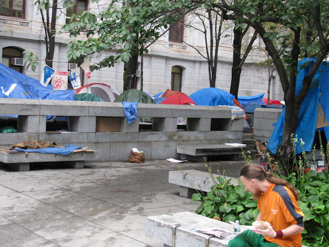
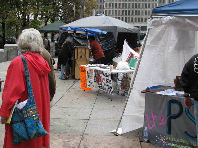
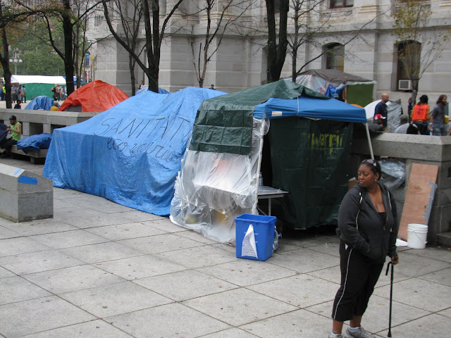
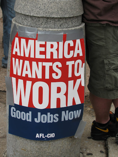
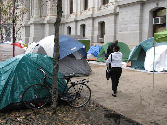
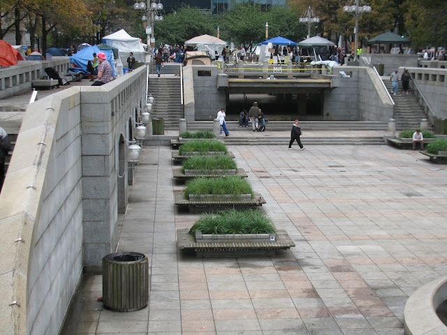
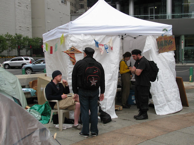
Photopost: Occupy Philly as Spontaneous Urbanism, Pt. I
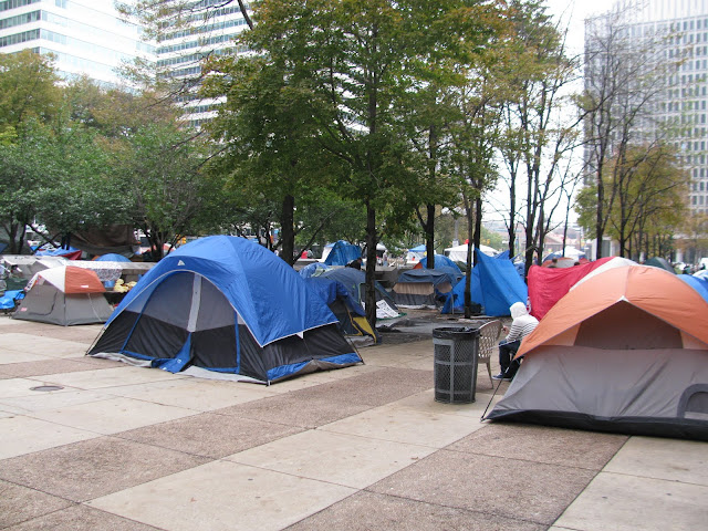
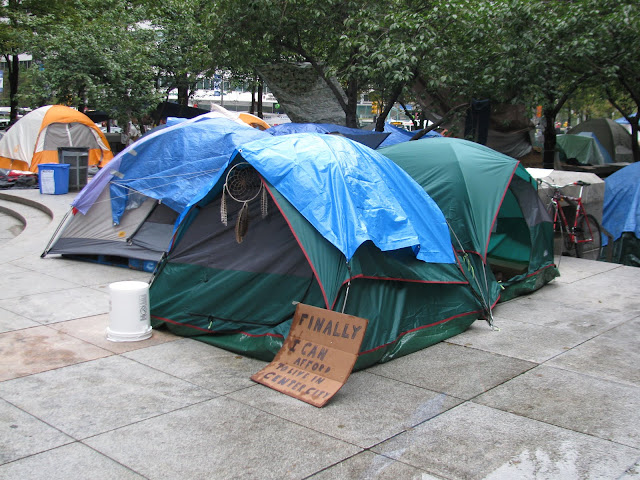
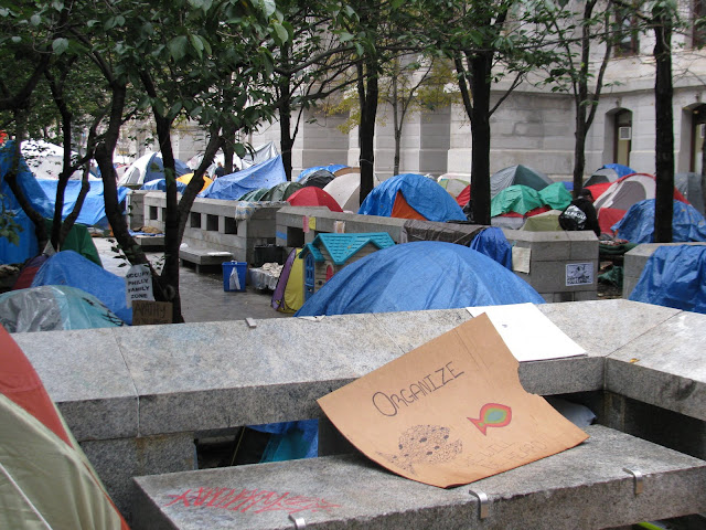
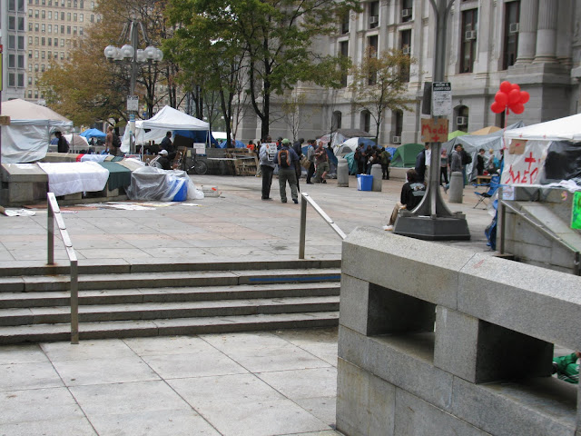
The Occupy movement has been getting increasing traction and airtime over the past few months, and roughly a month ago (already?) now a branch set up in Center City Philadelphia. Occupy Philly lays on the landscape of Dilworth Plaza, and occupies it the way a Mediterranean city a hillside.
The reason Occupy's tent city is emergent is because it is assembled from a fairly standard collection of individual units (tents), combined together in a highly complex and nonstandard order. It has both the virtues of high interconnectivity and quiet streets, achieved through a natural dual-level street hierarchy. The primary streets are, however, curved slightly and bend along City Hall's façade: the only perfectly straight road is the one between Market Street and City Hall's portal, currently being used as an amphitheater for voicing grievances.
So, without further ado, pictures!
That's all for this post. Next post I'll be documenting changes to the site in the week elapsed.
The reason Occupy's tent city is emergent is because it is assembled from a fairly standard collection of individual units (tents), combined together in a highly complex and nonstandard order. It has both the virtues of high interconnectivity and quiet streets, achieved through a natural dual-level street hierarchy. The primary streets are, however, curved slightly and bend along City Hall's façade: the only perfectly straight road is the one between Market Street and City Hall's portal, currently being used as an amphitheater for voicing grievances.
So, without further ado, pictures!
| South entrance |
| Looking towards the core. Note how broad path is being built over |
| South fountain area. The dry fountain seems to be a staging space |
| The library |
| This view shows the concentration of density around the City Hall portal |
| Looking north along a wider path |
| The art farts' corner...supposedly |
| A series of major plazas mark the north side of the Occupy Philly site now |
| Sharp boundary between urbanized and non-urbanized |
| Work ongoing. Foreground guy has a rather lackadaisical attitude... |
| Registration tents at the entrance to the site, 15th and Market |
| Sanitation tent just off the Market Street path |
| Amen, bro! |
| The city: the densest section is on the south side of the site |
| Looking towards a more pastoral north side |
| The homeless tent is surprisingly well away from the action. It is, however, on the main path right now. |
| Occurring urbanization. Lower tent densities, a slightly more pastoral vibe. |
| A yawning expanse between the edge of the urbanized area (approximately where I stood) and the north services area. |
| Looking south across this expanse |
| The sunken "waiting room" for transit--a space shied away from, even by Occupiers |
| Tents with a view seem to be in demand |
| The north services area |
| Far from the centers of the site--the Market Street area and the north services area--the libertarians set up camp at 15th and JFK. |
Thursday, October 20, 2011
Fixing the FRA
Although there are a handful of trolls who believe otherwise, the consensus opinion that the regulatory body of the Federal Railroad Administration is largely, if not wholly, broken and that, as such, a radical reformation of the body--such as from a regulatory body to a booster body, or perhaps a planning body--if not its outright elimination, is needed. This opinion is shared among people with substantive transportation expertise, from hobbyists and prospective entrants (e.g. moi) into the field, to practitioners, and on up to the very freight railroads the current FRA regulations are most forgiving to. The FRA question of a decade ago may have been does it work?, but now that the answer no, it does not has been widely agreed, the question has to become how to change it?, or, more brusquely, how to fix it?
The first problem in this question is how many people even know it is a problem, outside of the community that has to deal with it regularly? Not many. The FRA is one of several sub-silos in the highly disciplinary decadent U.S. Department of Transportation; it reports to the Secretary of Transportation and displays little cross-departmental communication with its kin, the Federal Transit Administration (FTA) and Federal Highway Administration (FHWA)*. As such, it is part of the Cabinet and thus the Presidency. But compared to the EPA, which is a huge fish, and constantly bounding across the line of what constitutes 'good' and 'bad' regulation, it is insignificant unto nothing. Very few people would even realize that stripping the FRA of its regulatory power would have done something. But since the body politic the FRA puts into practice is, compared to peer agencies, such as the relevant agency in Australia (whatever it is), or the international standard of the UIC, which governs everything from the light, speedy trains of Western Europe and Japan to the massive and heavy trains of Russia and China, archaic at best and plain old atavistic at worst, the FRA is a major impediment to badly-needed change in American railroads--both in the arenas of passenger and freight.
Thus the first issue we have to deal with is outreach. And not just one type of outreach. The FRA is so broken for so many reasons--and appears to exist now merely to perpetuate itself rather than being in thrall to a corporate or labor interest--that a case for why the FRA should be stripped of its regulatory power, if not outright done away with can most likely be made to cater to every political ideology imaginable. Very few regulatory agencies get to be such total failures as to manage that. Let us now concentrate on some of the more general ones.
For Republicans. The vast majority of modern rail technology is developed overseas, in UIC-compliant situations. If you want to privatize passenger rail service, you'll need to ensure that the American rail regulatory body is equipped to handle the maximal amount of rail technologies current available. As it stands, the FRA's sacred cows guarantee it can only handle a relatively minimal amount, and little--if not none--of which can be readily used for profitable private passenger rail. To pursue a viable privatization agenda, thus, the regulatory power of the FRA must be stripped. (This should be particularly effective on Mica.)
For Democrats. Regulation needs to be revisited from time to time to test its effectiveness. Ineffective regulation is detrimental to the needs of a country as a whole (just as a lack of regulation in situations where safety is legitimately needed). By this standard, our railroad safety regulation is outdated and ineffective. The U.S. has the worst--by a long shot--per capita railroad crash fatality rate in the developed world, despite a regulatory agenda supposedly engineered to ensure safety. Furthermore, the entire field of railroad technology in the U.S. is relatively outdated and falling behind, with offerings by Bombardier, Alstom, Siemens, and Kawasaki outstripping what even the GE GEVO is capable of, much less EMD. Passenger rail technology, as an industry in the U.S., is nonexistent: we have to import all real expertise in the field. It would appear that, in the direction the FRA is currently heading, passenger rail safety will be attained only by virtue of its nonexistence. Do we want that? Elimination of passenger rail would force all intercity transportation onto highways and through airports, which are already strained enough as it is. By contrast, the haunting ruins of an era when rail was the normative mode of intercity transportation lie all around us. Shuttered stations, grand stations ill used. Given where we expect our intercity transportation to go in the next few years, this is an entire infrastructure lay slack that can be picked up again--but again--our regulatory body ensures that this infrastructure lays slack, by forcing us to use obsolescent technology which has not been able to be profitably provided native to the U.S. for over a generation--since the end of the Budd Company. The only way to be able to pick up this slack, and bring fallow infrastructure back to active use--is to eliminate the bad regulation forcing its slackness. Worse, the FRA has gone rogue, refusing to listen or study any regulatory solutions used anywhere else in the world. Why should we trust a rogue organization with vital safety regulation? Bring the FRA under heel, strip it of its current policy, and impose a UIC-compliant regulatory standard so that we can have equipment as up-to-date and as safe as the rest of the developed world enjoys.
This two cases are fundamentally different, and resonate different strands, but outreach campaigns to both parties would ideally allow the vast majority--if not entirety--of the House and Senate transportation committees to come to common conclusion and common cause--namely, the stripping of FRA regulatory powers and their replacement with UIC-compliant regulation.
The question now becomes how to make the most powerful special interest impacted by the FRA--the Association of American Railroads, or AAR--interested in implementing UIC regulation; the AAR's members (that is, the major American Class I and Class II freight railroads) would need to restructure equipment standards for this new regulation--although, as the Russian and Chinese examples show, UIC regulations do also cover heavier-standard networks in addition to lighter ones. The Australian mean as an implementation midphase may be the best way to go about things.
_____________
*Not that the FRA has that much reason to talk to the FHWA. But the FTA, especially, whose purview overlaps with the two others, should be the "glue" binding all three. That they don't is clear evidence of a highly disciplinary decadent corporate culture.
The first problem in this question is how many people even know it is a problem, outside of the community that has to deal with it regularly? Not many. The FRA is one of several sub-silos in the highly disciplinary decadent U.S. Department of Transportation; it reports to the Secretary of Transportation and displays little cross-departmental communication with its kin, the Federal Transit Administration (FTA) and Federal Highway Administration (FHWA)*. As such, it is part of the Cabinet and thus the Presidency. But compared to the EPA, which is a huge fish, and constantly bounding across the line of what constitutes 'good' and 'bad' regulation, it is insignificant unto nothing. Very few people would even realize that stripping the FRA of its regulatory power would have done something. But since the body politic the FRA puts into practice is, compared to peer agencies, such as the relevant agency in Australia (whatever it is), or the international standard of the UIC, which governs everything from the light, speedy trains of Western Europe and Japan to the massive and heavy trains of Russia and China, archaic at best and plain old atavistic at worst, the FRA is a major impediment to badly-needed change in American railroads--both in the arenas of passenger and freight.
Thus the first issue we have to deal with is outreach. And not just one type of outreach. The FRA is so broken for so many reasons--and appears to exist now merely to perpetuate itself rather than being in thrall to a corporate or labor interest--that a case for why the FRA should be stripped of its regulatory power, if not outright done away with can most likely be made to cater to every political ideology imaginable. Very few regulatory agencies get to be such total failures as to manage that. Let us now concentrate on some of the more general ones.
For Republicans. The vast majority of modern rail technology is developed overseas, in UIC-compliant situations. If you want to privatize passenger rail service, you'll need to ensure that the American rail regulatory body is equipped to handle the maximal amount of rail technologies current available. As it stands, the FRA's sacred cows guarantee it can only handle a relatively minimal amount, and little--if not none--of which can be readily used for profitable private passenger rail. To pursue a viable privatization agenda, thus, the regulatory power of the FRA must be stripped. (This should be particularly effective on Mica.)
For Democrats. Regulation needs to be revisited from time to time to test its effectiveness. Ineffective regulation is detrimental to the needs of a country as a whole (just as a lack of regulation in situations where safety is legitimately needed). By this standard, our railroad safety regulation is outdated and ineffective. The U.S. has the worst--by a long shot--per capita railroad crash fatality rate in the developed world, despite a regulatory agenda supposedly engineered to ensure safety. Furthermore, the entire field of railroad technology in the U.S. is relatively outdated and falling behind, with offerings by Bombardier, Alstom, Siemens, and Kawasaki outstripping what even the GE GEVO is capable of, much less EMD. Passenger rail technology, as an industry in the U.S., is nonexistent: we have to import all real expertise in the field. It would appear that, in the direction the FRA is currently heading, passenger rail safety will be attained only by virtue of its nonexistence. Do we want that? Elimination of passenger rail would force all intercity transportation onto highways and through airports, which are already strained enough as it is. By contrast, the haunting ruins of an era when rail was the normative mode of intercity transportation lie all around us. Shuttered stations, grand stations ill used. Given where we expect our intercity transportation to go in the next few years, this is an entire infrastructure lay slack that can be picked up again--but again--our regulatory body ensures that this infrastructure lays slack, by forcing us to use obsolescent technology which has not been able to be profitably provided native to the U.S. for over a generation--since the end of the Budd Company. The only way to be able to pick up this slack, and bring fallow infrastructure back to active use--is to eliminate the bad regulation forcing its slackness. Worse, the FRA has gone rogue, refusing to listen or study any regulatory solutions used anywhere else in the world. Why should we trust a rogue organization with vital safety regulation? Bring the FRA under heel, strip it of its current policy, and impose a UIC-compliant regulatory standard so that we can have equipment as up-to-date and as safe as the rest of the developed world enjoys.
This two cases are fundamentally different, and resonate different strands, but outreach campaigns to both parties would ideally allow the vast majority--if not entirety--of the House and Senate transportation committees to come to common conclusion and common cause--namely, the stripping of FRA regulatory powers and their replacement with UIC-compliant regulation.
The question now becomes how to make the most powerful special interest impacted by the FRA--the Association of American Railroads, or AAR--interested in implementing UIC regulation; the AAR's members (that is, the major American Class I and Class II freight railroads) would need to restructure equipment standards for this new regulation--although, as the Russian and Chinese examples show, UIC regulations do also cover heavier-standard networks in addition to lighter ones. The Australian mean as an implementation midphase may be the best way to go about things.
_____________
*Not that the FRA has that much reason to talk to the FHWA. But the FTA, especially, whose purview overlaps with the two others, should be the "glue" binding all three. That they don't is clear evidence of a highly disciplinary decadent corporate culture.
Tuesday, October 18, 2011
The Hidden Order of Urban Organization
I came across this excellent excerpt (p. 157 ff) from F. Donato and L.L. Basili's excellent 1996 text L'ordine nascosto dell'organizzazione urbana (see title), translated ad hoc by my professor, Chuck Dyke:
_________
* He suggests replacing this translation with self-regulates.
** Cf. Carl Jung.
The urban organism auto-regulates*, in this way, its own development, tapping into a repertoire of solutions already experimented with that become adapted, when necessary, to new exigences. The role of the planner revolves, therefore, around the "collective memory"**, historical and cultural[,] of urban civilization that while renewing itself and evolving always maintains a strong relation of continuity with the past. In contrast to the planner, who checks the validity of the projected idea on the basis of rational analysis of how it responds to the context and to its impact on the future development of the urban organism, the organizing solutions of the collective memory are legitimated by their proven historical efficacy: they are the result of a selection protracted in time. This characteristic situation is at the same time a measure of the power and the limits of the organic city: if on one side it is capable of adapting itself with great flexibility to changing circumstances, on the other side its effective capacity to adapt depends essentially on one factor: the absence of traumatic discontinuity within the external conditions. ...In the presence of a context radically altered, and therefore with exigencies and problematics thoroughly new, which require a creative radical effort and therefore the search for organizing solutions entirely original, the capacity for self-organization of an organic city goes into crisis, and the danger of chaotic degeneration becomes concrete (emphasis mine).I suggest any of you who can read Italian get this book: it deals expressly with a subject that urban theory has only implicitly dealt with in the Anglosphere.
_________
* He suggests replacing this translation with self-regulates.
** Cf. Carl Jung.
Thursday, October 13, 2011
What Makes Up Walkability Anyway?
Yesterday, commenting on Strong Towns, I commented on how jogging paths and crosswalks don't make up "walkability" and the Walk Score showed that, giving the school a walk score of a cool 3. I contrasted the locally-highly-amenitized Kensington High School for the Creative and Performing Arts, on the border between Fishtown and Norris Square, with a Walk Score of 83, to demonstrate what a walkable school would actually look like.
And then I Walk Scored a commercial strip from my childhood. Here's what it looks like. It's pure sprawl, and an effort to traverse in anything that doesn't have four wheels and a motor. Yet it gets a Walk Score of 72. Why?
It occurs to me there are two aspects to "walkability" (or transit mobility in general): you have to have locational amenities--that is, somewhere to walk to, and traversal amenities--that is, what kind of effort it takes to get there. Locational amenities are places, and places such as stores, restaurants, parks, schools, churches, friends' houses/apartments/condos, while traversal amenities are the condition and quality of the trip. For pedestrians, this means wide sidewalks, good (and frequent and signalized) crosswalks, fairly narrow streets, and lots of interest and variety in one's surroundings, including variety in the built environment and of traversal paths; issues that decrease traversal amenity include poor sidewalks (if not no sidewalks), overly wide roads, poor crosswalks (if any at all), poorly set stoplights, overly deep setbacks (especially for commercial), highway boundaries (such as Bethlehem Pike in the example above or DeKalb Pike by King of Prussia; many suburban strips are, unfortunately, arrayed around these highway boundaries), lack of interest along path (few buildings, buildings too deeply set back, lack of usage distinctions, oversized parking, etc.), and so on.
Now, needless to say, locational amenities need to be weighted over traversal amenities. Locational amenity trumps traversal amenity when the area of traversal, from door to door, is relatively short (500 ft., say) and not blocked by some sort of boundary feature (fence, wall, waterway, cliff, highway, thicket, etc.) Desire lines in the suburbs routinely get etched through narrow hedgerows and woods, for example, for precisely this reason. However, there is also a horizon or sunset, beyond which traversal effort in the main trumps any kind of locational amenities whatsoever. Let's peg pedestrian sunset at 2000 ft. As the traversal effort increases, the need for locational amenities likewise increase, as a way to counteract the effort being expended and keep the pedestrian sunset from shrinking (to 1500 ft. or even 1000 ft., say). This shrink space indicates an increased importance of traversal amenity, meaning it now trumps location as the primary determinant in whether one will walk; beyond the sunset, this is in turn trumped by distance. The presence (or absence) of traversal amenity can be determined empirically, critically scaled, and then weighted against the scales of location (and location density) and distance.
The problem with Walk Score is frankly that it only measures and weights locational amenities, and then weights them by locational density as an address function. It in no way measures traversal amenity, or even traversal, for that matter; Walk Score perceives Airport Square and Montgomery Mall as being on opposite sides of the road and hence highly locationally dense; it does not register that to actually walk from the exit of Airport Square's Toys "R" Us to Montgomery Mall's entrance one has to traverse two goliath parking lots 500 feet each with a serious boundary feature (Bethlehem Pike) without any sort of safe crossing halfway between. It, in other words, fails to register that the built environment, with no pedestrian traversal amenities whatsoever perpendicular to the lay of the buildings, has effectively created a pedestrian sunset precisely as deep as the setbacks. Without pedestrian amenities, distance trumps location as soon as location ceases to be an independently viable draw.
Because of this, Walk Score is only a useful means of measuring pedestrian amenity when pedestrian amenity is there to begin with. We can see the contrast when we compare Montgomeryville's walk score with that of the closest Main Street, that in Lansdale. The implication is clear: either (a) Walk Score has to do a better job of measuring walkability viz. traversal amenities, or (b) a new walkability score is needed.
And then I Walk Scored a commercial strip from my childhood. Here's what it looks like. It's pure sprawl, and an effort to traverse in anything that doesn't have four wheels and a motor. Yet it gets a Walk Score of 72. Why?
It occurs to me there are two aspects to "walkability" (or transit mobility in general): you have to have locational amenities--that is, somewhere to walk to, and traversal amenities--that is, what kind of effort it takes to get there. Locational amenities are places, and places such as stores, restaurants, parks, schools, churches, friends' houses/apartments/condos, while traversal amenities are the condition and quality of the trip. For pedestrians, this means wide sidewalks, good (and frequent and signalized) crosswalks, fairly narrow streets, and lots of interest and variety in one's surroundings, including variety in the built environment and of traversal paths; issues that decrease traversal amenity include poor sidewalks (if not no sidewalks), overly wide roads, poor crosswalks (if any at all), poorly set stoplights, overly deep setbacks (especially for commercial), highway boundaries (such as Bethlehem Pike in the example above or DeKalb Pike by King of Prussia; many suburban strips are, unfortunately, arrayed around these highway boundaries), lack of interest along path (few buildings, buildings too deeply set back, lack of usage distinctions, oversized parking, etc.), and so on.
Now, needless to say, locational amenities need to be weighted over traversal amenities. Locational amenity trumps traversal amenity when the area of traversal, from door to door, is relatively short (500 ft., say) and not blocked by some sort of boundary feature (fence, wall, waterway, cliff, highway, thicket, etc.) Desire lines in the suburbs routinely get etched through narrow hedgerows and woods, for example, for precisely this reason. However, there is also a horizon or sunset, beyond which traversal effort in the main trumps any kind of locational amenities whatsoever. Let's peg pedestrian sunset at 2000 ft. As the traversal effort increases, the need for locational amenities likewise increase, as a way to counteract the effort being expended and keep the pedestrian sunset from shrinking (to 1500 ft. or even 1000 ft., say). This shrink space indicates an increased importance of traversal amenity, meaning it now trumps location as the primary determinant in whether one will walk; beyond the sunset, this is in turn trumped by distance. The presence (or absence) of traversal amenity can be determined empirically, critically scaled, and then weighted against the scales of location (and location density) and distance.
The problem with Walk Score is frankly that it only measures and weights locational amenities, and then weights them by locational density as an address function. It in no way measures traversal amenity, or even traversal, for that matter; Walk Score perceives Airport Square and Montgomery Mall as being on opposite sides of the road and hence highly locationally dense; it does not register that to actually walk from the exit of Airport Square's Toys "R" Us to Montgomery Mall's entrance one has to traverse two goliath parking lots 500 feet each with a serious boundary feature (Bethlehem Pike) without any sort of safe crossing halfway between. It, in other words, fails to register that the built environment, with no pedestrian traversal amenities whatsoever perpendicular to the lay of the buildings, has effectively created a pedestrian sunset precisely as deep as the setbacks. Without pedestrian amenities, distance trumps location as soon as location ceases to be an independently viable draw.
Because of this, Walk Score is only a useful means of measuring pedestrian amenity when pedestrian amenity is there to begin with. We can see the contrast when we compare Montgomeryville's walk score with that of the closest Main Street, that in Lansdale. The implication is clear: either (a) Walk Score has to do a better job of measuring walkability viz. traversal amenities, or (b) a new walkability score is needed.
Monday, October 10, 2011
Urban Emergence
I've been at my childhood home in the far suburbs these past few weekends helping my mom move, and what has caught my eye is the first real New Economy project up there. Some zombie sprawl projects--permitted before the crash--have been ongoing due to the locally-strong economy (thanks Merck), but this is the first project that has been entirely conceived and realized after 2008. It's called Cannon Square, and it's rowhomes.
Here is where it is, at the corner of 2nd and Cannon in inner Lansdale, on the site of old industry with parking lot, and this is what it looks like:
Now there are many ways, of course, to critique the design, especially when you use beautiful, truly urban neighborhoods such as Northern Liberties or Southwest Center City--neighborhoods where the effect of the housing crash was passive rather than pervasive--and of course there's little that can quell my distaste for the builder, W.B. Homes (who seem to put more effort into their subdivisions' signs than the subdivisions themselves), but there are two major things to note here:
1. New Economy projects are urban. They consist of primarily attached housing, an urban format, in urban contexts (utilization of existing infrastructure in preference to its installment de novo), commonly multilevel, with small blocks. They are designed and realized in smaller footprints, and with smaller budgets. This style was pioneered with Southwest Center City builders (such as Metro Impact), who, whatever else they claim or one says about their designs, have succeeded in bringing economies of standardization to the inherently nonstandard nature of infill, primarily by standardizing rowhome design, and is clearly catching on with the bigger builders.
2. Big builders are adapting to the New Economy. They have to. THP's spectacular collapse concomitant with the collapse of the real estate bubble in the Philadelphia area was very much due to their overextension in suburban formats to the exclusion of all others (a trait shared by other major builders). Now other major builders--such as Toll Brothers and W.B. Homes--are finishing up previously-permitted projects and showing a trend of favoring investment in urban-type projects. Toll Brothers, for example, bought large into Philadelphia with Naval Square, and are following up with new projects across the street, at 20th and Bainbridge, and in Society Hill's NewMarket hole. This is also emblematic of a larger shift to more urban environments--environments that these companies are only now learning to build in.
We will have to see whether this is an emergent trend--or just an aberration.
Here is where it is, at the corner of 2nd and Cannon in inner Lansdale, on the site of old industry with parking lot, and this is what it looks like:
Now there are many ways, of course, to critique the design, especially when you use beautiful, truly urban neighborhoods such as Northern Liberties or Southwest Center City--neighborhoods where the effect of the housing crash was passive rather than pervasive--and of course there's little that can quell my distaste for the builder, W.B. Homes (who seem to put more effort into their subdivisions' signs than the subdivisions themselves), but there are two major things to note here:
1. New Economy projects are urban. They consist of primarily attached housing, an urban format, in urban contexts (utilization of existing infrastructure in preference to its installment de novo), commonly multilevel, with small blocks. They are designed and realized in smaller footprints, and with smaller budgets. This style was pioneered with Southwest Center City builders (such as Metro Impact), who, whatever else they claim or one says about their designs, have succeeded in bringing economies of standardization to the inherently nonstandard nature of infill, primarily by standardizing rowhome design, and is clearly catching on with the bigger builders.
2. Big builders are adapting to the New Economy. They have to. THP's spectacular collapse concomitant with the collapse of the real estate bubble in the Philadelphia area was very much due to their overextension in suburban formats to the exclusion of all others (a trait shared by other major builders). Now other major builders--such as Toll Brothers and W.B. Homes--are finishing up previously-permitted projects and showing a trend of favoring investment in urban-type projects. Toll Brothers, for example, bought large into Philadelphia with Naval Square, and are following up with new projects across the street, at 20th and Bainbridge, and in Society Hill's NewMarket hole. This is also emblematic of a larger shift to more urban environments--environments that these companies are only now learning to build in.
We will have to see whether this is an emergent trend--or just an aberration.
Thursday, October 6, 2011
Site Planning: Retrofit
Here we have 1600 North Broad, Temple University's blasé but surprisingly handsome Brutalist-lite brick box built by Broad and Cecil B. Moore, the school's southern entrance. The law school's small bookstore (and large Starbucks), Wendy's, and on the upper three levels, School of Tourism and Hospitality Management and possibly Honors College offices and classrooms, comprise this building.
While this would be a nice mix of uses most places on campus, here it's a little more questionable. This building is approximately 140x140 ft, with four full levels and a basement, offering floor space of just shy of 20k square feet per level (or 98k square feet in total); on top of that, the site also offers extension space of about 10 ft. more along Broad Street, and (potentially) up. It's also at the school's south gateway, by a large row of dormitories, and at the junction of two important commercial avenues (Broad and Cecil B. Moore), a block away from a large new grocer, and, in the opposite direction, the school's main gym facilities (Pearson and McGonigle Halls). It is, in short, a natural anchor.
It should be the school's main bookstore.
Currently, Temple's main bookstore is deep in the basement of the Student Center on 13th and Montgomery, accessed via a dropping concourse linked to a majorcafeteria food court upstairs. It's a claustrophobic 5k square feet hidden at the rear of what effectively amounts to a cul-de-sac well away from the main centers of student activity (the Bell Tower, the Tech Center, Tyler lawn, Liacouras Walk, and the Northern and Southern Gateways). It is less visible than the rec rooms in the same building, and would be frankly unfindable were the prospective student not guided to it. Compared to the city's other major school stores (Drexel's, Penn's, St. Joe's, and La Salle's) it is, frankly, a disgrace.
Temple needs to capitalize on this opportunity and bring the main school store out, front and center, to the corner of Broad and Cecil B. Moore. 1600 North Broad has the room for it--more than what the law school is currently using. Meld the two into the same facility! Extend the retail space down to the basement and you'll have about 38k square feet for a good school store and the potential for a subway entrance as well. Or go whole hog and convert the entire building into a department store-lite--a grand collegiate emporium with a selection that puts Penn's school store to shame. With about 100k square feet, you could have a very large and roomy textbooks department on the top floor, a full Barnes & Noble on the next two levels, complete with Starbucks, an outfitter department on the ground floor for all those nifty Temple sweats, and a large dorm supplies department down in the basement. With so much square footage, you could even add makeup space, or you could structure the space to function like a vertical mall. You could even install a large atrium inside! The call is theirs.
This is aided in part due to the age of the classrooms and offices upstairs. A small field is available between Rock and Klein Halls: why not build a new STHM building there? That shifts the school functions away nicely and allows Temple the ability to concentrate on school-related commercial enterprise at its most meaningful junction: between classrooms, dorms, and the outside world.
While this would be a nice mix of uses most places on campus, here it's a little more questionable. This building is approximately 140x140 ft, with four full levels and a basement, offering floor space of just shy of 20k square feet per level (or 98k square feet in total); on top of that, the site also offers extension space of about 10 ft. more along Broad Street, and (potentially) up. It's also at the school's south gateway, by a large row of dormitories, and at the junction of two important commercial avenues (Broad and Cecil B. Moore), a block away from a large new grocer, and, in the opposite direction, the school's main gym facilities (Pearson and McGonigle Halls). It is, in short, a natural anchor.
It should be the school's main bookstore.
Currently, Temple's main bookstore is deep in the basement of the Student Center on 13th and Montgomery, accessed via a dropping concourse linked to a major
Temple needs to capitalize on this opportunity and bring the main school store out, front and center, to the corner of Broad and Cecil B. Moore. 1600 North Broad has the room for it--more than what the law school is currently using. Meld the two into the same facility! Extend the retail space down to the basement and you'll have about 38k square feet for a good school store and the potential for a subway entrance as well. Or go whole hog and convert the entire building into a department store-lite--a grand collegiate emporium with a selection that puts Penn's school store to shame. With about 100k square feet, you could have a very large and roomy textbooks department on the top floor, a full Barnes & Noble on the next two levels, complete with Starbucks, an outfitter department on the ground floor for all those nifty Temple sweats, and a large dorm supplies department down in the basement. With so much square footage, you could even add makeup space, or you could structure the space to function like a vertical mall. You could even install a large atrium inside! The call is theirs.
This is aided in part due to the age of the classrooms and offices upstairs. A small field is available between Rock and Klein Halls: why not build a new STHM building there? That shifts the school functions away nicely and allows Temple the ability to concentrate on school-related commercial enterprise at its most meaningful junction: between classrooms, dorms, and the outside world.
Monday, October 3, 2011
The City As Ideal
This image was taken from local blog Naked Philly, and is of über-narrow Kenilworth St. The houses are modernist in style--yet the charm is Old World. This is the type of street and community Nathan Lewis talks about...
Which brings us to traditional urbanism's preeminent problem. It's an ideal. Nathan Lewis treats the city as Form. He prescribes and dictates. While his ideas are good, his style of presentation is harshly Mumfordian. The problem is still the idea of "the city as problem" (rooted in the unlivability of the Victorian industrial city), only this time transposed to suburbia (where social isolation and transportation inefficiencies become driving problems) and a critique of New Urbanism based on its practice. But New Urbanism itself is rooted in a like critique; the whole history of the problem of the city is a succession of like critiques. Could it be that the so-called problem of the city is rooted in a discontinuity between the way the city is and the perception of what it ought to be? that the problem of the city is one of ideal vs. reality? In other words: that when urban theorists have gotten to work on the problem of the city, the solutions are prescriptive rather than descriptive? It occurs to me that such an impulse behind urban theory, the formulation of idealization as solution, leads inevitably to the utopian dream, the idea that we can create a perfect society. But the critique is obvious: one man's utopia is another man's dystopia. All utopias are also dystopias--yes, even More's--because this pursuit of perfection always impinges upon freedom; and conversely, all lived dystopias must also be utopias--yes, even Zamyatin's, Orwell's, and Huxley's--because the utopian impulse is a desire for perfection, and someone must have thought that such a situation would be the ideal situation of humanity.
Where am I going with this? That suburbia as we know it is a dystopia precisely because it is a utopia. It is a problem precisely because it is a solution (to the urban problems of the early 20th century)...but a solution to the problem of suburbia rooted in the same framework that gave rise to suburbia as a solution to the problem of the city will inevitably lead to a new problem of the city and another solution. In fact, so long as this neoplatonic essence rules theory, the problem becomes endless: the solution, once fait accompli, gives rise to its own undoing. So too the "traditional city" of Lewis' terms. There are multiple ways to build for people, and although the traditional city is one of them, it is hardly the only one. Let me demonstrate what I mean:
This image looks like suburbia, no? Long, meandering curvilinear roads, surfeit of green space, shot internal connectivity. Let me let you in on a great secret: this is Bath, England, and it was built in the mid-1800s, long before the introduction of the automobile. When you zoom into street level what you see are scenes such as this:
Terraced housing (British rowhomes), narrow streets, terminated vistas, and when you turn around, jaw-dropping vistas of the surrounding Somerset downs. From the street, it looks like city; the sky, suburbia. In Bath one sees the culmination of British Georgian taste and some of the earliest representatives of later elaborations--leading eventually to the ones seeking to do away with the city altogether. In one lens, Bath is a city; in another, a suburb. In one lens, Bath is even a traditional city!
While we can all agree that the intense autocentrism of the built form present in modern suburbia is a bad thing for a variety of reasons, we have to also recognize that there is no single perfect way to house humanity, but rather a variety of good ways. The urbanism of Bath is comparable, for example, with the prewar airlite in its effort to meld urban and rural and attempt to accommodate new technologies. To claim there is one perfect way (as Mr. Lewis does, or seems to), is frankly a fallacy of the very worst sort. To attempt to promote one's
"perfect" way in the face of a policy régime geared towards its antithesis while at the same time failing to ask how that régime is to be changed to allow different building traditions--questions Mr. Lewis has never asked--has little chance to be successfully emplaced. In this regard, Charlie Gardner is asking the right questions, because he is asking after a solution rather than just selling an idea.
Which brings us to traditional urbanism's preeminent problem. It's an ideal. Nathan Lewis treats the city as Form. He prescribes and dictates. While his ideas are good, his style of presentation is harshly Mumfordian. The problem is still the idea of "the city as problem" (rooted in the unlivability of the Victorian industrial city), only this time transposed to suburbia (where social isolation and transportation inefficiencies become driving problems) and a critique of New Urbanism based on its practice. But New Urbanism itself is rooted in a like critique; the whole history of the problem of the city is a succession of like critiques. Could it be that the so-called problem of the city is rooted in a discontinuity between the way the city is and the perception of what it ought to be? that the problem of the city is one of ideal vs. reality? In other words: that when urban theorists have gotten to work on the problem of the city, the solutions are prescriptive rather than descriptive? It occurs to me that such an impulse behind urban theory, the formulation of idealization as solution, leads inevitably to the utopian dream, the idea that we can create a perfect society. But the critique is obvious: one man's utopia is another man's dystopia. All utopias are also dystopias--yes, even More's--because this pursuit of perfection always impinges upon freedom; and conversely, all lived dystopias must also be utopias--yes, even Zamyatin's, Orwell's, and Huxley's--because the utopian impulse is a desire for perfection, and someone must have thought that such a situation would be the ideal situation of humanity.
Where am I going with this? That suburbia as we know it is a dystopia precisely because it is a utopia. It is a problem precisely because it is a solution (to the urban problems of the early 20th century)...but a solution to the problem of suburbia rooted in the same framework that gave rise to suburbia as a solution to the problem of the city will inevitably lead to a new problem of the city and another solution. In fact, so long as this neoplatonic essence rules theory, the problem becomes endless: the solution, once fait accompli, gives rise to its own undoing. So too the "traditional city" of Lewis' terms. There are multiple ways to build for people, and although the traditional city is one of them, it is hardly the only one. Let me demonstrate what I mean:
This image looks like suburbia, no? Long, meandering curvilinear roads, surfeit of green space, shot internal connectivity. Let me let you in on a great secret: this is Bath, England, and it was built in the mid-1800s, long before the introduction of the automobile. When you zoom into street level what you see are scenes such as this:
Terraced housing (British rowhomes), narrow streets, terminated vistas, and when you turn around, jaw-dropping vistas of the surrounding Somerset downs. From the street, it looks like city; the sky, suburbia. In Bath one sees the culmination of British Georgian taste and some of the earliest representatives of later elaborations--leading eventually to the ones seeking to do away with the city altogether. In one lens, Bath is a city; in another, a suburb. In one lens, Bath is even a traditional city!
While we can all agree that the intense autocentrism of the built form present in modern suburbia is a bad thing for a variety of reasons, we have to also recognize that there is no single perfect way to house humanity, but rather a variety of good ways. The urbanism of Bath is comparable, for example, with the prewar airlite in its effort to meld urban and rural and attempt to accommodate new technologies. To claim there is one perfect way (as Mr. Lewis does, or seems to), is frankly a fallacy of the very worst sort. To attempt to promote one's
"perfect" way in the face of a policy régime geared towards its antithesis while at the same time failing to ask how that régime is to be changed to allow different building traditions--questions Mr. Lewis has never asked--has little chance to be successfully emplaced. In this regard, Charlie Gardner is asking the right questions, because he is asking after a solution rather than just selling an idea.
Friday, September 30, 2011
The 95 Question
In today's Metro, planning theorist and PlanPhilly head Harris Steinberg envisions burying I-95 along the Delaware Avenue waterfront from Washington to Spring Garden. Pragmatist and Deputy Mayor Rina Cutler (if you're reading this, I'm still looking for a job), on the other hand, has espoused a "rebuild-in-place" position whereby existing infrastructure gets renewed as need be, but no new far-reaching plan is espoused.
The forest I fear both are missing for the trees is that I-95 doesn't need to be there in the first place. The purpose for which it was originally designed--transporting goods to and fro along an active, pier-studded waterfront extending all the way from League Island to Torresdale--lapsed long ago with the containerization revolution and the implementation of the modern practice of concentrating port facilities in large terminal complexes. In terms of its original design concerns, it is obsolete. (This is true of most waterfront expressways.)
In terms of interstate travel, it is duplicative. There are no fewer than four different major routes between Baltimore and New York through the Philadelphia metropolitan area (to wit: I-476-PA TPK-NJ TPK, I-95, I-295, and the NJ TPK) via limited-access highways; travel time differences on three of them are, at best, limited. Yes, I-95 is a spinal Interstate--but it's because of this reason it should be routed around the city center instead of through it (as it is in D.C., Baltimore, and Boston).
I-5 in Seattle is also spinal (running essentially between Vancouver and Tijuana), but there is a strong debate there whether to bury it or eliminate it*. Arguments in favor of elimination are strong and applicable to the Philadelphia situation. Rerouting I-95 via either the Blue Route, I-295, or the NJ TPK (or, as I have suggested before, a combination of the latter two) would shift through traffic out onto the beltways instead of the urban core, thereby making closure and eventual (urban) redevelopment of the section from Oregon to Allegheny** feasible. Once you've closed the expressway, you've also gained redevelopment parcels, some which even come with ready-made basements, which in the long run will eventually destroy and reurbanize the gap between city and waterfront. This plan is also much cheaper than even Cutler's, since it would mostly constitute re-signing and bureaucratic transactions leading to the sale of developable parcels.
Current traffic along I-95 is split between through traffic (although the directness of the NJ TPK makes this not as much as you'd think, particularly southbound) and local traffic originating or terminating in Center City. Local traffic needs can be met, in the urban core, via good surface arteries, and I-95 happens to parallel one such: Delaware Avenue, which has been re-signed Columbus Boulevard through Center City and South Philadelphia. This road has plenty of capacity--especially when augmented by the grid--to pick up 95's slack.
To summarize: closure of I-95 through Center City Philadelphia would be (a) cheap and (b) productive in terms of releasing developable parcels in revitalized areas, as well as in terms of reuniting city and waterfront. The structure can also be reused for other purposes (one possibility that springs to mind, congestion issues aside, is an El spur) or simply auctioned off, the easement destroyed. Land clearance does not even have to happen prior to conveyance--some plans may well find the existence of the deck a useful amenity for e.g. the provision of a roof, or postindustrial-grit ambiance, or even for parking. In fact, infrastructure clearance in certain segments--i.e., where I-95 is already sunken--is counterproductive in that it destroys existing amenitization, thereby undermining the land value, and reducing the amount recoverable through conveyance. Through traffic needs can be met by rerouting I-95, and local traffic, via Delaware Avenue (Columbus Boulevard), which parallels this easement most of the way along this corridor. In this way, redevelopment of infrastructure past can be used to meet urban needs of the future.
_________________
* Presumably by rerouting it along current I-405 (eliminating that designation), extending I-90 to Tukwila, and re-designating the resulting spur from Lake Union to Lynnwood I-305.
** The Oregon terminus accesses Packer Terminal and Allegheny the Richmond Terminal. North of Allegheny the expressway would be re-designated as a spur road (possibly I-395? I-695? I-995?) to the juncture with current I-276, which may or may not be so designated in the new numbering scheme.
The forest I fear both are missing for the trees is that I-95 doesn't need to be there in the first place. The purpose for which it was originally designed--transporting goods to and fro along an active, pier-studded waterfront extending all the way from League Island to Torresdale--lapsed long ago with the containerization revolution and the implementation of the modern practice of concentrating port facilities in large terminal complexes. In terms of its original design concerns, it is obsolete. (This is true of most waterfront expressways.)
In terms of interstate travel, it is duplicative. There are no fewer than four different major routes between Baltimore and New York through the Philadelphia metropolitan area (to wit: I-476-PA TPK-NJ TPK, I-95, I-295, and the NJ TPK) via limited-access highways; travel time differences on three of them are, at best, limited. Yes, I-95 is a spinal Interstate--but it's because of this reason it should be routed around the city center instead of through it (as it is in D.C., Baltimore, and Boston).
I-5 in Seattle is also spinal (running essentially between Vancouver and Tijuana), but there is a strong debate there whether to bury it or eliminate it*. Arguments in favor of elimination are strong and applicable to the Philadelphia situation. Rerouting I-95 via either the Blue Route, I-295, or the NJ TPK (or, as I have suggested before, a combination of the latter two) would shift through traffic out onto the beltways instead of the urban core, thereby making closure and eventual (urban) redevelopment of the section from Oregon to Allegheny** feasible. Once you've closed the expressway, you've also gained redevelopment parcels, some which even come with ready-made basements, which in the long run will eventually destroy and reurbanize the gap between city and waterfront. This plan is also much cheaper than even Cutler's, since it would mostly constitute re-signing and bureaucratic transactions leading to the sale of developable parcels.
Current traffic along I-95 is split between through traffic (although the directness of the NJ TPK makes this not as much as you'd think, particularly southbound) and local traffic originating or terminating in Center City. Local traffic needs can be met, in the urban core, via good surface arteries, and I-95 happens to parallel one such: Delaware Avenue, which has been re-signed Columbus Boulevard through Center City and South Philadelphia. This road has plenty of capacity--especially when augmented by the grid--to pick up 95's slack.
To summarize: closure of I-95 through Center City Philadelphia would be (a) cheap and (b) productive in terms of releasing developable parcels in revitalized areas, as well as in terms of reuniting city and waterfront. The structure can also be reused for other purposes (one possibility that springs to mind, congestion issues aside, is an El spur) or simply auctioned off, the easement destroyed. Land clearance does not even have to happen prior to conveyance--some plans may well find the existence of the deck a useful amenity for e.g. the provision of a roof, or postindustrial-grit ambiance, or even for parking. In fact, infrastructure clearance in certain segments--i.e., where I-95 is already sunken--is counterproductive in that it destroys existing amenitization, thereby undermining the land value, and reducing the amount recoverable through conveyance. Through traffic needs can be met by rerouting I-95, and local traffic, via Delaware Avenue (Columbus Boulevard), which parallels this easement most of the way along this corridor. In this way, redevelopment of infrastructure past can be used to meet urban needs of the future.
_________________
* Presumably by rerouting it along current I-405 (eliminating that designation), extending I-90 to Tukwila, and re-designating the resulting spur from Lake Union to Lynnwood I-305.
** The Oregon terminus accesses Packer Terminal and Allegheny the Richmond Terminal. North of Allegheny the expressway would be re-designated as a spur road (possibly I-395? I-695? I-995?) to the juncture with current I-276, which may or may not be so designated in the new numbering scheme.
Thursday, September 29, 2011
Sharing Space
In the past I've (blasély) talked about naked streets, or as they are more euphemistically known, shared space, mostly in the context of other work, such as understanding street hierarchies. Now I would like to offer a few suggestions on realizing shared space:
1. The essence of shared space is that the travel ways (carriageways or cartways) are shared between all modes. Very narrow streets in older cities are often naturally shared spaces.
2. The lone useful metric of success in measuring fully shared space is whether or not walking in the middle of the road feels comfortable and natural; this is because of pedestrians' tendency to favor sidewalks wherever feasible; when pedestrians can effectively lay a territorial claim to the middle of the road, the motorist's response must be to accommodate to the pedestrians' territory, rather than pedestrians being excluded from motorists' territory. The pragmatic application of this is that shared space forces a natural speed limit, for motorized transport, in the range of 15 mph or 20 kph. In other words, sharing space naturally caps design speed.
This is the theory. Not rocket science, is it? Now to some application guidelines.
3. There is a clear hierarchy of streets even within the shared space paradigm; this hierarchy manifests as the distinction between residential and commercial shared spaces. This is in part because commercial shared space can be a bit more forgiving than residential.
Let us now elaborate the design guidelines for what both types have in common.
4. The street is narrow to very narrow. In most North American settings, this narrowness can be accentuated with onstreet parking.
5. The street is unidirectional (one-way).
6. Buildings alongside shared spaces are close together and cluster on, or close to, the lot line.
Now, let's get on to what describes a residential shared space.
7. There is little, if any, differentiation between carriageway and non-carriageway on shared-space streets. A small "sidewalk" may still be allowable as a space for street furniture (such as stoops, benches, trash cans, or street trees), but this space should not extend further than 3 feet from the lot line: pedestrians will still favor sidewalks when the sidewalk is as narrow as 5 feet.
8. The street is rarely more than 35 feet wide, and is, indeed, frequently less.
9. There is almost always only one travel lane; this travel lane is usually 10 feet wide when it accommodates automobile traffic.
10. The street must be quiet, that is, with an AADT under 500.
11. Parking lane(s) can be provided on either side of the travel lane: shared spaces can thus vary in width from sub-10-foot (very rare) to about 35 feet (fairly rare). Because the cars are parked close to the lot line, there is little comfort space for pedestrians there, bringing them out into the middle of the road. Onstreet parking is often an excellent way to artificially narrow a road.
12. Residential shared spaces tend to break into three typologies: the 10-foot class, with only one lane and no onstreet parking; the 20-foot class, with one travel lane and one parking lane, and finally the 30-foot class, with one travel lane and a parking lane on either side.
Commercial shared spaces are a bit different.
13. Commercial shared space is different from residential primarily due to the presence of storefronts facing the street.
14. Where there is shared space with a parking lane and commercial facing one side of the street, the parking lane always goes on the other side.
15. Commercial shared space can have deeper sidewalks: up to 10 feet, due to the importance of window-shopping in commerce. This is especially true where there is parking on both sides of the all-mode travel lane.
16. It may be the case that commercial shared space can handle multiple travel lanes (no more than two). However, if this is so, the travel lanes still must be unidirectional if side-by-side, and bidirectional if and only if the parking lane is provided between travel lanes, and that if there are two travel lanes, then there must be direct access from the sidewalk to the travel area on at least one side (i.e. no parking lane).
17. This necessarily means that commercial shared space can be no more than 50 feet wide in most cases, with the possibility of 60 foot in the extreme case of having two parking lanes sandwiched between the travel lanes.
18. Through-traffic not wishing to use the commercial street needs to have a bypass easily available. This is particularly important since space sharing in popular commercial areas is likely to massively depress AADT along that particular road.
From this discussion, I would like to suggest that good 30-foot typologies would be (a) storefront-sidewalk-travel-sidewalk-storefront or (b) storefront-sidewalk-all mode travel-onstreet parking-lot line (non-storefront); 40-foot, (a) storefront-sidewalk-travel-travel-sidewalk-storefront or (b) storefront-sidewalk-travel-parking-sidewalk-storefront; and 50-foot, (a) storefront-sidewalk-travel-travel-parking-sidewalk-storefront, (b) storefront-sidewalk-travel-parking-travel-sidewalk-storefront, or (c) storefront-sidewalk-parking-travel-parking-sidewalk-storefront. Commercial streets narrower than 30 ft. can also, of course, occur; indeed, at the narrowest widths, they would be busier versions of residential shared space. Madrid's Calle de Preciados is one such example.
Delineating shared space is my next topic. Of course, the best way would be by use of a concept I call materials assonance, where particular materials are used to define how such-and-such part of so-and-so street is supposed to behave. Belgian blocks, for example, could define parking areas, while brickwork defines through passages, and slate, areas where street furniture goes. But implementation of a materials assonance plan would take quite some time, and would likely be undercut by state DOTs' insistence on confusing streets with roads. In the interim, before materials-assonance plans can be tried out, I would suggest a simple paint sheme:
Sharrows are already being used to identify spaces shared by bikes and cars. If the sharrows itself is what is used to identify shared space, then why not take the concept one step further and use it to define where pedestrians have right-of-way as much as cars? Furthermore, bike shared space is included in pedestrian shared space, so this sharrows is even more general than the bike sharrows. Painting pedestrian sharrows at the entrances to shared-space networks would territorialize the interior of the network for the pedestrian, and over time, lay the ground work for areas to develop materials assonance schemes in.
1. The essence of shared space is that the travel ways (carriageways or cartways) are shared between all modes. Very narrow streets in older cities are often naturally shared spaces.
2. The lone useful metric of success in measuring fully shared space is whether or not walking in the middle of the road feels comfortable and natural; this is because of pedestrians' tendency to favor sidewalks wherever feasible; when pedestrians can effectively lay a territorial claim to the middle of the road, the motorist's response must be to accommodate to the pedestrians' territory, rather than pedestrians being excluded from motorists' territory. The pragmatic application of this is that shared space forces a natural speed limit, for motorized transport, in the range of 15 mph or 20 kph. In other words, sharing space naturally caps design speed.
This is the theory. Not rocket science, is it? Now to some application guidelines.
3. There is a clear hierarchy of streets even within the shared space paradigm; this hierarchy manifests as the distinction between residential and commercial shared spaces. This is in part because commercial shared space can be a bit more forgiving than residential.
Let us now elaborate the design guidelines for what both types have in common.
4. The street is narrow to very narrow. In most North American settings, this narrowness can be accentuated with onstreet parking.
5. The street is unidirectional (one-way).
6. Buildings alongside shared spaces are close together and cluster on, or close to, the lot line.
Now, let's get on to what describes a residential shared space.
7. There is little, if any, differentiation between carriageway and non-carriageway on shared-space streets. A small "sidewalk" may still be allowable as a space for street furniture (such as stoops, benches, trash cans, or street trees), but this space should not extend further than 3 feet from the lot line: pedestrians will still favor sidewalks when the sidewalk is as narrow as 5 feet.
8. The street is rarely more than 35 feet wide, and is, indeed, frequently less.
9. There is almost always only one travel lane; this travel lane is usually 10 feet wide when it accommodates automobile traffic.
10. The street must be quiet, that is, with an AADT under 500.
11. Parking lane(s) can be provided on either side of the travel lane: shared spaces can thus vary in width from sub-10-foot (very rare) to about 35 feet (fairly rare). Because the cars are parked close to the lot line, there is little comfort space for pedestrians there, bringing them out into the middle of the road. Onstreet parking is often an excellent way to artificially narrow a road.
12. Residential shared spaces tend to break into three typologies: the 10-foot class, with only one lane and no onstreet parking; the 20-foot class, with one travel lane and one parking lane, and finally the 30-foot class, with one travel lane and a parking lane on either side.
Commercial shared spaces are a bit different.
13. Commercial shared space is different from residential primarily due to the presence of storefronts facing the street.
14. Where there is shared space with a parking lane and commercial facing one side of the street, the parking lane always goes on the other side.
15. Commercial shared space can have deeper sidewalks: up to 10 feet, due to the importance of window-shopping in commerce. This is especially true where there is parking on both sides of the all-mode travel lane.
16. It may be the case that commercial shared space can handle multiple travel lanes (no more than two). However, if this is so, the travel lanes still must be unidirectional if side-by-side, and bidirectional if and only if the parking lane is provided between travel lanes, and that if there are two travel lanes, then there must be direct access from the sidewalk to the travel area on at least one side (i.e. no parking lane).
17. This necessarily means that commercial shared space can be no more than 50 feet wide in most cases, with the possibility of 60 foot in the extreme case of having two parking lanes sandwiched between the travel lanes.
18. Through-traffic not wishing to use the commercial street needs to have a bypass easily available. This is particularly important since space sharing in popular commercial areas is likely to massively depress AADT along that particular road.
From this discussion, I would like to suggest that good 30-foot typologies would be (a) storefront-sidewalk-travel-sidewalk-storefront or (b) storefront-sidewalk-all mode travel-onstreet parking-lot line (non-storefront); 40-foot, (a) storefront-sidewalk-travel-travel-sidewalk-storefront or (b) storefront-sidewalk-travel-parking-sidewalk-storefront; and 50-foot, (a) storefront-sidewalk-travel-travel-parking-sidewalk-storefront, (b) storefront-sidewalk-travel-parking-travel-sidewalk-storefront, or (c) storefront-sidewalk-parking-travel-parking-sidewalk-storefront. Commercial streets narrower than 30 ft. can also, of course, occur; indeed, at the narrowest widths, they would be busier versions of residential shared space. Madrid's Calle de Preciados is one such example.
Delineating shared space is my next topic. Of course, the best way would be by use of a concept I call materials assonance, where particular materials are used to define how such-and-such part of so-and-so street is supposed to behave. Belgian blocks, for example, could define parking areas, while brickwork defines through passages, and slate, areas where street furniture goes. But implementation of a materials assonance plan would take quite some time, and would likely be undercut by state DOTs' insistence on confusing streets with roads. In the interim, before materials-assonance plans can be tried out, I would suggest a simple paint sheme:
Sharrows are already being used to identify spaces shared by bikes and cars. If the sharrows itself is what is used to identify shared space, then why not take the concept one step further and use it to define where pedestrians have right-of-way as much as cars? Furthermore, bike shared space is included in pedestrian shared space, so this sharrows is even more general than the bike sharrows. Painting pedestrian sharrows at the entrances to shared-space networks would territorialize the interior of the network for the pedestrian, and over time, lay the ground work for areas to develop materials assonance schemes in.
Tuesday, September 27, 2011
Quick Thought
The difference between found and vernacular architectures is a translation into the built form of the difference between shelter and home.
Friday, September 23, 2011
Quick Note on the History of Urban Planning
Nostalgia* has been behind almost every movement in urban planning.
1. City Beautiful. Nostalgia for the imperial center, as established in Mesopotamian, Greek, and Roman precedent, and retranslated in the Baroque period.
2. Decongestion (for lack of a better word). Nostalgia for the idealized medieval free city. We can see this in Ebenezer Howard's Garden Cities of Tomorrow and especially in Lewis Mumford's The Culture of Cities.
3. New Urbanism. Nostalgia for the settlement pattern nebulously called "Small Town America". Resultant reduplication of features common to this settlement pattern, with the sole exception of abandonment of the strong grid. Outgrowth of urban theory of Andrés Duany and James Howard Kunstler; informed greatly by Christopher Alexander's A Pattern Language.
4. Landscape Urbanism. Nostalgia for Modernism, primarily as an interbellum movement. Led by Charles Waldheim and James Corner. Nostalgia for Frederick Law Olmsted and Le Corbusier.
5. Traditional Urbanism. (Why is it even on here? Because it's the most cogent response to New Urbanism there is, despite its lack of attention in intellectual circles.) Nostalgia for castle towns (for lack of a better term). Nostalgia for density. Articulated best by Charles Gardner and Nathan Lewis. Informed by Jane Jacobs. Desire to harness urban forces operative in e.g. informal settlements.
There are only three major urban theorists who I can think of who are members of no movement--two of whom are Jane Jacobs and Christopher Alexander--and it's precisely their work that has stayed most relevant through the years. This is frankly because both of their work starts by correctly identifying the problem of the city (a precious rarity in urban theory) and works from there. The third theorist is, of course, Le Corbusier, whose ideas (the Radiant City) have been, by and large, discredited.
_____________
* By nostalgia I mean the idea of a historical urban form as the ideal urban form. There's nothing wrong with that--humanity has experimented with a variety of urbanisms throughout its history, and relatively few have failed. Charlie Gardner pointed out that he's trying not to romanticize, and a laissez-faire approach to urbanism should theoretically lead to a variety of urbanisms; one of my larger points, both in agreement and in contrast with him, is that there are a variety of good urbanisms. Of the schools I pointed out, traditional urbanism comes closest to reflecting this--possibly due to its youth.
1. City Beautiful. Nostalgia for the imperial center, as established in Mesopotamian, Greek, and Roman precedent, and retranslated in the Baroque period.
2. Decongestion (for lack of a better word). Nostalgia for the idealized medieval free city. We can see this in Ebenezer Howard's Garden Cities of Tomorrow and especially in Lewis Mumford's The Culture of Cities.
3. New Urbanism. Nostalgia for the settlement pattern nebulously called "Small Town America". Resultant reduplication of features common to this settlement pattern, with the sole exception of abandonment of the strong grid. Outgrowth of urban theory of Andrés Duany and James Howard Kunstler; informed greatly by Christopher Alexander's A Pattern Language.
4. Landscape Urbanism. Nostalgia for Modernism, primarily as an interbellum movement. Led by Charles Waldheim and James Corner. Nostalgia for Frederick Law Olmsted and Le Corbusier.
5. Traditional Urbanism. (Why is it even on here? Because it's the most cogent response to New Urbanism there is, despite its lack of attention in intellectual circles.) Nostalgia for castle towns (for lack of a better term). Nostalgia for density. Articulated best by Charles Gardner and Nathan Lewis. Informed by Jane Jacobs. Desire to harness urban forces operative in e.g. informal settlements.
There are only three major urban theorists who I can think of who are members of no movement--two of whom are Jane Jacobs and Christopher Alexander--and it's precisely their work that has stayed most relevant through the years. This is frankly because both of their work starts by correctly identifying the problem of the city (a precious rarity in urban theory) and works from there. The third theorist is, of course, Le Corbusier, whose ideas (the Radiant City) have been, by and large, discredited.
_____________
* By nostalgia I mean the idea of a historical urban form as the ideal urban form. There's nothing wrong with that--humanity has experimented with a variety of urbanisms throughout its history, and relatively few have failed. Charlie Gardner pointed out that he's trying not to romanticize, and a laissez-faire approach to urbanism should theoretically lead to a variety of urbanisms; one of my larger points, both in agreement and in contrast with him, is that there are a variety of good urbanisms. Of the schools I pointed out, traditional urbanism comes closest to reflecting this--possibly due to its youth.
Monday, September 19, 2011
Emergent Urbanism
A new focus is, well, emerging in my thinking: the idea of emergent urbanism*--that is, the tying of models of how cities behave (urbanism) to a descriptive framework of complex phenomena called emergence.
The reason for this comes out of my rereading of Jane Jacobs, particularly Death and Life, for school. Jacobs' argument in this text is actually exceedingly simple: urban growth and urban decay both occur in self-reinforcing feedback loops, due to cities' organized complexity (as far as I'm aware, Jacobs' use on pg. 432 is one of the first uses of this phrase in scientific thinking)--whereas the planning profession up to her time persisted in attempting to analyze the city in two-variable (e.g. Newtonian) terms. Since planners are bringing entirely the wrong sort of methodology to the table, Jacobs says, their solutions are inadvertently catalyzing negative feedback cycles**, and as such, the entire enterprise of planning in her day is doomed on the face of it to failure***.
This critique has been such a powerful critique that it has resulted in a crisis of confidence among planners, and repeated attempts to re-analyze and re-think Jane Jacobs (usually presented as using new evidence to challenge her). Unfortunately for them, it's almost always easier to think of such new phenomena in Jacobean terms (gentrification, for example, as a particular subset of unslumming), and usually emergently. Once one begins to utilize a methodology based on feedback cycles, such emergent phenomena will crop up^.
So the question turns to: what is emergence? Emergence is most abstractly defined as "the way complex systems and patterns arise out of a multiplicity of simple interactions", as it is on Wikipedia. In other words: the perfect description of a city. It is the phenomenon that is colloquially referred to when someone references the "butterfly effect". It is the major outgrowth of the complexity theory that first arose in the information sciences, and repackaged via chaos theory into the overarching framework of non-linear dynamics (a phrase with two meanings: as a pure mathematical theory, and conversely as a way of describing complex systems, via the identification and analysis of feedback cycles and their catalysts and suppressants).
Jane Jacobs very definitely understands the structure of complexity, but since the technical language was in its infancy at the time Death and Life was written, she had no access to the language of complexity. As this language matured, however, it found its way into her later work; similarly, an early inflection of it influenced Alexander's Pattern Language--and it is due to this source in complexity theory that these two books retain their living vitality and intrinsic accuracy.
So what's the problem? Why are academic urban planners so desperate to disown Jacobs? Why do they always have to "rethink" her and attempt to frame more recently understood phenomenon in a way as detrimental as possible to her? Maybe it's because they don't like her theory? A great deal of urban planning--although not the type of planning literature I tend to read or think about--draws from sociology, and one of the things I've noticed about sociologists is the deep distrust they have of any ideas that didn't originate in their field^^--a distrust which seems to extend to adopting a confrontational stance when a good idea comes out (which should be relevant to them) they didn't think of. But ideas like complexity theory are good ideas which are now being studied and debated across a variety of fields--physics, meteorology, biology, information science, information theory, etc.--and are even being applied in very definitely sociological contexts, such as attempting to explain the architectures of Web 2.0. Yet there is undeniable resistance to applying them to the problem of the city: why? There is especially the dogmatic cant I hear in my school's sociological department: "Jacobs just has a collection of anecdotes: there is no theory". Bullshit. Anecdotes are the foundation of any good theory, and counter-anecdotal theory (like phlogiston) tends to be thrown out the window real fast. Jacobs has the evidence gathered from the street, and has the framework for explaining it. She has a theory in Death and Life--albeit one as basic as the field whose terms the theory would be best explained in at the time she wrote it; it is telling that the theory changed as she expanded on it and applied it to additional fields (although its structure did not) through later works like The Economy of Cities and Cities and the Wealth of Nations^^^, and her rather pessimistically-named last work The Fall of the West.
But the evidence of reality weights on her side. In my last post, I talked about the fallacy of naming all informal settlements "slums", and how there are in fact aspects of improving informal settlements (I talked about built form evidence; there is also (were the academics not so blind!) sociological evidence, economic*^ evidence, historical evidence**^, and so on) very different from those of true slums. This is a perfect example of emergent urbanism creating a community, and is part and parcel of emergent phenomenon referring to the redevelopment of already-settled areas, such as what Jacobs and most developed-world urban theorists concentrate on*^^. Today's urban phenomena, like yesterday's, like tomorrow's, are best explained in the framework of complexity theory and emergence Jacobs first showed us the way towards--someday I hope we as a whole can internalize this to the point where we can use her framework to supersede her, like biologists have done to Darwin; unfortunately, as long as the academic community stands in her way instead of embracing her, and the best ideas in urban thinking come from fields very definitely far afield of urban studies, this will not happen.
_______________________
* Yes, there was a blog dedicated to this sort of thing. I wasn't the first and I certainly won't be the last to discover and understand this reading. But do an academic search for "Jane Jacobs" and "emergence" and you'll be lucky if you find one thing. A minorly famous (he'll certainly disagree with me on this) philosopher, Prof. Lewis Gordon, has a term for this sort of thing: disciplinary decadence, and it's frankly rife all over the social sciences.
** As already noted, the language of complexity theory was (at best) barely in a formative stage when Death and Life was written (much less published!); as such, Jacobs had no access to the terminology I'm using, and tended to use the terms virtuous circle and vicious circle for what we would today call positive and negative feedback loops (or cycles); virtuous and vicious being freighted, as they are, with unnecessary moral weight.
***I'd go a step further and say that the urban planning of the era, freighted by the prescriptive mentality of its intellectual heritage (Ebenezer Howard, Daniel Burnham, etc.)--grown out of the desire to reform cities more than describe them, and thusly (in e.g. Lewis Mumford's Culture of Cities--witness the extremes of what he calls "slums", and the way he attempts to rationalize what is on the face of it a reductio ad absurdum) morally weighting their descriptive elements of cities to an exorbitant degree. (Another way to look at it: urban planning is a nostalgic discipline; Howard, Mumford, and even Andrés Duany, the best urban thinker going, all look to the past for inspiration.)
^ This has particular relevance when parsing Glazer's Triumph of Cities. Glazer mentions therein he thinks Jacobs is in error, yet at the same time that text's strongest argument, and major intellectual contribution, is the presentation of a solid case for the role of education in the feedback structure of cities! Disciplinary decadence at its finest, folks.
^^ Which is to say, most all of them.
^^^ ...They're on my to-read list (much like Proust and Pynchon).
*^ My chief grievance against economics is their devotion to the myth of symmetry. Economics models have to balance for no better reason than math has to balance, and thus a mathematical artifact has been elevated to a "basic premise" of economics models. The reality is, of course, much messier.*
* That said, I agree with the Keynesian concepts of the government as the employer of last resort and the need for government to generate stimulus and create jobs when the private sector is unwilling or unable to; particularly since the (non-Keynesian) way we're going about our recession today is clearly not working.
**^ In the form of the layout of premodern cities viz. that of informal communities. See, for example, the street network of Matera, Italy, Córdoba, Spain, Porto, Portugal, Frankfurt, Germany, or Manchester, England v. Rocinha, Rio de Janeiro, Brazil, Villa 31, Buenos Aires, Argentina, or Ankara, Turkey. Stable informal communities are little different than traditional urban cores in the developed world.
*^^ Mike Davis is the exception to this rule. Unfortunately, his Mumfordian style does just as much harm as good (much like Mumford himself).
The reason for this comes out of my rereading of Jane Jacobs, particularly Death and Life, for school. Jacobs' argument in this text is actually exceedingly simple: urban growth and urban decay both occur in self-reinforcing feedback loops, due to cities' organized complexity (as far as I'm aware, Jacobs' use on pg. 432 is one of the first uses of this phrase in scientific thinking)--whereas the planning profession up to her time persisted in attempting to analyze the city in two-variable (e.g. Newtonian) terms. Since planners are bringing entirely the wrong sort of methodology to the table, Jacobs says, their solutions are inadvertently catalyzing negative feedback cycles**, and as such, the entire enterprise of planning in her day is doomed on the face of it to failure***.
This critique has been such a powerful critique that it has resulted in a crisis of confidence among planners, and repeated attempts to re-analyze and re-think Jane Jacobs (usually presented as using new evidence to challenge her). Unfortunately for them, it's almost always easier to think of such new phenomena in Jacobean terms (gentrification, for example, as a particular subset of unslumming), and usually emergently. Once one begins to utilize a methodology based on feedback cycles, such emergent phenomena will crop up^.
So the question turns to: what is emergence? Emergence is most abstractly defined as "the way complex systems and patterns arise out of a multiplicity of simple interactions", as it is on Wikipedia. In other words: the perfect description of a city. It is the phenomenon that is colloquially referred to when someone references the "butterfly effect". It is the major outgrowth of the complexity theory that first arose in the information sciences, and repackaged via chaos theory into the overarching framework of non-linear dynamics (a phrase with two meanings: as a pure mathematical theory, and conversely as a way of describing complex systems, via the identification and analysis of feedback cycles and their catalysts and suppressants).
Jane Jacobs very definitely understands the structure of complexity, but since the technical language was in its infancy at the time Death and Life was written, she had no access to the language of complexity. As this language matured, however, it found its way into her later work; similarly, an early inflection of it influenced Alexander's Pattern Language--and it is due to this source in complexity theory that these two books retain their living vitality and intrinsic accuracy.
So what's the problem? Why are academic urban planners so desperate to disown Jacobs? Why do they always have to "rethink" her and attempt to frame more recently understood phenomenon in a way as detrimental as possible to her? Maybe it's because they don't like her theory? A great deal of urban planning--although not the type of planning literature I tend to read or think about--draws from sociology, and one of the things I've noticed about sociologists is the deep distrust they have of any ideas that didn't originate in their field^^--a distrust which seems to extend to adopting a confrontational stance when a good idea comes out (which should be relevant to them) they didn't think of. But ideas like complexity theory are good ideas which are now being studied and debated across a variety of fields--physics, meteorology, biology, information science, information theory, etc.--and are even being applied in very definitely sociological contexts, such as attempting to explain the architectures of Web 2.0. Yet there is undeniable resistance to applying them to the problem of the city: why? There is especially the dogmatic cant I hear in my school's sociological department: "Jacobs just has a collection of anecdotes: there is no theory". Bullshit. Anecdotes are the foundation of any good theory, and counter-anecdotal theory (like phlogiston) tends to be thrown out the window real fast. Jacobs has the evidence gathered from the street, and has the framework for explaining it. She has a theory in Death and Life--albeit one as basic as the field whose terms the theory would be best explained in at the time she wrote it; it is telling that the theory changed as she expanded on it and applied it to additional fields (although its structure did not) through later works like The Economy of Cities and Cities and the Wealth of Nations^^^, and her rather pessimistically-named last work The Fall of the West.
But the evidence of reality weights on her side. In my last post, I talked about the fallacy of naming all informal settlements "slums", and how there are in fact aspects of improving informal settlements (I talked about built form evidence; there is also (were the academics not so blind!) sociological evidence, economic*^ evidence, historical evidence**^, and so on) very different from those of true slums. This is a perfect example of emergent urbanism creating a community, and is part and parcel of emergent phenomenon referring to the redevelopment of already-settled areas, such as what Jacobs and most developed-world urban theorists concentrate on*^^. Today's urban phenomena, like yesterday's, like tomorrow's, are best explained in the framework of complexity theory and emergence Jacobs first showed us the way towards--someday I hope we as a whole can internalize this to the point where we can use her framework to supersede her, like biologists have done to Darwin; unfortunately, as long as the academic community stands in her way instead of embracing her, and the best ideas in urban thinking come from fields very definitely far afield of urban studies, this will not happen.
_______________________
* Yes, there was a blog dedicated to this sort of thing. I wasn't the first and I certainly won't be the last to discover and understand this reading. But do an academic search for "Jane Jacobs" and "emergence" and you'll be lucky if you find one thing. A minorly famous (he'll certainly disagree with me on this) philosopher, Prof. Lewis Gordon, has a term for this sort of thing: disciplinary decadence, and it's frankly rife all over the social sciences.
** As already noted, the language of complexity theory was (at best) barely in a formative stage when Death and Life was written (much less published!); as such, Jacobs had no access to the terminology I'm using, and tended to use the terms virtuous circle and vicious circle for what we would today call positive and negative feedback loops (or cycles); virtuous and vicious being freighted, as they are, with unnecessary moral weight.
***I'd go a step further and say that the urban planning of the era, freighted by the prescriptive mentality of its intellectual heritage (Ebenezer Howard, Daniel Burnham, etc.)--grown out of the desire to reform cities more than describe them, and thusly (in e.g. Lewis Mumford's Culture of Cities--witness the extremes of what he calls "slums", and the way he attempts to rationalize what is on the face of it a reductio ad absurdum) morally weighting their descriptive elements of cities to an exorbitant degree. (Another way to look at it: urban planning is a nostalgic discipline; Howard, Mumford, and even Andrés Duany, the best urban thinker going, all look to the past for inspiration.)
^ This has particular relevance when parsing Glazer's Triumph of Cities. Glazer mentions therein he thinks Jacobs is in error, yet at the same time that text's strongest argument, and major intellectual contribution, is the presentation of a solid case for the role of education in the feedback structure of cities! Disciplinary decadence at its finest, folks.
^^ Which is to say, most all of them.
^^^ ...They're on my to-read list (much like Proust and Pynchon).
*^ My chief grievance against economics is their devotion to the myth of symmetry. Economics models have to balance for no better reason than math has to balance, and thus a mathematical artifact has been elevated to a "basic premise" of economics models. The reality is, of course, much messier.*
* That said, I agree with the Keynesian concepts of the government as the employer of last resort and the need for government to generate stimulus and create jobs when the private sector is unwilling or unable to; particularly since the (non-Keynesian) way we're going about our recession today is clearly not working.
**^ In the form of the layout of premodern cities viz. that of informal communities. See, for example, the street network of Matera, Italy, Córdoba, Spain, Porto, Portugal, Frankfurt, Germany, or Manchester, England v. Rocinha, Rio de Janeiro, Brazil, Villa 31, Buenos Aires, Argentina, or Ankara, Turkey. Stable informal communities are little different than traditional urban cores in the developed world.
*^^ Mike Davis is the exception to this rule. Unfortunately, his Mumfordian style does just as much harm as good (much like Mumford himself).
Subscribe to:
Posts (Atom)