Yesterday, Alon Levy offered a
critique of the Regional Plan Association's Metro-North
critique. As this post is framed in the context of his
Northeast Corridor--and
especially his
Connecticut--recommendations, it aims to do two things: clarify visually his ideas, and offer my own.
The Along the Shore Line
 |
| Figure 1. The NEC from New York to Providence, with incremental improvements |
The "Along the Shore" Line is the name I have heard given to the New Haven's (NH) principal mainline through Connecticut, running, well, along the shore. In Figure 1, above, Along the Shore is the thin red line; the blue blisters are various HSR bypasses of curvature or clearance issues; and the placemarks are important standalone features. See the map
here.
 |
| Figure 2. Shell Interlocking. Flat junction; reverse curvature |
Working from west to east, the first major feature is
Shell Interlocking, where the Hell Gate line--the NH's connection to the former Pennsylvania Railroad--meets the NH mainline, which connects to the former New York Central Railroad in nearby Mount Vernon. Shell (Fig. 2) is a flat junction in a reverse curve; to ensure good performance, track straightening is needed, as is a flyover or duckunder for conflicting moves.
 |
| Figure 3. Port Chester bypass alignment. Cos Cob is dot upper right |
North of Shell is the first major bypass of NH curves, at Port Chester. This bypass begins just east of Rye Station (new interlocking RYE) and follows I-95 as a bypass of three major curves and a moderate one through Port Chester and Greenwich before returning to the mainline just west of Cos Cob station (new interlocking COB) (Fig. 3).
.jpg/779px-Mianus_River_Bridge,_Cos_Cob_(Fairfield_County,_Connecticut).jpg) |
| Figure 4. Cos Cob Bridge |
The Cos Cob bridge over the Mianus River is the next placemark (Fig. 4). This bridge is an aging bascule bridge; as HSR cannot afford delays due to lift bridges, this needs to be replaced, and raised to allow marina traffic to clear the span.
 |
| Figure 5. Noroton bypass |
East of Stamford is the second major bypass, at Noroton (Fig. 5). This begins just east of Stamford yard (at new interlocking NOROTON) and bypasses the flat junction Glenbrook Interlocking and curvature associated with it (Fig. 6, below).
 |
| Figure 6. Glenbrook Interlocking |
This bypass terminates just east of Darien (at new interlocking DARIEN), where it connects to the mainline
and also to Norwalk bypass (
sub.). This is because Noroton bypass is meant to be used not just by nonstops, but also by limited-stops that stop at Norwalk and Stamford, but none of the intervening stops, thereby relegating the flat junction to locals.
 |
| Figure 7. Norwalk bypass |
From Darien Interlocking, the Norwalk bypass extends along I-95 through Norwalk (Fig. 7). This bypass eases some sharp curvature just west of town.
 |
| Figure 8. Walk Bridge |
But more importantly, it bypasses Walk (Fig. 8) and Saga (Fig. 9) bridges across the Norwalk and Saugatuck rivers, respectively.
.jpg/778px-Saugatuck_River_Bridge,_Saugatuck_(Fairfield_County,_Connecticut).jpg) |
| Figure 9. Saga Bridge |
That it does the latter is a quirk of geometry--but it also means that
neither bridge
will carry HSR.
 |
| Figure 10. Bridgeport bypass |
Bridgeport has a pair of severe curves on either side of its station. I-95 also has a moderate curve here; mitigating this will require a new easement (Fig. 10) from just prior of the south curve (new interlocking BRIDGE*) to just west of Stratford station (new interlocking PORT).
.jpg/787px-Pequonock_River_Bridge,_Bridgeport_(Fairfield_County,_Connecticut).jpg) |
| Figure 11. Peck Bridge |
Incidentally, this will require a fixed-link bypass of Peck bridge across the Pequonnock river (Fig. 11).
.jpg/751px-Housatonic_River_Bridge,_Stratford,_-Fairfield_County,_Connecticut).jpg) |
| Figure 12. Devon Bridge |
Northeast of here is Devon bridge across the Housatonic (Fig. 12). This bridge, like the Cos Cob bridge, needs replacing and raising, in order to be a fixed link.
 |
| Figure 13. Ferry Street junction |
While New Haven is all-stops, and this observation is relatively minor, it is worth noting that the junction under Ferry Street (Fig. 13) is, unsurprisingly, flat.
 |
| Figure 14. East Haven easement issue |
A new easement is needed just east of New Haven, due to two other reasons: (a) the curve from New Haven to East Haven needs bypassing, and (b) the I-95 alignment does not offer a viable substitution. Fig. 14 shows a the tangent such an easement would roughly need to follow.
 |
| Figure 15. Long bypass |
The Long Bypass is the longest of the major bypasses (Fig. 15). Its length is due to two facts: (a) the Along the Shore east of Old Saybrook is marked by a combination of lift bridges and sharp curvature, and (b) the replacement alignment, I-95, follows a markedly inland course. An issue of note is the "hump" above the Niantic river, where 95 converges with 395. A virgin easement may be required across the Niantic's top--fingers crossed, I hope not.
 |
| Figure 16. Connecticut River Bridge |
|
 |
| Figure 17. Niantic River Bridge |
 |
| Figure 18. Mystic River Bridge |
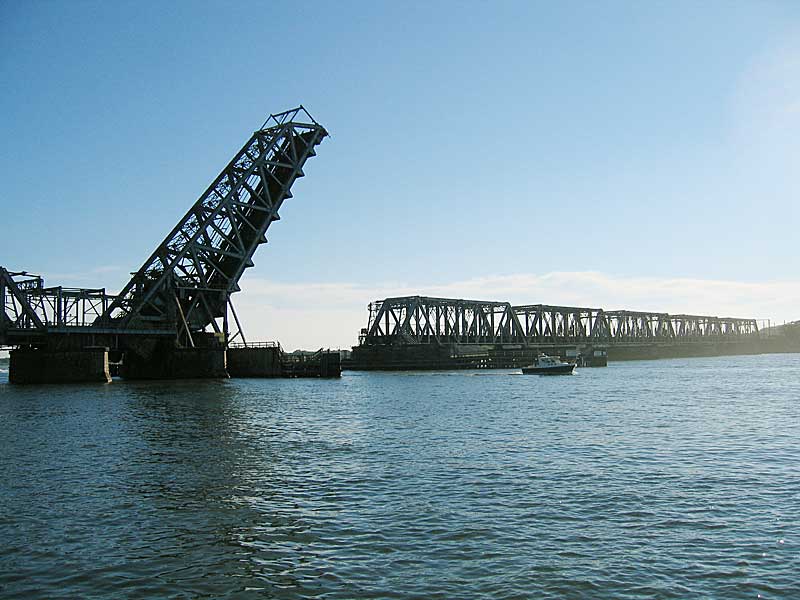
Three of these bridges (Figs. 16, 17, and 18) cross the Connecticut, Niantic, and Mystic rivers, respectively.
Of particular interest is the fourth crossing (Fig. 19) of the Thames River.
 |
| Figure 19. Thames crossing alignments |
_101.JPG/800px-Thames_River_Bridge_(Connecticut)_101.JPG) |
| Figure 20. Thames Bridge |
This is because of two reasons: (a) the Long Bypass and Along the Shore at at their closest here, and (b) the old bridge (Fig. 20) can be replaced with a high-span fixed link that accommodates both expresses (utilizing the Long Bypass) and regionals (utilizing Along the Shore). Space is available for bridge spirals, thereby reducing the amount of times the old bridge--now utilized by freight--needs to be opened.
 |
| Figure 21. Rhode Island easement concern? |
A final note (Fig. 21) pertains to a couple of moderate curves in rural Rhode Island, north of Charlestown. While replacement is not necessarily a priority, takings are inexpensive here, and a straighter easement (such as along my tangent line) could be developed.
Past this point, the line has excellent track geometry--the Acela hits its full speed here--north to Providence. Providence has some curvature issues of its own, but we'll talk more about those later.
___________________
*Which would also replace current Port Interlocking in functionality, incidentally.