Showing posts with label Baltwash. Show all posts

Friday, September 26, 2014

The Streetcar Fiasco

Streetcars have become a major fad over the past few years, ever since Portland put in theirs.
Portland Streetcar
In Portland's case, the streetcar is a pretty decent investment: it acts as a circulator overlay on a high-quality light rail system. But after they put theirs in a bunch of other cities began to construct streetcars for themselves.
H Street Line, Washington, DC
DC's H Street line was the second major streetcar; it is also the first that suggested an underlying problem. You see, H Street is supposed to be a spine corridor, linking the city's east side with its west. It thus needs to be built to a higher standard capacity than ... that.
This particular design -- at the time, novel* -- contains two catastrophic mistakes that permanently mar this line's capacity:
  1. The line has been built in a mixed traffic lane rather than be given its own dedicated lane. This reduces the streetcar's speed and makes it no better than a bigger bus on rails. Part of what makes light rail successful** is the dedicated lane. Without this lane the line is unable to bypass car congestion and thus provide the positive time differential that helped justify e.g. Salt Lake's investment.
  2. The line has been built in the outer lane. This second point makes it own strange kind of sense -- once you've decided not to build a dedicated ROW, there's something vaguely suicidal about asking passengers to run across a traffic lane unless you're willing to put carstops in, and if you're doing curb bumpouts as well, then why not put those there? However -- by putting the streetcar track in the outer lane you create conflicts between the streetcar and parallel parkers, delaying the transit vehicle for a single driver. These kinds of conflicts slow down vehicles on our country's remaining historic streetcar lines all the time -- one of the reasons Boston's Green Line is one of the most reliable is because (unlike the examples in Philly, Toronto, and San Francisco) the vast majority of the surface system lies in dedicated medians.
H Street was a difficult design challenge. The street is, surprisingly, 90 feet wide, and it is fairly congested -- its AADT hovers a little above the max capacity of a two-lane street -- and a full light-rail buildout would have likely required (among other things) taking of a parking lane significant street reconfiguration, much like 1st Street in San José, a bright spot in the VTA system.
1st Street, San José
Indeed, it is arguable that the H Street Line's optimal placement would have been for the light rail to lie between the sidewalk and the parking lanes, with a road diet reducing auto capacity just enough to convince (some) drivers to Take Other Routes. This arrangement, however, remains problematic in its own right, and is not the thrust of this post -- and I have talked about these kinds of things before.
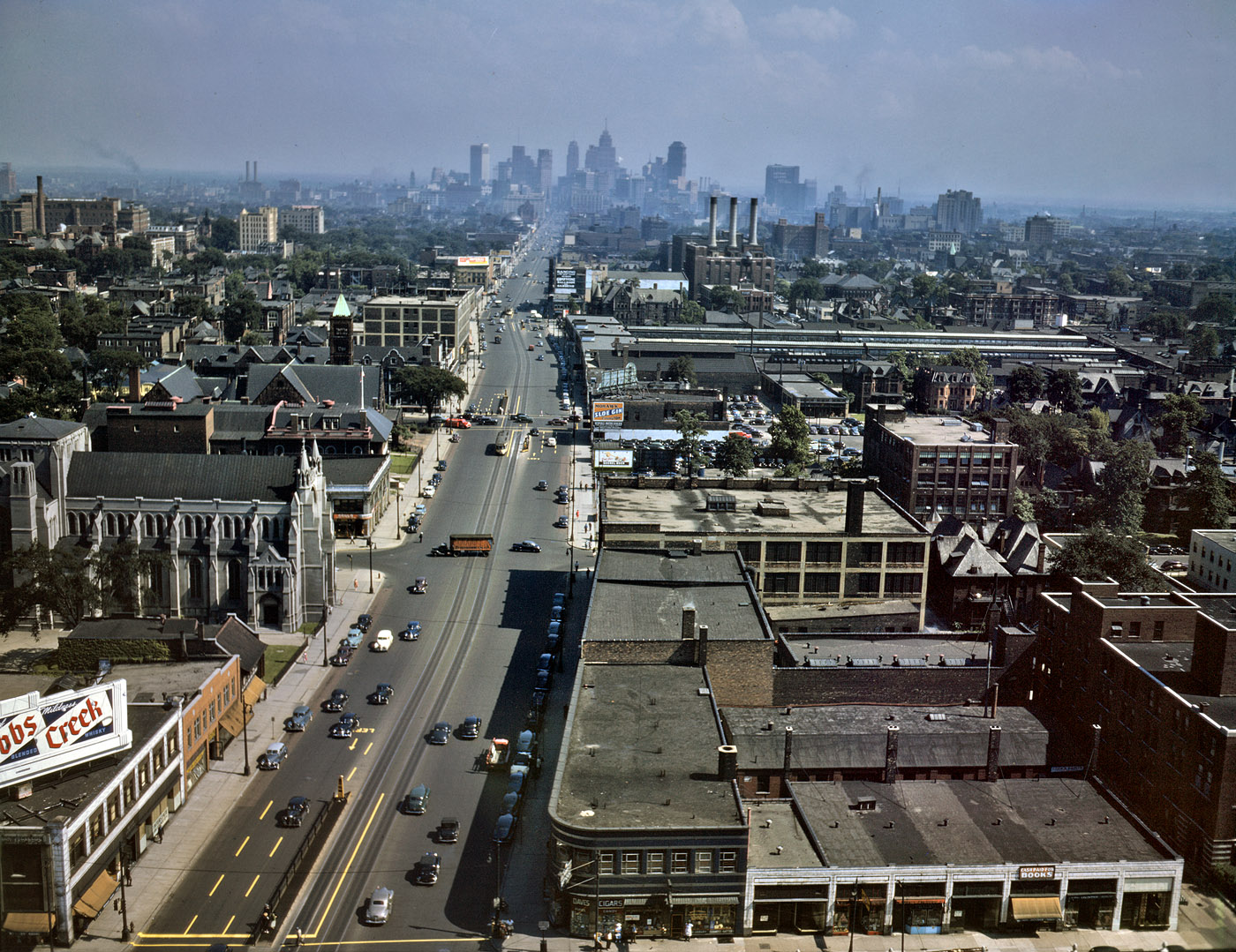
Woodward Avenue, ca. 1942. Note that even then there was little real congestion.
M-1 Streetcar plan reveals same engineering failures as H Street -- this time, with even less excuse.
At least two Midwestern cities have taken the (failed) H Street approach and applied it to themselves: Detroit and Kansas City. I haven't been to Detroit, but I will note that Woodward Avenue, which is eye-poppingly wide relative to traffic, can easily accommodate every single mode, if the designers chose to.
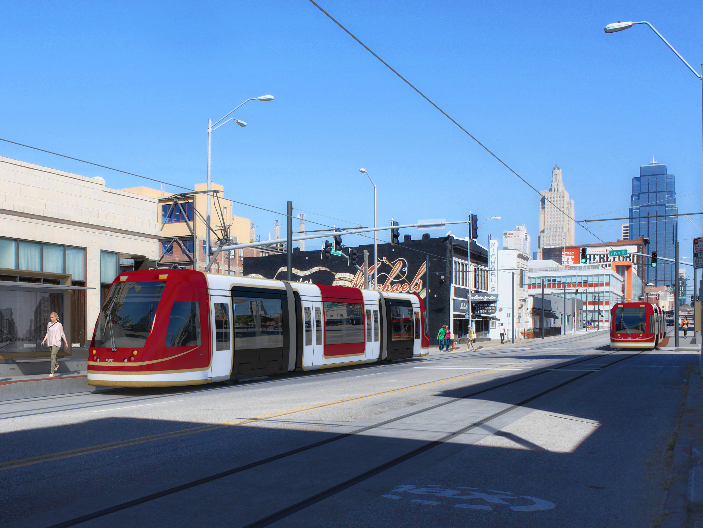
Kansas City Streetcar render
What is perhaps most shameful is that within these ... things ... lies the fact that the powers-that-be continue to refuse to give up any street space for cars, no matter how ridiculous the car gluttony may be *cough cough Detroit, Kansas City cough cough*, and are packaging it as a political sop to Millennials.

No. The transportation investment that would please us the most is in quality bike infrastructure. We want to ride around everywhere. Bike-friendly cities are Millennials' cities.
____________
* Portland's downtown streets are only 40 feet wide; historic streetcars ran in the middle of the street. (See, for example, Philly's trolleys.)
** And good BRT -- Cleveland's Euclid Avenue being the only such example in the United States today.

Wednesday, August 3, 2011

Improving Transit in Baltimore

Some time ago I started a 3 (now 3.5) part series on improving transit in Maryland and D.C. The first part designed improvements to the Washington Metro via targeted extensions to underserved areas--especially jobs centers--and a more complex downtown D.C. network with more routes and increased interlining. Also recommended was the installation of an express track between Rosslyn and East Falls Church (the extent, that is, the Orange and Silver Lines are interlined outside of Central Washington). The second targeted improvements to MARC, firstly by merging it with VRE, and secondly, by greatly increasing commuter rail services around Baltimore. The second-and-a-half took this a little further, discussing natural extensions of the core network proposed and the technical issues inherent in creating an S-Bahn-like network through downtown Baltimore. This third post discusses improvements that can be made in Baltimore.

...Except my work's already done for me. More or less.

What the MTA has proposed is a wide-ranging light rail network that builds on the two existing mass transit lines in Baltimore (the Central Light Rail Line, marked blue, and the Baltimore Metro, marked green, on the map). Even though this proposal dates back to 2002 now, and has not seen much in the way of new work, the plan, the principles behind the plan, and the plan of implementation are all sound. When I argue for more long-range mass transit planning, this is exactly the kind of thing I'm arguing for. The Washington Metro wasn't built in a day; in fact, it took roughly 30-40 years from the start of the planning process to the completion of the first-generation network. The first-generation Baltimore network would take on the same look, but done with more light rail and less heavy rail. See below.
Of course, there are still issues and longstanding mistakes. Extending LRT towards Columbia is nowhere near as effective as extending commuter rail (i.e. a variant on the Orange Line); similarly, the Blue/Yellow Line towards Hunt Valley, following ex-Northern Central Rwy. rights-of-way is nowhere near as effective as an alignment towards Towson, following ex-Maryland and Pennsylvania right-of-way (assuming it still exists) would be--although the northern Yellow Line proposal (along Charles Street) would go quite a long way in rectifying that. And the Red Line proposal that has the most traction has piss-poor interconnection with the existing lines (not so much a network as a motley connection of lines).

Even so--a strong long-range framework for local transit exists, or seems to, in Baltimore--much stronger than what you would find in e.g. Philadelphia. Which, again, is the point of this blog.

In the long run, I would encourage Maryland to consider the MTA and MARC as layered networks in a wider system, and quit trying to (like Dallas) overextend its light rail network.

Tuesday, August 2, 2011

MARC, Revisited

A little while ago I wrote a post describing my ideas for improving Maryland commuter rail service. They included:
  1. Combining MARC and VRE to create an S-Bahn environment in D.C. via the First Street Tunnel;
  2. Extending new MARC lines from Baltimore to Annapolis, Frederick, Gettysburg/York, and Westminster (mislabled "Westchester" on the map...bugger); and
  3. Creating a linkage between Camden and Penn Stations to provide an S-Bahn routing through Baltimore, along with
  4. Electrification of all routes (drrr...).
First of all, I'm going to return to the downtown Baltimore tunnel. After spending some time researching the history, I realized it's easier than originally thought: the Howard Street tunnel already does my job for me. This plan thus assumes the reuse of the Port Royal station shed as a new passenger station with an easy pedestrian link to Penn Station (about three blocks away).

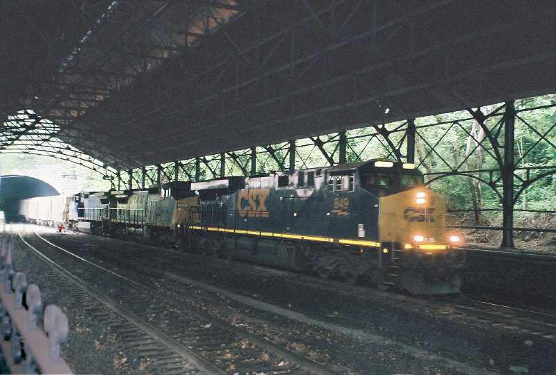
However, the Howard Street Tunnel is currently a CSX main line--the one I like to call the "Royal Blue Line" after the B&O name train that once ran it. Combining the operational density of this New York (and beyond)-Washington (and beyond) freight main with two passenger routes at hourly frequency off-peak, 15 minutes peak, is a cocktail for disaster. Hence, in order to use this tunnel, through freights must be shifted off this line.
Current conditions: Mt. Royal station, Howard St. Tunnel.
The question is, how? There does not seem to be any good freight bypass of either Pennsylvania or B&O heritage around central Baltimore, the way there is (for example) a high line freight bypass around Philadelphia's 30th Street Station, and furthermore, both major mainlines through central Baltimore follow shallow tunnels, rendering both unfit for double-stacks; this situation implies that fast freight must follow a significant bypass--the most obvious route heading straight north, via the route being proposed for the Pennsylvania Line trunk, and tying into the former Alphabet Route mainline at Hanover Junction (where the branches to Gettysburg and York also split) towards New York and Philadelphia via Reading...but this routing is, on the face of it, baldly insufficient, especially for CSX, which must run its fastest freights a full day's travel along trackage rights to overcome the insufficiencies of the main line. A hazmat fire in 2001 crystallized the need to vastly improve the facilities at hand, but no option is cheap. Even so, the fact that no freight route through Baltimore currently allows for the transshipment of the tallest equipment the U.S. freight network uses absolutely must be rectified--both to improve the nation's freight network and to free up the Howard Street Tunnel for passenger rail use.

That said, another issue arises. With the Howard Street Tunnel vacated by CSX, MARC can extend the Camden Line (and indeed, all possible lines entering Baltimore from the south via ex-B&O ROW) north to Mount Royal--which offers a close connection to Penn Station--but new lines coming from the north, following the former Western Maryland main to (a) Westminster, (b) Gettysburg, and (c) York would naturally terminate at Penn Station (as Penn Station was once the Western Maryland's Baltimore terminus); changing the access to one that enters Mt. Royal would either need (a) new portals on the Great Circle proposal, or (b) a cutoff from the ex-WM main to the ex-Northern Central main (now the ROW of the Blue Line light rail) somewhere between I-695 (an optimal locale for a park-and-ride) and Druid Hill Park--preferably one at or near the closest (and therefore cheapest) point between the two--or, if possible, following an old ROW connecting them together (such as the one indicated on the map below between Garrison and Lake...Roberts(?); this line appears, from Google Maps, to be (mostly) unmolested.
The former Northern Central Rwy. branch offers, at its nether end, a spur with good curvature to take up the two new lines running northward from Mt. Royal, which is rather useful since the larger-scale projects to alleviate freight and passenger congestion through P&B and Howard Street tunnels will almost certainly form an infrastructural maze in the Jones Falls valley just north of North Avenue. By establishing a close parallel with the light rail infrastructure, the new line is able to traverse this maze using one of the existing ROWs for guidance.

Now my discussion turns towards Virginia. In my original post on the subject, I mentioned merging MARC and VRE--a merger of administration, operations, and equipment. This merger also implies that the combined new agency (which I am provisionally calling MARC) would take over any useful expansions into Virginia. Two exist, both from Manassas junction: one towards Charlottesburg, and the other, Front Royal; VRE is already studying an extension towards Gaither and Haymarket along the latter. Provisionally, I have added both as a pastel-shaded possible extensions of the Manassas Line.


Another possible extension is conceivable along the former Western Maryland main line from Westminster to Hagerstown, and finally, a suggested extension is shown from D.C. (L'Enfant) down to Waldorf and La Plata, communities with tough car commutes. Initially, I had discounted this line because the most obvious running is to Bowie, but I have it on good authority that the former right-of-way from Brandywine Jct. towards Anacostia has been preserved; if true, then this route would be amenable to either commuter rail into the urban core (via Greater Landover) or an interurban extension of the D.C. streetcar.


Following these new ideas, as well as the possibility of a second Annapolis line via the former line from Annapolis Junction, I've made a couple of new provisional maps of this D.C. commuter rail network, showing how these expansions extend the reach of commuter rail to the nation's capitol. The Google Map is linked to; below see the map based on the broader MARC map.

Tuesday, July 5, 2011

Improving MARC

This is the second in a three-part series on improving transit in the southern part of the Northeast. The first focused on the Washington Metro, and the third will focus on mass transit in Baltimore.

MARC is Maryland's commuter rail system. It certainly does its job, with three lines emanating from Union Station, and three lines emanating from downtown Baltimore. The Penn Line runs from Perryville via Baltimore Penn Station to Union Station; the Camden Line from Camden Station in downtown Baltimore to Union Station; and the Brunswick Line from Martinsburg, WV, to Union Station. Along with the two VRE lines from Union Station to (a) Fredericksburg and (b) Manassas, MARC offers adequate commuter rail for the D.C. area. In concert with the Metro, this means the D.C. metropolitan area has the third-best transit infrastructure in the Northeast, and fourth-best in the nation, after New York, Chicago, and Boston.
MARC, current conditions. Wikipedia.
MARC could, however, be better. Its charter doesn't just call for D.C.-area commuter rail, it calls for commuter rail for all of Maryland. Its Baltimore lines are relatively poor, concentrating along the Royal Blue/Northeast Corridor axes rather than branching out throughout the metropolitan area, and it lacks service to either Maryland's state capital, Annapolis, or its sixth largest city, Hagerstown, despite reaching all the way to Martinsburg. MARC's paucity of lines, relative to potential (VRE has two lines, but all of the historic lines heading from D.C. into Virginia are accounted for between it and the Metro's Orange Line) makes it the Northeast's worst commuter rail system in terms of service scope.
VRE system map. VRE.org.
My improvements to MARC go well beyond just extending the Penn Line to Wilmington to interconnect with SEPTA. To offer excellent rail transit options at a commuter and low-level intercity capacity, the proposal is to merge MARC and VRE and to transform the system into a double-S-Bahn-type network, with an S-Bahn set emanating from Baltimore and a second from D.C. The current MARC network, when combined with VRE, produces a three-line double-S-Bahn network (Penn Line, Cumberland-Fredericksburg Line, Camden-Manassas Line), but only one of these three lines has a Baltimore nexus.
Line additions thus concentrate on Baltimore. Two new lines are proposed, extending from Gettysburg, PA via Baltimore to Frederick, with a branch to York, PA, and one from Westminster to Annapolis. Additionally, a branch of the Cumberland Line from Duffields (WV) to Hagerstown (MD) is proposed.
The plan of action for this new system would be to activate the lines into the city center first. These would take the form of two new lines terminating at Camden Station (one to Annapolis, and the other Frederick), and two at Penn Station (one to Westminster, and the other Gettysburg/York), constituting Phase II. Finally, once the lines are all in use, the interconnection between Camden Station and Penn Station will be built, linking the two sections of the Gettysburg-Frederick and Westminster-Annapolis lines together.
The line names are interesting. After thinking about it a bit, I decided to go with a 3-letter initialism, such that each line has the north origination first, the via city second, and the southern terminus last. Thus the Penn Line becomes WBW, or Wilmington via Baltimore to Washington, and the Cumberland-Fredericksburg Line becomes MWF, or Morgantown via Washington to Fredericksburg. This system is elegant and seems easy to apply to other networks, too.
MARC, improved. Five lines offer service throughout the Baltimore and Washington metropolitan areas.
A couple of interesting features are present in this system. First, because Martinsburg and Hagerstown are opposite poles of a micropolitan area, a shuttle train between the two would be immediately suggested; this shuttle, due to the nature of the system just outlined, would have a fare union with the broader network. Secondly, this network passes several Civil War sites (both Bull Runs, Fredericksburg, Gettysburg, Antietam), which effectively makes this system a Civil War railroad and thus able to provide excursions for reenactors, history buffs, school trips, Scouting trips, etc. Excursions, by their nature, are not scheduled trips; however, the equipment needed to run this system normally makes providing them a worthwhile promotion--a good loss-leader, if you will. And finally, this network suggests further extensions, including one to Harrisburg, another from Westminster to Hagerstown, and a third from Martinsburg to Cumberland.

MARC is an average system, by American standards. Let's make it better.

Saturday, June 25, 2011

Washington Metro, Improved

This is the first post of a three-post series (maybe) on improving transportation in Maryland, D.C., and northern Virginia. In the first post, I concentrate on the D.C. Metro. In the second post, I will talk about commuter rail in Maryland and northern Virginia (MARC and VRE), and the third, improvements to the Baltimore metro.

The D.C. Metro is among the most convenient subway networks in the U.S., being about equally as convenient as, say, Boston's or Chicago's (though nowhere near as convenient as New York's). However, it has two conflicting mandates: at its nether reaches, it acts as a commuter rail line, and in the city, a traditional subway. This would work a lot like New York's Far Rockaway or Jamaica Bay subways...if there were express tunnels. Instead, since the tunnels are all two-track and there doesn't seem to be a way for overtaking to be scheduled in, all trains are effectively local trains. This works well on lines, in theory, where there are connections with MARC or VRE, since it enables local/express passenger transfer--that is, passengers originating on the Metro but wishing to skip intermediate stations and go straight downtown can use the commuter rail going to Union Station from places like Alexandria, Silver Spring, or New Carrollton, or passengers originating at Manassas and going to Bethesda, or Gaithersburg going to Rosslyn. However, since the ticketing networks of MARC, VRE, and the Metro are mutually exclusive, this is made prohibitively difficult for most passengers. Therefore, the first major action needed is to unify the ticketing schemes and operational patterns across the three networks, in a way that mirrors European S-Bahns. This is, of course, organizational improvement.

Even so, there are real concrete improvements that do need to be made. The network offers poor access (service gaps) into parts of the metropolitan area to the north, south, east, and west of downtown--most pronounced all along the Potomac, in east D.C.'s poorer neighborhoods, and directly west of the Pentagon. Additionally, as the core of the system was designed with the 1970s downtown in mind, it offers an increasingly inadequate service. (See Exhibit A.)
Exhibit A. Note how current system, while adequate by American standards, has major gaps in several directions, and downtown service can be improved.
Greater Greater Washington recently ran a series on second-generation improvements to the Metro, and while some of the ideas were pretty good (such as running the Yellow Line out to Union Station via 2nd), others were merely okay (the north-running Blue Line idea and its Silver Line kin: same idea, different lines), while others were just atrocious (the how far outside D.C. would the Brown Line be extended, anyway?
Exhibit B. The new network idea.
Taking the best three ideas--the Yellow Line tunnel out to Union Station, the southerly separate Blue Line tunnel, and a modified version of the Green Line spur to National Harbor, I came up with Exhibit B. This Metro system sports two new lines (Brown and Pink), and, to complement the new tunnels, extensive new interlining. This interlining would, in addition, offer superior Generation II downtown service. A final addition is the construction of an express track along the interlined Silver/Green section between Falls Church East and Rosslyn; this track would allow for faster commutes along what is now the single longest interlined section in the network (see Exhibit C).
Exhibit C. Downtown lines and interlining.
These lines would be as follows:
Red Line would be unchanged.
Orange Line would be unchanged.
Green Line would be unchanged.
Blue Line would run a new downtown tunnel from the Anacostia River, via H Street, to Union Station, where it would curve down to the National Mall, servicing the primary jobs and cultural centers in the city. It would then curve up through Foggy Bottom to Georgetown and return to the current Blue Line at Rosslyn.
Yellow Line would (1) be extended south from Huntingdon to Beacon Mall, (2) run a new tunnel via I and 2nd Sts. to Union Station, and (3) follow a new alignment north along North Capitol Avenue to Rhode Island Avenue and thence 18th St. NE out to Langdon and Howard Divinity School.
Silver Line would be extended along a new route along North Carolina Avenue, Tennessee Avenue, and the Bladensburg Road to Bladensburg and thence across the Anacostia out to Riverdale, where it would terminate in a new transfer stop with the MARC Camden Line.
Purple Line light rail would be unchanged. (It's a Maryland project, anyhow.)
Brown Line would run from Carderock, MD, via Langley, VA, and American University through Georgetown and thence interline along the Yellow and Green Lines into Anacostia, where it would peel off and continue running south to Forest Heights and National Harbor.
Pink Line would run from Walter Rand Medical Center in northern D.C. down through Columbia Heights, where it would interline with the Green Line to L'Enfant Plaza, and then interline with the Yellow Line to Pentagon, where it would follow a westerly route into Virginia via Columbia Pike to Bailey's Crossroads and Annandale.

This network would implement service to the D.C. area's major service gaps and greatly improve downtown circulation (especially around the Mall). Combined with fare and schedule unions with MARC and VRE, making cross-platform connections infinitely easier, this network would offer the D.C. area an impressive Generation II metro/commuter rail network.