Showing posts with label New Jersey. Show all posts

Thursday, June 11, 2015

South Newport: Or, A Case Study On Why "Open Space" Is Bad

So I stumbled across this post the other day. In it, the poster argues that, while the northern half of Jersey City's Newport district seems to have made an attempt at Vancouver-style urbanism, it does not succeed to the degree Vancouver's does.
Newport, Jersey City. It's telling this -- not a streetscape -- is the beauty shot.
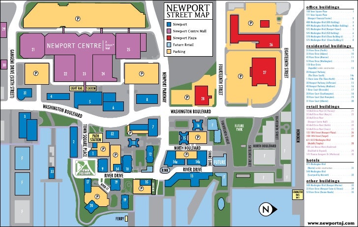
This is not an unfair claim. Having been in Newport a couple of weeks ago (because Reasons), I can confirm with my own eyes that, while the River Drive is a reasonable urbanism, and the corner of Washington Boulevard and Town Square place has -- even when it decides to rain -- more than enough people to overcome its inferior site design, the southeast corner of Newport is a weird corner of buildings spaced too far apart: a sense of enclosure is lacking, and the buildings don't really capture as much commercial energy as they ought to (despite the existence of excellent sushi and boba tea joints).
Abandoned Pavonia Terminal from sometime in the '70s
In large part, this is because Newport's first phase dates to the late '80s: up to about 1960, the site was home to the Erie Railroad's Pavonia Terminal, a handsome Victorian edifice. Photos from the '70s show the passenger terminal as having fallen into ruin (though it is unclear whether the Erie's successor, the Erie-Lackawanna, had freight facilities in the area). By the early '80s, the bankrupt E-L was absorbed into Conrail, along with a whole bunch of other railroads; it focused its freight landport at the old Lehigh Valley (another bankrupt railroad)'s Oak Island Yard in Newark's Ironbound.* The complete abandonment of  the E-L's waterfront facilities soon followed.

The developer promptly razed the site flat (including the old terminal building)** and built a shopping mall and office park in its stead. As site development -- still incomplete -- continued, modern retail has been built west of Washington Ave. (in particular, a large power center north of Newport Parkway), and more recent residential shows the effects of radical change in urban theory.***
Building mass models of north and south Newport
The Urban Prospector shows a Sketchup mockup of both the southern and northern parts of Newport, focusing on the long streetscape gaps to the south. Those gaps are the ultimate end-result of the planning of the day, which favored generous "open space": the Modernist tower-in-a-park paradigm. While towers-in-parks and commercial aren't necessarily antithetical to each other, it is notable that in examples where commercial has successfully been integrated into towers-in-parks, such as Metropolitan Ave. in Parkchester, the Bronx,^ it is built to the street, taking over the green space.

That's because the eye is caught by proximate activity. When this activity is not well displayed, or is broken up by excessive greenswards (which also serve to decant park use, thereby making each greensward less interesting) -- both of which are the case in south Newport -- the street becomes significantly less pleasant. The more green "open space" a site has, the worse it's framed, the less concentrated its use, the less urban the neighborhood. Despite the river walk -- a key amenity -- this is clearly seen in south Newport.

Fortunately, it's easy to calculate open space -- it's how much of the site isn't, in fact, built on. That is, it's the opposite of a site's building coverage.
North and south Newport
For this exercise, I decided to consider "North Newport" the developed part of River Drive north of Newport Parkway. (The southwest corner of Newport Drive and 14th Street is clearly a parcel that hasn't been developed yet, not a public or semipublic green space; the same holds true for the piers.) South Newport is considered the part of Newport that extends from Newport Parkway down to Thomas Gangemi Drive east of Washington Boulevard. I was also interested in how much of the open space is given over to car use (storage, mostly). Finally, I disregarded the street, considering it public right-of-way. Here is the map yielding the polygons I used.

So, for north Newport, we find that:

  • 3.83 acres are covered by buildings
  • 1.46 acres are green space
  • 0.00 acres are "car" space
This means that there are a total of 5.29 developed acres in North Newport, of which a mere 27.6% is "open space", arranged as part of the riverside park and a small plaza.

For south Newport, by contrast:

  • 12.48 acres are covered by buildings
  • 10.32 acres are green space
  • 3.48 acres are "car" space
Summing this up, we see that there are 26.28 total acres in south Newport, of which 13.8 acres are "open space", some 52.5% of the site. A surprisingly low 33.7% of the "open space" is actually devoted to cars: its high visibility has urban fabric-destroying impact, however.
Actually, the site plan shows even more open space, perhaps as much as 60%
But what about the undeveloped parcels? There are three undeveloped sites around Newport Green Park, totaling 13.06 acres. Assuming they are developed to the same density as north Newport^^, that yields 3.60 acres of open space, or 9.6 acres covered by buildings^^^.

If we consider "greater north Newport" to be the sum of developed north Newport + undeveloped north Newport + Newport Green Park (4.93 ac), that yields 24.02 acres. According to our methodology, 9.99 acres of that will be open, or 49.6% of the site. This compares favorably with south Newport's 52.5%.
Can this be replicated elsewhere in Newport?
Yet because of choices in how the "open space" is placed, north Newport's 49.6% will be far more effective, and far more heavily used, than south Newport's 52.5%.

That's because north Newport's open space won't be decanted into small enclosure-destroying plazas and port-cocheres the way south Newport's were. Instead, it'll be concentrated into one well-sized neighborhood park, a place that's already well-loved, despite the fact that but a single development abuts it.

_________
* It is notable that the Erie-Lackawanna's other predecessor railroad, the Delaware, Lackawanna & Western, had built what was perhaps the best non-Pennsylvania Railroad freight route from New York west. But when I-80 was built through Paterson, the State bought part of the E-L's low-grade mainline; freight movements on the replacement route, a commuter branch now part of the New Jersey Transit's Montclair-Boonton Line, proved less than ideal (and is, in fact, cited as a contributing factor as to why the E-L failed to outcompete its collapsing competition). Had the E-L retained the track connection through Paterson, it is likely that Conrail would have favored that -- shorter -- mainline to Buffalo, which in its turn would have favored more intensive passenger use of the Water Level Route -- today's Empire Corridor.

** Which should have been preserved and renovated IMO.

*** Or possibly just the success of Battery Park City (built by the same developer). Though, that said, Battery Park City has perhaps the blandest streetscape of any Manhattan neighborhood.

^ Incidentally, fully planned as early as 1939, which helps explain the unusual insertion of a Main Street when similar postwar projects (cf. Lafayette Park, Co-op City) favored small strip malls.

^^ Which may or may not be likely.

^^^ But what about streets? There has to be automobile access, especially on the huge northernmost parcel!

Wednesday, June 10, 2015

What does $777.3 million buy you?

According to the Business Journal, American Water is getting a $164 million tax break to move to Camden.

This is on top of this short list of other companies who have been bribed into moving into Camden:

Here are a few other companies that have moved to Camden as part of a 2013 state law that increased incentives for employers who moved to Camden:
• Volunteers of America Delaware Valley(VOADV) was approved for $6.3 millionto consolidate administrative offices into one facility in Camden rather than a location in Bensalem, Pa.
• Subaru of America netted $118 million in tax breaks to move its U.S. headquarters from Cherry Hill to Camden.
• Cooper Health System received $40 million to move about 350 administrative jobs now located in Cherry Hill and Mount Laurel back to its main campus in Camden.
• The Philadelphia 76ers obtained $82 million in tax breaks to build a practice facility and corporate headquarters.
• Holtec International received $260 million in tax breaks to build a manufacturing facility.
• Lockheed Martin was provided with $107 million in assistance to relocate employees from Moorestown to Camden.
All told, this is about $777.3 million, more than three-quarters of a billion dollars to get companies to locate in Camden.

While Camden is a challenged market in all sorts of ways, and it is likely significant public subsidy is needed to jump start it, this isn't how to do it. This is just sheer economic poaching -- shuffling jobs around without actually creating new jobs. What impact to the region's economy is there if VOADV is in Bensalem instead of Camden? The Sixers in Philadelphia instead of Camden? Lockheed Martin in Morrestown instead of Camden? The article says:
If American Water leaves its Voorhees, N.J. headquarters for Pennsylvania, then New Jersey will lose about 600 jobs on top of hundreds of potential new jobs that would go into constructing American Water's new campus.
If American Water was to move their corporate HQ to Pennsylvania, would they move it to Moon Township? Of course not: that would involve uprooting ensconced executives. It would stay in the Philadelphia area (winding up, most likely, in Bensalem).

The economic impact of this strategy is nil. There is no net change in regional economic productivity. There are no new jobs, no new work. All this does is marginally change commuting patterns. And while it's nice that the new Camden jobs would be close to PATCO, is this marginal access improvement really worth $777.3 million in public money? Instead of subsidizing existing jobs, wouldn't that $777.3 million be better spent elsewhere?

If the goal really were to make more jobs instead of simply bribing companies to go where you want them to, wouldn't a far more effective program be a small business incubator in Camden?

Wednesday, May 27, 2015

Quick Note On PATH

Found this AP wire today: http://www.philly.com/philly/business/transportation/304536631.html

Mayor Zimmer is right not to be happy, and to be suspicious of PATH's stated motives. Decreasing the frequency from six minutes to seven does indeed decrease the line's throughput and capacity -- by almost 15%, in fact, assuming all else remains the same (same consists, etc.) Given the fact that the trains are already congested, this move will only further increase congestion within New York's largely transit-dependent commute market.

In other words, this move will not increase capacity. In fact, it will only make the capacity problem worse. The rank hypocrisy in the press release is appalling.

There are good reasons for reducing the frequency. The rolling stock might need to be rebuilt; this reduces the trains on hand and so requires frequency reduction. Perhaps the tunnel needs some work. (Though that can be done off-peak.) But to judge whether the plan has merit, PATH needs to be transparent.

And in lying, it proves it is not.

Thursday, February 16, 2012

New York & Greenwood Lake

I am starting a rail asset stock for North Jersey, and in  the course of my research discovered the current NJ Transit network is only about 2/3 of the area's potential commuter rail network.

An excellent example of this is the New York & Greenwood Lake line, built as in independent railroad linking New York City with a remnant glacial tarn in the Catskills. Eventually acquired by the Erie Railroad, it was an active commuter line until 1982, and part of it has been repurposed into the Montclair-Boonton Line. But part of the ROW is lost--at the bottom of a reservoir, in fact.

This is an excellent example of viable disused passenger rail in North Jersey.

Wednesday, February 15, 2012

South Jersey Regional Rail

This is Part III of a very long-term commuter rail plan. Part I dealt with Pennsylvania rail assets, with Part Ia as an addendum; Part II dealt with South Jersey rail assets.
Proposed South Jersey rail network
Despite having plenty of infrastructure in place, South Jersey currently has no substantive rail network. Only three lines serve this area, and they, for the most part, avoid the core neighborhoods.

It should say something that, while the Pennsylvania-Reading Seashore Lines once had a large, complete South Jersey passenger rail network, only one--the former Main Line from Camden to Atlantic City--is still in use, and even then, split between heavy rail PATCO and commuter rail Atlantic City Line. Disuse of this infrastructure represents a waste--but a waste no different than the waste engendered by the disuse of viable commuter rail infrastructure in many other American cities (e.g. Pittsburgh, Detroit, Cleveland, etc.) Elsewhere, particularly in the Mountain West, work is being done to rectify this; however, there are still many places where even the idea of a passenger train is anathema.

Let us turn back, though, to a prospective South Jersey network. After surveying the rail assets, we can determine that there are two distinct networks that dominate South Jersey:

1. A commuter network largely running down the Millville Branch spine, and
2. An intercity network linking to the Shore destinations.

Both networks historically converged on Camden's massive Federal Street terminal, which had ferry connections to the Philadelphia waterfront. A station also existed at Broadway, which was the terminus of the Delaware River bridge subway. From there the routes fanned out: to Trenton, to Amboy, to Toms River, two to Atlantic City (both converged at Winslow Jct.), to Ocean City and Wildwood and Cape May, to Grenloch, to Vineland and Millville, to Bridgeton, to Salem, and to Pennsgrove. However, while it is reasonable to converge the commuter lines on Camden, it is preferable to converge the intercity network on 30th St. Station.

Six lines are viable commuter lines, four intercity, and two possible Atlantic City commuter lines. Two more lines are viable North Jersey lines which meet this network--for the time being, we'll assume these lines terminate at Newark, but we'll also want to look at bringing them to Hoboken, or better yet (if we as a nation finally decide to get our rear in gear and aggressively finance urban rail improvements) directly into Manhattan, perhaps via Staten Island. But that's for later.

The four intercity lines run to Ocean Grove via Toms River, where it connects with a former CNJ ROW that would be viable for a passenger restart, and Pemberton, where it meets the commuter network; to Atlantic City via Winslow Jct., where it meets the Cape May line and the commuter network; and to Ocean City, which meets the Cape May line at Tuckahoe. A dinky would also service Wildwood from Wildwood Jct. on the Cape May line.

All four lines would cross the Delair Bridge over the Delaware; only a single-track lift bridge, this presents probable capacity issues--even at hourly service, this represents a crossing roughly every 7.5 minutes (60/4=15, and you have to factor in that it's hourly service each direction, so 15/2). When the bridge needs to be raised (as it occasionally does), this will throw service times off--however, that is a compromise worth living with for direct Philadelphia service.

Two small natural lines extend out from Atlantic City. Both can be serviced with light rail. These two lines lead to Mays Landing and Somers Point, respectively; the Somers Point line runs through a densely built-up area while the Mays Landing line accesses Shore destinations such as the Shore Mall and the Atlantic City Institute of Technology (abbreviated ACIT).

The core network converges on Camden; there, passengers can transfer to PATCO (a fare union would be most advisable) or debark for local destinations. We will talk about the opportunities and pitfalls Camden offers soon. Tops on the agenda: figuring out how to bring a commuter rail throat into a city that willfully destroyed theirs during the '60s.

The six lines reach Camden from: Trenton, New Egypt (Ft. Dix), Hammonton (via Clementon), Millville and Bridgeton (via Vineland and Glassboro), Salem, and Carneys Point (Pennsgrove). Let us tackle each of these in turn.

The Trenton line is, more or less, NJ Transit's current River Line--the way it's set up is as FRA-noncompliant "light rail" that runs along trolley tracks through downtown Camden. The equipment the River Line uses, however, is a type of Stadler DMU related to the Flirt, which, if you recall, is one of the pieces of rail equipment that must be made legal in any sane rail regulation regime. If the FRA regulations went away tomorrow, it would be the favored type of equipment throughout the South Jersey network.

There are two components to this line: the downtown Camden light rail line, and the commuter line, shared with a freight line, along the former Camden & Amboy main line as far as Bordentown, and its branch to Trenton thence.

In order to build a true commuter network, the Camden light rail line has to be repurposed. (I will talk more about what this entails later.) So we'll concentrate on the former C&A line.

This line connects with SEPTA's existing R7 Trenton Line and NJT's existing Northeast Corridor Line at (unsurprisingly) Trenton. Abandonment Repurposing of the River Line's existing Trenton terminus and termination on Penn Station's platforms--thereby allowing for cross-platform transfers--would be superior; the River Line's existing terminus is an artifact of the FRA's insanity more than anything else.

A secondary terminus would lie in Burlington. Coincidentally, this would be the natural terminus of any commuter rail operation running down the former C&A main line from Amboy to Bordentown via Hightstown and Henrietta. This idea has been marked as the Amboy Line on the above map, but will have to be considered in more detail whenever I get around to devising a commuter rail strategy for New York.

The Trenton and Amboy Lines, considered together, can be considered the Camden & Amboy Lines, much like the Morris & Essex Lines, for obvious reasons.

The Fort Dix line (which I affectionately think of as the Military Line) runs from Camden to the east, to Ft. Dix and a terminus in New Egypt via Maple Shade and Mt. Holly. East of Mt. Holly the right-of-way has been torn up, (but can still be rebuilt with the relocation of some local rail-trails). The Military Line itself curves north at Pemberton, whereas the intercity Atlantic Line continues to the east.

The intercity line obviously runs express past many of the stops on the local line; it definitely stops at Mt. Holly and (maybe) Maple Shade. Beyond Pemberton, it stops at a couple of smallish hamlets and crosses another proposed North Jersey line in Toms River.

This line would follow the former CNJ Southern Division main to Lakehurst and a branch thence to Tuckerton; this branch can merge into a southern approach at Amboy or into a Northeast Corridor approach in Monmouth. The Northeast Corridor approach works better for a Penn Station terminus; however, any large-scale commuter network optimization of the New York metro would likely require a far larger nest with several more tunnels--it would not be, in short, surprising for a strong southern network to make a Manhattan approach via Staten Island. (I like calling this line the Barnegat Line.)

The Clementon line follows the PRSL's former Clementon Branch, a core commuter line to Hammonton via Winslow Junction. Although it's not far to the south of PATCO, it would offer an alternative service type, and eventually, hopefully a different set of destinations.

Local trains from Atlantic City can also terminate in Hammonton.

The Millville Line is the core line of South Jersey commuter rail. Electrified once, a long time ago, this line extends from Camden to Millville via Glassboro and Vineland. Two other lines branch off in Woodbury; at Vineland the line splits into Millville and Bridgeton sections. The Millville section follows the former PRSL alignment, while the Bridgeton one follows a (mostly) CNJ one.

This Bridgeton alignment would be served by an off-peak dinky but have half the peak trains go through utilizing the connection. At peak, the dinky can be utilized to fill service gaps for both the Millville and Vineland segments.

An intermediate terminus would exist in Glassboro.

The Salem line utilizes a former PRSL alignment from Woodbury to Salem; it runs through some of the most rural areas served by the network. However, despite this rural character, it also runs through a core of small towns, like Swedesboro. Trains can run through to Salem, and Swedesboro would be a viable local terminus during rush hour.

The Pennsgrove line runs along the east side of the Delaware, from Camden nearly all the way to the Delaware Memorial Bridge (Carneys Point). As such, it accesses a series of industrial towns mirroring those across the river, like Trainer and Marcus Hook. This line can expect to see high ridership, and has been outfitted with a local terminus at Bridgeport, whose location by the Commodore Barry Bridge's New Jersey approach makes it a potential fit for a park and ride (based on the rule that such infrastructure is most appropriate where hub roads enter the core urban area--that is, the city itself--where rail lines can meet them, and where hub rail lines (commuter or regional networks) cross the middle ring beltway, approximately 15 miles from the city center; US 322 fits the latter as far as I-295).

Unlike the Ft. Dix line, the Clementon, Millville, Salem, and Pennsgrove lines all utilize existing former PRSL rights-of-way, still in freight use. In fact, the vast majority of the former PRSL network, and certainly the key lines, still exists as freight routes; what has been abandoned has generally been converted into rail-trails in populated areas (e.g. from the Turnpike south to Grenloch), and simply not built on in less-populated areas. Unlike the total loss of the former Ma & Pa right-of-way between Baltimore and Towson, a loss which has essentially screwed over commuter rail access to that region's densest suburbs, the vast majority of rail easements in New Jersey still exist, and can still be returned to passenger service.

As previously mentioned, equipment such as that currently running on the River Line would be optimal for the vast majority of the Camden network. This is standard mainline equipment in Europe, and if our rail regulations were remotely sane should be reasonably inexpensive to procure and able to run immediately, without need for pointless variances.

Over time lines can then be electrified, first to local termini and then further; once the network is bought up to a high-grade electrified network certain options look especially tantalizing...

Our next steps will be to consider what it'll take to (a) provide for a suitable Camden terminal and (b) how to best repurpose the Camden light rail route.