Note: This post supersedes Providence Alignments (PA) and part of Regional Rail from Providence, East (RRPE). Both will be referred to in the text, however.
Having developed a high-quality regional rail network focused on Providence, we find ourselves in a bit of a pickle.
Figure 1 shows what it is.
 |
| Fig. 1. Diagram of ultimate RRI operations + MBTA P.L. under current track alignments |
The problem is that, under current conditions, the
whole network is
highly unbalanced; of the four lines (plus one branch each) and the MBTA Providence Line (P.L.), fully 80% approach Providence Station from the east.
Figure 2 shows what we want instead. Specifically,
we want the Blackstone Valley Line to approach Providence from the west. That way, it can feed into the Mount Hope Bay Line (cf.
RRPE), thereby forming an X-frame S-Bahn-esque structure.
 |
| Fig. 2. Desired RRI +MBTA P.L. operations. |
To do this, however, we'll have to take a new look at central Providence.
Figure 3 shows Providence Station's current and attainable alignments, unchanged from
PA Fig. 9.
 |
| Fig. 3. PA core network (Fig. 9 there) |
But to bring the Blackstone Valley Line in from the west, we need an entirely new station approach, and that implies an entirely new station; using Union Station as our template (
Figure 4) would continue to yield an eastern--rather than western--approach for that line.
 |
| Fig. 4. Providence Union Station |
The historic alignment suggests that the least disruptive path,
Figure 5, would be to recurve on the old Union Station alignment, forming, essentially, a tight wye. This would undoubtedly require the demolition of One Citizens Plaza and/or the partial culverting of the Mossashuck at its mouth. It also requires a new Providence Station facility along Main Street between Steeple Street and Throop Alley. However, the curvature required for this alignment is ...
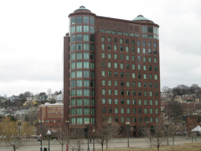
problematic ... to say the least. And One Citizens Plaza (
Figure 6) presents its own problems.
 |
| Fig. 5. Tight curve |
A better alignment is available, however. Thanks to highway engineers, (
Figure 7) we have decent, if still tight, curvature from Memorial Drive to the I-95 alignment. Continue on it a short way (about a thousand feet) and you can recurve back onto the existing alignment. And with this curve, we can bring Union Station back into play, instead of needing a new facility in tight confines.
 |
| Fig. 6. Like a giant middle finger sticking into the air |
At this point, the existing Providence Station is outmoded, and so too are the central Providence discussions in
PA and
RRPE. There is no way to make it from the 95 alignment onto its west approach--the curvature is just too tight. And because it is outmoded, once the replacement is built, the old facilities can be closed, subdivided, and resold.
 |
| Fig. 7. I-95 alignment |
A Headache
The biggest problem, however, is that of rethreading a reasonable facsimile of the old New Haven alignment through from I-95 to the East Side Rail Tunnel portal. While some of it is easy--there's a fairly clear station box from the Courtyard to the Woonasquatucket--much of it is difficult.
Chief among the difficulties are (a) those of weaving a rail line through the I-95/US-6/Memorial Drive interchange, and (b) dealing with One Citizens Plaza.
 |
| Fig. 8. Weaving a rail alignment into Providence's core |
First of all, however, we'll note that (c) that the East Side Tunnel portal has what appears to be +15' elevation with respect to Main Street. While we could undercut the tunnel's west approach and the westernmost part of the tunnel itself, the least expensive option requires utilizing as much of the old rail grade as is salvageable. As there is no room to grade a -30' difference (to -15' elevation with respect to Canal Street)--that would require 3,000' at a 1% ruling grade--and hence have a sunken station box and low bridge, and as route utilization mandates grade separation, we'll assume that the station box is at the historic Union Station level, i.e. +15' relative to Exchange Street. This drives elevation*.
This means that the solution to (b) is to route the station's east approach through One Citizens Plaza's south, well, plaza. In place of the plaza, a lobby extension and/or other use would front the Woonasquatucket-Moshassuck confluence; minor takings would be required for the necessary curvature to return to the original alignment. (Unfortunately, those buildings are obviously historic, but since some idiot went and built an office building right in the middle of the old alignment, you're kind of stuck between a rock and a hard place.) This section would be built on a trestle in order to encourage integration of "ground rights" under it by adjacent owners.
 |
| Fig. 9. New rail alignments in Providence's core |
For (a), this drives the elevation of the trestle
over the intersection of Memorial and Francis; the trestle's existence also has the handy side effect of forcibly road-dieting what is, by all appearances, a fairly ugly stroad. Further on, several interchange flyovers would need to be regraded and rebuilt as the railroad curves onto an embankment and heads down a 1.6% grade to make a 30' elevation change in 1900'. (Use
Figures 8 and
9, and
this file to help understand how the rebuilt grade is integrated into existing infrastructure.)**
Our final consideration is the station plant itself. We renovate and reopen the old Union Station waiting room and ticket offices, as well as provide a sheltered concourse in the old underpass; secondary platform accesses are on Exchange Street. The box, trestled, allows for active uses under it; the smallish, redundant greenspace cater-corner to Burnside Park--a beautiful common--would be eliminated in favor of TOD, as would the larger, also-redundant greenspace between the current Providence Station, Providence Place mall, and the State House greensward. (Among other things, development would better frame the State House along Francis St.)
_____________
*Much to my chagrin. I really wanted it to be sunken.
**One elegant solution would be to rebuild the interchange as one large surface roundabout, with routes feeding into it from US-6, I-95, and Memorial Drive.


No comments:
Post a Comment