
 |
| Newport, Jersey City. It's telling this -- not a streetscape -- is the beauty shot. |
 |
| Abandoned Pavonia Terminal from sometime in the '70s |
The developer promptly razed the site flat (including the old terminal building)** and built a shopping mall and office park in its stead. As site development -- still incomplete -- continued, modern retail has been built west of Washington Ave. (in particular, a large power center north of Newport Parkway), and more recent residential shows the effects of radical change in urban theory.***
 |
| Building mass models of north and south Newport |
That's because the eye is caught by proximate activity. When this activity is not well displayed, or is broken up by excessive greenswards (which also serve to decant park use, thereby making each greensward less interesting) -- both of which are the case in south Newport -- the street becomes significantly less pleasant. The more green "open space" a site has, the worse it's framed, the less concentrated its use, the less urban the neighborhood. Despite the river walk -- a key amenity -- this is clearly seen in south Newport.
Fortunately, it's easy to calculate open space -- it's how much of the site isn't, in fact, built on. That is, it's the opposite of a site's building coverage.
 |
| North and south Newport |
So, for north Newport, we find that:
- 3.83 acres are covered by buildings
- 1.46 acres are green space
- 0.00 acres are "car" space
For south Newport, by contrast:
- 12.48 acres are covered by buildings
- 10.32 acres are green space
- 3.48 acres are "car" space
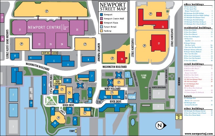 |
| Actually, the site plan shows even more open space, perhaps as much as 60% |
But what about the undeveloped parcels? There are three undeveloped sites around Newport Green Park, totaling 13.06 acres. Assuming they are developed to the same density as north Newport^^, that yields 3.60 acres of open space, or 9.6 acres covered by buildings^^^.
If we consider "greater north Newport" to be the sum of developed north Newport + undeveloped north Newport + Newport Green Park (4.93 ac), that yields 24.02 acres. According to our methodology, 9.99 acres of that will be open, or 49.6% of the site. This compares favorably with south Newport's 52.5%.
 |
| Can this be replicated elsewhere in Newport? |
Yet because of choices in how the "open space" is placed, north Newport's 49.6% will be far more effective, and far more heavily used, than south Newport's 52.5%.
That's because north Newport's open space won't be decanted into small enclosure-destroying plazas and port-cocheres the way south Newport's were. Instead, it'll be concentrated into one well-sized neighborhood park, a place that's already well-loved, despite the fact that but a single development abuts it.
_________
* It is notable that the Erie-Lackawanna's other predecessor railroad, the Delaware, Lackawanna & Western, had built what was perhaps the best non-Pennsylvania Railroad freight route from New York west. But when I-80 was built through Paterson, the State bought part of the E-L's low-grade mainline; freight movements on the replacement route, a commuter branch now part of the New Jersey Transit's Montclair-Boonton Line, proved less than ideal (and is, in fact, cited as a contributing factor as to why the E-L failed to outcompete its collapsing competition). Had the E-L retained the track connection through Paterson, it is likely that Conrail would have favored that -- shorter -- mainline to Buffalo, which in its turn would have favored more intensive passenger use of the Water Level Route -- today's Empire Corridor.
** Which should have been preserved and renovated IMO.
*** Or possibly just the success of Battery Park City (built by the same developer). Though, that said, Battery Park City has perhaps the blandest streetscape of any Manhattan neighborhood.
^ Incidentally, fully planned as early as 1939, which helps explain the unusual insertion of a Main Street when similar postwar projects (cf. Lafayette Park, Co-op City) favored small strip malls.
^^ Which may or may not be likely.
^^^ But what about streets? There has to be automobile access, especially on the huge northernmost parcel!
_________
* It is notable that the Erie-Lackawanna's other predecessor railroad, the Delaware, Lackawanna & Western, had built what was perhaps the best non-Pennsylvania Railroad freight route from New York west. But when I-80 was built through Paterson, the State bought part of the E-L's low-grade mainline; freight movements on the replacement route, a commuter branch now part of the New Jersey Transit's Montclair-Boonton Line, proved less than ideal (and is, in fact, cited as a contributing factor as to why the E-L failed to outcompete its collapsing competition). Had the E-L retained the track connection through Paterson, it is likely that Conrail would have favored that -- shorter -- mainline to Buffalo, which in its turn would have favored more intensive passenger use of the Water Level Route -- today's Empire Corridor.
** Which should have been preserved and renovated IMO.
*** Or possibly just the success of Battery Park City (built by the same developer). Though, that said, Battery Park City has perhaps the blandest streetscape of any Manhattan neighborhood.
^ Incidentally, fully planned as early as 1939, which helps explain the unusual insertion of a Main Street when similar postwar projects (cf. Lafayette Park, Co-op City) favored small strip malls.
^^ Which may or may not be likely.
^^^ But what about streets? There has to be automobile access, especially on the huge northernmost parcel!


