Monday, September 29, 2014

Kansas City Can Do It Better

(This post started as a fork from the previous post, The Streetcar Fiasco.)

Let us recall, for reference,  Width, and the Perception of Width and Multiway Boulevards, Transit Avenues.

Kansas City Streetcar render
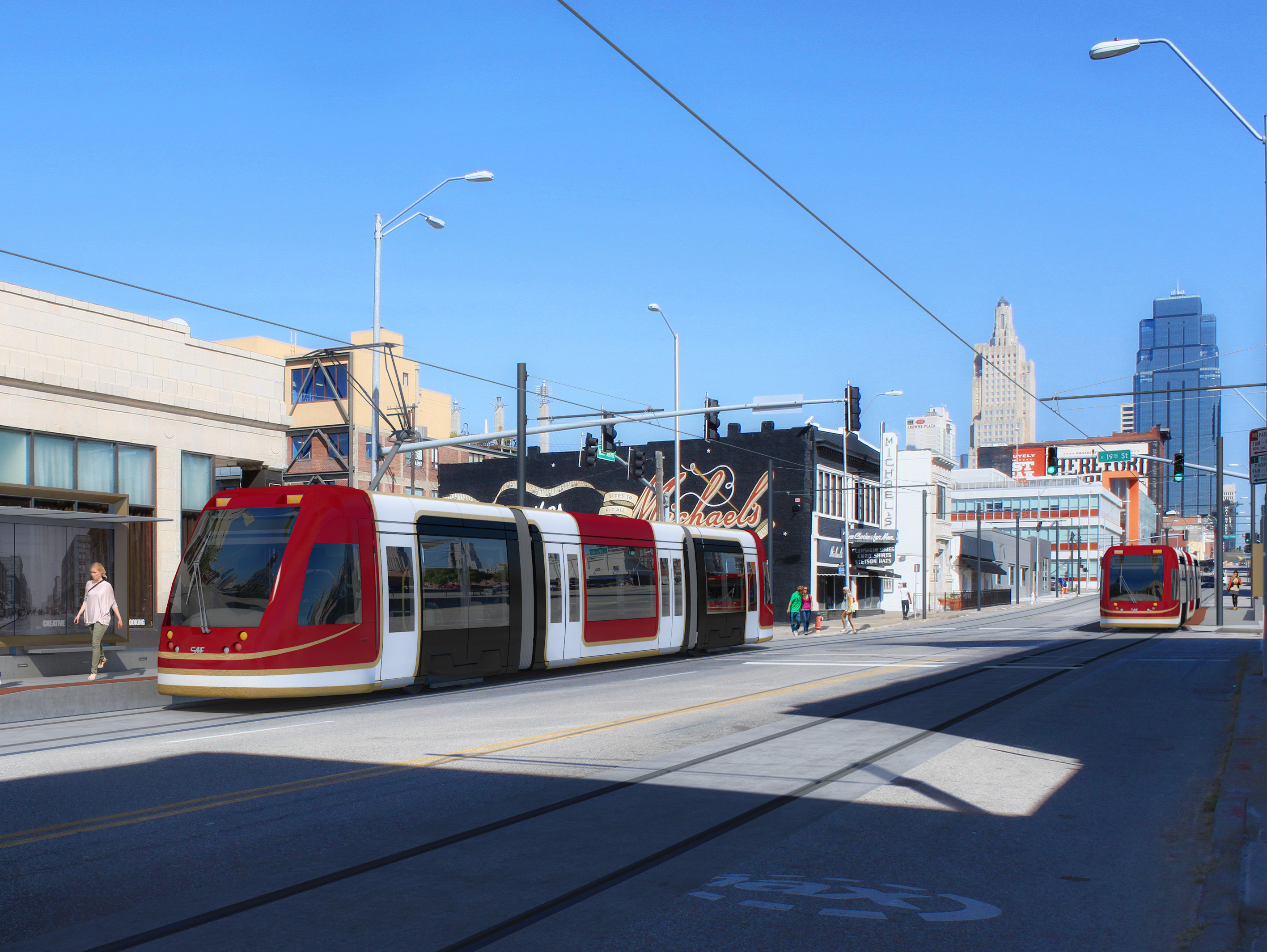
Kansas City's Main Street is only 80 feet wide -- 10 feet narrower than H Street -- but has nothing like the latter's congestion. Yet there are two southbound lanes and one northbound lane, and during "peak" periods the parking lanes turn into bus lanes. The streetcar is a mere drag-and-drop effort into the existing system.
The narrowest a street can be and still have full light rail is a mere 70 feet. At this width, several compromises have to be made, sure -- in particular, on blocks hosting stops, parking lanes need to be removed -- but they are as nothing compared to the scale of the compromises that need to be made on
60-foot streets. And remember, Kansas City's Main Street is a -- measured -- 80 feet wide.
Sample (pre-Streetmix) sections
In fact, we can have our cake here and eat it too. The nature of Kansas City's layout allows us to route core bike infrastructure on Broadway Boulevard and Grand Boulevard, which gives Main Street plenty of room to handle all of light rail's needs. Like so (with a parking space where the stop isn't).
A second option would be to kill parking spaces on one side of the street. It may be preferable to construct a street layout like this between stops. (Note that, in this layout, the parking space may also be claimed as a parklet where sufficient pedestrian energy to do so exists.)
In both, however, it becomes evident there is plenty of space for proper light rail, instead of copying a failed experiment from elsewhere in the country. More creative thinking's all that's needed.

Well, that, and a willingness to give up traffic lanes.

Friday, September 26, 2014

The Streetcar Fiasco

Streetcars have become a major fad over the past few years, ever since Portland put in theirs.
Portland Streetcar
In Portland's case, the streetcar is a pretty decent investment: it acts as a circulator overlay on a high-quality light rail system. But after they put theirs in a bunch of other cities began to construct streetcars for themselves.
H Street Line, Washington, DC
DC's H Street line was the second major streetcar; it is also the first that suggested an underlying problem. You see, H Street is supposed to be a spine corridor, linking the city's east side with its west. It thus needs to be built to a higher standard capacity than ... that.
This particular design -- at the time, novel* -- contains two catastrophic mistakes that permanently mar this line's capacity:
  1. The line has been built in a mixed traffic lane rather than be given its own dedicated lane. This reduces the streetcar's speed and makes it no better than a bigger bus on rails. Part of what makes light rail successful** is the dedicated lane. Without this lane the line is unable to bypass car congestion and thus provide the positive time differential that helped justify e.g. Salt Lake's investment.
  2. The line has been built in the outer lane. This second point makes it own strange kind of sense -- once you've decided not to build a dedicated ROW, there's something vaguely suicidal about asking passengers to run across a traffic lane unless you're willing to put carstops in, and if you're doing curb bumpouts as well, then why not put those there? However -- by putting the streetcar track in the outer lane you create conflicts between the streetcar and parallel parkers, delaying the transit vehicle for a single driver. These kinds of conflicts slow down vehicles on our country's remaining historic streetcar lines all the time -- one of the reasons Boston's Green Line is one of the most reliable is because (unlike the examples in Philly, Toronto, and San Francisco) the vast majority of the surface system lies in dedicated medians.
H Street was a difficult design challenge. The street is, surprisingly, 90 feet wide, and it is fairly congested -- its AADT hovers a little above the max capacity of a two-lane street -- and a full light-rail buildout would have likely required (among other things) taking of a parking lane significant street reconfiguration, much like 1st Street in San José, a bright spot in the VTA system.
1st Street, San José
Indeed, it is arguable that the H Street Line's optimal placement would have been for the light rail to lie between the sidewalk and the parking lanes, with a road diet reducing auto capacity just enough to convince (some) drivers to Take Other Routes. This arrangement, however, remains problematic in its own right, and is not the thrust of this post -- and I have talked about these kinds of things before.
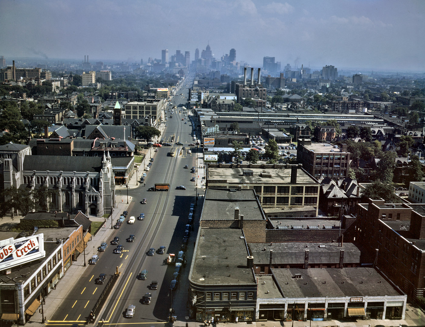
Woodward Avenue, ca. 1942. Note that even then there was little real congestion.
M-1 Streetcar plan reveals same engineering failures as H Street -- this time, with even less excuse.
At least two Midwestern cities have taken the (failed) H Street approach and applied it to themselves: Detroit and Kansas City. I haven't been to Detroit, but I will note that Woodward Avenue, which is eye-poppingly wide relative to traffic, can easily accommodate every single mode, if the designers chose to.
Kansas City Streetcar render
What is perhaps most shameful is that within these ... things ... lies the fact that the powers-that-be continue to refuse to give up any street space for cars, no matter how ridiculous the car gluttony may be *cough cough Detroit, Kansas City cough cough*, and are packaging it as a political sop to Millennials.

No. The transportation investment that would please us the most is in quality bike infrastructure. We want to ride around everywhere. Bike-friendly cities are Millennials' cities.
____________
* Portland's downtown streets are only 40 feet wide; historic streetcars ran in the middle of the street. (See, for example, Philly's trolleys.)
** And good BRT -- Cleveland's Euclid Avenue being the only such example in the United States today.

Thursday, September 25, 2014

Kansas City: Challenges

In my last post I talked about the potential Kansas City's rail alignments offer. Now I want to discuss the challenges.
Fig 1. Here we see Kansas City's essential commuter rail problem: the rail axis (red) is essentially orthogonal to the urban axis (black). The red and the black. Heh.
Locals and expatriates may have already realized the most significant challenge: namely that, unlike in e.g. Munich, Kansas City's urban core is pretty much orthogonal to the proposed regional rail core (Fig. 1). They intersect, in fact, at Union Station. This undermines the vast majority of urban-centered uses (although the Peculiar Line offers a connection to Swopes Park and hence the Zoo). To put it bluntly, Kansas City's urbanity and attractions are on a different axis entirely relative to where the trains go.

While a challenge, this is not an insurmountable problem. Union Station is adjacent to two major districts in its own right, and skillful connection-making with the Main Street corridor -- which is the urban axis, and one that desperately needs light rail -- allows for the distribution pattern, north to downtown and the River Market, and south to Westport, Country Club Plaza, and Brookside, needed to tie the regional system in with the urban system.

It is notable that the Market-Frankford Line (the El),  Broad Street Line (subway), and Subway-Surface Lines (trolleys) have similar roles in Philadelphia; our major urban playgrounds -- Fishtown/Northern Liberties, Old City, Passyunk Square, Fairmount, and University City -- are about as far afield of each other as they are of Center City proper. We often come in on Regional Rail and transfer to these other modes.*

Fig 2. Here we see the lack of routes to KCI. A potential alignment (black) is given.
A second issue (Fig. 2) is the lack of any route to Kansas City International (KCI). While several commentators point out the relative lack of cost-effectiveness of airport links in their own right, if one is "on the way" service to it is naturally justifiable. Wheeler Airport is alongside the Missouri Bluffs Line, for example; service to it is natural and intuitive. But KCI is a far larger and more important facility, and is extremely far from anything on-the-way. Reaching it would require some sort of shuttle service, if not a new alignment (redirection of the Missouri Bluffs Line? AirTrain?) of some sort.
Fig 3. Rail v. highway alignments in eastern Kansas City. Note how rail will be hard-pressed to compete on any sort of time advantage.
Finally (Fig. 3) one of the most difficult aspects of commuter rail is the fact that all the various alignments funnel into the Union Station approach in the northeast of the city proper. While not a particular issue for intercity rail, it is problematic for commuter rail -- especially the Peculiar Line -- whose run from Grandview to Union Station (Crown Center) is about 4.5 miles longer (~22 miles) than the shortest highway alignment -- US 71 to the south Loop (~17.5 miles). Assuming the train's mean velocity is 30 mph, this yields a 45 minute schedule time; contrast this with half an hour in clear traffic (50 mph average velocity**) and broadly equivalent time (42 mins) in free flow modulated by the worst stop-and-go Kansas City has to offer (average velocity: 25 mph)***.

On the coasts, we often find that riders are willing to sacrifice a certain percentage of their time for the luxury of not having to drive^. Even so, we find that commuters shy away from commutes lasting more than an hour. This leaves open the question: if the runtime into Union Station is 45 minutes, then can we ensure that the final phase of the trip (assuming it's not terminating at Crown Center) is only in the 15-minute range? This, too, can be solved by offering close connections with a light rail trunk along Main Street (as noted above)^^.

To summarize: Kansas City has significant advantages in developing a commuter rail network -- but the currently available alignments are not without their drawbacks. And since the city core was developed along streetcar trunks and grand boulevards rather than along the railroads (the paucity of railroad suburbs is notable, and is probably one of the major reasons the urban region remains relatively compact), there are going to be investment thresholds that have to be met to offer service at a quality good enough to tap the necessary markets to be justifiable.

The largest challenge is that -- in Kansas City especially -- for commuter rail to be viable, it will have to be linked into a high-quality mass transit system^^^. In much of the Midwest, here included, "quality" and "mass transit" remain a contradiction in terms.
___________
* A second aspect is that other playgrounds, further out (Mount Airy, Chestnut Hill, Manayunk, the Main Line) are well-connected with the Regional Rail system as well. Consider, then, the Turkey Creek Line, which goes to Olathe, the Independent Line to Lee's Summit, and the Lawrence Line to, well, Lawrence.
** There are random traffic lights and a not-insignificant 45 mph stretch along this route. Also people do weird things in Kansas City like follow the speed limit -- even in the 90+% of instances where it's nonsensical.
*** Maths: We are not attempting to calculate acceleration (i.e. acceleration is being considered a zero vector). Therefore the normal position equation under constant acceleration, s=vt-(at^2)/2, where s is position, v velocity, a acceleration, and t time, collapses to s=vt, which we then rebalance to t=s/v to obtain time (and convert from hours to minutes).
^ This needs to be modeled. We can see it anecdotally, and it happens often enough that it can no doubt be statistically aggregated -- but how much is it?
^^ We're going to deal with what's currently being built on Main Street soon enough.
^^^ At least in the urban core.
Wednesday, September 24, 2014

Kansas City: Potential

So for various reasons -- some of which are probably related to hormones and such -- my thoughts have taken a recent Midwestern turn. In particular, I find myself interested in the two largest cities in Missouri, a state that is essentially two Pittsburghs with a whole lot of Lancaster County in between. Being interested in commuter networks, I immediately set about applying my tried-and-true coastal methodology to these cities to see what would pop out.

Since I was there recently, my first target is Kansas City.

I found myself surprised that there was a more substantive rail network there than I'd expected; indeed, when I did some research into it I discovered that the city used to be the Midwest's second-largest rail hub (a role I had assumed fell to Omaha, the Union Pacific's historic railhead and the reason why there were once easily half a dozen mainlines traversing Iowa). Considering it, however, reveals that it makes sense: all of the four major Eastern through routes -- Pennsylvania, New York Central, Baltimore & Ohio, and Alphabet route (via the Nickel Plate) had termini in Chicago and St. Louis; while the latter's role is customarily understated, it quickly becomes evident that there were few direct linkages between it and Omaha, and four between it and Kansas City (i.e. the Burlington, Rock Island, Missouri Pacific, and Katy). Kansas City thus served as a transshipment point for freight following the transcontinental alphabet route that began with the Western Pacific and followed the Rio Grande mainline across the Rockies, spreading into a raft of competing lines from Denver east. This trade route is followed by the modern I-70 corridor. It was also a principal interchange point of the Santa Fe and a handoff point where the mainlines of the major Texas-Midwest railroads (Katy, Missouri Pacific, Frisco, and Kansas City Southern) met those of the lines following the Missouri (or heading into Iowa) heading further north, towards Omaha and Minnesota. (This trade route is followed by the I-35 corridor.) All of this made for a list of about half a dozen major railroads heading into Kansas City: the Santa Fe, Burlington Route, Rock Island, Katy, Mo-Pac, Frisco, and Kansas City Southern. Nearly all of these had lines in from multiple compass directions.
Fig 1. Major alignments into Kansas City
We can see  this in Fig. 1, which shows the identifiable freight corridors into the city. Count 'em up -- there are sixteen of them! And that doesn't count lines that were almost certainly abandoned between then and now; it is easy to forget that railroads built the Midwest, and the largest cities were -- and still are -- rail hubs.

From these we winnow out several routes. Some pass through populated areas but are too circuitous; others run out through largely rural regions. We seek out a string of populous towns en route -- town center stations generally help revitalize these places while also providing a built-in ridership base. Kansas City's metro region is relatively small -- most lines are about 30 - 40 miles long. It is also one that does not have any significant all-day congestion (indeed, it clearly has auto capacity overbuild: you're lucky to get the 8:00 AM stop-and-go on US 71 at noon out on the Schuylkill heading towards King of Prussia, and many surface streets -- especially the most heavily-engineered ones -- have desertion issues, a clear sign of excessive capacity relative to demand); we thus need seek the most direct routes to Union Station, the city's lone major rail hub. A system such as we would demand in Chicago and the large coastal cities -- frequent all-day service -- is probably beyond any reasonable resource allocation; instead, we'll have to settle for high-frequency rush-and-periphery* service on the weekdays, medium-high frequency all-day service Saturdays**, and medium-low all-day service on Sundays. Union Station is a through-station so we'll be able to immediately run regional service; this requires line balance. Finally, the station approaches -- especially immediately west -- present extremely high-grade grade-separated passenger rail alignments; we seek to make use of these.
Fig 2. Key Corridors
From this we define the eight route (plus one branch) system shown in blue on Fig. 2.
  1. Beginning along the Missouri northwest of town and moving counterclockwise, we have the Leavenworth Line, which links Kansas City, MO, with Kansas City, KS, and with Leavenworth, KS, with its prison and fort.
  2. Next we have the Lawrence Line, which runs along the Kansas River west to Lawrence, tapping KU.
  3. Down in the southwest, we have the Turkey Creek Line, which runs along the Turkey Creek corridor through the richest part of the region towards Olathe and Spring Hill. If at all possible, we would like to add a branch to Gardner to this route (however, it does not appear this is possible).
  4. Directly south of the city is the Peculiar Line, which runs along the Blue River into the city and connects with Grandview and namesake Peculiar.
  5. Southeast of that, we have the Independent Line, which connects with Independence and Lee's Summit. This route should be the most heavily-trafficked on the east side.
  6. To its northeast is the Eastside Line, which runs out to Blue Springs.
  7. Jumping across the Missouri, we have the Excelsior Line, named after its Excelsior Springs terminus. It also sports a branch north to Kearney.
  8. Finally, we have the Missouri Bluffs Line, serving an area along the Bluffs.
Projected line pairings are as follows:
  • the Turkey Springs Line is paired with the Independent Line;
  • the Leavenworth Line is paired with the Peculiar Line;
  • the Lawrence Line is paired with the Eastside Line; and
  • the Missouri Bluffs Line is paired with the Excelsior Line.
These pairings strive to match considerations of demographics and length -- that is, we're seeking a Lagrangian balance of ridership and runtime. We're also attempting to have similar runtime throughout the system -- we want no run to take more than 60 minutes. Kansas City is small enough that none should.

Next we'll talk about Kansas City's major challenges.

___________
* I.e. around "the periphery of" rush hour. We'll also need late-night service more than noontime.**
** This is because we'll be seeking to tap two markets: first, conventional commuters (particularly to Crown Center, and secondarily towards downtown via the streetcar), and second, the out-on-the-town crowd that would prefer leaving their cars at home. There's also a student market, as most of the lines have at least a midsize school along them, and the terminus of the Lawrence line is KU. Finally, in one case, there's a major prison -- Leavenworth -- and its concomitant visitors' market.