Wednesday, June 24, 2015

Protected Bike Lanes ... Everywhere!

Kinzie St protected bike lane, Chicago
Protected bike lanes are a long time coming in Philadelphia. Five years ago, we were among the country's leaders in bike infrastructure -- back when buffered bike lanes were the big new thing -- but while other cities, such as New York, D.C., and Chicago, rolled out ever-more-extensive bike infrastructure, we ... regressed. Pointless "super-sharrows", an infrastructural solution now a decade out of date, were installed instead on Samson Street.

Even so, a cadre of geeks have been beating the drum to improve the buffered bike lanes we already have and install new protected cycle lanes. And it looks like we have some headway: Ryan Avenue linking Mayfair to the Boulevard in the Northeast is due to receive the city's first protected bike lane, and the Bike Coalition's now beating a drum for the installation of one on Chestnut Street in West Philly -- which yours truly first conceived of some three years ago now, back when the buffered bike lane on Walnut was installed.

This, as Tom Beck reports for Citified.

Part of the issue is spatial. Philadelphia's major core streets just don't have a lot of space, and in fact a lot of our bike-friendliness is because of that. It's not particularly suicidal to ride down, say, 6th Street in South Philly, where you have to be a douchy driver indeed to exceed bike speed. (Though we do have more than our fair share of douchy drivers.) It's much more difficult to ride along wider, overstriped streets with more traffic lanes than they really need. Sometimes, as is the case with 22nd Street in Fairmount, the extra space exists without the taking of a traffic lane -- but the political will does not. And Center City's principal buffered lanes, the ones put in before Ariel Ben-Amos moved over to the Water Department, all involved the taking of a parking lane to be put in, in the first place.

That said, there are definitely avenues in the city fit for protected bike lanes. Lots of them. In general, if there's a flush median a.k.a. a center turning lane a.k.a. a suicide lane, there's space for bike lanes on either side. And if both bike lanes and a center turning lane exist, there's space to make them protected. Here are more than a few examples.* And, though the old core might be largely bereft of places to put protected bike lanes, as you head out into the Northeast, there is plenty of underutilized space on streets such as Frankford, Castor, or Tyson avenues, space currently given over to passing lanes that makes crossing streets harder than it need be.

It might be all politics in the end, though. Bike commuting is concentrated around Center City, and most of the Bike Coalition's protected cycle tracks abet that. Despite the prevalence of striped lanes in the Northeast, it's still perceived as a place where one drives. And our 2.4% commute mode share is, in absolute terms ... not a lot. It'll take a commute mode share closer to 20% before bike commuting is thought of as something other than a "hipster thing" short of massive Millennial political coalition-building.
_________
* The one caveat we must observe is that major mass transit infrastructure, such as a busway or light rail line, has a natural priority over bike infrastructure. Indeed, this is the main difficulty with installing bike infrastructure on Girard Avenue. This is also what makes Erie the most difficult of the Bike Coalition's recommendations: the 56 uses the old trolley median (closed to traffic) as an impromptu busway. And, seeing as the route is one of the city's busiest, improving mass transit capacity along Erie takes precedence over improving bike infrastructure.

Monday, June 22, 2015

A Good Problem for the El

The Market-Frankford Line has a capacity issue. It's crowded during rush hour. And its crowding isn't just in Center City, it's end-to-end. Many people use the el to connect to the NHSL, 101 and 102 trolleys, and buses points west at 69th St., and buses points northeast at Frankford and Arrot terminals transportation centers. And with a ridership of just over 190,000 ppd, it is by far SEPTA's single busiest route, one that sees a surprising 60% more riders than the Broad Street Line.

Crowding indicates the el needs more space. As heavy rail -- infrastructurally, by far the highest-capacity of all modes -- any further capacity increases must come with relatively incremental improvements to the current physical plant. Some improvements are cheaper than others. A couple can be implemented immediately; others may take a little while longer. From cheapest to most expensive, we can:

- Use longitudinal seating. This one is by far the cheapest way to increase capacity, requiring nothing more than a refurbishment of the el cars' interiors, one which (they are halfway through their design lives) they are due for soon. It's also used in several other American subways -- notably, Boston and New York. Longitudinal seating decreases seating capacity, but it makes up for it by increasing standing capacity; it's also important to notice that in the current setup, the worst crowding occurs around the doors; longitudinal seating can help alleviate that.

- Convert to automatic train control (ATC). The el, like New York's 7 and L trains, is a single line with no branching. While no US transit agency has demonstrated the expertise to more than ~25 tph with human-driven subways (the MTA tried once and it failed miserably), ATC allows trains to be programmed to run at any frequency so desired. Increasing the frequency increases the runs a given trainset can make, which in turn increases overall line capacity. Indeed, when the 7's ATC installation is finished later this year, the line's peak frequency will be 28 or 29 tph -- just shy of one every other minute.

- Use full vestibules. There's a lot of unused space between the el's train cars. Use of full vestibules -- essentially, an articulating chamber between the cars (much like the one on articulated buses) -- would add a lot of usable space within the boundaries of the train. 10% more, in fact. Fun fact: full vestibules are now found on metros in every single country that uses them ... except the US.

The problem with this is that the current equipment is halfway through its life cycle and full vestibules would have to be a design requirement for their replacements. It would also require a rethink of el trains from a triplet of married pairs back-to-back-to-back to a single six-car unit. Indeed, thinking of trains as assemblages of cars rather than unitary bodies in their own right is often cited as the main reason why the US (whose railroad engineering expertise stalled in the 1950s) doesn't use full vestibules.

One can also argue that a full-vestibuled trainset naturally locks train length in for the duration of its life cycle. But that is only an issue if we are actively pursuing infrastructure for longer trains.

- Lengthen the platforms. Another way to increase the el's train capacity is, naturally, to use longer trains! But train length is currently proscribed by the length of the system's shortest platforms: therefore, it makes sense to increase platform lengths if we want to, well, platform longer trains. This is particularly problematic on the West Philadelphia elevated, whose platforms should have been extended to handle seven- or possibly eight-car trains in the recent rebuilding; the 2nd, 5th, 8th, and 11th St el stops, which can can only platform six cars and require tunneling to increase platform lengths; and the 69th St Terminal Transportation Center, where the track design of both platform approaches may well actually preclude any lengthening. Easier are the Frankford el's shorter platforms, which are now more than 20 years old and can conceivably be rebuilt to handle longer trains during a modernization program in the not-too-distant future.

The downside of this is that, if you're already using full vestibules, the benefits of lengthening the platforms comes not when you've lengthened the shortest platform, but rather once you've replaced the trainsets with ones that take full advantage of the longer platforms. Of course, this can be spun: Great! Our new self-driving, longitudinal-seating full-vestibuled trains increase capacity by some 25%! Now we have some thirty-forty years to lengthen all the platforms so that we can run longer trains and further alleviate crowding now that the easy stuff's done!

- Build an express track. This is perhaps the most difficult of the incremental investments. While the original plan for the el was for it to run express through Center City, and the trolleys local -- the trolley tunnel from 15th to 32nd being therefore incorporatable into an express line -- PRT, the el's original builder, was never able to finish the scheme, having run out of money by the time the line reached City Hall and only able to raise enough to build half of the system for the last (and most expensive) mile. As a result, the West Philadelphia and Frankford els were never designed to incorporate an express track, and there's a fair possibility the latter may not be able to, either. (Market Street is much wider, so you've got more room to work with.)

All that said, the fact that el crowding doesn't drop off as you head further out, but is rather end-to-end, makes it useful to look at an express track (perhaps as a couple of short segments of timed overtakes?) Such a track would offer a useful second service for passengers heading to 69th St or Frankford and thereby free up local capacity for interstitial stations.

- Build an interceptor line. Not remotely incremental, this -- by far the most expensive solution of all -- builds a new line that siphons off some of the el's traffic at its source. Built as planned, a Boulevard subway would function as this: it would intercept most of the traffic on the 14 bus and near the Boulevard, as well as (assuming a convenient transfer) buses on Bustleton, Oxford, and Castor avenues, leaving primarily the 66 feeding into the el.

Interceptors would also have to function as lines in their own right. This is either a feature or a bug: by intercepting most passengers taking the train to Frankford, you've opened up a lot of capacity. Capacity that can get filled up. In fact, the Media/Elwyn and Paoli/Thorndale Lines are both arguably interceptors for the el (via the 101 and 102 for the former, and the NHSL and 105 for the latter) ... and are themselves heavily used. Essentially, patronage has expanded not just to fill the core line but the lines built to alleviate capacity by intercepting it.

The Boulevard subway was last projected to have the same passenger counts the el today "enjoys", a fair percentage being intercepted el passengers. But it's more than likely that that capacity would quickly get filled up, and the el run at capacity again.

So it's good to think of new lines, and think of new lines not just in their own right, but how they would fit into the network; but to propose a new line solely to alleviate the capacity problems of another is not so good an idea. Induced demand is just as true for mass transit as it is for cars and bikes.

Friday, June 19, 2015

A Minneapolis Councilwoman's Land-Use Masterstroke

Saw this quote in this article:
The Minneapolis policy, proposed by Council Member Lisa Bender, would eliminate all parking requirements for new residential units built within 350 feet, or about a block, of bus or rail service offering frequent, all-day service (every 15 minutes at midday). Within a quarter-mile of frequent bus service and a half-mile of frequent rail service, the policy change would eliminate all requirements for buildings with 50 or fewer housing units, and reduce them to one space per two units for projects larger than that. For developments within 350 feet of infrequent bus service—coming only 30 minutes at midday—the policy would reduce current parking requirements by 10 percent.
Mrs. Bender is truly brilliant. Not only is she proposing what is perhaps the most progressive parking reform in the country, she is doing so in such a way that ties parking to mass transit accessibility. IOW, the closer you are to mass transit, the less parking you need.

She isn't just proposing a law, she's proposing a template of a law. One that can easily be replicated anywhere with a good mass transit core.

For instance, if you applied a similar requirement here in Philadelphia, the scale of our core network is such that parking requirements would be waived entirely for the overwhelming majority of the inner city. It would look not dissimilar to Yonah Freemark's map of Chicago parking requirements.

Wednesday, June 17, 2015

Success ... by a hair's breadth?

As if in a coda to my post the other day, Plan Philly brings news of the apartment project at 43rd and Baltimore -- across the street from Clark Park. It went before the Zoning Board seeking variances, doing so after:

  • Extensive community input shaping the development vision
  • Jannie Blackwell rejecting spot-zoning proposal
By the time it got to the ZBA, the project had racked up letters of support or nonopposition from every single involved party. Yet there were, in the meeting, two dissenters:
At a hearing in April, the developers sought variances for height, 35 feet more than the underlying zoning allows, and commercial space. It was supported by local civic groups and Councilwoman Blackwell’s office, but opposed vociferously by two neighborhood residents who live a few blocks from the property. 
Mary McGettigan and Larry Caputo, the opponents of the project, noted that the project didn’t conform to either the existing or proposed zoning of the property. They argued that the developers hadn’t made their case that the zoning designation represented a hardship on the property.
The ZBA voted to support this project. But it only did so by a 3-2 margin. This, despite the fact that the developers had gone above and beyond in incorporating the community voice in their design. It's fairly clear that -- had there been no dissenters who showed up at the meeting -- the project would have sailed through the ZBA.

Two dissenters.

That's all it took to nearly derail a small apartment building that is in scale with a number of similar buildings scattered throughout the neighborhood.

As if you needed any more evidence modern zoning is excessively restrictive!

Tuesday, June 16, 2015

What works

These concrete tree thingies that seem to be generally Brutalist have proven to be aesthetically successful over time. A combination of simple geometric features emphasizing the use of (reinforced) concrete and glass, a simple cantilevering, and a layout that manages to evoke traditional columnular layouts while at the same time offering characteristically Modernist light airy spareness.

The example shown above is the Katowice train station, demonstrating how this style is particularly effective for structures whose principal organizing element is a large, open main hall.

Monday, June 15, 2015

Zoning, the Static City, The Dynamic City

At the beginning of the year, Charlie Gardner at Old Urbanist offered an academic's findings on zoning, especially where American practice is in conflict with European practice. Perhaps the most important part, however, is a paragraph buried deep in the piece:
How this exceptionally American land-use system came into being during the late 1800s and through to the 1930s is the primary focus of Hirt's book.  In chronicling this period, many apparent paradoxes present themselves: for instance, although the United States of the late 19th century prided itself on being the most democratic nation in the world, its citizens had a low level of trust in their elected municipal officials.  The progressive municipal reformers of the time might therefore have campaigned for planning to be guided by state or federal governments, but instead pushed for non-discretionary municipal-level zoning.  As Hirt observes, zoning reformers such as Lawrence Veiller argued that "zoning rules should vary as little as possible in districts that were as large as possible and that zoning relief should be granted only under a very limited set of circumstances, if at all." 
But if the planning powers were delegated from state to city, and the city was to have little power to alter the apparently infallible choices of the initial zoning commissions, who was left to actually engage in city planning?  No one, as it turns out.  Planning commissioners were seemingly intended to be little more than curators of the city zoning map, and Hirt finds, as I have also noted, that zoning maps have changed relatively little in their basic allocation of space since the 1920s.  As I've written about before, the actual policy that zoning was intended to serve was almost an afterthought, and was primarily concerned with protecting the investments of wealthy homeowners.  By default, and perhaps unintentionally, city planning (to the extent it existed at all) was turned over to the emerging highway engineering profession. 
American zoning policy, in sum, was a negative and reactive vision -- through its implementation, it viewed cities as incapable of honest and effective self-government, and by its actual regulations, it viewed urbanization as a threat to not only investments but to civic spirit and even the American way of life itself. As Hirt writes, "[t]he single-family home had the right to the city: it was always seen as being there first. It was the gracious host, the delicate victim, and the original citizen that was always haunted, followed, invaded, and taken advantage of by other housing types." In this sense, Hirt's book echoes the conclusions of Steven Conn's recent Americans Against the City: Anti-Urbanism in the Twentieth Century.
The key takeaway of this is fairly simple: American zoning was already being used as a tool to prevent redevelopment as early as the 1920s. Zoning theory, while it grew out of nuisance law and European (especially German) practice, was already being adapted to exclude rather than include -- zoning, by design, is a hyperlocally-devolved tool. Indeed, the basic idea seems to have been to zone land such that intensification of existing development was made impossible, a practice which inevitably would concentrate redevelopment in the most intensively-used areas -- and on the greenbelt edges. 

And because there was no systemic planning practice designed to rezone, it has been left to politicians' whims, which often result in downzonings once communities realize that existing zones allow more intensive land use than what currently exists, and state DOTs -- whose highway extensions (and not mass transit extensions) have been, since midcentury, what has opened new land up to development.

What is curious to note, then, is that American sprawl is driven by what is essentially a units problem. In the hard sciences, units problems rise when units are misapplied, or when they're inadvertently mixed. For example, while a velocity calculation might be mathematically simple under constant acceleration, the result has to be in the same units as the inputs (e.g. m/s, cm/s, mi/h, etc.). Mix up the units -- say, by measuring an object's weight when what you want is its mass -- and you throw your calculations off. Similarly, inappropriate aggregation can often hide more than it illuminates: this is one of Jane Jacobs' key critiques of mainstream macroeconomics, that the sovereign nation is fundamentally an inappropriate unit for economic measurements, as it almost always represents an aggregation of very much economically disparate regions. 

By over-empowering land use planning at the hyperlocal scale, we inadvertently disempower reasonable land-use planning at the scale where it matters most, as far as optimizing spatial efficiency relative to amenitization is concerned: the greater conurbation. Static land use paradigms undercut the efficacy of mass transit (as has often been pointed out at Urban Kchose); because zoning law is not designed with spatial efficiency in mind -- and, indeed, almost every solution to any given land-use problem increases spatial inefficiency -- we find ourselves unable to respond save by sprawling more ... and more ... and more.

Sometimes small-scale intensification is not aesthetically pleasing: witness D.C.'s pop-up house, which, now that one has been built, has been banned. Indeed, this has generally been zoning's modus operandi -- regulate nonconformity into nonexistence. The problem with this is, however, that at a certain level, small-scale intensification requires aesthetic flexibility. Indeed, this may be old urbanists' strongest criticism of New Urbanism: that it overfocuses on form, while underfocusing on the land-use development process -- the true locus of the sprawl process. This is perhaps where Strong Towns has come into play: it has gained traction and has been growing, as a grassroots movement, precisely because it has correctly identified the core problem: a broken process: a process that enshrines a static, rather than dynamic, vision of the city.

But here is an interesting issue, and once where there might actually be natural friction between Strong Towns and old urbanists: short of total curtailment of land use regulation (an extremely libertarian solution), while the issues in transportation engineering are clearly defined by its excessively top-down paradigm, the problems with spatial planning are caused by it being excessively bottom-up. That is, resistance to change is driven not by new inhabitants but by the ones who already live there, and have the time and energy to mount opposition (which, due to the way the playing field is skewed, is almost always effective opposition). Even very simple changes -- for example, liquidation of excessive parking regulation, making small multiunit structures legal, moderate height increases, and other examples of incremental redevelopment -- are opposed so fiercely that, outside of large urban cores where an effective development counterpresence can be built, they are unlikely to get any traction.

The long and the short of this can be summed up by saying: The current land-use planning paradigm is fundamentally broken. Moreso, it is fundamentally broken because current American regulation creates a static vision of the city, rather than a dynamic one; this fundamentally empowers interests that favor their static vision (NIMBYs) while disempowering ones whose vision is dynamic (developers). And, despite many planners' attempts to make dynamic redevelopment easier, the truth is that the discipline's entire toolkit, over-oriented towards a static vision, greatly inhibits what can be done, and yields marginal results of even the most sweeping efforts.

Thursday, June 11, 2015

South Newport: Or, A Case Study On Why "Open Space" Is Bad

So I stumbled across this post the other day. In it, the poster argues that, while the northern half of Jersey City's Newport district seems to have made an attempt at Vancouver-style urbanism, it does not succeed to the degree Vancouver's does.
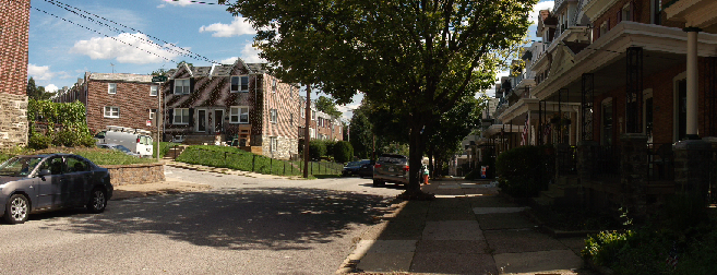
Newport, Jersey City. It's telling this -- not a streetscape -- is the beauty shot.
This is not an unfair claim. Having been in Newport a couple of weeks ago (because Reasons), I can confirm with my own eyes that, while the River Drive is a reasonable urbanism, and the corner of Washington Boulevard and Town Square place has -- even when it decides to rain -- more than enough people to overcome its inferior site design, the southeast corner of Newport is a weird corner of buildings spaced too far apart: a sense of enclosure is lacking, and the buildings don't really capture as much commercial energy as they ought to (despite the existence of excellent sushi and boba tea joints).
Abandoned Pavonia Terminal from sometime in the '70s
In large part, this is because Newport's first phase dates to the late '80s: up to about 1960, the site was home to the Erie Railroad's Pavonia Terminal, a handsome Victorian edifice. Photos from the '70s show the passenger terminal as having fallen into ruin (though it is unclear whether the Erie's successor, the Erie-Lackawanna, had freight facilities in the area). By the early '80s, the bankrupt E-L was absorbed into Conrail, along with a whole bunch of other railroads; it focused its freight landport at the old Lehigh Valley (another bankrupt railroad)'s Oak Island Yard in Newark's Ironbound.* The complete abandonment of  the E-L's waterfront facilities soon followed.

The developer promptly razed the site flat (including the old terminal building)** and built a shopping mall and office park in its stead. As site development -- still incomplete -- continued, modern retail has been built west of Washington Ave. (in particular, a large power center north of Newport Parkway), and more recent residential shows the effects of radical change in urban theory.***
Building mass models of north and south Newport
The Urban Prospector shows a Sketchup mockup of both the southern and northern parts of Newport, focusing on the long streetscape gaps to the south. Those gaps are the ultimate end-result of the planning of the day, which favored generous "open space": the Modernist tower-in-a-park paradigm. While towers-in-parks and commercial aren't necessarily antithetical to each other, it is notable that in examples where commercial has successfully been integrated into towers-in-parks, such as Metropolitan Ave. in Parkchester, the Bronx,^ it is built to the street, taking over the green space.

That's because the eye is caught by proximate activity. When this activity is not well displayed, or is broken up by excessive greenswards (which also serve to decant park use, thereby making each greensward less interesting) -- both of which are the case in south Newport -- the street becomes significantly less pleasant. The more green "open space" a site has, the worse it's framed, the less concentrated its use, the less urban the neighborhood. Despite the river walk -- a key amenity -- this is clearly seen in south Newport.

Fortunately, it's easy to calculate open space -- it's how much of the site isn't, in fact, built on. That is, it's the opposite of a site's building coverage.
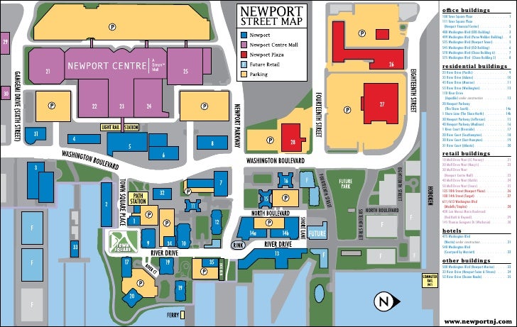
North and south Newport
For this exercise, I decided to consider "North Newport" the developed part of River Drive north of Newport Parkway. (The southwest corner of Newport Drive and 14th Street is clearly a parcel that hasn't been developed yet, not a public or semipublic green space; the same holds true for the piers.) South Newport is considered the part of Newport that extends from Newport Parkway down to Thomas Gangemi Drive east of Washington Boulevard. I was also interested in how much of the open space is given over to car use (storage, mostly). Finally, I disregarded the street, considering it public right-of-way. Here is the map yielding the polygons I used.

So, for north Newport, we find that:

  • 3.83 acres are covered by buildings
  • 1.46 acres are green space
  • 0.00 acres are "car" space
This means that there are a total of 5.29 developed acres in North Newport, of which a mere 27.6% is "open space", arranged as part of the riverside park and a small plaza.

For south Newport, by contrast:

  • 12.48 acres are covered by buildings
  • 10.32 acres are green space
  • 3.48 acres are "car" space
Summing this up, we see that there are 26.28 total acres in south Newport, of which 13.8 acres are "open space", some 52.5% of the site. A surprisingly low 33.7% of the "open space" is actually devoted to cars: its high visibility has urban fabric-destroying impact, however.
Actually, the site plan shows even more open space, perhaps as much as 60%
But what about the undeveloped parcels? There are three undeveloped sites around Newport Green Park, totaling 13.06 acres. Assuming they are developed to the same density as north Newport^^, that yields 3.60 acres of open space, or 9.6 acres covered by buildings^^^.

If we consider "greater north Newport" to be the sum of developed north Newport + undeveloped north Newport + Newport Green Park (4.93 ac), that yields 24.02 acres. According to our methodology, 9.99 acres of that will be open, or 49.6% of the site. This compares favorably with south Newport's 52.5%.
Can this be replicated elsewhere in Newport?
Yet because of choices in how the "open space" is placed, north Newport's 49.6% will be far more effective, and far more heavily used, than south Newport's 52.5%.

That's because north Newport's open space won't be decanted into small enclosure-destroying plazas and port-cocheres the way south Newport's were. Instead, it'll be concentrated into one well-sized neighborhood park, a place that's already well-loved, despite the fact that but a single development abuts it.

_________
* It is notable that the Erie-Lackawanna's other predecessor railroad, the Delaware, Lackawanna & Western, had built what was perhaps the best non-Pennsylvania Railroad freight route from New York west. But when I-80 was built through Paterson, the State bought part of the E-L's low-grade mainline; freight movements on the replacement route, a commuter branch now part of the New Jersey Transit's Montclair-Boonton Line, proved less than ideal (and is, in fact, cited as a contributing factor as to why the E-L failed to outcompete its collapsing competition). Had the E-L retained the track connection through Paterson, it is likely that Conrail would have favored that -- shorter -- mainline to Buffalo, which in its turn would have favored more intensive passenger use of the Water Level Route -- today's Empire Corridor.

** Which should have been preserved and renovated IMO.

*** Or possibly just the success of Battery Park City (built by the same developer). Though, that said, Battery Park City has perhaps the blandest streetscape of any Manhattan neighborhood.

^ Incidentally, fully planned as early as 1939, which helps explain the unusual insertion of a Main Street when similar postwar projects (cf. Lafayette Park, Co-op City) favored small strip malls.

^^ Which may or may not be likely.

^^^ But what about streets? There has to be automobile access, especially on the huge northernmost parcel!

Wednesday, June 10, 2015

What does $777.3 million buy you?

According to the Business Journal, American Water is getting a $164 million tax break to move to Camden.

This is on top of this short list of other companies who have been bribed into moving into Camden:

Here are a few other companies that have moved to Camden as part of a 2013 state law that increased incentives for employers who moved to Camden:
• Volunteers of America Delaware Valley(VOADV) was approved for $6.3 millionto consolidate administrative offices into one facility in Camden rather than a location in Bensalem, Pa.
• Subaru of America netted $118 million in tax breaks to move its U.S. headquarters from Cherry Hill to Camden.
• Cooper Health System received $40 million to move about 350 administrative jobs now located in Cherry Hill and Mount Laurel back to its main campus in Camden.
• The Philadelphia 76ers obtained $82 million in tax breaks to build a practice facility and corporate headquarters.
• Holtec International received $260 million in tax breaks to build a manufacturing facility.
• Lockheed Martin was provided with $107 million in assistance to relocate employees from Moorestown to Camden.
All told, this is about $777.3 million, more than three-quarters of a billion dollars to get companies to locate in Camden.

While Camden is a challenged market in all sorts of ways, and it is likely significant public subsidy is needed to jump start it, this isn't how to do it. This is just sheer economic poaching -- shuffling jobs around without actually creating new jobs. What impact to the region's economy is there if VOADV is in Bensalem instead of Camden? The Sixers in Philadelphia instead of Camden? Lockheed Martin in Morrestown instead of Camden? The article says:
If American Water leaves its Voorhees, N.J. headquarters for Pennsylvania, then New Jersey will lose about 600 jobs on top of hundreds of potential new jobs that would go into constructing American Water's new campus.
If American Water was to move their corporate HQ to Pennsylvania, would they move it to Moon Township? Of course not: that would involve uprooting ensconced executives. It would stay in the Philadelphia area (winding up, most likely, in Bensalem).

The economic impact of this strategy is nil. There is no net change in regional economic productivity. There are no new jobs, no new work. All this does is marginally change commuting patterns. And while it's nice that the new Camden jobs would be close to PATCO, is this marginal access improvement really worth $777.3 million in public money? Instead of subsidizing existing jobs, wouldn't that $777.3 million be better spent elsewhere?

If the goal really were to make more jobs instead of simply bribing companies to go where you want them to, wouldn't a far more effective program be a small business incubator in Camden?